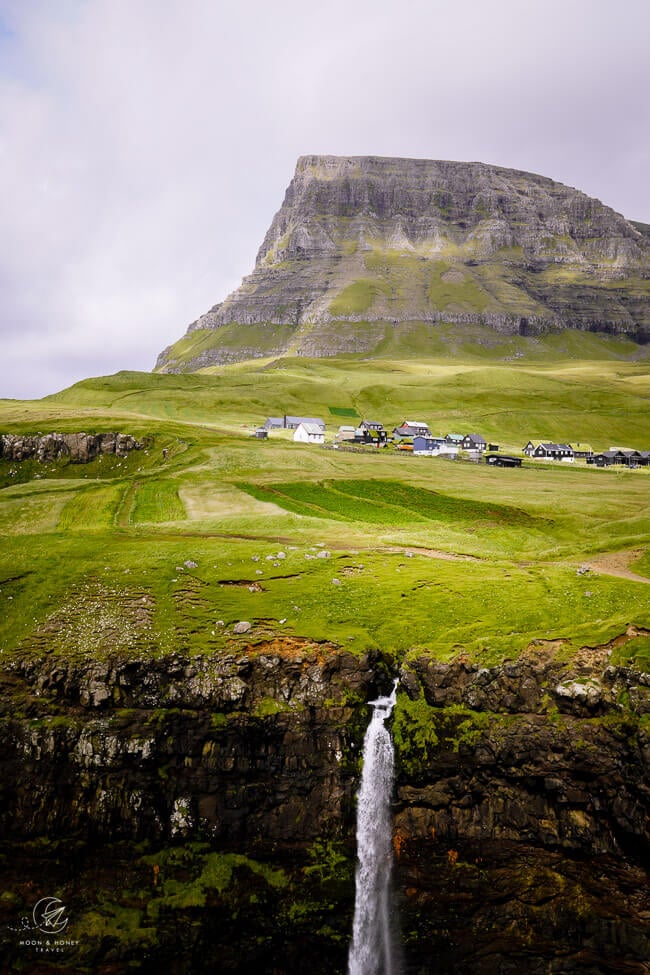
One of the most captivating attractions in the Faroe Islands is Múlafossur Waterfall (aka Gásadalur Waterfall), located in the remote village of Gásadalur on Vágar Island.
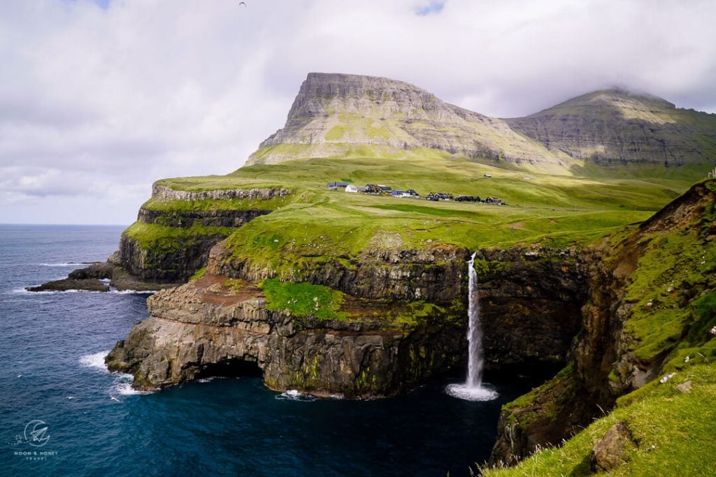
The Múlafossur Waterfall spills over the edge of a grass-carpeted sea cliff into the swelling North Atlantic Ocean below. This dreamlike scene is enhanced by the magical backdrop of Gásadalur village, dwarfed by Heinanøva (612 meters) and Árnafjall (722 meters), the highest mountain on Vágar Island.
In windy conditions, Múlafossur Waterfall sprays wildly, bending to and fro. In fair-weather, the waterfall flows in a steady stream into the cerulean waters like an offering to the ocean.
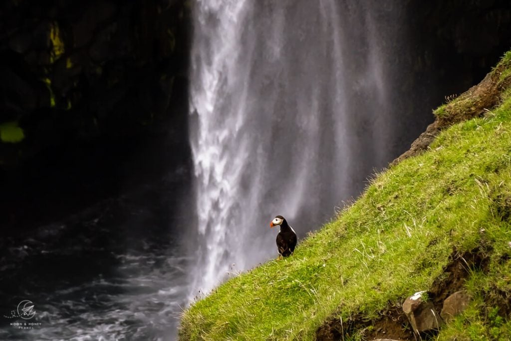
Visit between May and August, and you’ll likely see Puffins nesting in the cliffs, floating in the water, and flying around the waterfall. What could be more perfect?
Múlafossur Waterfall is often the first place people visit during their trip to the Faroe Islands, because it’s only a 17-minute drive away from the Vágar Airport.
While it’s possible to drive to Gásadalur, there’s a more interesting alternative. You can hike the old village path from Bøur to Gásadalur, known as the Postman’s Trail, or Old Mail Route.
The Postman’s Trail is a must-do hike in the Faroe Islands. It offers fantastic views of Drangarnir sea stack, Tindhólmur Island, Gáshólmur Island, and Mykines Island. And, it’s by far the most rewarding approach to Múlafossur Waterfall, the most famous waterfall in the Faroe Islands.
You can hike this Gásadalur trail out-and-back, or hitchhike back through the tunnel (what we did). Don’t walk through the tunnel: it’s too dangerous.
- Where: Vágar Island
- Starting Point: Bøur-Gásadalur Trailhead Car Park | Google Maps
- Ending Point: Gásadalur Village
- Distance: 5.3 km point-to-point
- Time Needed: 2 – 2:30 hours
- Elevation Gain: 401 meters
- Elevation Loss: 521 meters
- Difficulty: Moderate – Moderately Difficult
- Minimum Elevation: 1 meter
- Maximum Elevation: 393 meters
- Hiking Fee: None
- Where to Stay in Gásadalur: Gásadalur Apartments (midrange), or Múlafossur Cottages (midrange-luxury)
- Where to Stay in Bøur: The View (luxury)
- Where to Stay in Sørvágur (close to the Vágar Airport): Pouls Airport Guesthouse (midrange), Cosy old house Vágar (midrange ), and Cottages by the Sea (luxury)
Gásadalur Hiking Map
About the Postman’s Trail: Bøur to Gásadalur Village Path

Beyond its scenic appeal, this hiking route is significant, because, up until 2004, it was the only overland connection between Gásadalur and the rest of Vágar Island.
Gásadalur residents regularly hiked over the mountains to Bøur in order to run errands, see doctors, bury corpses, and even fish, since the Gásadalur boat landing site was very poor.
In 2004, the 1.4 km single-lane Gásadalstunnilin tunnel was built, connecting the isolated village of Gásadalur with the rest of the island for the very first time. The tunnel was completed in 2006.
The old village route to Gásadalur is now a popular hiking trail.
Where to Start the Gásadalur Hike

The Gásadalur and Múlafossur Waterfall hike starts along the west coast of Vágar Island, just off of Route 45.
From Vágar Airport, head west on Route 22 in the direction of Sørvágur and then continue along Route 45 in the direction of Bøur and Gásadalur.
Drive past Bøur.
The trailhead car park is 2.8 km northwest of Bøur village, shortly before the Gásadalstunnilin tunnel.
About 350 meters before the Gásadalstunnilin tunnel entrance, there’s a gravel road which branches off on the left side. Follow this gravel road to the small car park, marked with a Bøur-Gásadalur trailhead info board.
Gravel Road Turn-Off: Google Maps
Postman’s Path Trailhead Car Park: Google Maps
While this trail follows the old village path from Bøur to Gásadalur, we don’t recommend starting the hike in Bøur village. If you start in Bøur, you would have to follow the main road until reaching the above-mentioned trailhead car park.
Gásadalur Hike Difficulty

This hike to Múlafossur Waterfall is moderate, or moderately difficult depending on your hiking experience.
The most challenging section of the hike is the descent from Skarði pass to Múlafossur Waterfall, because of the rugged, uneven terrain. This switchback descent requires surefootedness and comfort hiking over loose rocks.
It’s essential to wear sturdy hiking boots with excellent grip to avoid slipping.
Múlafossur Waterfall and Gásadalur Hiking Trail Description
Postman’s Trailhead Car Park to Liksteinur (30 minutes)

The trailhead is marked with a hiking info board detailing the Bøur to Gásadalur Hiking Route.
Steeply ascend the grassy slopes of Gásadalsbrekkuna (Goosevalley Hill), waymarked with short white poles.
The Postman’s Trail runs along the cliffs with a gratifying outlook towards Sørvágsfjørður fjord punctuated by the Drangarnir sea stack and the Tindhólmur and Gáshólmur Islands.

After about 20 minutes, the path leads towards the cliff edge, where there’s a dramatic view of a sheer sea cliff and Mykines Island. Maintain a safe distance from the cliff edge.
The way rises in zigzags up the cliff to Líksteinurin (“Corpse Stone”), marked with a plaque. The cemetery in Gásadalur dates back to 1873. Before then, Gásadalur residents were buried in Bøur. That means that coffins had to be carried over the mountains along this very route from Gásadalur to Bøur. The coffin bearers placed the coffins on the Líksteinurin stone in order to rest.
Líksteinurin – Vívdá Spring – Á Skarði (20 minutes)

The Bøur-Gásadalur trail continues to be marked, now with more cairns and orange pole markers.
Though the ascent continues, the gradient is far gentler. Sheep gather and graze here, creating the quintessential Faroese landscape.
After about 10 minutes, you’ll arrive at the Vígdá Spring, marked with a plaque. Locals chronicle a story of a sick baby from Gásadalur who needed medical attention in Bøur. Fearing for the baby’s eternal soul, the priest blessed the Vígdá Spring and baptized the baby right there.
The trail, now level, continues onwards through Lírabergi valley with Rógvukollur mountain (464 meters) and Knaven mountain (485 meters) off to the right. The path then angles up to Á Skarði pass.

From here, views open up to the rugged coastline and Gásadalur Valley (aka Goose Valley), flanked by Heinanøva (612 meters), Árnafjall (722 meters), and a procession of mountains.
The tiny cluster of houses at the end of the paved road is Gásadalur village.
Á Skarði to Múlafossur Waterfall Viewpoint (45 minutes)

The path twists down the rocky mountainside in steep switchbacks. It’s significantly rougher than the beginning of the hike, with very uneven terrain.
As you lose elevation, the trail gets easier and softer.
Eventually, the Bøur-Gásadalur village trail intersects with the road (Route 45), not too far from the tunnel entrance.
Follow the road into Gásadalur.
Do not take the footpath, which bypasses the road, unless you want to experience a scene from Alfred Hitchcock’s Birds. The footpath crosses near an arctic tern breeding site in summer. We had no idea until these birds started raising the alarm and swooping at our heads with a vengeance.
Luckily unharmed, though startled, we rejoined the road as fast as possible.

Before reaching the village, turn left onto the gravel farm road to the coast, following the “Múlafossur 300 m” sign. This path crosses in front of a farmstead and leads to the Múlafossur Waterfall viewpoint.
Walk through the gate, making sure to close it behind you.

The first Múlafossur Waterfall viewpoint is conspicuous, as it’s rimmed with a fence for safety reasons.
For the more “iconic photo spot,” keep following the path. There are splendid views along the guardrail, just before the stairs.
When we visited, the stairs to the beach were officially blocked.
Múlafossur Waterfall Viewpoint to Gásadalur Village (15 minutes)
Retrace your steps and then turn left, following the cliffside trail to the village. The trail soon crosses the Dalsá river over a small footbridge.
From this pathway, we were able to see many puffins flying to and from the sea cliffs.

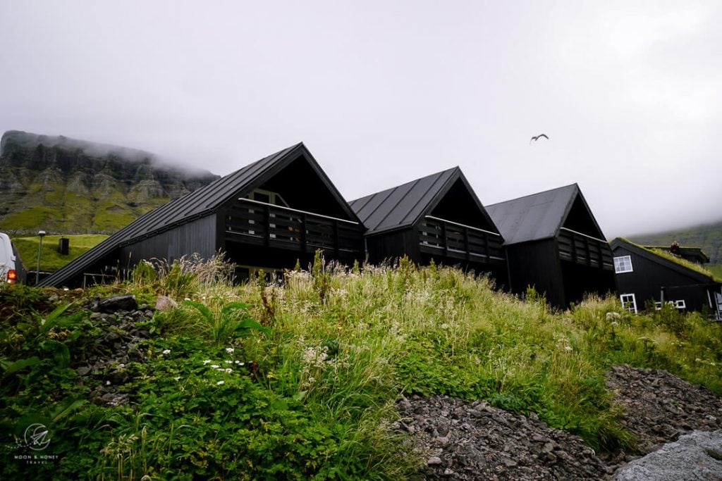
The grassy trail wraps around a large fenced-off field and leads into Gásadalur village, mostly made up of black timber houses, some with turf roofs. There’s a single café in town, called Gasadalsgardur Cafe. In high season, the café is open daily from 11 am until 4 pm.
Public toilets are located next to the car park in front of Gásadalur Apartments.
Return to Postman’s Path Trailhead Car Park

Terrified of a repeat Arctic Tern experience, we hitchhiked through the tunnel. Thank you ever so much kind Midwesterners.
If you can’t catch a ride (unlikely), return to the trailhead along the same route.
Where to Stay near Múlafossur Waterfall
Gásadalur, Vágar Island
Midrange-Luxury | Gásadalur Apartments is blissfully situated in the heart of the village. Each spacious apartment features a modern, fully-equipped kitchen, two bedrooms, a living room with a sofa bed, and private bathroom.
Luxury | Múlafossur Cottages is a lovely cottage with two bedrooms, a kitchen, and bathroom. The cottage is a short walk away from the village center and Múlafossur Waterfall.
Bøur, Vágar Island

Bøur is a tiny coastal village with turf roofed houses, narrow streets, and a church, which was built in 1865. Bøur is a quick drive to Gásadalur, the Sørvágur port (Mykines Ferry), and the Vágar Airport. From Bøur, you can kayak to the Drangarnir sea stack.
Luxury | The View (3 nights minimum) is a much sought after accommodation in the Faroe Island, because of its dreamy coastal setting facing Drangarnir and Tindhólmur and its modern comforts (floor heating, washing machine, etc…). Each turf roofed cottage offers a fully equipped kitchen,living room, 2 bedrooms, and a bathroom.
Sørvágur, Vágar Island
Sørvágur is a coastal village between Bøur and the Vágar Airport. The ferry to Mykines Island departs from the Sørvágur port. Sørvágur is a great base for exploring Vágar Island. Several exciting boat tours start in Sørvágur: Mykines Island (7 hours), Tindhólmur tour (3 hours), Drangarnir sea arch boat tour and hike (2 hours), and the Drangarnir boat tour (1 hour).
Budget | Set along a tumbling stream, Gróthusið offers private and simple facilities. This tiny stone cottage has a kitchen, bedroom (below the roof), and bathroom. Everything is quite small.
Budget | Pouls Airport Guesthouse offers basic, but nonetheless comfortable rooms. Guests have access to a shared kitchen. Bathroom facilities are shared. The breakfast is self-service.
Midrange | Cosy old house Vágar is a charming holiday home with a well-equipped kitchen, two bedrooms, a washing machine, a seating room, and a garden. There’s a grocery store next door.
Midrange-Luxury | Cottages by the Sea are 5 coastal cottages along Sørvágsfjørður fjord. Each cottage has two-bedrooms, a kitchenette, dining table, and sofa.
Look for accommodation in Sørvágur.
Tórshavn, Streymoy Island
Tórshavn, the capital of the Faroe Islands, is located on Streymoy Island. Not surprisingly, it’s also the largest and liveliest city in the Faroes, with the highest concentration of accommodations, restaurants, and bars.
Many travelers decide to base themselves in Tórshavn for the full duration of their trip and take day trips to Saksun and Tjørnuvík, Vágar Island (Múlafossur Waterfall and Trælanípa Cliff Trail), Eysturoy Island (Gjogv Village and Hvíthamar Viewpoint), Borðoy Island (Klaksvík and Klakkur Viewpoint), Kalsoy Island (Kallur Lighthouse), and even Viðoy Island (Villingardalsfjall Hike).
From Tórshavn, you can also take ferries to Nólsoy Island, Sandoy Island, and Suðuroy Island.
TOP CHOICE – Midrange-Luxury | Hilton Garden Inn Faroe Islands is a fresh-faced hotel set in a quiet location, 1.6 km from the city center (20 minute walk, or 4 minutes drive). Stay here for the impeccably-designed rooms with comfortable beds, the on-site restaurant and bar, great breakfast buffet, and fitness center. Free on-site parking.
Luxury | Hotel Brandan is a 4-star hotel with quiet rooms, an on-site restaurant, a fitness center, a sauna, and on-site parking. Guests love the breakfast and the hotel bar, which serves local craft beers. The hotel is located 1.4 km from the city center (15 minute walk, or 3 minute drive).
Luxury | Havgrím Seaside Hotel 1948 is a boutique hotel set on the seashore, walking distance to the city center (10 minutes). A fantastic breakfast is included. Free parking is available on-site. Guests can also enjoy the garden hot tub facing the sea.
Luxury | Traditional Faroese house in Tórshavns city center is a 4-bedroom turf-roofed house with stylish, renovated interiors, two bathrooms, and a well-equipped kitchen. Free on-site parking. 3 nights minimum stay.
More Charming Holiday Homes: Cosy house in the heart of Tórshavn (Á Reyni) and Luxurious House in Downtown Tórshavn
City Center Apartments: City center, Tórshavn (2-bedroom apartment), Central apartment in Tórshavn (1-bedroom apartment), Penthouse Apartment in Downtown Tórshavn (3-bedroom/5 people apartment)
Look for accommodation in Tórshavn.

Faroe Islands Travel Essentials
Faroe Islands Rental Car
The most practical way to travel between destinations in the Faroe Islands is with your own car. Plan your trip with our Faroe Islands road trip itinerary.
We recommend using the Discovercars.com car rental reservation platform to search for and book car rentals in the Faroe Islands. This easy-to-use booking platform compares car rental deals from 500+ trusted providers, so that you can choose the best option for your trip.
You can also book a complete self drive vacation package, which includes accommodation, car rental, and various guided day tours:
- Epic 8 Day Summer Self Drive Tour of Faroe Islands
- Unforgettable 10 Day Self Drive Tour of Faroe Islands with Top Attractions
Adventurous Faroe Islands Tours
- Panoramic 6 Hour Tour to Mount Slættaratindur: hike to the summit of Mount Slættaratindur, the highest mountain in the Faroes. This guided tour starts in Tórshavn.
- Wild 8 hour Hike to Cape Enniberg: hike to Mount Villingardalsfjall and onwards to Cape Enniberg (only possible with a guide), one of the highest promontories in the world, on Viðoy Island. This guided excursion starts in Tórshavn.
- Kayaking to Drangarnir: 2:30 hour kayak tour of the Drangarnir sea arch starting in the village of Bøur on Vágar Island.
- Exciting 2 Hour Combined Boat Tour and Hike to Drangarnir Sea Arch: 2 hour tour starting in Sørvágur harbor on Vágar Island.
- Hike from Mikladalur to Trøllanes: 8 hour guided hike on Kalsoy Island starting in Klaksvík, Borðoy Island.
Faroe Islands Guided Day Trips
Here are some popular guided day trips starting and ending in Tórshavn.
- The Northern Islands and Tjørnuvík: 9 hour guided tour of the Northern Isles.
- The Classic Mykines Tour: 6 hour guided tour of Mykines Island.
- Popular 7.5 Hour Vestmanna Bird Cliffs & Múlafossur Waterfall Tour: 7:30 hour guided tour including a boat tour of Vestmanna cliffs.
- Incredible 8 hour Guided Tour to Kalsoy & Kallur Lighthouse: 8 hour guided tour of Kallur Island.
Outdoor Photographer Gear
- Camera Body: Sony Alpha a6400
- Mid-range Zoom Lens: Tamron 17-70mm 2.8 Di III-A VC RXD
- Wide angle Zoom Lens: Sony – E 10-18mm F4 OSS Wide-angle Zoom Lens
- Backpack Camera Clip: Peak Design Camera Clip
More Faroe Islands Travel Guides
Hiking Trails
Read Best Hikes in the Faroe Islands for a summary of the top hiking trails across the archipelago. Faroe Islands hiking trails (north to south):
- Villingardalsfjall Hike, Viðoy Island
- Árnafjørður – Toftaskarð – Katlarnir Circuit Trail, Borðoy Island
- Klakkur Hike, Borðoy Island
- Kallur Lighthouse Hike, Kalsoy Island
- Hvíthamar Viewpoint Hike, Eysturoy Island
- Saksun to Tjørnuvík Hike, Streymoy Island
- Múlafossur Waterfall and Gásadalur Hike, Vágar Island
- Lake Sørvágsvatn and Trælanípa Cliff Hike (Floating Lake Viewpoint), Vágar Island
- Ásmundarstakkur Hike, Suðuroy Island
- Hvannhagi and Lake Hvannavatn, Suðuroy Island
Trip Planning Guides

Pin this Image for Future Trip Planning!
Stay Connected:
Connect with us on Pinterest.
Follow us on Instagram.
Like us on Facebook.
Support Us:
If you love reading our content, you can buy us a coffee via Ko-Fi.
