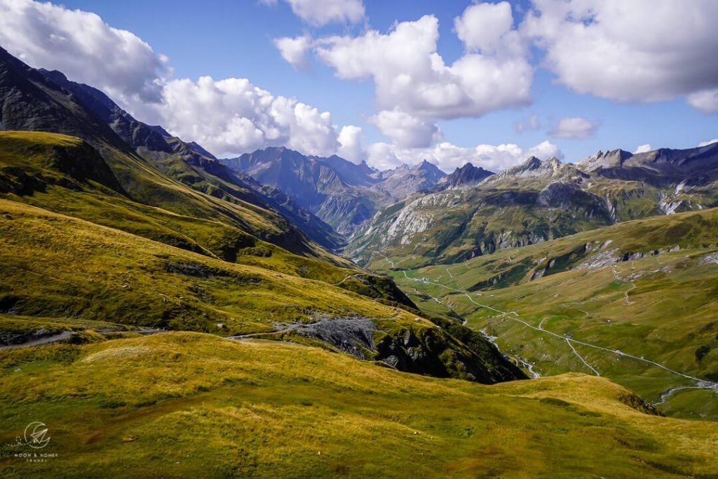
Stage 4 of the Tour du Mont Blanc crosses from France into Italy via the Col de Seigne saddle.
From Refuge de la Croix du Bonhomme, the main Tour du Mont Blanc route drops down to Chapieux. However, there’s a wonderful variant that bypasses Chapieux and effectively trims off 3.7 km.
The official Col des Fours variant is a gorgeous, lonesome route, though perhaps a bit more demanding than previous stages. It’s only recommended to hike this variant when the weather is stable and the trail is clear of snow.
The Col des Fours variant descends to La Ville des Glaciers in Vallée des Glaciers, where it rejoins the main TMB trail. After passing the idyllic Refuge des Mottets, the path steadily ascends to Col de Seigne (2516 m), the gateway to Italy.
From the saddle, the TMB descends to Val Veny in Aosta Valley, Italy’s smallest region.
Rifugio Elisabetta is a great spot for lunch. You can stay overnight here, or continue down the valley to the lovely Cabane du Combal.

- Starting Point: Refuge de la Croix du Bonhomme, France
- Ending Point: Cabane du Combal, Italy
- Distance: 18.2 km point-to-point
- Time Needed: 6:45 hours
- Elevation Gain: 988 meters
- Elevation Loss: 1458 meters
- Difficulty: Moderate
- Minimum Elevation: 1768 meters
- Maximum Elevation: 2665 meters
- Where to Stay: Cabane du Combal (Rifugio Combal), or Rifugio Elisabetta
- Self-Guided Hiking Tour: 10 Day Standard Tour du Mont Blanc (what we booked) / 10 Day Comfort Tour du Mont Blanc (private rooms only)
Refuge de la Croix du Bonhomme – Cabane du Combal Trail Map
Refuge de la Croix du Bonhomme – Col des Fours – Col de Seigne – Cabane du Combal Trail Description
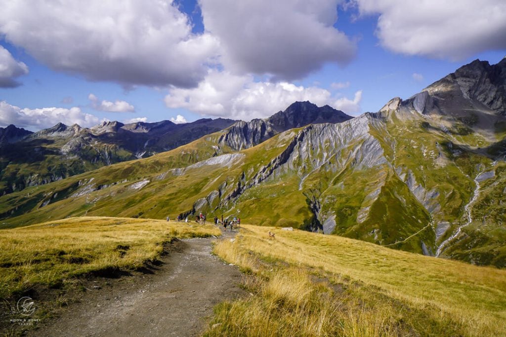
Refuge de la Croix du Bonhomme to Col des Fours (30 minutes)
Retrace your steps back to Col de la Croix (5 minutes) and turn right, following signs to Col des Fours.
After a few minutes, the trail divides. You can take either trail, though the right trail might be a bit easier.
The divergent paths link up and ascend to the Col des Fours saddle (2665 m).
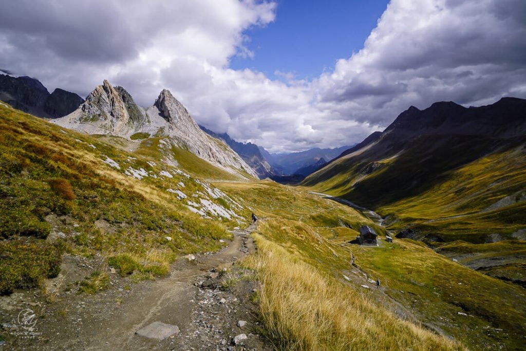
Col des Fours to La Ville des Glaciers (2 hours)

From the saddle, a narrow path slithers southeast down a steep shale slope. To the northeast, the snow and ice-capped Aiguille des Glaciers looms above a layered landscape of falling ridgelines.
After 30 minutes, the trail reaches the basin area of Plan des Fours.
Following the sign to La Ville des Glaciers (1:30 hours), cross the basin, furrowed with rivulets.
The narrow path descends alongside the Tufs stream. Some passages are washed out and slippery. Take extra care.

After crossing the Tufs stream, the undulating path meanders across a pasture area with grazing cattle.
Soon, the path makes a sharp right (marked with a wooden pole and a yellow arrow) and descends across meadows, parallel to the stream.
Keep your eyes out for thread-like pasture fences, which are difficult to see in the morning light.
The TMB joins a farm road and passes the vacant alp buildings of Les Tufs (1993 m).
The final leg to Ville des Glaciers is marked with short timber poles with yellow blazes. Descend this waymarked trail and then rejoin the farm road to La Ville des Glaciers (1789 m), a cluster of farm buildings.
La Ville des Glaciers to Les Mottets (30 minutes)

Here, the Col des Fours Variant joins the main TMB route.
Follow signs to Refuge des Mottets (30 minutes), Col de la Seigne (2:30 hours), and Refuge Elisabetta (3:10 hours).
Cross the road and follow the gravel track down to the Torrent des Glaciers river. The track crosses the river and then gently ascends Vallée des Glaciers with wonderful views of Aiguille des Glaciers (3815 m).

The trail leads to Refuge des Mottets (1870 m), a former dairy farm which is now a bustling refuge. It’s one of the most heavenly-positioned huts along the Tour du Mont Blanc.
Les Mottets to Col de Seigne (1:45 hours)
At the Les Mottets (1870) signed junction, continue to Col de la Seigne (1:55 hours), bypassing Refuge des Mottets.
The wide trail rises steadily above Vallée des Glaciers.
With the elevation gain, the valley views crescendo in beauty.
The way to Col de Seigne isn’t difficult, but it drags on.
Col de Seigne to Rifugio Elisabetta (50 minutes)
The wide Col de Seigne (2516 m) saddle marks the border between France and Italy.
The Tour du Mont Blanc continues easily into Italy’s Vallon de la Lex Blanche, the upper reaches of Val Veny. The landscape is compelling, though harsh and desolate.
Pass the stone building of Casermetta de la Seigne, a former customs house, and continue descending the valley.
The trail leads alongside the wide pasture area of Lée Blanche, where cattle graze in summer, to a cluster of Alp buildings.
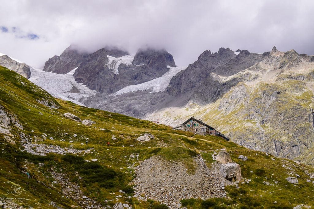
From here, turn left and hike up to Rifugio Elisabetta (2194 m) for lunch, toilets, espresso, etc… coupled with impressive glacier views.
There’s table service. Only order espresso drinks at the counter. Payment is cash only.
Note: many people choose to stay overnight in Rifugio Elisabetta. However, we’d caution you against it, because the dormitories looked terribly cramped.
Rifugio Elisabetta to Cabane du Combal (1 hour)

Return to the main trail and continue hiking down the valley on the wide gravel road.
A long flat stretch brings you to a wetland area and ultimately Lago Combal/Lac du Combal lake.
Cross the bridge over the Dora di Veny river and turn left to the A-frame Cabane du Combal (Rifugio Combal).
Before settling in, you can detour to the tiny Lago del Miage/Lac du Miage glacial lake, just 10-15 minutes away from the hut.
Stay in Cabane du Combal

Cabane du Combal (also called Rifugio Combal) is a darling, intimate accommodation along the TMB. It has an almost boutique quality. The rooms are spacious and comfortable. We relished the en suite bathroom. Though the food wasn’t outstanding, we’d stay here again and again, because everything else was perfect.
Check-in | 4 pm. The staff is really kind, but the check-in process was very slow. Guests must present their passport during check-in.
Rooms | Private and 4-person rooms with en suite bathrooms (toilet, sink, and shower). Sheets are changed daily, so you don’t need to use a sleeping bag liner.
Payment | Cash or credit card
Dinner | Dinner is served at a designated time. The food was ok.
Breakfast | An “Italian-style” breakfast is laid out in the morning.
Lunch Packet | None
Drinking Water | The water in the rooms is potable.
Electronic Charging Stations | You can charge your devices in your bedroom, or downstairs (bar area) until 9:30 pm.
Toilets | Private, en suite
Showers | Private, en suite. No extra charge. Towels provided.
Hut Rules | No shoes are allowed in the hut. Remove and store your shoes near the door.

Tour du Mont Blanc Essential Info
Read our Tour du Mont Blanc Hiking Guide to start planning your trek.
Quick Facts
- Official TMB Length: 170 km (105 miles)
- Days Needed: 10-11 days
- Which Direction to Hike: Counterclockwise
- Where to Start the TMB: Chamonix, Vallée de l’Arve, France
- Closest Airport to Chamonix: Geneva Airport, Switzerland
- When to Hike the TMB: July – early September
- When to Book the TMB: January – February
- TMB Difficulty: Moderate
- Recommended Self-Guided Tours: 10 Day Standard Tour du Mont Blanc (private and shared rooms), 10 Day Comfort Tour du Mont Blanc (private rooms only), 7 Day Tour du Mont Blanc (shortened route with transit shortcuts), 15 Day Tour du Mont Blanc (leisurely-paced route).
TMB Planning Resources
- TMB Hiking Guidebook: Cicerone: Trekking the Tour of Mont Blanc guidebook
- TMB Trail Maps: L’Escursionista Tour du Mont Blanc TMB or IGN Tour du Mont Blanc Map
Tour du Mont Blanc Route Itinerary
The Tour du Mont Blanc (TMB) is a captivating multi-day hike that circuits the Mont Blanc massif in usually 10-11 days, passing through France, Italy and Switzerland. Here’s our personal TMB itinerary.
- Stage 1: Chamonix – Le Brévent – Les Houches
- Stage 2: Les Houches – Les Contamines-Montjoie (Col de Tricot Variant)
- Stage 3: Les Contamines – Refuge de la Croix du Bonhomme
- Stage 4: Refuge de la Croix du Bonhomme – Cabane du Combal (Col Des Fours Variant)
- Stage 5: Cabane du Combal – Courmayeur – Rifugio Bertone
- Stage 6: Rifugio Bertone – Grand Col Ferret – Alpage de La Peule
- Stage 7: Alpage de La Peule – Ferret – La Fouly – Champex-Lac
- Stage 8: Champex-Lac – Trient (Fenêtre d’Arpette Variant)
- Stage 9: Trient – Col de Balme – Aiguillette des Posettes – Tré le Champ
- Stage 10: Tré le Champ – Lac Blanc – La Flégère – Chamonix
More Guides about Hiking in Europe
European Alps:
- The Alps in Summer: 10 Things You Need to Know Before Visiting
- Hiking in the European Alps
- Italian Alps Hiking Destinations
- Austrian Alps Hiking Destinations
- Slovenia Alps Hiking Guide
Multi-Day Hikes in Europe:
Hut to Hut Hiking:

Hi Sabrina & Kati,
Thank you so much for sharing all this information. It’s a godsend as we try to put together our own itinerary for the TMB.
If you don’t mind, could I ask for some further suggestions? We are in the awkward situation of having booked everything aside from the accommodation for this stage because everything got booked out. It now seems that we have to hike from Croix de la Bonhomme all the way to Visaille (about 1 hr more, I believe). This will be our first multiday hut-to-hut hiking experience, so we are a bit daunted by the prospect of a near 8-hour hike for this day. Would you happen to know of further possible shortcuts for this stage?
Any advice would be much appreciated!
Hi Sharon,
You’re very welcome!! Did you try securing accommodation at Rifugio Elisabetta? Otherwise, it might be possible to take a taxi/shuttle from the road near Cabane du Combal to Courmayeur. You could stay in a comfortable hotel in Courmayeur and then take a taxi/shuttle back to Cabane du Combal the next morning to pick up where you left off. Please confirm taxi/shuttle options with the Courmayeur tourist office.
Have an amazing hike around Mont Blanc!!
Sabrina