The Cassis – Devenson Cliffs – Luminy University Campus hike in Marseille largely follows the GR 98-51 across Calanques National Park in Southern France.
This point-to-point hike can easily be done as a day trip from Marseille, or Cassis.
It’s possible to tackle this Calanques National Park route in either direction, but we recommend starting in Cassis and hiking west, in order to ascend scrambling sections and to hike with the sun at your back. By starting in Cassis, you’ll also enjoy a quiet morning in the darling seaside town.
Though the Devenson Cliffs hike begins and ends in popular areas, the vast majority of the trail passes through quiet, untouched landscapes with mesmerizing views of sheer sea cliffs plunging into the shimmering Mediterranean. This is the “wild heart” of the Calanques.
Hiking across the high sea cliffs between Cassis and Marseille is a tremendous experience and a thrilling adventure, which affirmed that Calanques National Park is a Mediterranean destination like no other.
- Starting Point: Gendarmerie Bus Stop in Cassis (Bus line 78)
- Ending Point: Luminy PN des Calanques Bus Stop, Marseille (Bus line B1)
- Distance: 15.6 km point-to-point
- Time Needed: 6:30 hours
- Elevation Gain: 1056 meters
- Elevation Loss: 938 meters
- Difficulty: Difficult
- Minimum Elevation: 0 meters
- Maximum Elevation: 432 meters
- Trail Map: IGN Les Calanques
- Where to Stay in Cassis: Chambre d’hôtes Clos du Petit Jésus (midrange), HPC Suites (luxury), Hotel De La Plage (luxury), or Hôtel Les Roches Blanches (luxury)
- Where to Stay in Marseille: Hôtel Le M (midrange), Les Appartements du Vieux Port (midrange), Boutique Hôtel Provencia (midrange), Hôtel C2 (luxury), or Maisons du Monde Hôtel & Suites (luxury)
Cassis – Devenson Cliffs – Luminy Hiking Map
How to read this map | The Cassis-Luminy trail is highlighted in yellow. The Cassis-Calanque de’En-Vau hike, which follows the panoramic trail (optional detour), is highlighted in teal. For reference, we’ve also included the GR-98 route in gray. And finally, the green line indicates the Calanques National Park boundary.
Hiking the GR 98-51

The GR 98 is a 61 km long-distance trail from Pilon Pass to La Madrague in Marseille.
The GR 51 is a 436 km long-distance trail Menton to La Madrague in Marseille.
The GR 98 and the GR 51 overlap in Calanques National Park, which is why we and others refer to the trail as the GR 98-51.
For this specific day hike, hikers can choose between following the GR 98-51 entirely, or deviating off the white-red trail at Col de l’Oule, in order to hike the green-waymarked trail across the Devenson Cliffs.
This spectacular cliffside trail, known as Sentier des Falaises du Devenson, runs between Col de l’Eissadon (100 m) and Col des Charbonniers (284 m).
There are some other optional detours, explained below, which are worth the time and effort.
Devenson Cliffs Hike Difficulty

This is a difficult hike, due to the steep, rugged, and uneven limestone terrain. Some scrambling is needed to scale the Devenson Cliffs path, but there’s no exposure.
The ascent is accomplished in stages, so it’s never continuous. Nonetheless, the cumulative ascent is 1056 meters and the cumulative descent is 938 meters.
The Cassis to Luminy trail (green route) is not suitable for children, because the path follows a clifftop, where there are no barriers, or fencing.
We don’t recommend hiking this route across the Devenson Cliffs on windy days.
Cassis – Luminy Hike Transit Logistics

We tackled this Cassis-Luminy hiking trail as a day trip from Marseille.
In the morning, we took Bus 78 from Castellane to Cassis (45 minutes). This Marseille-Cassis bus is included in the 7-Day RTM Pass. You can also purchase the bus ticket on the bus upon entering.
During our visit, Castellane was under construction. Bus 78 departed from Avenue de Toulon (Google Maps), near the roundabout. Check lecaraixmarseille.com for updates.
The hike ends at Luminy University Campus. We took Bus B1 from Luminy PN des Calanques (Google Maps) to Castellane (35 minutes). This bus ride is included in the 7-Day RTM Pass. There is a ticket machine at the bus stop where you can purchase a bus ticket, before entering the bus.
Waymarking and Signage

Trail junctions are signed with directions, mostly painted on rocks.
Waymarks are painted in different colors, which indicate different routes. These can be confusing, because they often overlap.
The vast majority of the route follows the green trail. You only depart the green trail on the last stretch to Luminy, when you exit the GR 98-51.
The route also follows the red-white GR 98-51, but as stated before, we recommend detouring on the green route in order to follow the cliffside coastal path.
Optional Detours along the GR 98-51

The Cassis – Luminy hiking route is 15.6 km point-to-point.
If temperatures are mild and you have the stamina for a longer hike, you can also follow the panoramic trail from Plage de Port Pin to Le Portalet d’en Vau, rather than staying on the direct GR 98-51.
Furthermore, you can detour to Calanque d’en Vau Beach, before continuing the hike to Col de l’Oule (231 m).
From Col de l’Oule, there’s an optional detour to Belvédère d’En-Vau.
And from Col de Sugiton, near the end of the hike, there’s an optional detour to Belvédère de Sugiton, an epic viewpoint with sweeping views of the cliffed coast.
Cassis to Luminy Trail Description
Gendarmerie Bus Stop – Port of Cassis – Calanque de Port-Miou (45 minutes)

From the Gendarmerie Bus Stop in Cassis, walk to the roundabout and turn right on Rue de la Ciotat and later left on Avenue Victor Hugo to reach the harbor.
When you reach the attractive port of Cassis, turn right and follow the pedestrian promenade along the water.
Turn right on Avenue de l’Amiral Ganteaume and follow this street in a westerly direction to Plage du Bestouan.
Soon after passing the Bestouan Beach, turn right on Trav. du Soleil, following the red and white sticker trail markers.
Turn right again on the residential Avenue Révérend Père Jayne, which later turns into Avenue des Calanques as you progress.

Avenue des Calanques slopes down, steering you to the Port-Miou Calanques National Park trailhead, marked by signs and info boards. Turn left at the gate, following signs to Calanque de Port-Pin and Calanque d’en Vau.
The way is marked with green and red-white waymarks
Calanque de Port-Miou – Calanque de Port-Pin – Plage de Port Pin (25 minutes)

The GR 98-51 follows a wide gravel path, beneath vertical cliffs and above Calanque de Port-Miou, a narrow strip of water, home to the local yacht club.
With peekaboo views of Calanque de Port-Miou, the flat trail progresses towards the mouth of Calanque de Port-Miou and splits.
The scenic left path hugs the coast, following the contours of the Port-Miou Calanque. The right gravel trail rises steadily to the crest. Both trails converge atop the crest, before dropping down the timber-post-flanked trail to Port Pin beach.
Plage de Port Pin to Le Portalet d’en Vau (25 minutes)

From the pebbly Plage de Port Pin, the trail divides. You can either follow the left panoramic trail (longer, scenic, marked in blue), or stay on the direct GR 98-51 (shorter, direct, marked in red/white) to reach Le Portalet d’en Vau.
Note: the panoramic trail will add ~1 km and ~40 minutes to the hike. You can see photos of the trail in our Calanque d’En-vau hiking guide.
We hiked the direct GR 98-51 to Le Portalet d’en Vau, which ascends continuously through bush and forest.
Le Portalet d’en Vau to Col de l’Oule (40 minutes)

The panoramic blue-marked trail and the red-white GR 98-51 merge atop Le Portalet d’en Vau.
The path drops down steeply in the direction of Calanque d’En-vau (signed 30 minutes). The terrain is rocky and rugged, with steep steps and loose rock. There are a few handrails for security. Eventually, the path smooths out in the valley, at the base of towering cliffs.

At the next junction, you can either detour left to Calanque d’En-vau beach (add 1.4 km / 30 min out-and-back), or continue right on the GR 98-51.
Heading right, the GR 98-51 leads inland, slowly ascending along a pleasantly smooth path through Vallon d’en Vau.

After about 10 minutes, turn left, following the painted rock sign to Belvedere and Devenson, and ascend the narrow path to Col de l’Oule (231 m), where a paved road ends. This is where the detour to Belvédère d’En-Vau starts (add 1.6 km / 30 minutes out-and-back).
Col de l’Oule to Col de l’Eissadon (35 minutes)

The way leads west to another junction. Ignore the trail to Cap Gros. At the next intersection, marked with a signed rock, turn left along the green route to L’Eissadon.
Here, we deviate from the GR 98-51.
The green-waymarked trail leads to the coast through forest, providing comforting shade on a hot day, and then abruptly ascends to reach Col de l’Eissadon.

Here, the trail returns to the sea, though a good 100 meters above sea level.
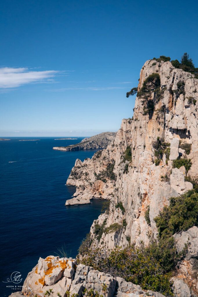
Col de l’Eissadon to Col du Devenson (1 hour)

Turn right and ascend the steep and rugged cliffside trail. There are some scrambling sections along the ascent, which are steep, but never exposed.

The trail levels across the cliffs and the views of the coast and the Riou archipelago are sensational.
The trail progresses along the cliffs to a green cross, Croix de Gasquet, and then continues to Col du Devenson (242 m)

The green route and the red-white route merge at Col du Devenson.
Col du Devenson to Col des Charbonniers (35 minutes)

The red-white / green trail, otherwise known as the Sentier des Falaises du Devenson, ascends once again and then levels across the Devenson Cliffs.
Views open up to Grande Candelle summit (454 m), Cap Morgiou, and the mouths of Calanque Sugiton and Calanque Morgiou.

After a much-needed break atop the Devenson Cliffs, we descended to Col des Charbonniers (284 m).
Col des Charbonniers to Col de la Candelle (40 minutes)

The hike from Col des Charbonniers (284 m) to Col de la Candelle (430 m), the highest point along the trail, is the final ascent along today’s hike.
The GR 98-51 takes a circuitous route to Col de la Candelle, heading inland, before returning to the coast, effectively wrapping around Val Vierge.

The path follows a crest to reach Col de la Candelle, which rewards hikers with picture-perfect views of the Calanques Massif, unfurling into the sea.
Col de la Candelle to Col de Sugiton (1 hour)

The descent to Col de Sugiton follows the red/white, green, yellow, and red waymarked routes, otherwise known as the Sentier des Treize Contours.
Expect loose rocky terrain along this stretch.
The path develops into a balcony trail, before twisting down to join a wide, well-groomed gravel track.
When the path joins a wide gravel track, turn right to Col de Sugiton.
Optional Detour: Col de Sugiton to Belvédère de Sugiton (20 minutes out-and-back)

From Col de Sugiton, we recommend detouring to Belvédère de Sugiton before completing the hike.
A flat, wide gravel track leads to the viewpoint in 10 minutes.
The Sugiton viewpoint affords panoramic views of the coastline, including the impressive Grande Candelle and Devenson Cliffs to the east and Calanque Morgiou to the west.
The lookout point is located on the site of a former military watchtower built by the Germans during the Second World War.
Col de Sugiton to Luminy PN des Calanques (30 minutes)
The way to Luminy is signed and easy to find. There are a lot of people on this stretch of trail, since it’s the most popular entry point into the Calanques National Park.
The wide track leads inland through forest to the car park at Luminy. Follow Avenue de Luminy until you see the Luminy PN des Calanques bus stop.
Hop on bus B1 to return to Marseille (35 minutes).
To get to Cassis, ride bus B1 to Le Redon (5 minutes), where you’ll change to bus 78 to Cassis (20 minutes). See more transit options in Google Maps.
Where to Stay near Calanques National Park
Cassis

Top Choice – Midrange | Managed by caring hosts, Chambre d’hôtes Clos du Petit Jésus is a quiet and comfortable B&B with an outdoor swimming pool, terrace, and generous breakfast. Parking is included. The guesthouse is a short 10-minute walk to the port of Cassis.
Luxury | HPC Suites offers well-kept, self-catering apartments in an idyllic and central location in Cassis, walking distance to the port (10 minutes). Free parking is available.
Luxury | Hotel De La Plage – Mahogany is situated along Avenue de l’Amiral Ganteaume across from Plage du Bestouan beach, a 5-minute walk from the Port of Cassis. This beachfront hotel offers 28 comfortable, air-conditioned rooms, many of which have sea views. Extra perks: sunny sea-facing terrace, bar, restaurant (summer only), spa and pool (seasonal / extra charge). Parking is available for an extra fee (reserve in advance).
Top Choice – Luxury | Hôtel Les Roches Blanches occupies a privileged cliffside position in Cassis, overlooking the sea and Cap canaille. Stay here for the dreamy setting and excellent breakfast. Restaurants and pools are open seasonally. Book a sea-view room. On-site parking is available for an extra fee.
Look for accommodation in Cassis.
Marseille

Midrange | Hôtel Le M is a comfortable 3-star hotel located on Rue Paradis, a safe commercial street, near the Estrangin metro station and walking distance to both Vieux Port and Castellane. All rooms have air-conditioning and are equipped with a coffee machine and tea kettle. Staying here is very relaxing and uncomplicated: luggage storage is provided, breakfast is available (you can decide each morning whether you’d like breakfast), check-in and check-out is efficient.
Midrange | Le Pythéas – Vue Vieux-Port avec terrasse et clim is a light-filled spacious apartment in Vieux Port. We loved the location and layout of the apartment. However, it would need a few upgrades (more towels, towel racks, more efficient self-check-in). Also check out this similar apartment: Le Pythéas Vieux Port Marseille.
Budget-Midrange | Top-rated Les Appartements du Vieux Port offers a wide array of clean, modern, air-conditioned apartments in a central location in Vieux Port.
Luxury | Maisons du Monde Hôtel & Suites – Marseille Vieux Port stands prominently across the ferry terminal of Vieux Port. This chic portside hotel offers air-conditioned rooms, lovingly furnished with Maisons du Monde decor. Book a room with a harbor view. Breakfast is available.
Top Choice – Luxury | Housed in a 19th century private mansion, the stylish boutique Hôtel C2 stands out with its bright contemporary rooms, spa, fabulous breakfast, and phenomenal service.
Look for accommodation in Marseille.
Southern France Travel Guides
Marseille:
Calanques National Park:
- How to Visit Calanques National Park
- Hiking in Calanques National Park
- Cassis – Calanque d’En Vau Hike
- Calanque de Sugiton – Calanque de Morgiou Hike
- Calanque de Sormiou – Les Goudes Hike


Pin this Image for Future Trip Planning!
Stay Connected:
Connect with us on Pinterest.
Follow us on Instagram.
Like us on Facebook.
Support Us:
If you love reading our content, you can tip us via Ko-Fi.
