Hiking in the Dolomites Mountains is an intoxicating outdoor, cultural, and culinary experience. From the tear-inducing beauty of the peaks to the charm and hospitality of the mountain huts, hiking here can easily become an addiction.
If mountain ranges were musical genres then the Italian Dolomites would be opera – like La Traviata or Eugene Onegin. You know the ones that are so achingly beautiful that crying is the only appropriate response.
This guide presents the best hikes in the Dolomites, ranging from delightfully easy walks to very demanding peak hikes. The best Dolomites day hikes are concentrated around Cortina d’Ampezzo, Alta Pusteria, Alta Badia, Val di Funes, Val Gardena, and San Martino di Castrozza.
When planning a Dolomites hiking trip, it’s important to understand the enormity of this Italian Alps mountain range. The Dolomites are composed of 26 sub-ranges and stretch across three Italian regions: Veneto, Trentino Alto-Adige (Trentino – Südtirol), and Friuli Venezia Giulia.
At the very minimum, you need five to seven days to hike in the Dolomites. The more time you have, the better. We’ve visited the Dolomites ten times and we never run out of things to do, or trails to hike.
It’s possible to plan a shorter trip if you concentrate your time in one area (e.g. Val Gardena, Alta Badia, Cortina d’Ampezzo, etc…).
Important | These Dolomites trails are ordered by difficulty. Trails 1-12 are easy, trails 13-22 are moderate, trails 23-28 are moderately difficult, and trails 29-40 are challenging.
- When to Hike: June – September (October)
- Where to Stay for Hiking in the Dolomites: Val Gardena, Alta Badia, San Martino di Castrozza, Alta Pusteria, Cortina d’Ampezzo, and/or Val di Funes
- Trail Signage: Hiking trails are very well-signed
- Languages Spoken in the Dolomites: Italian, Ladin, and German
- Hiking Difficulty: There are hikes in the Dolomites for all experience levels.
- Hiking Gear Essentials: Grade B/C High-Cut Hiking Boots, Black Diamond Trail Trekking Poles, Cat 3-4 Sunglasses like the Julbo Fury Photochromic Sunglasses, Women’s Osprey Tempest 34 Hiking Backpack or the Men’s Osprey Talon 33 Hiking Backpack.
- Dolomites Itineraries: 5 Day Dolomites Road Trip, 7 Day Dolomites Road Trip, and 10-14 Day Dolomites Road Trip
- Get the Guidebook: Cicerone Guide: Shorter Walks in the Dolomites
Dolomites Hiking Map
Each trail mentioned in this guide is displayed on the map. If you click the trail, you can directly access the respective trail guide.
Colors signify regions. For example, the Dolomites hikes starting in Val Gardena are marked in coral red. The Dolomites hikes starting in Alta Pusteria are marked in blue.
DOLOMITES HIKING REGIONS
Where to Stay
Val di Fassa
Val d’Ega
Easy Hikes in the Dolomites
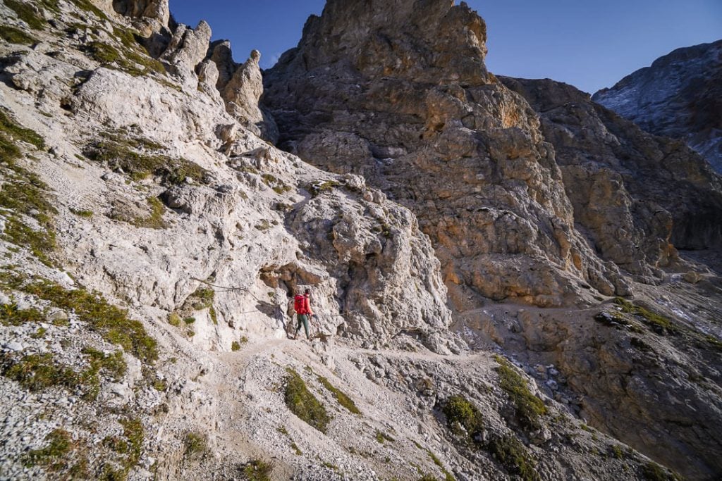
1. Seceda Ridgeline to Regensburger Hütte Circuit Hike

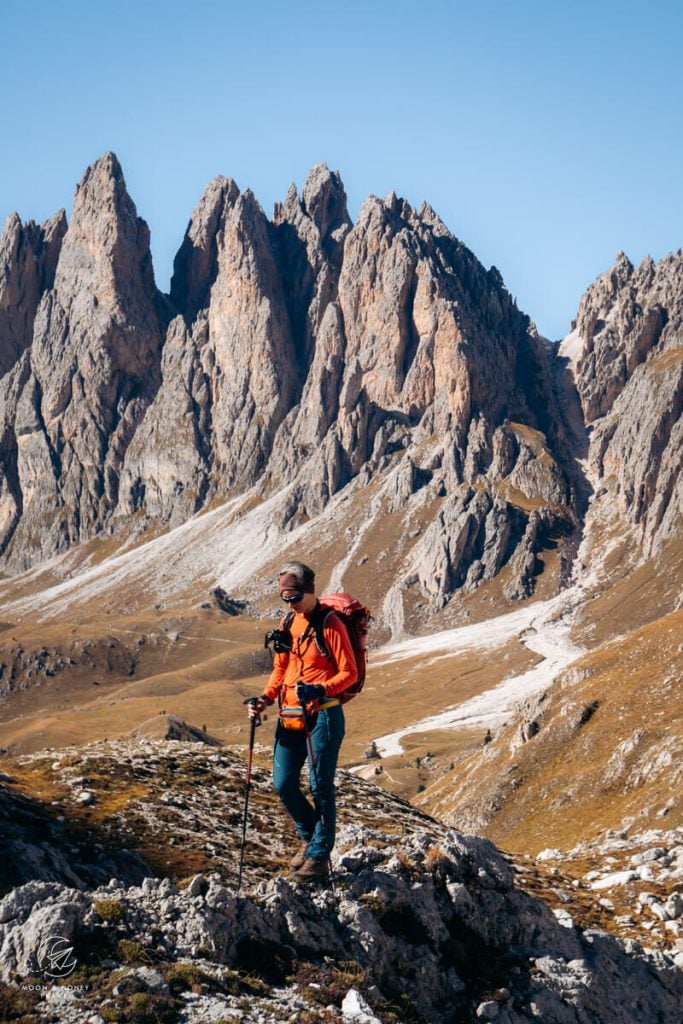
Seceda is a mountain in the Odle/Geisler Group in South Tyrol. The Seceda summit (2518 meters) is one of the most celebrated photography spots in the Dolomites, because of its striking view of the dagger-like Fermeda Peaks.
The easiest and swiftest way to reach Seceda is by cableway ascent from the village of Ortisei in Val Gardena. From the Seceda cableway mountain station, it’s a mere 10-minute walk to the Seceda summit.
This dazzling location is just the beginning of a wonderful loop trail in Puez Odle Nature Park. From the summit, follow the Seceda ridgeline in the direction of the staggering Odle/Geisler peaks.
When you reach the Furcella de Pana/Panascharte notch, continue right on trail 1 in the direction of Baita Troier. The dizzy trail that plummets to the left leads to Val di Funes and is currently closed due to a rockfall.
At the next intersection, turn left on trail 2B, and hike to the Pieralongia alpine pasture hut. The trail continues to Rifugio Firenze/Regensburger Hütte, a mountain hut at the foot of Mount Stevia, facing Sassolungo.
You can eat lunch at the hut, before completing the circuit to Seceda.
Seceda Hiking Tips
When to Hike | The Ortisei-Furnes-Seceda cableways usually operate from early June until mid-October. See opening hours.
Alternative Ascents | You can also hike to Seceda from the Col Raiser gondola mountain station (1 hour). The Col Raiser gondola is a great option if you’re staying in Selva di Val Gardena, or Santa Cristina. Alternatively, you can hike to Seceda without a cable car (see Monte Pic hike), or from the Resciesa plateau (see Resciesa to Seceda hike).
Sunrise at Seceda | If you want to see the sunrise at Seceda, stay the night at Rifugio Firenze or Rifugio Fermeda. Wild camping is not allowed at Seceda, or anywhere in Puez-Odle Nature Park.
Food, Drinks, Toilets | Along the trail, you’ll pass several mountain huts and refuges, which offer food, drinks, and restrooms.
Seceda Trail Stats
Where | Puez-Odle Nature Park, South Tyrol
Trailhead | Seceda Cableway Mountain Station
Cableway Ascent/Descent | Ortisei-Furnes-Seceda Cableways, Ortisei, Val Gardena
Distance | 8.9 km circuit
Time Needed | 3:00 – 3:30 hours
Difficulty | Easy – Moderate
Where to Stay in Ortisei | Appartmenthotel Residence Elvis (budget), Hotel Hell (midrange), Alpin Garden Luxury Maison & SPA – Adults Only (luxury), or Hotel Angelo Engel (luxury)
Learn More: Seceda to Rifugio Firenze Hike
2. Adolf Munkel Trail

The Adolf Munkel Trail (Via delle Odle, Adolf Munkel Weg) is a hiking path at the foot of the Odle/Geisler Group in Val di Funes /Villnösstal.
It’s one of the most impressive day hikes in the Dolomites because it brings you to the very base of the piercing Geisler Peaks.
As you weave in and out of stone pine and larch forest, you’ll see these remarkable spires jutting out of fields of pearly-white scree.
The Adolf Munkel Trail also strings together some of the loveliest alpine pasture huts (Alm in German, Malga in Italian) in Val di Funes: including Dusler Alm, Geisler Alm, and Gschnagenhardt Alm. All these huts offer hungry hikers delicious food served with unforgettable views.
Adolf Munkel Trail Hiking Tips
Best Time of Day | For the best light, hike the Adolf Munkel Trail towards the end of the day (3-4 hours before sunset). Depending on which month you’re visiting, this could be in the late afternoon, or in the early evening.
South Tyrolean Cuisine | Allow extra time in order to savor a South Tyrolean meal at one of the alpine pasture huts.
Adolf Munkel Trail Stats
Where | Puez-Odle Nature Park, South Tyrol
Trailhead | Zannes/Zans Car Park, Val di Funes
Distance | 9.2 km circuit
Time Needed | 3:00 – 3:30 hours
Difficulty | Easy – Moderate
Where to Stay in Val di Funes | Appartements Pension Sonia (budget), Fallerhof (budget), Hotel Fines (midrange), Proihof (midrange), or Hotel Tyrol Dolomites slow living (luxury)
Learn More: Adolf Munkel Trail Guide
3. Tre Cime di Lavaredo Circuit Hike

Tre Cime di Lavaredo (Drei Zinnen in German) is the name given to three massive peaks in the Sexten Dolomites: The Cima Grande (2,999 m), Cima Occidentale (2,973 m), and Cima Piccola (2,857 m).
These three monoliths are a landmark of the Italian Dolomites. Not surprisingly, this 4-hour Tre Cime di Lavaredo hiking trail is one of the most popular destinations in the Dolomites.
The loop trail around the iconic Three Peaks is an easy-moderate day hike that takes about 4 hours to complete.
The trail starts at the mountain hut Rifugio Auronzo, which is accessible by a toll road (30 EUR for private cars). From Rifugio Auronzo, you can either start the circuit clockwise on trail 105 towards Langelam or counter-clockwise on trail 101 towards Rifugio Lavaredo. It’s more popular to hike the loop counter-clockwise, but we prefer clockwise.
Though most people venture here to behold the mighty Three Peaks, they soon realize that Tre Cime di Lavaredo is just the beginning of an unending visual feast that extends in every possible direction. Along this Dolomites hiking trail, you’ll be equally mesmerized by the fantastical Cadini di Misurina and jagged Monte Paterno/Paternkofel.
After completing the circuit hike, we recommend detouring to the jaw-dropping Cadini di Misurina Viewpoint.
Remember the bit about opera? Well, we’re in the Wagnerian realm now.
For a tasty lunch and the most impressive view of Tre Cime di Lavaredo, grab a bite to eat at Rifugio Locatelli/Dreizinnenhütte.
Tre Cime di Lavaredo Circuit Hiking Tips
Toll Road | The toll road to Rifugio Auronzo is usually open from late May/beginning of June until late October/early November, depending on snow conditions. To find out if the toll road is open, you can reach out to the Auronzo tourist office: iat@comune.auronzo.bl.it
Hut Opening Times | The mountain huts along the trail are usually open from late June until late September.
When to Hike | Given the popularity of this Dolomites hiking destination, we suggest starting early in the morning, or late in the afternoon. You can drive to Rifugio Auronzo at any time (during high season). The staff responsible for collecting the toll fee is present at the toll station from 6 am until 8 pm. If you pass the toll station before 6 am, you can pick up your ticket by pressing the clearly visible button and pay the toll upon return (after your hike).
Extend the Hike | If you’d like to experience staying in a mountain hut and hiking hut-to-hut, check out our 3-day Tre Cime di Lavaredo trek.
Tre Cime di Lavaredo Loop Trail Stats
Where | Tre Cime Nature Park, South Tyrol, and Belluno
Trailhead | Rifugio Auronzo, Auronzo di Cadore
Distance | 9.7 km circuit
Time Needed | 4 hours
Difficulty | Easy – Moderate
Where to Stay in Alta Pusteria | Guesthouse – Cultural Center Gustav Mahler (budget), or Hotel Kirchenwirt (midrange) in Dobbiaco
Where to Stay in Cortina d’Ampezzo | Hotel Meuble Oasi (budget), Hotel Ambra Cortina D’Ampezzo (midrange), Camina Suite & Spa (luxury), Hotel de Len (luxury), or Dolomiti Lodge Alvera (luxury)
Learn More: Tre Cime di Lavaredo Circuit Day Hike
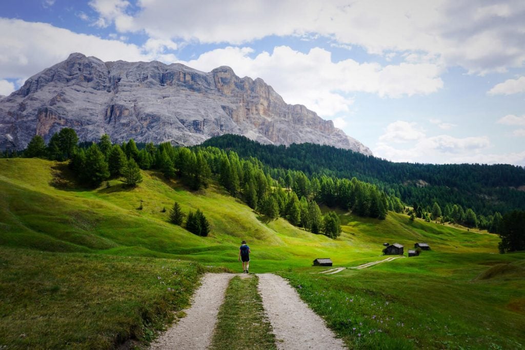
4. Armentara Meadows Trail
Some of the most beautiful Dolomites hiking trails are blissfully easy. If you’re in the mood for a gentle saunter across sloping meadows, this is for you.
Walking across Armentara meadows is like listening to a Rossini, or Donizetti opera. It’s light, happy, and effortless. That’s my last opera reference, promise!
The Armentara plateau is located on the western edge of Fanes-Senes-Braies Nature Park in Alta Badia.
To start this hike, head to the village of Badia in Alta Badia. Take the Santa Croce Chairlift followed by the La Crusc Chairlift to the La Crusc/Santa Croce/Heiligkreuz church.
From the pilgrimage church, follow trail 15 to Armentara, beneath the arresting rock faces of Mt. Sasso di Santa Croce. The trail slowly and continuously descends across rolling green pastures, peppered with hay huts.
For lunch, we recommend stopping at Űtia Ranch da André. From this hut, continue on trail 7a all the way down to Badia (1:15 hours).
Armentara Meadows Trail Stats
Where | Fanes-Senes-Braies Nature Park, South Tyrol
Trailhead | La Crusc Church
Cableway Ascent | Santa Croce Chairlift followed by the La Crusc Chairlift, Badia, Alta Badia
Distance | 9 km point-to-point
Time Needed | 3 hours
Difficulty | Easy
Where to Stay in Badia | Chalet Planvart (budget), or Hotel Badia Hill (luxury)
Learn More: Armentara Meadows Day Hike
5. Baita Segantini and Monte Castellaz Hike

Baita Segantini is an alpine pasture hut directly facing the Pale di San Martino mountain range in Trentino.
This spectacular Dolomites destination is easy to get to and as you can imagine very popular. While most people make a beeline for Baita Segantini, we recommend approaching the hut from Monte Castellaz. It’s a far more interesting approach, rewarding hikers with dramatic views of the Pala Group from multiple angles.
Starting at the Passo Rolle, a mountain pass high above San Martino di Castrozza, hike to the Capanna Cervino mountain hut. Proceed along the road in the direction of Baita Segantini for about 10 minutes. When you reach a signed intersection, turn left towards the solitary Monte Castellaz mountain.
The trail ascends to the summit of Monte Castellaz, marked by the Cristo Pensante (“Pensive Christ”) sculpture. Enjoy the various viewpoints, before starting the descent along the north flank of Castellaz.
When the trail levels, you’ll hike across grassy pastures towards the Pale di San Martino peaks. The trail ushers you to the perfectly positioned Baita Segantini hut.
From Baita Segantini, follow the road all the way down to Passo Rolle (45 minutes).
Baita Segantini Hiking Tips
Best Time of Day | Hike this trail in the late afternoon, or early evening, and watch the sunset at Baita Segantini.
Parking | There’s a large, free parking lot at Passo Rolle.
Extend the Hike | You can extend this hike by hiking to Val Venegia from Baita Segantini.
Baita Segantini Trail Stats
Where | Pale di San Martino Natural Park, Trentino
Trailhead | Passo Rolle
Distance | 9.2 km circuit
Time Needed | 3:00 – 3:30 hours
Difficulty | Easy
Where to Stay in San Martino di Castrozza | Residence Taufer (budget), Hotel Vienna (midrange), or Sayonara Nature & Wellness Hotel (luxury)
Learn More: Baita Segantini Hiking Guide
6. Sentiero Viel del Pan and Alta Via delle Cresta

Sentiero Viel del Pan (Viel dal Pan in Ladin, Bindelweg in German) is a hiking trail which crosses the southern slopes of the Padon chain and delivers unparalleled views of Marmolada, the highest mountain in the Dolomites.
Viel del Pan connects the Passo Pordoi mountain pass with Lago di Fedaia.
Rather than do a point-to-point hike, it’s possible to hike a circuit, by following the moderate Alta Via dell Cresta to Rifugio Viel del Pan, and returning to Passo Pordoi along the easy Viel del Pan.
This is a fantastic hike to do if you’re driving the Great Dolomites Road.
If you’re in the mood for an easy walk, you can forgo the Alta Via trail and simply walk the Viel del Pan out-and-back to Rifugio Viel del Pan.
Sentiero Viel del Pan Trail Stats
Where | Padon Chain, Trentino
Trailhead | Passo Pordoi
Distance | 7 km lollipop-circuit
Time Needed | 2:30 hours
Difficulty | Easy
Where to Stay at Passo Pordoi | Hotel Col di Lana (midrange)
Where to Stay in Val di Fassa | Locanda degli Artisti Art Hotel (luxury)
Learn More: Sentiero Viel del Pan
7. Sesto to Val Fiscalina Valley Walk

Val Fiscalina/Fischleintal is a gorgeous side valley of Valle di Sesto/Sextental, famous for its view of the Sesto/Sexten Sundial.
Many excursions into the Sexten mountains begin in Val Fiscalina, however the valley itself is a wonderful destination for leisurely walking.
For a nice, easy walk, we recommend hiking from the village of Sesto all the way through Val Fiscalina to Rifugio Fonda Valle/Talschlusshütte.
This is a great place to walk with children.
For a longer, more adventurous hike, you can extend the hike to Rifugio Locatelli, the mountain hut which stands north of the famous Three Peaks (Tre Cime di Lavaredo).
Val Fiscalina Trail Stats
Where | Sexten Dolomites, Alta Pusteria, South Tyrol
Trailhead | Sesto/Sexten
Distance | 12.2 km circuit
Time Needed | 3:15 hours
Difficulty | Easy
Where to Stay in Sesto | Caravan Park Sexten (budget), B&B Grüne Laterne – Lanterna Verde (budget), Hotel Royal (midrange), Bad Moos Dolomites Spa Resort (luxury)
Learn More: How to Visit Val Fiscalina
8. Santa Maddalena Panorama Trail

Santa Maddalena (St. Magdalena in German) is a village in Val di Funes (Villnösstal) in South Tyrol.
This small mountain village is home to the historic Santa Maddalena Church, which is one of the most popular photo motifs in the Dolomites. It’s also the start of an excellent panoramic hike.
This circuit trail weaves through meadows, pockets of forest, and historic farmsteads. There are fantastic views of the Odle Peaks and Val di Funes throughout.
Santa Maddalena Trail Stats
Where | Val di Funes, South Tyrol
Trailhead | Santa Maddalena Village
Distance | 9.5 km circuit
Time Needed | 3:30 hours
Difficulty | Easy
Where to Stay in Val di Funes | Appartements Pension Sonia (budget), Fallerhof (budget), Hotel Fines (midrange), Proihof (midrange), or Hotel Tyrol Dolomites slow living (luxury)
Learn More: Santa Maddalena Panorama Trail
9. Monte Specie

Monte Specie (Strudelkopf in German) is an easy-to-reach, panoramic summit in the Braies Dolomites, overlooking Tre Cime di Lavaredo, Cadini di Misurina, and the Cristallo Group.
This straightforward hike starts atop the Prato Piazza high plateau, above Braies Valley. The trail leads across mountain pastures to reach the summit of Monte Specie.
This is an ideal hiking destination for sunrise and/or sunset.
Monte Specie / Strudelkopf Trail Stats
Where | Braies/Prags Dolomites, South Tyrol
Trailhead | Prato Piazza Car Park
Distance | 8.8 km circuit
Time Needed | 2:50 hours
Difficulty | Easy
Where to Stay in Braies/Prags Valley | Garni Bergblick (budget), Moserhof Agriturismo Refugium (budget), or Farmhouse Hanslerhof (midrange)
Learn More: Monte Specie Hike
10. Cadini di Misurina Viewpoint Hike

The Cadini di Misurina mountains form the southernmost mountain group of the Sexten Dolomites.
There are many challenging hiking trails which bisect this range, including the Sentiero Bonacossa Trail, which we’ll talk about later in this Dolomites hiking guide.
However, to see the most staggeringly beautiful viewpoint of the Cadini mountains, you only have to walk 30 minutes from the Rifugio Auronzo car park, accessible by bus/car via the Rifugio Auronzo toll road.
It’s also possible to skip the toll road and walk to the Cadini di Misurina viewpoint from Lake Antorno. This 9.7 km out-and-back hike takes 3:40 hours to complete.
Cadini di Misurina Trail Stats
Where | Sexten Dolomites, Belluno
Trailhead | Rifugio Auronzo
Distance | 3.9 km out-and-back
Time Needed | 1:30 hours
Difficulty | Easy
Where to Stay | Albergo Chalet Lago Antorno (midrange) at Lake Antorno, or Grand Hotel Misurina (midrange) at Lake Misurina
Learn More: Cadini di Misurina Viewpoint Hike
11. Hans and Paula Steger Trail

The Hans and Paula Steger Trail is an easy, family-friendly hike atop Alpe di Siusi, starting in Compaccio.
The full circuit is 14.6 km, but you can shorten the hike, by taking the Almbus back to Compaccio from Saltria.
Much of the appeal of this trail lies in the dining opportunities along the way. We highly recommend eating lunch at Gostner Schwaige and/or Rauchhütte.
Hans and Paula Steger Trail Stats
Where | Alpe di Siusi, South Tyrol
Trailhead | Compaccio/Compatsch, Alpe di Siusi
Distance | 14.6 km lollipop-circuit
Time Needed | 4:30 hours
Difficulty | Easy
Where to Stay in Compaccio | Hotel Seelaus (midrange), Hotel Rosa ECO Alpine Spa Resort (luxury), or Alpina Dolomites (luxury)
Where to Stay in Castelrotto | Schgaguler Hotel (luxury), or Hotel Lamm (luxury)
Learn More: Hans and Paula Steger Trail
12. Alpe di Siusi Meadows Circuit Trail

Our Alpe di Siusi Meadows Trail combines the best part of the Alpe di Siusi-Monte Pana Trail with the best stretch of the Hans and Paula Steger Path. It stays on the plateau the whole time, ambling across rolling meadows. This route doesn’t scale mountains, or descend to the valley.
If you’re based in Val Gardena, this is the best way to see Alpe di Siusi/Seiser Alm in a few hours.
From the Ortisei-Alpe di Siusi gondola mountain station, follow trail 9 to Schgaguler Schwaige and all the way down to Saltria, a small settlement on the plateau.
Next, ascend the Hans and Paula Steger Trail (trail 30) in the direction of Compaccio/Compatsch, detouring to Gostner Schwaige and Rauchhütte along the way.
Complete the circuit to the Ortise-Alpe di Siusi gondola mountain station via Malga Sanon.
Alpe di Siusi Meadows Trail Stats
Where | Alpe di Siusi, South Tyrol
Trailhead | Oritisei-Alpe di Siusi gondola mountain station
Distance | 14.4 km circuit
Time Needed | 4:25 hours
Difficulty | Easy
Where to Stay in Ortisei | Appartmenthotel Residence Elvis (budget), Hotel Hell (midrange), Alpin Garden Luxury Maison & SPA – Adults Only (luxury), or Hotel Angelo Engel (luxury)
Learn More: Alpe di Siusi Meadows Hike
Moderate Day Hikes in the Dolomites
13. Lago di Braies to Hochalpenkopf
The circuit hike from Lago di Braies to the summit of Hochalpenkopf/Cima dei Colli Alti is perfect for anyone seeking a full-day adventure in the Braies/Prags Dolomites. Though this trail presents no technical difficulty, it is very long (16.9 km total) and requires stamina.
From Hotel Lake Braies, follow the circuit trail around the lake counter-clockwise. When you get to the opposite end of the lake, follow signs to Malga Foresta/Grünwaldalm. After passing this alpine pasture hut, you’ll continue walking through the Val di Foresta/Grünwaldtal valley.
The trail eventually ascends to the remote Ütia Fojadora mountain pasture. From here, the trail continues across high-alpine pastures to Hochalpenkopf Peak. The views are spectacular. The trail ends with a steep (but manageable descent) back to Lake Braies.
Hochalpenkopf Trail Stats
Where | Fanes-Sennes-Brais Nature Park, South Tyrol
Trailhead | Lago di Braies, Valle di Braies/Pragser Tal Valley
Distance | 16.9 km circuit
Time Needed | 8 hours with breaks
Difficulty | Moderate
Where to Stay in Braies/Prags Valley | Garni Bergblick (budget), Moserhof Agriturismo Refugium (budget), or Farmhouse Hanslerhof (midrange)
Where to Stay in Monguelfo/Welsberg | Hotel Christof (luxury) or Silentium Dolomites Chalet (luxury)
Trail Guide: Lago di Braies to Hochalpenkopf
14. Sassolungo Circuit Trail

The Sassolungo (Langkofel in German, Saslonch in Ladin) Group is a compact mountain group which is located between Val Gardena and Val di Fassa.
This group is named after its most prominent peak, Sassolungo (3181 meters), which is the 9th highest peak in the Dolomites.
A long circuit trail wraps around the entire mountain group. It’s a 17.7 km trail that takes 6:15 hours to complete. Though it’s not a difficult trail, it’s quite long.
Along the way, hikers are rewarded with views of Marmolada, the Catinaccio-Sciliar Mountains, Alpe di Siusi, the Puez-Odle Mountains, and the Sella Group.
Sassolungo Loop Trail Stats
Where | Sassolungo Group, South Tyrol and Trentino
Trailhead | Passo Sella
Distance | 17.7 km circuit
Time Needed | 6:15 hours
Difficulty | Moderate
Where to Stay in Selva | Residence Antares (budget), Hotel Garni Morene (budget), Hotel Freina (midrange), or Linder Cycling Hotel (luxury)
Learn More: Sassolungo Circuit Trail
15. Vallunga Valley and Val de Chedul

Vallunga and Val de Chedul are two alpine valleys in Puez-Odle Nature Park.
This circuit hike links these two valleys with the Puez-Odle Altopiano.
This is a stunning route, which takes you to some of the quieter areas of the Val Gardena Dolomites.
Vallunga Circuit Trail Stats
Where | Puez-Odle Nature Park, South Tyrol
Trailhead | Parcheggio Vallunga Car Park
Distance | 16.1 km circuit
Time Needed | 6 hours
Difficulty | Moderate
Where to Stay in Selva | Residence Antares (budget), Hotel Garni Morene (budget), Hotel Freina (midrange), or Linder Cycling Hotel (luxury)
Learn More: Vallunga and Val de Chedul
16. Passo Giau to Monte Mondeval

Mondeval is a bowl-shaped plateau in the municipality of San Vito di Cadore within the Dolomites UNESCO System Pelmo – Croda da Lago.
The Mondeval plateau harbors many treasures including the archaeological burial site of Mondeval de Sora, the tiny Lago delle Baste lake, and the Monte Mondeval panoramic peak. We love Mondeval because of the views of Monte Pelmo, Lastoni di Formin, and Croda da Lago.
This circuit trail takes you to all the best places atop Mondeval, starting at the gorgeous Passo Giau mountain pass.
Mondeval Trail Stats
Where | Ampezzo Dolomites, Belluno
Trailhead | Passo Giau
Distance | 12.8 km lollipop-circuit
Time Needed | 5 hours
Difficulty | Moderate
Where to Stay in Pocol | Hotel Piccolo Pocol (budget)
Where to Stay in Cortina d’Ampezzo | Hotel Meuble Oasi (budget), Hotel Ambra Cortina D’Ampezzo (midrange), Camina Suite & Spa (luxury), Hotel de Len (luxury), or Dolomiti Lodge Alvera (luxury)
Trail Guide: Passo Giau to Monte Mondeval
17. Monte Pic Summit

Monte Pic/Picberg is a panoramic mountain in the Val Gardena Dolomites, high above Ortisei and Santa Cristina. You can easily combine Monte Pic with the Seceda Ridgeline, which is an excellent option when the cableways aren’t operating.
This is one of our favorite day hikes in the Dolomites, because it gives you a great overview of the Odle Group and the Seceda Alp. The trail connects a number of Val Gardena alpine pasture huts and refuges, which make for delightful rest stops along this gorgeous tour.
The highlight of this Dolomites hike is the view from Monte Pic and the descent to the Baita Seurasas alpine pastures, one of the best-kept secrets in Val Gardena.
Monte Pic Trail Stats
Where | Puez-Odle Nature Park, South Tyrol
Trailhead | Cristauta/Praplan Car Park, Santa Cristina, Val Gardena
Distance | 13.9 km circuit
Time Needed | 6 hours
Difficulty | Moderate / Moderately-Difficult
Where to Stay in Santa Cristina | Smart Hotel Saslong (budget), Hotel Cristallo (midrange) Charme Hotel Uridl (midrange), Dorfhotel Beludei (luxury)
Learn More: Monte Pic Day Hike
18. Rifugio Genova and the Val di Funes Alpine Pastures

Rifugio Genova/Schlüterhütte is a mountain hut in Puez-Odle Nature Park. Starting at the Zannes Car Park (like the Adolf Munkel Trail) in Val di Funes, follow trail 6 in the direction of Furcella de Furcia/Kreuzjoch. This trail leads across quiet meadows and ascends steadily to the Kreuzjoch saddle.
This corner of Puez-Geisler Nature Park is delightfully quiet.
With steady views of the Puez and Fanes mountains, continue along trail 5 and then trail 3 to Rifugio Genova. Sasso di Santa Croce/Mount Heiligenkreuzkofel rises above Val Badia like a ship at the crest of a wave.
From Rifugio Genova, continue to Malga Gampen/Gampenalm (30 minutes) and then to Zans/Zannes (50 minutes). As you wander across the Val di Funes alpine pastures, you’ll be treated to yet another satisfying vista of the Geisler peaks.
Rifugio Genova Trail Stats
Where | Puez-Odle Nature Park, South Tyrol
Trailhead | Zannes/Zan Car Park in Val di Funes, South Tyrol
Distance | 11 km circuit
Time Needed | 4:30 hours
Difficulty | Moderate
Where to Stay in Val di Funes | Appartements Pension Sonia (budget), Fallerhof (budget), Hotel Fines (midrange), Proihof (midrange), or Hotel Tyrol Dolomites slow living (luxury)
Learn More: Rifugio Genova Day Hike
19. Sass de Putia Circuit Hike

Sass de Putia/Peitlerkofel is a solitary two-headed mountain in Puez-Odle Nature Park.
A highly enjoyable hiking path circuits Sass de Putia, weaving through forest and across alpine pastures.
From the Passo delle Erbe mountain pass, follow the road towards Sass de Putia. When you reach the alpine pastures at the base of the mountain’s northern slopes (20 minutes), turn right and follow signs to the Forcela de Pütia/Peitlerscharte mountain saddle.
The ascent to the saddle is the hardest part of the hike. It’s straightforward, but continuously uphill.
From here, the trail descends across romantic alpine pastures and continues to Ütia Vaciara and Ütia de Göma, two huts directly on the trail. We had a wonderful lunch at Ütia de Göma.
Tips for Hiking around Sass de Putia
Where to Stay | Stay the night at Ütia de Börz, an upscale mountain refuge, located directly at the trailhead. Their food is outstanding.
Extend the Hike | You can combine this circuit hike with the summit of Sass de Putia (Grade A/B via ferrata). Alternatively, it’s possible to detour to Rifugio Genova from the Forcela de Pütia saddle.
Sass de Putia Circuit Trail Stats
Where | Puez-Odle Nature Park, South Tyrol
Trailhead | Passo delle Erbe, Alta Badia
Distance | 12.8 circuit
Time Needed | 4 hours
Difficulty | Moderate
Where to Stay at Passo delle Erbe | Ütia de Börz (midrange)
Where to Stay in Val di Funes | Appartements Pension Sonia (budget), Fallerhof (budget), Hotel Fines (midrange), Proihof (midrange), or Hotel Tyrol Dolomites slow living (luxury)
Learn More: Sass de Putia Trail Guide
20. Rifugio Gardenacia – Gherdenacia Plateau – Rifugio Puez

Rifugio Puez (Puez Hütte, Ütia de Puez) and Rifugio Gardenacia are two mountain huts in Puez-Odle Nature Park.
This point-to-point Dolomites hike begins with the Gardenaccia Chairlift ascent from the village of La Villa in Val Badia. From the mountain station, follow trail 5 to Rifugio Gardenacia (50 minutes), a cheerful mountain hut facing Fanes with a dozen resident Haflinger horses.
Continue in the direction of Rifugio Puez on trail 5/11 and then trail 15. Trail 15 cuts across the vast and desolate Gherdenacia alpine plateau, which looks like a stone desert.
After ascending to Forcella de Gherdenacia, continue towards the cone-shaped Col dala Sone (2663 m) mountain. It’s another 40 minutes to Puez Hütte. Shortly before arriving at the hut, there are some impressive views of Vallunga/Langental Valley.
From Puez mountain hut, we followed trail 2 (direction: Colfosco) to Forcella de Ciampëi Scharte and then trail 4 followed by 4A to Corvara. Given the long descent (trail 4A), we think it’s better to end in Colfosco.
Tips for Hiking across the Gherdenacia Plateau
Trail Variations | You could make this a circuit hike. When trail 4 intersects with trail 7, follow trail 7 to Forcella del Sassongher and then trail 5 back to Rifugio Gardenacia.
There are many ways to modify this hike. For example, you can hike down to Vallunga/Langental valley (trail 14) and end your hike in Selva di Val Gardena. You could also end the hike at Passo Gardena via Sas Ciampac (Trail 2, 2A).
Gherdenacia Plateau Trail Stats
Where | Puez-Odle Nature Park
Trailhead | Gardenaccia Chairlift Mountain Station
Cableway Ascent | Gardenaccia Chairlift, La Villa, Alta Badia
Ending Point | Corvara or Colfosco, Alta Badia
Distance | 13 km point-to-point
Time Needed | 6 hours
Difficulty | Moderate
Where to Stay in La Villa | Ciasa Agreiter (budget), Hotel La Majun (luxury), Hotel Cristallo – Wellness Mountain Living (luxury), or Hotel Ciasa Soleil (luxury)
Learn More: Rifugio Puez Day Hike
21. Sass da Ciampac

Sass da Ciampac is the highest peak in the Cir Group, which is part of the Puez mountain range.
The hike to Sass da Ciampac is a moderate one, beginning at Passo Gardena, the mountain pass connecting the valleys of Val Gardena and Val Badia. Along the way to Sass da Ciampac, you’ll cross the Cir Peaks, drop into Val de Chedul valley, and make a counter-ascent to Forcella de Crespeina, the gateway to the Crespëina High Plateau.
The ascent to Sass da Ciampac is straightforward and rewards you with wonderful views of Val Badia, the Sella Group, and the Puez Peaks. The descent to Crespëina plateau and Lake Crespëina is more difficult, because of the scree and slippery terrain.
Start early and detour to Rifugio Puez for lunch.
Sass de Ciampac Trail Stats
Where | Puez-Odle Nature Park, South Tyrol
Trailhead | Passo Gardena
Distance | 14.7 km lollipop-circuit
Time Needed | 6 hours
Difficulty | Moderate
Where to Stay in Selva | Residence Antares (budget), Hotel Garni Morene (budget), Hotel Freina (midrange), or Linder Cycling Hotel (luxury)
Learn More: Sass da Ciampac Hike
22. Rifugio Nuvolau and Cinque Torri

Rifugio Nuvolau is a rustic mountain refuge planted on the summit Monte Nuvolau at 2575 meters.
A few years ago, we overnighted here when we trekked the Alta Via 1 long distance trail. But, there’s no need to embark on a multi-day hike in order to visit this iconic Rifugio.
Given it’s proximity to the Cinque Torri chairlift, Rifugio Nuvolau is relatively easy to get to.
However, a more interesting approach starts at Col Gallina, near Passo Falzarego.
This short circuit trail links together some of the most popular destinations in the Averau-Nuvolau Group including Lago di Lìmedes, Rifugio Averau, Rifugio Scoiattoli, and the Cinque Torri rock towers.
Cinque Torri is also an open-air museum, where you can walk through a maze of restored trenches and shelters dating back to the First World War.
Cinque Torri Trail Stats
Where | Nuvolau-Averau Group, Belluno
Trailhead | Col Gallina
Distance | 9.6 km circuit
Time Needed | 3:45 hours
Difficulty | Moderate
Where to Stay in Cortina d’Ampezzo | Hotel Meuble Oasi (budget), Hotel Ambra Cortina D’Ampezzo (midrange), Camina Suite & Spa (luxury), Hotel de Len (luxury), or Dolomiti Lodge Alvera (luxury)
Learn More: Rifugio Nuvolau and Cinque Torri Hike
Moderately Difficult Hikes in the Dolomites
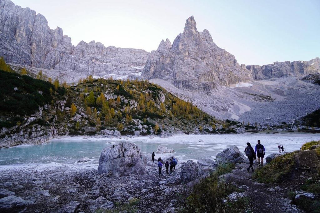
23. Lago di Sorapis Hike
Lago di Sorapis is a glacial lake in the Sorapiss Group in the province of Belluno.
Set in a natural amphitheater and ringed by forest and rock, Lago di Sorapis enchants with its milky-turquoise hue and imposing mountain backdrop.
The easiest way to get to Lake Sorapis is from the Passo Tre Croci mountain pass, located about halfway between Cortina d’Ampezzo and Lake Misurina.
From Passo Tre Croci, follow trail 215 in the direction of Rifugio Vandelli. Trail 215 is initially wide and level. After about an hour, the trail becomes increasingly steep and narrow. There are some exposed sections, secured with cables.
Shortly before arriving at the lake, you can detour to the Rifugio Vandelli mountain hut.
Most hikers will return to Passo Tre Croci along the same route. However, there’s an exciting alternative route via the Forcella Marcuoira saddle. This route is best undertaken by experienced alpine hikers, who are confident in steep rocky terrain.
Lago di Sorapis Hiking Tips
When to Hike | Avoid hiking to Lago di Sorapis in July and August. This is a very popular Dolomites day hike and your experience will be greatly impacted by the amount of people on this trail.
Follow the Rules | Swimming is not allowed in Lake Sorapis and camping is not allowed near Lake Sorapis.
Lake Sorapis Trail Stats
Where | Ampezzo Dolomites, Belluno
Trailhead | Passo Tre Croci, halfway between Cortina d’Ampezzo and Lake Misurina
Distance | 13.2 km circuit
Time Needed | 5:10 hours
Difficulty | Difficult
Where to Stay at Passo Tre Croci | B&B Hotel Passo Tre Croci Cortina (midrange)
Where to Stay in Cortina d’Ampezzo | Hotel Meuble Oasi (budget), Hotel Ambra Cortina D’Ampezzo (midrange), Camina Suite & Spa (luxury), Hotel de Len (luxury), or Dolomiti Lodge Alvera (luxury)
Learn More: Lago di Sorapis Trail Guide
24. Tullen Summit

Tullen (2653 m) is the highest summit in the Odle d’Eores/Aferer Geisler Group.
From the Zannes/Zans trailhead in Val di Funes, you’ll follow the lesser known Oberer Herrensteig (“Upper Men’s Trail”) and eventually the Günther Messner Steig to Tullen peak.
This is an excellent hike to do, when you’ve already hiked the Adolf Munkel Trail and you want to explore more remote and quiet trails above Val di Funes.
Tullen Trail Stats
Where | Puez-Odle Nature Park, South Tyrol
Trailhead | Zannes/Zans Car Park in Val di Funes
Distance | 12.6 km out-and-back
Time Needed | 7 hours
Difficulty | Moderately Difficult
Where to Stay in Val di Funes | Appartements Pension Sonia (budget), Fallerhof (budget), Hotel Fines (midrange), Proihof (midrange), or Hotel Tyrol Dolomites slow living (luxury)
Trail Guide: Tullen Peak Hike
25. Alpe di Siusi – Rifugio Bolzano – Rifugio Alpe di Tires

Alpe di Siusi (Seiser Alm in German, Mont de Sëuc in Ladin) is the largest high alpine pasture in Europe. The plateau is furrowed with walking and biking paths, leading towards the Sassolungo Group, Catinaccio/Rosengarten mountains, and Sciliar/Schlern massif.
This epic circuit trail crosses the pastures of Alpe di Siusi, ascends to Rifugio Bolzano atop the Sciliar/Schlern plateau, traverses the plateau, descends to Rifugio Alpe di Tires (between the Sciliar and Catinaccio mountains), and then returns to Alpe di Siusi via Forcella Denti di Terrarossa.
Rifugio Bolzano Trail Stats
Where | Alpe di Siusi and Schlern-Rosengarten Nature Park, South Tyrol
Trailhead | Compaccio/Compatch, Alpe di Siusi/Seiser Alm
Distance | 21.6 km circuit
Time Needed | 8 hours
Difficulty | Moderately difficult because of the length
Where to Stay atop Alpe di Siusi | Hotel Seelaus (midrange), Hotel Steger-Dellai (luxury), or Alpina Dolomites (luxury)
Where to Stay in Castelrotto | Hotel Lamm (luxury), or Schgaguler Hotel (luxury)
Trail Guide: Alpe di Siusi – Rifugio Bolzano Circuit
26. Croda da Lago Circuit Trail

Croda da Lago is a small mountain chain in the Ampezzo Dolomites.
The circuit trail around Croda da Lago is a spectacular adventure, filled with captivating scenery and varied terrain. The trail (#437) begins at the Ponte di Rocurto trailhead along the SP638 road, between Pocol (Cortina d’Ampezzo) and Passo Giau.
You’ll initially ascend through forest to Lago Federa and Rifugio Croda da Lago. The trail continues to Forcella Ambrizzola saddle, the gateway to the sprawling Mondeval pasture. Turning towards the titanic Lastoni di Formin, the path steadily ascends to Forcella di Formin, the highest point of the hike.
From the Formin saddle, the trail leads you down the fields of boulders to Val Formin valley and then rejoins trail 437 back to Ponte de Rocurto.
Croda da Lago Trail Stats
Where | Ampezzo Dolomites, Belluno
Trailhead | Ponte di Rocurto
Distance | 13.1 km circuit
Time Needed | 5 hours
Difficulty | Moderately Difficult
Where to Stay in Pocol | Hotel Piccolo Pocol (budget)
Where to Stay in Cortina d’Ampezzo | Hotel Meuble Oasi (budget), Hotel Ambra Cortina D’Ampezzo (midrange), Camina Suite & Spa (luxury), Hotel de Len (luxury), or Dolomiti Lodge Alvera (luxury)
Trail Guide: Croda da Lago Circuit Trail
27. Tofana di Rozes Circuit Trail

Tofana di Rozes is one of the most photographed mountains in the Ampezzo Dolomites. You can relish the views of this significant mountain in the Tofane Group from Passo Giau, Passo Falzarego, Lago Limides, Rifugio Lagazuoi, Rifugio Nuvolau, Cinque Torri and other iconic spots around Cortina d’Ampezzo.
Very few people know that there’s an excellent hiking trail that wraps around Tofana di Rozes, starting at Rifugio Dibona.
The loop cuts across the southern slopes of Tofana di Rozes, ascends effortlessly to the Forcella Col dei Bos saddle, continues towards the Travenanzes valley, and then steeply ascends the rugged Majarié glacial cirque to Rifugio Giussani. From the Giussani hut, the Tofana di Rozes trail descends back to Rifugio Dibona along WWI paths.
Tofana di Rozes Circuit Trail Stats
Where | Dolomiti D’Ampezzo Natural Park, Belluno
Trailhead | Rifugio Dibona
Distance | 11.9 km circuit
Time Needed | 5:30 hours
Difficulty | Moderately Difficult
Where to Stay in Cortina d’Ampezzo | Hotel Meuble Oasi (budget), Hotel Ambra Cortina D’Ampezzo (midrange), Camina Suite & Spa (luxury), Hotel de Len (luxury), or Dolomiti Lodge Alvera (luxury)
Trail Guide: Tofana di Rozes Circuit Trail
28. Gaisl High Trail
The Gaisl High Trail leads across the northern slopes and cirques of the Croda Rossa d’Ampezzo/Hohe Gaisl massif in Fannes-Sennes-Braies Nature Park.
This is a beautiful hike starting atop the Prato Piazza plateau in the Braies Dolomites.
Most of the hike is quite moderate, but there is one secured passage which may be troublesome for those that dislike exposure and narrow ledge paths.
Gaisl High Trail Stats
Where | Fanes-Sennes-Braies Nature Park, South Tyrol
Starting Point | Prato Piazza Car Park
Ending Point | Ponticello
Distance | 12 km point-to-point
Time Needed | 4:10 hours
Difficulty | Moderately Difficult
Where to Stay in Braies/Prags Valley | Garni Bergblick (budget), Moserhof Agriturismo Refugium (budget), or Farmhouse Hanslerhof (midrange)
Learn More: Gaisl High Trail
Challenging Hikes in the Dolomites
29. Torre dei Scarperi Circuit Trail

The hike around Torre dei Scarperi (Schwabenalpenkopf in German) is a stunning and interesting circuit hike in the Sesto/Sexten Dolomites.
This day hike starts in Val Campo di Dentro (Innerfeldtal in German), a side valley of Sesto/Sexten Valley. It connects Rifugio Tre Scarperi/Drei Schuster Hütte with Rifugio Locatelli/Dreizinnenhütte.
From the Antoniusstein Car Park, the trail leads to the head of Val Campo di Dentro and then ascends around the western flank of Monte Mattina/Morgenkopf to reach the narrow Passo Grande dei Rondoi saddle.
After a short secured scramble, the path crosses the grassy Schwaben Alm and wraps around the southeastern shoulder of Torre dei Scarperi/Schwabenalpenkopf.
To detour to Rifugio Locatelli, skirt the Torre di Toblin/Toblinger Noten and hug the base of Sasso di Sesto/Sextener Stein.
The descent to Val Campo di Dentro is spectacular. Though it’s long, it’s well-graded. The trail hugs the eastern flank of Monte Mattina/Morgenkopf (trail 105) and rejoins the valley trail to return to Rifugio Tre Scarperi.
Torre dei Scarperi Trail Stats
Where | Sexten Dolomites
Trailhead | Antoniusstein Car Park in Val Campo di Dentro
Distance | 16.7 km lollipop-circuit
Time Needed | 6:20 hours
Difficulty | Moderately-Difficuly
Where to Stay in Sesto | Caravan Park Sexten (budget), B&B Grüne Laterne – Lanterna Verde (budget), Hotel Royal (midrange), Bad Moos Dolomites Spa Resort (luxury)
Where to Stay in San Candido | Naturhotel Leitlhof (luxury)
Learn More: Torre dei Scarperi Circuit Trail
30. Resciesa Plateau to Seceda Ridgeline

The Seceda ridgeline can be approached in a number of ways. The easiest way is via the Ortisei-Furnes-Seceda cableways. However, a more exciting route is from the Resciesa plateau.
Starting in the village of Ortisei in Val Gardena, take the Resciesa funicular up to the Resciesa plateau. From the mountain station, follow trail 35 to Malga Brogles.
As you hike across the Resciesa Alp on a pleasantly flat and easy walking path, you’re also walking towards the Odle/Geisler Peaks. The views are fantastic.
A few years ago, it was possible to ascend from Malga Brogles to Seceda via the Panascharte. However, this direct trail is closed for safety reasons due to a rockfall.
If you want to do this trail, you must ascend to Seceda via Furcela De Mesdi/Mittagsscharte. It’s a more strenuous tour, but absolutely worthwhile. Only undertake it of you’re confident hiking in scree and loose rocks.
Depending on where you’re staying in Val Gardena, you can either descend to Ortisei via Ortisei – Furnes – Seceda cableways or to Selva di Val Gardena via the Col Raiser gondola.
Resciesa to Seceda Trail Stats
Where | Puez-Odle Nature Park, South Tyrol
Trailhead | Resciesa Funicular Mountain Station
Cableway Ascent | Resciesa Funicular, Ortisei, Val Gardena
Cableway Descent | Seceda Cableway Mountain Station, or Col Raiser Gondola Mountain Station
Distance | 13.8 km point-to-point
Time Needed | 5:20 hours
Difficulty | Difficult
Where to Stay in Ortisei | Appartmenthotel Residence Elvis (budget), Hotel Hell (midrange), Alpin Garden Luxury Maison & SPA – Adults Only (luxury), or Hotel Angelo Engel (luxury)
Learn More: Resciesa to Seceda Day Hike
31. Col dala Pieres Summit Hike

This excellent Dolomites hiking trail is for confident hikers who crave intoxicating views of the Sella Group, Sassolungo Group, and the Odle Peaks. The hike to Col dala Pieres summit begins with a Col Raiser cableway ascent from Selva di Val Gardena.
From the Col Raiser mountain station, follow the easy trail 4 to Rifugio Firenze/Regensburger Hütte.
From the mountain hut, descend along trail 1, for a few minutes, until you locate the 17B trail intersection, on your left. Ascend to Forcella Piza/Pizascharte along a steep and narrow, rock-laden gorge. Part of the trail is secured with wooden planks and cables.
Atop Stevia plateau, wonderful views extend in every direction. We recommend detouring to Rifugio Stevia, before backtracking and conquering Col dala Pieres. As you descend to the hut across the Stevia alpine pastures, you’ll likely share the path with grazing sheep.
After a nice break at Stevia hut, ascend to Col dala Pieres (trail 17) and then start the somewhat challenging descent to Forcella Forces de Sieles. From here, follow trail 2 back to Rifugio Firenze and then to the Col Raiser mountain station.
Col dala Pieres Trail Stats
Where | Puez-Odle Nature Park, South Tyrol
Trailhead | Col Raiser Gondola Mountain Station
Cableway Ascent/Descent | Col Raiser Gondola, Selva di Val Gardena, Val Gardena
Distance | 13.7 km circuit
Time Needed | 6 – 7 hours
Difficulty | Difficult
Where to Stay in Santa Cristina | Smart Hotel Saslong (budget), Hotel Cristallo (midrange) Charme Hotel Uridl (midrange), Dorfhotel Beludei (luxury)
Learn More: Col dala Pieres Trail Guide
32. Cima Pisciadù Summit Hike

This is one of the best hikes in the Dolomites for experienced hikers. This point-to-point (or circuit) trail begins at Passo Gardena, the mountain pass between Val Badia and Val Gardena.
From Gardena Pass, follow the lovely balcony trail 666 to Val Setus, a steep sloping valley, defined by crumbling rocks and scree. The ascent up Val Setus to Lake Pisciadù is steep and partially secured (no equipment necessary).
At Lake Pisciadù, there’s a mountain hut, which is the only place to eat along the route.
If you feel energized (and the hike has been very manageable so far), you can continue one hour to the summit of Cima Pisciadù, for more thrilling views. This stretch entails free scrambling.
From the summit, return to the lake along the same route. The hike continues down to Val de Mezdi and ultimately back to Passo Gardena, or to Colfosco / Corvara (two villages in Alta Badia).
Pisciadù Trail Stats
Where | Sella Group, South Tyrol
Starting Point | Passo Gardena
Ending Point | Corvara
Distance | 12.4 km point-to-point (circuit also possible)
Time Needed | 5 hours
Difficulty | Difficult
Where to Stay in Colfosco | Pension Mirandola (budget), Crëp Sella (midrange), or Hotel Kolfuschgerhof (luxury)
Where to Stay in Corvara | Hotel Gran Fanes (midrange), Sporthotel Panorama (midrange), Hotel La Perla: The Leading Hotels of the World (luxury) or Hotel Col Alto (luxury)
Learn More: Cima Pisciadù Hiking Guide
33. Vajolet Towers

The Vajolet Towers are six summits in the Catinaccio/Rosengarten Dolomites. These majestic towers are a worthy day hiking destination in the Dolomites if you’re staying in Val di Fassa, or in Val d’Ega.
We started this hike with the Paolina Chairlift in Carezza, because we were staying at Sporthotel Alpenrose. You can also shave off 2-hours of this hike, by ascending to Kölner Hütte via the Laurin II Chairlift from Nova Levante.
From the Paolina chairlift mountain station, we followed the gentle path to Kölnerhütte.
From the Kölner mountain hut, there are two ways to hike to the Vajolet towers. You can either take the hiking path via Passo delle Coronelle/Tschagerjoch or the Santner Via Ferrata route. We highly recommend the via ferrata route. It’s more interesting.
If you take the via ferrata route up, you’ll plateau at Santnerpass. The view of Gartlhütte, the mountain hut at the foot of the towers, is glorious. Descend to Kölner hütte via the Passo delle Coronelle/Tschagerjoch hiking path.
We hiked here as part of our 3-day hut-to-hut hike across the Rosengarten. You can find out more details about the Santner via ferrata ascent and the trek in our 3-day Rosengarten Trekking Guide.
Vajolet Towers Hiking Tips
Via Ferrata Equipment | You can rent via ferrata equipment at the sports shop at Sporthotel Alpenrose.
When to Start | Start this hike early, to avoid guided tour groups along the Santner via ferrata.
Vajolet Towers Trail Stats
Where | Sciliar-Catinaccio Nature Park / Schlern-Rosengarten Nature Park, South Tyrol
Trailhead | Paolina Chairlift Mountain Station
Cableway Ascent/Descent | Paolina Chairlift, Carezza/Karersee, Val d’Ega/Eggental
Distance | 13.8 km lollipop-circuit
Time Needed | 6-7 hours
Difficulty | Difficult
Where to Stay in Carezza | Sporthotel Passo Carezza (midrange), Moseralm Dolomiti Spa Resort (luxury)
Where to Stay in Nova Levante | Hotel B&B Pardeller (budget), Tyrol Living & Cafe (luxury)
34. Val Venegia to Rifugio Mulaz

This Dolomites day hike is an excellent introduction to the Pale di San Martino range. It combines charming alpine pasture huts, dreamy valleys, high alpine Rifugios, scree slopes, rolling meadows and larch forests into one divine hiking tour.
The hike begins with any easy stroll through Val Venegia to the Malga Venegiota alpine pastures. From Malga Venegiota, you’ll start the ascent to Passo Mulaz and Rifugio Mulaz.
From the Mulaz hut, the loop trail continues to Passo dei Fochet and Passo di Venegiota, showcasing some of the most varied and interesting views of the Pala Group, Civetta, and so many other mountains I can’t even begin to name.
Rifugio Mulaz Trail Stats
Where | Pale di San Martino Natural Park, Trentino
Trailhead | Malga Venegia, Val Venegia
Distance | 12.6 km lollipop-circuit
Time Needed | 6:30 – 7 hours
Difficulty | Moderately Difficult – Difficult
Where to Stay in San Martino di Castrozza | Residence Taufer (budget), Hotel Vienna (midrange), or Sayonara Nature & Wellness Hotel (luxury)
Learn More: Rifugio Mulaz Circuit Hike
35. Around Pala di San Martino: Rifugio Rosetta to Rifugio Pradidali

This classic Dolomites day hike wraps around Pala di San Martino, a mountain in the central Pala Group. With the assistance of two cableways (Col Verde and Rosetta), you’ll arrive at the Altopiano delle Pale di San Martino, a vast lunar landscape.
Descend to the Rifugio Rosetta mountain hut straight ahead (10 minutes). From here, we recommend hiking counter-clockwise around Pala di San Martino. Follow signs to Passo di Ball and Rifugio Pradidali.
This hike traverses difficult terrain, requiring surefootedness and some scrambling.
Pala di San Martino Circuit Hiking Tips
Special Equipment | This route involves a rather lengthy secured passage along an exposed ledge. Though via ferrata equipment isn’t necessary, we highly recommend climbing gloves, which make grasping steel cables more comfortable.
When to Hike | You can hike this trail from late June until mid-October, weather permitting. If you’re hiking here between late September and mid-October, the cableways are only open on the weekend.
Pala di San Martino Trail Stats
Where | Pale di San Martino Natural Park, Trentino
Trailhead | Rosetta Cableway Mountain Station
Cableway Ascent/Descent | Col Verde Gondola and Rosetta Cableway, San Martino di Castrozza
Distance | 12.1 km Circuit
Time Needed | 6 hours
Difficulty | Difficult and technically demanding
Where to Stay in San Martino di Castrozza: Residence Taufer (budget), Hotel Vienna (midrange), or Sayonara Nature & Wellness Hotel (luxury)
Learn More: Rifugio Rosetta to Rifugio Pradidali Hiking Guide
36. Capanna Alpina – Rifugio Fanes – La Villa

You can do a moderate out-and-back hike to Fanes Hütte, starting and ending at the Capanna Alpina mountain hut. There’s a paid parking lot (cash only) directly at the hut.
A more challenging option is to extend the hike to Forcella de Medesc (trail 12) and ultimately down the Val de Medesc valley to La Villa in Val Badia. The descent from the Forcella de Medesc is demanding, requiring you to skillfully hike down steep scree slopes. We were pretty exhausted by the end of the day.
Rifugio Lavarella is home to the highest brewery in Europe. Make sure to grab a beer with lunch.
If you stay in La Villa, like we did, take bus line 465 in the direction of Passo Falzarego to Sciaré. From the bus stop, it’s a 20-minute walk to the Capanna Alpine mountain hut.
Capanna Alpina – La Villa Trail Stats
Where | Fanes-Senes-Braies Nature Park, South Tyrol
Trailhead | Sciaré Bus Stop or Capanna Alpina, San Cassiano, Alta Badia
Ending Point | La Villa, Alta Badia
Distance | 20 km point-to-point
Time Needed | 8 hours
Difficulty | Demanding
Where to Stay in San Cassiano | Lagacio Hotel Mountain Residence (luxury)
Where to Stay in La Villa | Ciasa Agreiter (budget), Hotel La Majun (luxury), Hotel Cristallo – Wellness Mountain Living (luxury), or Hotel Ciasa Soleil (luxury)
Learn More: Rifugio Fanes Trail Guide
37. Cima della Vezzana Summit

Cima della Vezzana is the highest mountain in the Pale di San Martino range. You can summit Cima della Vezzana in 3 hours from the Rosetta cableway mountain station.
This is the most challenging hike in our Dolomites hiking guide. It’s a taxing route, which should only be undertaken by the most experienced alpine hikers.
Cima della Vezzana Trail Stats
Where | Pale di San Martino Natural Park, Trentino
Trailhead | Rosetta Cableway Mountain Station
Cableway Ascent/Descent | Col Verde Gondola and Rosetta Cableway, San Martino di Castrozza
Distance | 13.8 km out-and-back
Time Needed | 6 hours
Difficulty | Extremely Challenging. Technically demanding.
Where to Stay in San Martino di Castrozza | Residence Taufer (budget), Hotel Vienna (midrange), or Sayonara Nature & Wellness Hotel (luxury)
Learn More: Cima della Vezzana Hiking Guide
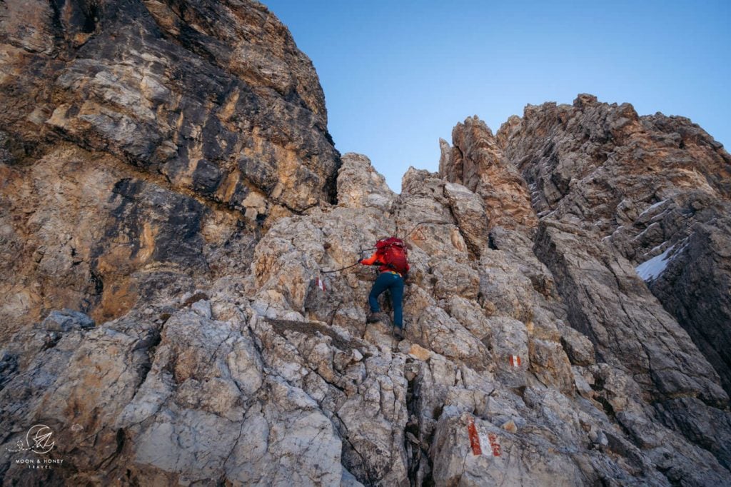
Sentiero Attrezzato Hikes in the Dolomites
These hikes are semi-secured with fixed cables and other climbing aids. A Sentiero Attrezzato is something between a regular hiking trail and a via ferrata. Though in most cases a full via ferrata kit isn’t necessary, a climbing helmet is advised.
38. Gran Cir

Gran Cir is a prominent peak in the Cir Group (Pizes de Cir in Ladin, Gruppo del Cir in Italian, Cirspitzen in German) within Puez-Odle Nature Park.
This popular summit is easily accessible from Passo Gardena/Grödner Joch.
From the mountain pass, it takes 1:30 hours to hike to the summit of Gran Cir.
The rewards are many. Atop Gran Cir, you’ll have deliriously beautiful views of the Sella Group, Sassoungo/Langkofel Group, Puez Group and Val de Chedul.
Gran Cir is considered an easy Sentiero Attrezzato.
Gran Cir Trail Stats
Where | Puez-Odle Nature Park
Trailhead | Passo Gardena
Distance | 4.5 km out-and-back
Time Needed | 3 hours
Difficulty | Moderately Difficult
Where to Stay in Selva | Residence Antares (budget), Hotel Garni Morene (budget), Hotel Freina (midrange), or Linder Cycling Hotel (luxury)
Learn More: Gran Cir Trail Guide
39. Sentiero Bonacossa North Trail

Sentiero Alberto Bonacossa is an exhilarating hiking trail that runs through the dramatic Cadini di Misurina mountain group. This thrilling path guides hikers along narrow, exposed ledges and steep rocky valleys.
Sentiero Bonacossa connects Rifugio Col de Varda with Rifugio Fonda Savio and Rifugio Auronzo. It can be hiked in its entirety, or sectioned off in loops. We hiked the northern route (Rifugio Fonda Savio to Rifugio Auronzo).
One of the most popular destinations along the Sentiero Bonacossa trail is the famous Cadini di Misurina viewpoint.
Sentiero Bonacossa North Trail Stats
Where | Cadini di Misurina Group, Belluno
Trailhead | Rifugio Auronzo or Lago d’Antorno
Distance | 12.5 km circuit
Time Needed | 6 hours
Difficulty | Demanding
Where to Stay at Lake Antorno | Albergo Chalet Lago Antorno (budget-midrange)
Where to Stay in Cortina d’Ampezzo | Hotel Meuble Oasi (budget), Hotel Ambra Cortina D’Ampezzo (midrange), Camina Suite & Spa (luxury), Hotel de Len (luxury), or Dolomiti Lodge Alvera (luxury)
Trail Guide: Sentiero Bonacossa North Trail
40. Piz Duleda
Piz Duleda (2909 m) is a peak in the Odle Group and an adventurous hiking destination in Val Gardena.
This summit hike starts at the Col Raiser Gondola mountain station.
The trail leads up the lonesome Val dla Roa valley to Furcela Dla Roa/Roa Scharte saddle and climbs up the Sentiero Attrezzato Piz Duledes (protected trail / Grade A) to Furcela Nives saddle.
From Furcela Nives, it’s a straightforward ascent to Piz Duleda.
The trail continues, along crumbling rock towers, to Furcela Forces de Sieles (merging with the Col dala Pieres descending path) and drops down the scree-filled Forces de Sieles gully.
With views of the sawtoothed Odle peaks, the path eases and returns to Rifugio Firenze.
Piz Duleda Trail Stats
Where | Puez-Odle Nature Park
Trailhead | Col Raiser gondola mountain station
Distance | 12.4 km lollipop-circuit
Time Needed | 5 hours
Difficulty | Difficult
Where to Stay in Selva | Residence Antares (budget), Hotel Garni Morene (budget), Hotel Freina (midrange), or Linder Cycling Hotel (luxury)
Learn More: Piz Duleda
Hiking in the Dolomites: Frequently Asked Questions
How to Travel Between Hiking Destinations in the Dolomites
The most efficient way to travel between Dolomites hiking destinations is with your own car.
We recommend using the Discovercars.com car rental reservation platform to search for and book car rentals in Northern Italy. This easy-to-use booking platform compares car rental deals from 500+ trusted providers, so that you can choose the best option for your trip.
Tip: If you can only drive automatic transmission cars, as opposed to manual transmission cars (stick shift), book your car rental as early as possible.
When to Hike in the Dolomites?
The best time to hike in the Dolomites is from mid June until the end of September. During that timeframe, Dolomites hiking trails are mostly clear of snow, Rifugios (mountain huts) are open, and cableways are operating.
Read Best Time to Visit the Dolomites for an overview on the pros and cons of hiking in the Dolomites in May, June, July, August, September, October and November.
October may still be promising, but many rifugios (mountain huts) and cableways will already be closed. However, October is a great time to visit the Dolomites, when you relish solitude and fall colors. Here’s our essential guide to hiking in the Dolomites in October.
Our favorite month to hike in the Dolomites is September. Read Next: September in the Dolomites.
Is Hiking in the Dolomites Difficult?
Depending on what hikes you undertake, hiking in the Dolomites can either be very easy or extremely challenging.
There are many easy valley and plateau walks across the Dolomites.
If you’re not familiar with typical dolomite/limestone terrain, hiking in the Dolomites may prove to be more challenging. Many trails are uneven and rugged and require surefootedness. Hiking poles are extremely helpful in navigating dolomite/limestone alpine environments.
Hiking in high-alpine areas may entail traversing scree (loose rocks) and karst pavement, scrambling, and walking along exposed paths, which are secured with cables.
Some hikes in the Dolomites are called “Sentiero attrezzato,” which is something between a hiking trail and a via ferrata. These trails are very difficult. The Sentiero Bonacossa trail is an example of a Sentiero attrezzato.
What Is the Most Famous Hike in the Dolomites?
The most famous hike in the Dolomites is the Tre Cime di Lavaredo circuit trail. This epic trail loops around the imposing Three Peaks (Tre Cime di Lavaredo in Italian and Drei Zinnen in German), delivering unforgettable views of neighboring mountain groups in the Sesto/Sexten and Prags/Braies Dolomites.
What Is the Most Beautiful Hike in the Dolomites?
The most beautiful hikes in the Dolomites are the Seceda to Rifugio Firenze hike, Croda da Lago circuit hike, Val Venegia to Rifugio Mulaz Circuit Hike, and the Sass de Putia Circuit Hike.
What Are the Best Lesser-Known Hikes in the Dolomites?
Our favorite quiet and off-the-beaten-path hikes in the Dolomites are Tullen Summit and Rifugio Genova Circuit Trail in Val di Funes, Col dala Pieres and Piz Duleda peak hikes in Val Gardena, the Tofana di Rozes Circuit Trail in Cortina d’Ampezzo, and the Lago di Braies to Hochalpenkopf Peak and Torre dei Scarperi Circuit Trail in Alta Pusteria.
Can You Hike in the Dolomites Without a Car?
Yes, you can hike in the Dolomites without a car. However, we only recommend visiting in high season (mid/late June – early September), when there are more frequent busses. Val Gardena and Alta Badia are great bases for hiking without a car.
Read our guide to visiting the Dolomites without a car for more helpful info, including a sample itinerary.
Do You Need Hiking Boots for the Dolomites?
Yes, you need hiking boots for most hikes in the Dolomites. We recommend wearing high-cut, Grade B or B/C hiking boots.
Sneakers are not sufficient in dolomite-limestone terrain, because they don’t have sufficient grip and ankle support.
Where to Hike in the Dolomites?
We recommend hiking around Val Gardena, Cortina d’Ampezzo, Val di Funes, Alta Pusteria, and San Martino di Castrozza.
To better understand the pros and cons of these Dolomites hiking bases, read Where to Stay in the Dolomites.
Dolomites Trip Planning Essentials
Use our Dolomites Travel Guide to plan an unforgettable trip to Northern Italy.
When to Visit the Dolomites
Winter Season. For skiing and winter activities, the best time to visit is between mid/late December and March.
Summer and Fall Seasons. The best time to road trip and hike in the Dolomites is between mid-June and mid-September. If the weather is stable, the hiking season can easily continue until late October.
How to Get to the Dolomites
Read How to Get to the Dolomites to find out how to travel to the Dolomites from the closest airports, train stations, and bus terminals.
If you’re traveling without a car, also check out How to Visit the Dolomites Without a Car.
Best Places to Stay
Figuring out where to stay in the Dolomites is probably the biggest hurdle to planning a trip to the Dolomites. We’ve created three guides to help you decide where to stay:
- Where to Stay in the Dolomites in Summer: best villages and towns in South Tyrol, Trentino and Belluno
- Best Hotels in the Dolomites: best boutique and luxury hotels in the Dolomites including Badia Hill, Dorfhotel Beludei, and Hotel de Len.
- Dolomites Accommodation Guide: farm stays, mountain huts, wellness hotels, aparthotels
- Best Val Gardena Hotels: best accommodations in Ortisei, Santa Cristina, and Selva di Val Gardena
What to See & Do
During your trip to the Dolomites, you can go via ferrata climbing (e.g. Oskar Schuster Klettersteig), culinary hiking, hut to hut hiking, cycling, paragliding, and so much more. We’ve highlighted our favorite experiences in Best Things to Do in the Dolomites.
Wherever you decide to stay, you’ll be surrounded by glorious mountain scenery and incredible natural landmarks.
In Best Places to Visit in the Dolomites, we’ve outlined the most iconic attractions as well as lesser-known destinations across the Dolomites, including Alpe di Siusi, Lago di Braies, and Lago di Sorapis.
Dolomites Hiking Guides
Hiking in the Dolomites is our passion. Year after year, we love discovering new trails and expanding our knowledge of the area.
For trekking, take a look at our guide to Hut to Hut Hiking in the Dolomites. Here are some multi-day treks in the Dolomites:
Pin this Image for Future Trip Planning!
Stay Connected:
Connect with us on Pinterest.
Follow us on Instagram.
Like us on Facebook.
Support Us:
If you love reading our content, you can buy us a coffee via Ko-Fi.

First, your blogs are perfect and are really helping plan my last minute hiking trip to the Dolomites! Thank you!
Do you think it would be smart/worth it to combine the yellow Seceda hike and the Blue Col dala Pieres one if you stayed at the Rothenberg hut over night? Plan to go September 4/5 or 5/6 depending when I get there.
Thank you!
Hi Brytani,
Thank you! Yes, I would absolutely recommend doing both of those hikes, with the overnight in Regensburger Hütte. Have a great trip!
-Sabrina
Amazing!! Planning to go there this summer and will make sure to add some on my list. Always hard to decide which hikes to do!!
Hi,
Thanks for writing a beautiful blog about the hike. One question, you mentioned the best time to hike dolomites is late june until emd september but you also mentioned about done it in May, you didnt specifically talk about hiking early in June. I have planned 1 week stay in dolomites area between first – second week on June. Do you think hiking —> sorapiss, seceda, tre cime, braie are good idea during that time? I
Thank you so much!
We visited the Dolomites in early May and there was so much snow/rain, we weren’t able to hike. Unless you’re hiking primarily in the valleys, May is not a good time to hike in the Dolomites.
Depending on the length of the winter, you may encounter snow on the trails in early June. I’d bring hiking poles and crampons to be on the safe side.
Note: Many Rifugios (mountain huts) open in late June. So, for example, all the huts along the Tre Cime di Lavaredo Circuit will likely be closed until the third week of June.
Let me know if you have more questions,
Sabrina
This is so amazing! I visited the Dolomites for the first time this summer. We did two weeks in a camper van, and I still feel like I barely scratched the surface of all the amazing places to see. I can’t wait to get back this summer! Thanks for sharing!
Thanks Marissa! We always leave feeling like there’s so much more to still see.
Happy planning,
Sabrina
Hi Sabrina & Kati,
Thank you so much for putting together such a wonderful guide! You’ve been my go-to resource for my upcoming Dolomites trip in July.
All of the hikes here look incredible and so now I’m having the most difficult time picking which to do. We’ll have 5 days in Alta Badia and Val Gardena, so if you could only pick 5 of the following, which would you recommend?
+ Mont Pic + Seceda
+ Col dala Pieres
+ Sassolungo – Langkofel circuit
+ Sass de Putia
+ Adolf Munkel
+ Armentara Meadows
+ Alpe de Suisi
Thank you!
Hi Paige,
You’re very welcome.
1. Mont Pic + Seceda
2. Col dala Pieres
3. Sass de Putia circuit (in the morning)… Adolf Munkel Trail (in the late afternoon)… It’s a lot of hiking in one day, but I think you could squeeze both of them in. Plus, Passo delle Erbe isn’t so far from Val di Funes.
4. Armentara Meadows (this is lovely/very easy/short)..you won’t need the whole day for this.
5. Alpe di Siusi.. There are so many routes you can do. If you’re taking the cableway from Ortisei. Follow trail 9 (like we did) to Saltria. But, instead of going to Monte Pana, take the Hans-und-Paula-Steger Weg trail to Compaccio, and then head back to the Ortisei-Alpe di Siusi cableway. You can see these trail connections in our Alpe di Siusi guide.
Hope that helps,
Sabrina
I wanted to also voice my appreciation for your very useful Dolomite hiking guides. We were able to do two over the past few days, Monte Pic/ Seceda and Adolf Munkel., which I picked based on the map provided, which allowed us to select hikes which were within reasonable driving distance of where we were staying.
Our first hike was really only to the Seceda summit and back; we ran out of time ( and energy) on a cool overcast October day. I’m not too sure about the accuracy of the time estimates for that one, it took us about 4 hours for the ascent rather than the 2hrs 35 minutes predicted. After the first leg there are many crisscrossing small roads and trails, with confusing or non existent signage, so perhaps we went off course in spots. We thought that the better advice after completing the first leg might be “ look up, find the cable car lift line that goes to the top, and use whatever trail(s) seems to visually suit your fitness level. Having said that, the view at the top was stunning and made the effort very worthwhile.
Something we didn’t realize until just now, a couple of days later, that the Munkel trail features the same set of mountains, from the opposite side and a different angle. So our hikes were not very far away as the crow flys but almost a couple of hours ( I think) driving distance between the respective trail heads. Quite fascinating and unexpected.
We look forward to trying out future hikes you have suggested, in the event we get back in the region.
Hi Paul,
Thank you for the feedback! I’m happy to hear that you enjoyed the Seceda hike, despite it being longer than you anticipated. We always rely on Maps.me to help with orientation/navigation. You may find that app helpful. The Odle/Geisler Peaks are beautiful from so many different vantage points. Next time, you should consider the hike to Col dala Pieres – that’s my particular favorite view of the Geisler Group.
All the best,
Sabrina
Hi Sabrina,
Thank you for this great guide.
We are traveling with twins 10 y/o and will be in the dolomites around mid July.
We wonder if any of the moderate trails suitable since the length of most of the hikes are very similar.
I guess with kids the duration of the hikes is different and a bit longer.
We’ll be staying in Santa Christina for a week and wanted to ask for a recommendation for the most suitable hikes with kids… or which ones should we avoid …
Thank you!
Hi Shoval,
I would check out these kid-friendly hikes in the Dolomites:
Val Gardena
– Seceda to Rifugio Firense/Regensburger Hütte (since you’re based in Santa Cristina, you can also take the Col Raiser Gondola up to start this circuit)
– Alpe di Siusi – you can hike all over the plateau. There are lots of options.
Val di Funes
– Adolf Munkel Trail
– Rifugio Genova Circuit Trail
Pass delle Erbe
– Sass de Putia Circuit Trail
Alta Badia
– Armentara Meadows
– Sass da Ciampac – you could do a variation of this. Since you’re based in Val Gardena, you could take the Dantercepies cableway from Selva to Passo Gardena and hike to Rifugio Puez via Forcella Cier and Forcella de Crespeina. When you get to Rifugio Puez, you’ll complete the circuit to Selva di Val Gardena via Langental/Vallunga valley.
All the best,
Sabrina
Hi Sabrina,
Thank you for this incredibly thorough guide and map! My wife and I are experienced hikers visiting the Dolomites for the first time June 7th for 2.5 days, staying in Badia. With 2 long hiking days, and one half day, I am curious what your absolute must-dos would be, within reasonable distance to Badia.
It seems like one day we might be able to combine Adolf Munkel with Sass de Putia or Seceda Ridgeline and the other day Tre Cime with Lago Sorapis or Croda da Lago, leaving the half day TBD.
So many amazing options! Greatly appreciate your guidance.
Taylor
Hi Taylor,
If you’re based in Badia, I would do the Sass de Putia circuit trail with the Sass de Putia summit. The final stretch to Sass de Putia peak is secured with fixed cables, but equipment is usually not necessary for confident vertigo-free hikers. The Armentara Meadows are right on your doorstep, which might be the best option for the half-day hike. And for the other full day, I would either do the Croda da Lago Circuit or the Tofana di Rozes Circuit.
All the best,
Sabrina
You guys have the best hiking blog I have come across. I’ll be hiking in Cortina, Alta Badia, and Val Di Funes for 2 weeks later this month. Who makes the best paper hiking maps of these areas? I always like to have paper back ups and not fully rely on GPS. Thanks!
Hi Greg,
Thank you so much! We use the Tabacco maps – which are readily available across the Dolomites.
Have a great trip!
Sabrina