Durmitor National Park is located in northwestern Montenegro. The park encompasses the Durmitor mountain range, which is part of the greater Dinaric Alps. The Durmitor range is made up of 48 summits and numerous glacial lakes.
This mountainous destination awakens the imagination. Each peak seems to be its own fabled character frozen in time eons ago. One could almost believe that the mountains awake at night and slowly twist and turn in an attempt to change their point of view.
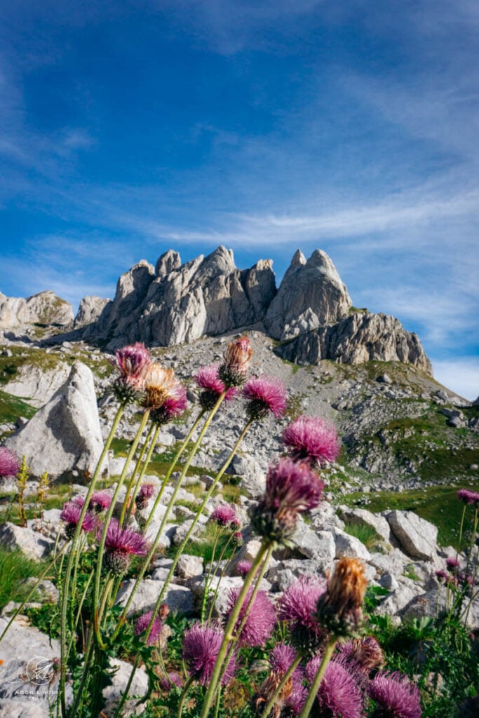
As we explored the park, some mountains reminded us of the Dolomites, while others of Iceland. The beauty of Durmitor is astounding and accessible.
From exhilarating peak hikes to deep forest walks, there’s something here for everyone. And, for those who love scenic drives, the mountain route between Žabljak and Piva Lake (P14 Žabljak – Trsa – Plužine) is not to be missed.
In this guide, we’re going to detail the best Durmitor National Park hiking trails plus fill you in on how to get to the park and where to stay.
- Entrance Fee: 5 EUR per person per day
- When to Visit: July, August, and September are the best months for hiking in Durmitor National Park. We hiked in the park in early September.
- Waymarking and Signage: Durmitor National Park hiking trails are marked with the Knafelc Waymark, which is a red circle with a white center. The Maps.me app was very reliable in this region. We were really impressed by the park’s signage and waymarking. It was a lot easier to follow trails here than in Prokletije National Park.
- Multi-Day Hikes: It’s possible to trek multi-day trails in Durmitor. Wild Camping (dispersed camping) is allowed within the park. We recommend using Cicerone’s Mountains of Montenegro guide for inspiration and route planning.
- Recommended Itinerary: Montenegro Itinerary: 2 Week Road Trip
- Get the Map: Durmitor & Prokletije Trekking Map (1:65,000)
- Where to Stay in Žabljak: Snam Rooms (budget), Vuk Popovic (midrange), Casa di Pino Eco Lodge Apartments (midrange-luxury), or Hotel Soa (luxury)
Durmitor National Park Map
Durmitor National Park Entrance Fee

There’s a 5 EUR entrance fee to visit the park. Please consult Nparkovi.me for updated pricing.
When we visited, it was possible to purchase discounted 3-day tickets as well.
Entrance tickets are collected at the Durmitor National Park entrance, located on the wide path to Lake Crno Jezero.
If you’re hiking into the park from other trailheads (e.g. Sedlo), there may, or may not be someone collecting the park entrance fee.
How to Get to Žabljak, Gateway to Durmitor National Park
Žabljak is the best base for exploring Durmitor National Park. It’s the gateway town to the park.
If you’re staying in the town center, you’ll be able to walk to the park entrance.
Car
From Kotor, it’s a 3-hour drive to Žabljak. From Podgorica, it’s a 2-hour drive.
We recommend using the Discovercars.com car rental reservation platform to search for and book car rentals in Montenegro. This easy-to-use booking platform compares car rental deals from 500+ trusted providers, so that you can choose the best option for your trip. Check car rental rates here.
With a car rental, you’ll be able to reach certain trailheads with more ease and drive along the stunning P14 scenic route that connects the towns of Žabljak and Plužine.
Public Transit
If you don’t have a car, don’t let that deter you from visiting this special corner of Montenegro. You can still reach Durmitor National Park with public transit, and when necessary, rely on local taxis to get you around.
The best way to get to Durmitor National Park without a car is by bus.
Podgorica to Durmitor National Park
There’s a bus line that connects Podgorica with Žabljak several times a day.
This bus takes about 2:30-3 hours. You can either opt for the direct line, or the indirect line, whereby you’ll change buses in Nikšić.
Podgorica Bus Terminal | Trg Golootočkih žrtava 1, 81000 Podgorica | Google Maps
Herceg Novi to Durmitor National Park
There is no direct bus line between Herceg Novi and Žabljak.
You’ll need to change buses in Nikšić. It looks like there are at least 3 daily departures from Herceg Novi to Nikšić each day.
Depending on the time of departure, it’ll take anywhere from 3:45 hours to 4:25 hours to reach Nikšić. And then, it’ll take an additional 1:40 hours to reach Žabljak.
Herceg Novi Bus Terminal | E65, Herceg Novi 85340, Montenegro | Google Maps
Use busticket4.me to find bus time tables and other routes to Žabljak.
Where to Stay in Durmitor National Park
Žabljak
The town of Žabljak is the perfect base for exploring the Durmitor mountains.
Though the town is small, it has everything you need to enjoy your alpine holiday. There are a number of restaurants, bakeries, and hotels to experience and stay in.
For those traveling to Durmitor without a car, look for accommodation in the “town center” (not on the P5 highway, Narodnih Heroja).
We suggest staying at least 3 nights in Žabljak, so you can get in 2 full days of hiking.
Budget | Apartments Sipcic or Snam Rooms
Midrange | Vuk Popovic is a very clean and spacious apartment fully furnished and stocked with necessary amenities. The apartment can sleep up to 4, or 5 people.
Top Choice – Midrange | We recommend staying in Casa di Pino Eco Lodge Apartments, a modern, tastefully-furnished accommodation with 8 rooms and apartments. The room rate includes a breakfast buffet and use of the Finnish sauna.
Luxury | Hotel Soa is the best accommodation if you want a spacious modern room, an excellent breakfast and spa facilities. The hotel is perfectly situated between the city center and the Crno Jezero (Black Lake).
Look for accommodation in Žabljak.
Durmitor National Park Hiking Trails
1. Bobotov Kuk

Bobotov Kuk (also spelled Bobotov Kuv), 2523 m, is the highest peak in Durmitor National Park.
There are a few ways to reach the peak, but the easiest and shortest way is from “Sedlo,” the pass on the scenic P14 road. It’s a 14km drive from Žabljak to the Sedlo trailhead.
If you have a car, you can drive directly to Sedlo, where you’ll find a small parking lot. Otherwise, you can hire a taxi.
Overall, the hike to Bobotov Kuv is moderately difficult. The first half is almost entirely flat, while the second half ascends through very rugged terrain.
The very last segment involves scrambling up some secured ropes.
You need to be surefooted and not afraid of heights to tackle the final stretch to the summit. We recommend hiking poles for this trail, to stabilize your descent.
If this sounds too challenging, still consider hiking the first half of the trail to the Lac Zeleni Vir lake.
After the hike, we recommend watching the sunset at Sedlo.
Trail Stats
Trailhead | Prevoj Sedlo
Distance | 9.9 km out-and-back
Time Needed | 5 hours
Elevation Gain/Loss | 939 meters
Difficulty | Moderately difficult
Minimum Elevation | 1899 meters
Maximum Elevation | 2523 meters
2. Planinica

Planinica (2330 m) is a high alpine plateau that boasts arguably the best view in the entire park. It takes 4:30 hours to reach Planinica, so this is a very long day hike.
The Planinica hike starts at Crno Jezero (Black Lake), which is very close to the park entrance. The beginning of the hike takes you along wide trails through thick forest in the direction of Zminje Jezero.
After passing through the Crepulj Pokhara meadow, you’ll soon emerge above the forest line.
The landscapes get increasingly more beautiful as you cut through high alpine meadows of Donja Alisnica (1931 m) and Gornja Alisnica (2064 m) dotted with grazing cows and horses.
After crossing the meadows, there’s a final climb to Planinica. Once you’re on the plateau, you can roam around for another 30 min for varying views.
Tip | The views from Planinica are best in the late afternoon. We lingered a bit too long on the plateau and struggled to make it back before sunset.
Trail Stats
Trailhead | Parkovisko I / Parking, Žabljak
Distance | 18.5 km out-and-back
Time Needed | 7:30 – 8 hours
Elevation Gain/Loss | 931 meters
Difficulty | Difficult
Minimum Elevation | 1427 meters
Maximum Elevation | 2330 meters
3. Mount Prutaš

Mount Prutaš (2393 m) is a striking mountain that’s reachable from the scenic P14 mountain road.
This would be a great hike to do if you’re heading to Plužine, since the Todorov Do trailhead is 24 km from Žabljak (45-min drive).
As you’re driving along R16, you’ll be able to see the mountain from the road. Mount Prutaš is the ultimate showstopper. It looks like a thick deli sandwich that’s resting on its side.
Unfortunately, we didn’t get a chance to hike to the summit, but it’s on our list for future visits.
Trailheads:
Option 1 Western Approach – Todorov Do (Pištet water spring). 1:30 hours one-way.
Option 2 Southern Approach (easier) – Dobri Do (Sarban water spring). 2:15 hours one-way.
Use SummitPost’s guide to plan your hike. There are other route options.
Trail Stats
Trailhead | Dobri Do (Sarban water spring) along P14
Distance | 8 km out-and-back
Time Needed | 4:15 hours
Elevation Gain/Loss | 699 meters
Minimum Elevation | 1700 meters
Maximum Elevation | 2393 meters
4. Skrka Lakes Valley

Veliko Škrčko jezero (Large Škrka Lake) and Malo Škrčko jezero (Small Škrka Lake) are two glacial lakes in Durmitor National Park situated in the Skrka Lakes Valley.
We saw these lakes from the summits of Bobotov Kuv and Planinica but didn’t get a chance to hike directly to the lakeshores.
There are few ways to hike to the lakes. You can opt for the western approach via Todorov Do (Pištet water spring), or the easier southern approach via Dobri Do (Sarban water spring).
Trail Stats
Trailhead | Dobri Do (Sarban water spring) along P14
Distance | 10.5 km out-and-back
Time Needed | 6-7 hours
Elevation Gain/Loss | 836 meters
Minimum Elevation | 1691 meters
Maximum Elevation | 2113 meters
5. Crno Jezero
Crno Jezero (Black Lake) is a glacial lake ringed by forest. It’s situated only 10 minutes from the Durmitor National Park Entrance, walking distance from Žabljak.
To reach the lake, you’ll walk along a flat, paved road. This lake marks the trailhead for many Durmitor hiking trails.
Trail Stats
Trailhead | Žabljak town center
Distance | 8.1 km lollipop-circuit
Time Needed | 2:30 hours
Elevation Gain/Loss | 72 meters
Difficulty | Easy
Minimum Elevation | 1427 meters
Maximum Elevation | 1475 meters
6. Via Dinarica Long Distance Trail

The Via Dinarica is a long-distance hiking route that traverses the Dinaric Alps through Slovenia, Croatia, Bosnia and Herzegovina, Montenegro, Kosovo, Serbia, Albania, and Macedonia.
The trail spans nearly 2,000 km and is broken up into 120 stages.
Stages 38 through 42 run through Montenegro, with the initial stages passing through Durmitor National Park.
Multi-day hikers could hike several stages of the Via Dinarica, by starting or ending in Žabljak.

More Montenegro Travel and Hiking Guides
Montenegro Travel
Montenegro HIking
Kotor:
- Things to Do in Kotor
- Where to Stay in Kotor
- Best Hikes in Kotor
- Pestingrad Peak Hike
- Vrmac Ridge Trail
- Kotor Fortress Hike
- Ladder of Kotor

Pin this Image for Future Trip Planning!
Stay Connected:
Connect with us on Pinterest.
Follow us on Instagram.
Like us on Facebook.
Support Us:
If you love reading our content, you can buy us a coffee via Ko-Fi.
