Refugio Jou de los Cabrones (2034 m) is the highest mountain hut in Picos de Europa National Park in Northern Spain. It’s also one of the most difficult huts to reach.
This recommended 2-day trek with an overnight in Refugio Jou de los Cabrones is a fantastic introduction to the high mountains of Picos de Europa.
Those that venture to Refugio Jou de los Cabrones will be rewarded with peaceful trails and pristine high-alpine scenery.
This route is challenging and should only be undertaken by experienced mountain hikers who have good trail intuition and stamina. There are some technical passages, which require sure-footedness and confidence in limestone terrain.
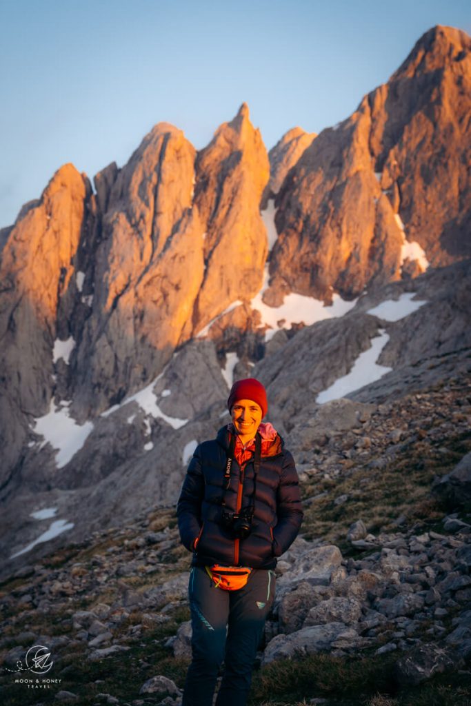
We hiked this route at the beginning of our Picos de Europa road trip. During the hike, I kept telling Kati, this is exactly why we love hiking: solitude, wildlife (chamois and vultures), challenging trails, and sensational scenery.
- Location: Picos de Europa Mountains Central Massif, Asturias
- Starting Point: Bulnes Funincular valley station in Poncebos | Google Maps
- Distance: 20.6 km circuit
- Days Needed: 2 Days
- Difficulty: Difficult
- Where to Stay: Refugio Jou de los Cabrones. Book online: reservarerefugios.com.
- Permits/Entrance Fee: None needed
Bulnes to Refugio Jou de los Cabrones Hiking Map
How to Book Refugio Jou de los Cabrones

First, it’s essential to make a reservation in advance. You can book your overnight stay in Refugio Jou de los Cabrones on reservarerefugios.com. When you book the hut online, you will have to make a deposit as part of the booking process.
Make sure to book half board (breakfast and dinner), if you want to eat in the hut. There’s no option to just show up and request dinner. They need to know in advance.
We paid 54 EUR when we made the booking (2 people + half board) and 24 EUR in person (cash only, reduced rate b/c alpine club membership).
Alpine Club Membership | Discount is administered to guests with Alpine Club ID cards on which the logo of the reciprocal rights agreement is printed. Learn more about alpine club membership in Tips for Hiking in the Alps.
Packing Essentials | Passport, Alpine Club Membership Card (if you have one), Cash, Sleeping Bag Liner like this Sea to Summit Silk-Cotton Blend Travel and Sleeping Bag Liner
Hut Contact Info | refugiojoudeloscabrones@gmail.com.
Where to Start the Refugio Jou de los Cabrones Trek
Poncebos, Asturias
This Picos de Europa 2-day hike begins in the village of Poncebos in Asturias.
You can either hike, or take the funicular up to the village of Bulnes. We opted for the funicular in order to trim off some elevation gain.
Bulnes Funicular

The Bulnes Funicular connects Poncebos with Bulnes, a mountain village in the Central Massif of Picos de Europa. Bulnes is only accessible by foot, or by this subterranean funicular; there is no vehicular access.
The 48-passenger Bulnes Funicular operates all-year-long. During operating times, the funicular departs at 30 minute intervals. It takes 7 minutes to ride the 2.23 km-long track up to Bulnes.
Low Season Operating Times | 10 am – 12:30 pm / 2 pm – 6 pm*
High Season Operating Times | 10 am – 8 pm*
*On weekdays (Mondays – Fridays), there’s also a single funicular ride at 8:30 am. This 8:30 am funicular is used to transport goods to Bulnes and it’s also used for waste management (garbage pick-up, etc…). Though it’s not widely advertised, it’s definitely possible to take this 8:30 am funicular (weekdays only) up to Bulnes. We did.
Tickets | 22.16 EUR roundtrip / 17.61 EUR one-way. We purchased a roundtrip ticket. You can use the return ticket the next day.
Stage 1: Bulnes to Refugio Jou de los Cabrones
- Starting Point: Bulnes Funicular valley station, Poncebos
- Trailhead: Bulnes Village
- Ending Point: Refugio Jou de Cabrones
- Distance: 7.4 km point-to-point
- Time Needed: 5 hours (6 hours with breaks)
- Elevation Gain: 1528 meters
- Elevation Loss: 108 meters
- Difficulty: Difficult
- Minimum Elevation: 623 meters
- Maximum Elevation: 2104 meters
The hike from Bulnes to Refugio Jou de los Cabrones is exciting as well as challenging. The trail isn’t frequented by day hikers, so it’s likely that you’ll pass very few people along this route. We didn’t pass anyone.
The stage begins with a gentle ascent from the lower Bulnes village to the upper Bulnes village. The trail continues to ascend to the Llanos del Tornu plain, grazed in summer, and then all the way up the steep, unrelenting Canal de Amuesa.
When you crest the sprawling Majadas de Amuesa pastures, the Refugio Jou de los Cabrones-bound path makes a sharp left. Ascend the La Cuesta del Trave slope ahead and then carefully follow the waymarks and cairns across the limestone landscape to Refugio Jou de los Cabrones.
Bulnes Funicular – Bulnes Lower Village – Bulnes Upper Village (25 minutes)

When you exit the funicular station, head left and follow the wide gravel trail to Bulnes (7 minutes).
Bulnes is divided into two neighborhoods: the lower village (Bulnes de Abajo / La Villa) and the upper village (Bulnes de Arriba / El Castillo).
You’ll first walk through the lower village, which is huddled around the Rio Tejo river. This is where the highest concentration of restaurants and guesthouses are located.
In the center of the village, cross the wooden bridge and bear right, following the sign to Refugio Jou de Los Cabrones (4:45 hours) / PR-PNPE-18 Joue de los Cabrones.
Follow the cemented path uphill. This countryside road (only used by the garbage collection tractor and farming tractors) brings you to the upper Bulnes village, which is labeled “El Castillo” on trail maps.
Walk by the El Caleyon bar and guesthouse and follow the cobbled path through the upper village. There’s a mountainside restaurant called Bar Mirador Lallende with an unbeatable view of Canal del Texu.
Continue hiking up the village, passing by a few more stone buildings. Soon, you’ll see an official Picos de Europa info board and another trail sign, indicating the direction of Amuesa and Refugio Jou de los Cabrones.
Bulnes Upper Village – Llanos del Tornu – Canal de Amuesa – Majadas de Amuesa (2:10 hours)

The path narrows and follows a dry stone wall through a shady verdant area and then emerges above the forest line.
Pass the noisy, spouting Fuente del Tornu fountain, which is on your right.
The trail steadily ascends to Llanos del Tornu, a plain and grazing area, studded with limestone boulders and flanked by soaring limestone walls.
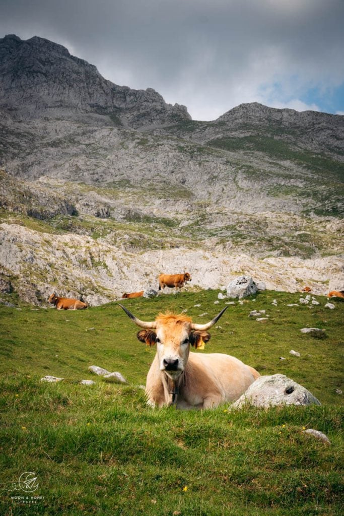
Along the way, we passed a dozen Asturian cows.
Keep your eyes out for vultures. We spotted three.
The path is marked with short timber posts bearing the familiar white and yellow striped waymark.
In clear conditions, the trail is obvious. Directly ahead, you can see the almost vertical Canal de Amuesa, which is where we’re headed. From a distance, it appears that the trail zigzags up the scree. But, in reality, it doesn’t. It favors the solid, vegetated grassy areas of the slope.
This alpine landscape reminded us so much of the Slovenian Alps. But, instead of dwarf pine, the ground is covered in ferns.

The trail climbs up the steep Canal de Amuesa slope. This is the most physically demanding part of the hike, especially on a sunny day.
With time, the Canal narrows and you’ll pass a water trough shortly before reaching a large boulder with blue writing. We took the left path and ascended to the sprawling plateau of Amuesa. This is also a summer mountain pasture teeming with cows. In the afternoon, most of them will be lying down.
We saw a young chamois gallop erratically through the herd, stunned by the sound of bells and all the animals, but the cows didn’t have any reaction.

When you crest the plateau, turn left in the opposite direction of Majadas de Amuesa (1415 m), a cluster of stone shelters used by herdsmen in the summer months.
Majadas de Amuesa – La Cuesta del Trave – Refugio Jou de los Cabrones (2:30 hours)

Cross the plateau in a southerly direction.
There is no sign indicating trail direction. Hopefully, they install one, because we were a bit confused here.
Head directly to the hill straight ahead and angle across it, aiming for 2:00. This slope is called La Cuesta del Trave.
The ascent continues, but thankfully, not as steep as before. After about 15 minutes (from the plateau), the trail splits. Take the right path. Soon, you’ll see a reassuring timber post.
There are some white-yellow-striped waymarks, painted on rocks, but they are very difficult to spot (at first). FOR THE LOVE OF ALL GODS AND GODDESSES, why do the Spanish mark their alpine trails in white and yellow??? You couldn’t pick worse colors.
Anyway, the trail continues up the grassy hill strewn with karst. The trail itself is smooth and easy on the feet.
Eventually, the path veers left and drops down into a depression, leaving the “La Cuesta del Trave” slope. There are cairns signaling the direction. Keep your eyes peeled.
We missed this left turn and went all the way to the base of the rocky karst hill (peak). We had to backtrack in order to find it.

To descend to the depression, you first have to cross a karst slope, which looks like a petrified choppy sea. It’s a bit tricky, but manageable.
From now on, the trail is much easier to follow. There are more freshly painted waymarks.
The path traverses a high-alpine, rocky gray landscape, maintaining a southerly direction.
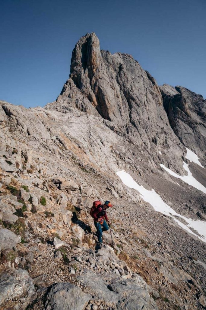
You’ll cut across rocky slopes and the occasional snowfield (early in the season). Some light scrambling may be needed.

Eventually, you’ll reach the base of a rope, which helps you ascend a vertiginous, exposed step.
This short secured passage brings you to the top of a crest (minor pass). The path immediately descends, then levels, and then ascends again.

For the next 30 minutes, the trail rises and falls across this barren, rocky landscape. Follow the waymarks.

There’s one more rope that aids you across a semi-exposed passage. Afterwards, you’re just minutes away from seeing the mountain hut.
Refugio Jou de los Cabrones is located in a depression, encircled by jagged peaks.

There are two paths that lead to the refuge. We chose the right path, across the scree.
Staying in Refugio Jou de los Cabrones

Refugio Jou de los Cabrones is a small managed refuge with a small dining area and a single dormitory room with capacity for 20 people.
As soon as we arrived, we were warmly welcomed. The check-in process was painless and uncomplicated. The manager just needed our passports.
There are blankets and pillows in the dormitory, but no sheets. You need to bring a sleeping bag liner.
We ordered dinner in advance when we made our reservation. If you want to eat dinner in the hut, that’s a necessity. Given the set-up, it’s not possible to casually order dinner on the day of arrival.
At 8 pm, the manager laid out a pitcher of water, a basket of bread, and a generous bowl of asparagus cream soup. Afterwards, he served a platter of tuna pasta, which was delicious. We were very satisfied with the meal.

Check-in | 7 pm latest
Dinner | 8 pm. Order in advance, when you make your overnight reservation.
Breakfast | 7 am – 9 pm. Let the manager know what time you’d like breakfast.
Electronics Charging Station | You can charge your phone in the dining area.
Drinking Water | There is a spring 30 meters below the hut.
Toilets | There’s an outhouse a stone’s throw away from the hut.
Sunset at Collado del Agua (30 minutes out-and-back)

Upon the recommendation of the manager, we hiked up to Collado del Agua after dinner.
Collado del Agua (2144 m) is a saddle above Refugio Jou de los Cabrones. It takes no more than 15 minutes to hike up here from the hut. This higher vantage point serves as a heavenly place to watch the sunset.
We stayed here a good hour watching the colors ripen to coral and pink.
Stage 2: Refugio Jou de los Cabrones – Horcada Arenera – Corona del Raso – Refugio Urriellu – Refugio de la Terenosa – Bulnes – Poncebos
- Starting Point: Refugio Jou de Cabrones
- Ending Point: Bulnes Village / Poncebos
- Distance: 13.2 km point-to-point
- Time Needed: 6 hours (8 + hours with breaks)
- Elevation Gain: 427 meters
- Elevation Loss: 1847 meters
- Difficulty: Difficult
- Minimum Elevation: 623 meters
- Maximum Elevation: 2274 meters
Stage 2 of this Picos de Europa trek begins with an undulating ascent up a quiet limestone rockscape to the Horcada Arenera saddle.
With far-reaching views, the trail continues across scree slopes to a ridge, which overlooks a massive basin and the pillar-shaped Naranjo de Bulnes peak, the most recognizable pinnacle in the Picos de Europa Mountains.
The path drops down a short, secured section (no special equipment needed) and then traverses a karst plateau to reach Refugio de Urriellu, situated at the base of Naranjo de Bulnes.
The hardest part is over. The hike descends along a very moderate and enjoyable path to Refugio de la Terenosa. From here, you’ll cross mountain pastures and then descend to Bulnes.
Refugio Jou de los Cabrones to Horcada Arenera (1:10 hours minimum)

The hike from Refugio Jou de los Cabrones to Refugio Urriellu is unforgettable. It’s high-alpine hiking, with some technical passages. There is a single secured section along the way.
No special equipment is needed. When we hiked this path on June 1st, we had to cross around 7 snowfields. We used microspikes for a few of the crossings (not absolutely necessary, but energy-saving and safer).
To locate the trail to Refugio Urriellu, head down to the spring. This is where we filled up our water bottles.
Follow the trail to the east. So, when you approach the spring and the hut is behind you, you want to go left (not straight).
The path is marked with green dots.
The trail ascends to a minor saddle (10 minutes). Hike over the saddle, following the green dots, fading blue dots, and cairns.

Maintain the same direction and pick your way across the stunning rock-word, crossing the occasional snowfield.
The trail brings you to the base of the 3-meter-high, yellow-green-white-striped pole. Enjoy the flat walking for as long as it lasts.
After a steep snowfield crossing, the trail climbs up to and enters a narrow valley-like depression.
For the next 30 minutes, the trail continues to ascend, over/through/above one sinkhole depression at a time.

The cairn-marked trail continues on a karst crest, a rise between depressions. At the end of it, you have to scramble up a rock step (put your hiking poles away for this).
The trail eases. You may pass a few more snowfields.
And, then the trail rises in zigzags up to the Horcada Arenera saddle (2273 m), the highest point along this 2-day hiking tour.

We took a 20 minute break here.
Horcada Arenera – Corona del Raso – Refugio Urriellu (1 hour minimum)

The path descends without difficulty, hugging the mountainside, above and around a depression.
After 10 minutes, the trail crosses a shoulder (spur).

The traverse ultimately brings you to Corona El Rasu (2180 m), where views open up to Naranjo de Bulnes, aka Picu Urriellu (2519 m), the most recognizable peak in Picos de Europa.

Refugio Urriellu is located at the western base of Naranjo de Bulnes.
This is really important. When you get to the ridge, head left (northeast) along it. Do not try to scramble down the wall immediately.

The trail follows the ridge to a gap and then drops down the Brecha de los Cazadores channel, which is secured with steel ladder rungs.

Face the wall and descend.
When you get to the base of the rung ladder, follow the chain to the right. The chain steers you safely to the correct trail. If you don’t follow the chain and continue to descend, the path quickly becomes unstable and precarious.
When the chain ends, the trail steeply twists down the brittle scree slope. Hiking poles are a godsend.

When the path eventually levels, keep hiking towards the flat face of Naranjo de Bulnes, crossing scree and karst pavement along the way. This stretch lasts longer than you’d think. It’s a bit exhausting, because you need to continuously focus on where you’re stepping.
Refugio Urriellu is another managed high-alpine hut and a popular day hiking destination. You can purchase drinks and snacks from the Cantina window. Bring cash.
We ordered a cheese plate.

Up until this point, we didn’t pass a single person. From here on out, you’ll start to see a lot more people on the trail.
Refugio de Urriellu – Collado Valleju – Refugio de la Terenosa (2:20 hours)

The most technical part of the hiking route is behind you. The way to Refugio de la Terenosa is obvious, well-maintained, and well-trafficked.
A few trails fan out from the hut in a northerly direction. Take the middle trail: PR21 Vega de Urriellu, marked with yellow-white waymarks. The left trail, PR19 Canal de Camburero, is also an option, but far more difficult.
The well-graded PR21 trail smoothly descends in serpentines, braiding into parallel paths at times. After 40 minutes, the Terenosa-bound path weaves through a boulder rockscape.

The path develops into a spectacular balcony trail. This spellbinding stretch of trail makes you feel lucky to be alive and grateful to be able-bodied to experience it.
We walked as slowly as possible, trying to stretch out every second on the trail.

The balcony path ultimately leads to the rocky Collado Valleju (1542 m), which serves as a gateway to a gorgeous mountain slope, brimming with colorful wildflowers.
With views of the Pandébano pasture ahead, traverse the colorful slope on an earthly, comfortable trail all the way down to Refugio de la Terenosa (1300 m).
We took a 15 minute break here, enjoying the sun and a complimentary symphony composed of birdsong and cowbells.
Refugio de la Terenosa – Collado de Pandébano – Bulnes (1:45 hours)

After the last stone hut of the Terenosa mountain pasture, turn left.
The loamy trail crosses the Vega les Cuerres mountain pasture, animated with grazing Asturian cows.
At the wide saddle of Collado de Pandébano, you can see Sotres, the highest village in Picos de Europa. Turn left and follow the red-white trail markers to Majada Entremosquines (1185 m).

The way to Bulnes seems to drag on forever. It dips in and out of the forest, mostly following a stream.
It’s very muddy. The trail is stabilized by rocks, so that the path doesn’t turn into a mudslide. With fresh legs, maybe this trail isn’t so bad. But, with our tired legs, it was exhausting. I wrote “nightmare” in my notes…so it must have felt that way.
Along the way, there are some unmarked junctions. We followed the red-white plastic streamers that were tied to various tree branches.

Ultimately, the path drops down to Bulnes. The final stretch is pleasant enough, but hardly makes up for that ghastly trail before.
Bulnes to Poncebos (15 min – 1:30 hours)
By the time we arrived in Bulnes, all the restaurants were no longer serving food. After a drink we walked back to the funicular mountain station and rode it down to Poncebos.
We used the roundtrip ticket we purchased the day before and it was not a problem.
Where to Go Next in Picos de Europa National Park
If you haven’t already hiked the Ruta del Cares trail, we recommend staying the next two nights in Poncebos in order to tackle that unforgettable day hike.
Where we stayed – Budget | Arcea Hotel Mirador de Cabrales is a hotel and restaurant that offers clean rooms with private bathrooms. Breakfast is included and consists of bread, tomato olive oil spread, jams, croissants, orange juice, and coffee. It’s simple, but the location is unbeatable. You can park in the hotel car park, or along the road, across the hotel.
Budget | Hostal Poncebos is the unmissable orange building, located at the entrance of Poncebos, along the Cares River. This accommodation offers rooms with private and shared bathroom facilities. Breakfast is included. They also have a restaurant and free on-site parking.
Budget | Hotel Garganta del Cares offers simple private rooms and on-site parking in Poncebos. This is the closest hotel to the Ruta del Cares trailhead. Breakfast is an additional charge.
Look for accommodation in Poncebos.
After the trek, we continued our trip to Potes in Cantabria.

Picos de Europa Trip Planning Essentials
Picos de Europa National Park stretches across three regions in Northern Spain: Asturias, Cantabria, and León (Castile and León).
It comprises the majestic Picos de Europa Mountains, a limestone mountain range composed of three massifs.
How to Get to Picos de Europa
The closest airports to Picos de Europa are Santander Airport in Cantabria, the Asturias Airport (aka Oviedo-Ranón, OVD) in Asturias, and the Bilbao Airport in Basque Country.
We recommend renting a car from the airport and driving directly to Picos de Europa National Park. Follow our 10-day Picos de Europa road trip itinerary for inspiration.
Use the intuitive Discovercars.com car rental reservation platform to search for and book car rentals. This easy-to-use booking platform compares car rental deals from 500+ trusted providers, so that you can choose the best option for your trip.
Where to Stay in Picos de Europa
We recommend dividing your time between Northern Picos de Europa and Eastern Picos de Europa. If you have more time, extend your visit to Southern Picos de Europa and Northwestern Picos de Europa.
Northern Picos de Europa: Poncebos, Arenas de Cabrales (Las Arenas), Sotres, or Tielve in Asturias
Eastern Picos de Europa: Potes, or Camaleño Valley in Cantabria
Southern Picos de Europa: Valdeón Valley, or Caín in León
Northwestern Picos de Europa: Cangas de Onís, Soto de Cangas, Llerices, or Covadonga in Asturias
Find out where to base yourself in the national park in Where to Stay in Picos de Europa.
Hiking in the Picos de Europa National Park
Hiking in Picos de Europa National Park is an extraordinary experience filled with magical landscapes of lush forests, craggy mountains, and deep gorges.
During our road trip, we hiked the Ruta del Cares trail, the El Cable to Fuente Dé trail, Brez to Canal de las Arredondas circuit trail, and the Covadonga Lakes to Vega de Ario trail.
Picos de Europa Packing List
Hiking Gear
- Day Pack: Osprey Tempest 30 Women’s Backpack / Osprey Talon 33 Men’s Backpack
- Grade B/C high-cut hiking boots: Meindl Schuhe Island Lady (Kati’s Boots), Women’s Hanwag Tatra II GTX (Sabrina’s Boots), Men’s Hanwag Tatra II GTX (men’s equivalent)
- CAT 4 Sunglasses: Julbo Shield Mountain Sunglasses
- Hiking Poles: Black Diamond Trail Trekking Poles
- Reusable Water Bottle: Ion Leakproof 32 oz Water Bottle
Outdoor Photography Gear
- Camera Body: Sony Alpha a6400
- Mid-range Zoom Lens: Tamron 17-70mm 2.8 Di III-A VC RXD
- Wide angle Zoom Lens: Sony – E 10-18mm F4 OSS Wide-angle Zoom Lens
- Backpack Camera Clip: Peak Design Camera Clip
Pin this Image for Future Trip Planning!
Stay Connected:
Connect with us on Pinterest.
Follow us on Instagram.
Like us on Facebook.
Support Us:
If you love reading our content, you can buy us a coffee via Ko-Fi.

Hi Sabrina: Awesome post. We are considering doing the hike as you described it but on the 2nd day we get to and stop overnight at Refugio de la Terenosa. Then after descending down to Bulnes we keep walking to Sotres to Tielve and then pick bus to Poncebos, thus doing both this hike and the walk around the villages of poncebos/bulnes/sotres/tielve/poncebos. However regarding the 1st 2 days had a couple questions. We’ve hiked a fair bit thru the Stubai alps, dolomites etc. We are not technical climbers just solid trampers. (a) In the hike up to Refugio Jou de los Cabrones there is a section where we use a rope to get up the slope. Do we have to depend on the rope to find our way up or is it more like we are climbing up but using the rope for protection and to provide addl support? Asking cos neither my husband nor I could kinda climb up a rope you know? But like a low grade Via Ferrata we could climb up rocks while holding onto a rope. Can you advise? (b) Once you get the rope section, the picture you showed of the other side looked pretty steep. Again is this just the angle of the photo and we can kinda find footings in the crevices and pretty much find our way down? It would be sad to overstate our skill level and get to that point and then be unable to go further. (c) In checking out the hiking path at various points it almost seems like a social path. We will have Gaia GPS, but where would we find a paper map, and what else did you use to ensure you were on the right track? Or am I mis-stating and its fairly well sign-posted? (d) We are planning to do this hike (if we can) in late September 2023. Any ideas when the snow fall comes thru in these areas? Thanks for all your advice, and would much appreciate your insight on these points. Best Regards, Chitra
Hi Chitra,
There are two short sections with a fixed rope on stage 1.
The rope is simply an aid that will help you up, or across an exposed area. You don’t need to be a climber, or have any climbing equipment. Kati and I are not climbers. There are some steep areas, which any experienced hiker can tackle with care and caution.
The trail is marked with painted waymarks, but some are fading (stage 1). We had some trouble locating a turn after Majadas de Amuesa, because of the fog. Yes, I would definitely download offline Maps like GAIA for orientation.
We purchased a paper trail map in a shop in Las Arenas, before driving to Poncebos.
I don’t know what conditions are typically like in late September. I would reach out directly to the hut manager and ask.
Have a great trip to Picos de Europa!!!
Sabrina
Sorry but to add to the note above. Are we better off doing the hike the other way then so we can rappel down the wall section? Or are there rope sections the other way as well so really we are in the same fix? Thanks so much, Chitra
Hi Sabrina: Quick follow up. What do you think about walking from Terenosa straight to Sotres instead of going back to Bulnes? We wondered if we could do that and then continue on the village to village walk next day. Any thoughts much appreciated! Thx Chtira
Hi Chitra,
I think that’s definitely doable/feasible. And, by doing so, you’d cut off the taxing final stretch to Bulnes.
-Sabrina
Hi Sabrina,
Love the look of this hike and keen to do it, thanks for sharing the detailed information.
Had a look at booking the Refugio, and unfortunately jou de los cabrones is booked out for when we will be there. I wanted to get your thoughts on doing this hike in reverse and staying at Vega de Uriellu instead. Wasn’t sure on the inclines/declines, marked trails etc. if one was to go the other way round.
Are you able to share the trail/path names to help with further research that you did?
Thanks,
Eddie
Hi Eddie,
It’s possible to reverse the route, however it would be far more difficult.
Day 1: Bulnes – Refugio Terenosa – Refugio Urriellu
Distance: 7.9 km
Time Needed: 5 hours minimum
Elevation Gain: 1410 meters
Elevation loss: 99 meters
Day 2: Refugio Urriellu – Refugio Jou de los Cabrones – Bulnes
Distance: 11.2 km
Time Needed: 6 hours minimum
Elevation Gain: 542 meters
Elevation Loss: 1876 meters
Trail numbers aren’t very clear. Try to secure the Picos de Europa Macizos Central y Oriental 1:25.000 trail map by Adrados Ediciones.
All the best,
Sabrina