The best way to experience New Zealand is with your own two feet. New Zealand is a hiker’s paradise. During our three months traveling in NZ, we sought out the best trails and hiked as much as possible.
We’ve assembled our favorite hiking trails below for both the North and South Islands. You’ll find a range of short and long day hikes as well as 2-day hikes.
We’ve also included trails we didn’t experience due to poor weather, or lack of proper equipment (basically our wishlist for our next trip).
So, if you’re asking “where should I hike in New Zealand,” or “what are the best backcountry hut hikes,” keep reading because we’ve got you covered.
- When to Hike in New Zealand: December – March
- South Island Itinerary: 4 Week South Island Itinerary
- North Island Itinerary: 3 Week North Island Itinerary
- Hiking Guidebooks: Day Walks in New Zealand: 100 Great Tracks by by Shaun Barnett & Geographx, Lonely Planet Hiking & Tramping in New Zealand, and Lonely Planet Best Day Hikes New Zealand
- Travel Guidebooks: Lonely Planet New Zealand
- NZ Hiking Trails and Huts Info: Use the DOC (Department of Conservation) website to learn about DOC trails, huts, camping grounds, and national parks.
- Weather forecast: Consult MetService
- Rental Car: We recommend using the Discovercars.com car rental platform to search for and book car rentals.
New Zealand Hiking Map
NZ Hiking Destinations
Tongariro National Park
Egmont National Park
Hawke’s Bay
Putangirua Pinnacles
Nelson Lakes National Park
Arthur’s Pass National Park
Mount Cook National Park
Wanaka
Mount Aspiring National Park
Queenstown
Fiordland National Park
Best Hikes in Tongariro National Park, North Island

1. Tongariro Alpine Crossing
New Zealand’s greatest day hike really lives up to its name. This outstanding hike weaves through rugged volcanic terrain and rewards you with unforgettable views of Mount Ngauruhoe (“Mount Doom”), emerald pools, craters, and lakes.
This is a point-to-point hike, so you need to organize a shuttle transfer a few days in advance. It’s no longer possible to park your car at Mangatepopo Road for the day (4-hour limitation).
And, unless you start hiking at 6 am, you won’t secure a parking place at Ketetahi.
Learn more: Tongariro Alpine Crossing DOC Booking System
Trailhead | Mangatepopo, or Ketetahi. It’s more popular to hike from Mangatepopo to Ketetahi. | Google Maps (Mangatepopo), Google Maps (Ketetahi)
Distance | 19.7 km point-to-point
Time Needed | 7:30 hours
Elevation Gain | 796 m
Elevation Loss | 1161 m
Difficulty | Moderately Difficult
Minimum Elevation | 759 m
Maximum Elevation | 1848 m
Guided tours | Premium Tongariro Crossing Guided Group Walk or Private Tongariro Crossing Guided Walk
2. Mount Ruapehu’s Crater Lake
Mt. Ruapehu is an active volcano in Tongariro National Park.
In summer, this ski region turns into a quiet hiking destination. There are a few marked trails on the mountain (Skyline Ridge, Waterfalls Descent, Meads Wall), but the most exciting option, Mt. Ruapehu crater lake, is unmarked.
To reach the crater lake near the summit, you can join a guided trek or hike there independently (weather and visibility permitting). You can begin the hike from the base of the Iwikau Ski Village and hike the Waterfalls Trail up to Knoll Ridge, or you can take the Sky Waka Gondola up to Knoll Ridge.
Trailhead | Iwikau Village, Whakapapa Ski Area | Google Maps
Distance | 10.8 km out-and-back (from the village), 6.1 km out-and-back (gondola option)
Time Needed | 7 hours ( from the village), 5 hours (gondola option)
Elevation Gain/Loss | 1033 m (from the village) / 643 m (gondola option)
Difficulty | Challenging
Minimum Elevation | 1613 m
Maximum Elevation | 2672 m
Guided tours | Premium Mt Ruapehu Summit Plateau Guided Group Hike or Private Mt Ruapehu Summit Plateau Guided HIke
3. Taranaki Falls
If you’re looking for a short hike and love waterfalls, don’t miss out on this trail. This circuit trail takes you to the striking Taranaki Falls, which tumble over the edge of a large lava flow into a rocky pool.
We saw lots of waterfalls in New Zealand and this was one of our absolute favorites.
Trailhead | Whakapapa Village | Google Maps
Distance | 6.8 km circuit
Time Needed | 2 hours
Elevation Gain/Loss | 127 m
Difficulty | Easy
Minimum Elevation | 1099 m
Maximum Elevation | 1220 m
4. Tama Lakes
The Tama Lakes Trail follows the Taranaki Falls trail. After passing the waterfall, you’ll continue through tussock country to the Lower Tama Lake lookout.
The steepest part of the hike is to the Upper Tama Lake viewpoint. We hiked to the lakes on a cold, low visibility day, so we didn’t see views of Mount Ngauruhoe and Mount Ruapehu. We recommend doing this tramp on a clear day.
Trailhead | Whakapapa Village | Google Maps
Distance | 18 km out-and-back
Time Needed | 5:30 hours
Elevation Gain/Loss | 459 m
Difficulty | Moderately Difficult
Minimum Elevation | 1128 m
Maximum Elevation | 1437 m
Where to Stay in Tongariro National Park for Hiking
Camping | Kaimanawa Road Campsite is a free campground for SC and NSC vehicles. Given its proximity to Ketetahi Car Park (where the Tongariro Alpine Crossing hike ends), this campsite fills up early.
Budget | Pipers Lodge is a great value accommodation, located in Tongariro National Park. The lodge features a bar and restaurant, a lounge with an open fireplace, and a communal kitchen. Guests also have access to hot tubs and a game room (ping pong, pool, etc…).
Midrange | Chateau Tongariro Hotel is a stately hotel in Whakapapa Village set in the heart of Tongariro National Park, at the base of Mount Ruapehu. You can hike to Tama Lakes and Taranaki Falls directly from the hotel. During your stay, you can enjoy the indoor pool, fitness center, sauna, game room, and hotel cinema. Tip: make a reservation for high tea, which is a bucket list experience for many.
Luxury | Tongariro Suites in Ohakune delivers a polished and elevated experience with its attention to detail, modern furnishings, and spacious rooms. A free breakfast basket is delivered to your room, so you can enjoy breakfast in bed.
Look for accommodation in Tongariro National Park.
Best Hikes in Egmont National Park, North Island

5. Mangorei Track to Pouakai Range
This hike promises some of the best views of Mount Taranaki. For the first two hours, you’ll hike through Egmont’s Goblin Forest via a slow ascending staircase track.
The forest is dense and the trees are festooned with heavy moss. It’s both enchanting and eerie.
Once you get above the bushline, you’ll enter a dwarf shrubland area where the views begin to expand.
The day we hiked this trail, Taranaki and the whole region were shrouded in impenetrable fog. The fog didn’t lift for us, so we can’t say how good the views are.
The destination of this hike are the Pouakai Tarns (20 minutes from the Pouakai hut), which reflect the volcano on a clear day.
Trailhead | Mangorei Road Car Park, New Plymouth | Google Maps
Distance | 12.3 km out-and-back
Time Needed | 5 hours
Elevation Gain/Loss | 788 m
Difficulty | Moderate
Minimum Elevation | 515 m
Maximum Elevation | 1225 m
6. Wilkies Pool and Dawson Falls Circuit
This easy hike takes you into Egmont’s Goblin Forest to various cascading waterfalls and pools.
Because of heavy rainfall in this region, the trees are draped in heavy moss.
We hiked to the Dawson falls via the Wilkies Pool and Ridge Loop Tracks. If you don’t have a few hours, you can also park at the Visitor Center, walk down the road you drove up (5-10 min), and follow the signs to the falls.
Trailhead | Dawson Falls Visitors Centre | Google Maps
Distance | 4 km circuit
Time Needed | 1:30 – 2 hours
Elevation Gain/Loss | 189 m
Difficulty | Easy
Minimum Elevation | 848 m
Maximum Elevation | 1037 m
More Hikes in Egmont National Park
Fanthams Peak (Day Hike): We wanted to do this hike, but opted out, because of poor visibility. Total Time: 5 – 6 hours. Trailhead: Road end at Dawson Falls. Learn more: DOC Fanthams Peak
Pouakai Circuit (Multi-Day Trek). This is an interesting 2-3 day circuit trek. Learn more: DOC Pouakai Circuit
Where to Stay in Egmont National Park for Hiking
Camping | Volcanoview is a popular tavern and campground offering paid spaces for SC and NSC vehicles as well as tents.
Midrange | Dawson Falls Mountain Lodge is situated at an elevation of 905 meters above sea level on the south-eastern slopes of Mount Taranaki within Egmont National Park. With its unbeatable location and volcano views, you’ll love your stay here. The hotel dates back to 1896 and features 12 guest rooms, all furnished in a warm, alpine style. Guests love the onsite restaurant (fully licensed). From the lodge, you can hike directly to Wilkies Pools, Dawson Falls, and Fanthams Peak.
Midrange | Ngati Ruanui Stratford Mountain House is a top-rated accommodation in Egmont National Park, surrounded by forest and native gardens. After exploring the Goblin Forest, guests can savor the sauna and steam room and dine at the on-site Mountain Café and Mountain Restaurant (open Wednesdays – Sundays).
Look for accommodation in Egmont National Park.
Best Hikes in Hawke’s Bay, North Island

7. Cape Kidnappers Gannet Reserve
Bird sanctuaries and wildlife parks are enjoyable, but if you have an opportunity to witness birds in their natural habitat, it’s far more rewarding.
Cape Kidnappers is home to four gannet colonies, where an estimated total of 15,700 gannets live. It’s a 2-hour beach walk to reach the Black Reef Colony and an additional 45 min to reach the Plateau Colony.
It gets really windy along the coast, so make sure you have a proper rain/wind jacket.
The best time of year to hike this trail is in early November to late February, when the chicks have hatched. In March, the gannets start their migration to Australia.
The best time of day to visit is low tide. Lonely Planet recommends: “leave no earlier than 3 hours after high tide; start back no later than 1.5 hours after low tide.” Use MetService to check the tide, as it varies each day.
Trailhead | Car Park in Clifton | Google Maps
Distance | 19.4 km out-and-back
Time Needed | 5 hours
Difficulty | Moderate
Elevation Gain/Loss | 200 m
Minimum Elevation | 0
Maximum Elevation | 110 m
Guided tours | Find out about alternative ways to experience the gannet colonies at Cape Kidnappers.
Where to Stay in Hawke’s Bay for Hiking
Camping | Foreshore Reserve Freedom Camping (for NO-SC ONLY)
Budget | Birds Eyes Te Awanga is a bed and breakfast in Te Awanga, close to the Clifton trailhead. Guests have access to a garden as well as a shared lounge and kitchen. Travelers love the peaceful location (close to the sea), the breakfast, and Ros (the host).
Midrange | Te Awanga Cottages (2 nights minimum) is a bright and cheerful place to stay in Te Awanga, ideal for hikers seeking a private and relaxing accommodation. Each unit has a fireplace, a living room, a fully equipped kitchen, and a washing machine.
Luxury | The Farm at Cape Kidnappers is a five-star, one-of-a-kind accommodation in Cape Kidnappers, perfect for special occasions, honeymoons, and romantic getaways. All meals are included (breakfast, lunch, and dinner). At this upscale farm, you’ll savor vast ocean views, an open fireplace, the wine cellar, tasting room, and a swimming pool and hot tub.
Look for accommodation near Cape Kidnappers.
Best Hikes in Aorangi Forest Park, Wairarapa, North Island
8. Pinnacles Track, Putangirua Pinnacles Scenic Reserve
Take the loop track up to the base of the pinnacles (up the river bed) and then to the lookout point.
The pillars consist of partially cemented greywacke gravels that have been contoured by water and wind. When you’re at the base, the pinnacles tower above you.
This is also a Return of the King, Lord of the Rings filming location.
This badlands-like landscape is a unique landform in New Zealand. After exploring the Pinnacles, check out the seal colony on the way to Cape Palliser Lighthouse.
Trailhead | Putangirua Pinnacles Scenic Reserve (one hour from Martinborough). You can also camp here. | Google Maps
Distance | 3.7 km lollipop-circuit
Time Needed | 2 hours
Elevation Gain/Loss | 199 m
Difficulty | Easy
Minimum Elevation | 22 m
Maximum Elevation | 221 m
Where to Stay near Putangirua Pinnacles Scenic Reserve for Hiking
Camping | The Putangirua Pinnacles Campground is located at the Pinnacles walk trailhead. Camping fees are very reasonable.
Budget | Waimeha Camping Village is a dream accommodation on the coast for those on a budget. They offer cabin-like container units as well as powered and non-powered sites for campers. Enjoy the sunset. Guests have access to a communal bathroom, kitchen, BBQ facilities, and activity room.
Luxury | Wharekauhau Country Estate is a luxurious, ocean-facing cottage with an outdoor pool, tennis court, and double spa bath. Breakfast and a 4-course gourmet dinner are included.
Look for accommodation near Putangirua Pinnacles.
Best Hikes in Nelson Lakes National Park, South Island

9. St. Arnaud Range Track
Nelson Lakes National Park is one of our favorite hiking destinations in New Zealand. There’s very light traffic on the trails and the views are simply phenomenal.
The St. Arnaud Range Track starts at Kerr Bay and climbs to the summit of the St. Arnaud Mountain Range.
For the first two hours, you’ll ascend steadily through thick beech forest to the sound of humming bees.
Once you get above the bushline, you’ll see magical views of Lake Rotoiti and Mount Robert. The final push to the summit is very steep, but keep pushing.
When you get to the top, you can hike the ridge and see beautiful tarns (mountain lakes) on the other side as well as countless mountains stretching out in every direction.
Trailhead | Eastern corner of Kerr Bay, on the edge of Lake Rotoiti in St Arnaud | Google Maps
Distance | 10.9 km out-and-back
Time Needed | 5:30 hours
Elevation Gain/Loss | 1072 m
Difficulty | Difficult
Minimum Elevation | 624 m
Maximum Elevation | 1696 m
10. Robert Ridge Trail to Angelus Hut 2-Day Hike
It’s hard to pick a favorite hike in NZ, but this might be it. The initial zig zag Pinchgut Track is a pain-in-the-ass, but it gets you above the bushline really quickly.
The majority of the hike follows Robert Ridge along a pole-marked route. The views crescendo in beauty. The final destination is Angelus Hut, situated at Lake Angelus. It’s paradise! You first see the lake from the mountain ridge above. The last stretch is a rocky descent to the hut.
Only hike this trail during fair conditions.
Trailhead | Mt. Robert Carpark | Google Maps
Distance | 23.1 km out-and-back
Time Needed | 9-10 hours (2 days total)
Elevation Gain/Loss | 1188 m
Difficulty | Difficult
Minimum Elevation | 884 m
Maximum Elevation | 1779 m
More Hikes in Nelson Lakes National Park
Lake Angelus to Hopeless Hut, Sunset Saddle (Multi-Day Trek). You could lengthen the Angelus Hut hike (see above), by hiking to Hopeless Hut the next day. It’s an unmarked route, but the ward at Lake Angelus was recommending it to other hikers.
We didn’t have enough supplies to continue hiking for another two days, but this is something we’d love to do if we come back. Note: the route requires traversing over scree. You need to be experienced and very fit to attempt this.
Travers-Sabine Circuit (Multi-Day Trek) – This is a 4-7 day tramp. Total Distance: 80 km. DOC Trail Page.
Where to Stay in Nelson Lakes National Park for Hiking
Camping | Teetotal Campsite is a large campsite, suitable for NSC and SC vehicles. There’s only one dry toilet on site. For showers, head to West Bay Campsite on Lake Rotoiti. You can buy a shower token from the DOC Visitor Center.
Midrange | Avarest Bed & Breakfast is a welcoming B&B in Nelson Lakes National Park, a mere 2-minute walk from Lake Rotoiti. Guests have free use of the BBQ facilities, shared lounge area, terrace, and laundry room.
Luxury | The Woodsman’s Den is a 2-bedroom private guesthouse in Saint Arnaud. During your stay, you can wander around the 10-acre property, collect your own organic free-range eggs and seasonal vegetables, dip in the hot tub, and rest by the fireplace.
Look for accommodation in Nelson Lakes National Park.
Best Hikes in Aoraki Mount Cook National Park, South Island

11. Sealy Tarns Track
This staircase track to heaven takes you to a small mountain tarn. The views of Hooker Valley and Mount Cook are so impressive that you won’t even care that it took 2,200 steps to get there.
Sealy Tarns also makes for a great picnic spot. If you continue up the same track, you’ll reach Mueller Hut in 2 hours.
Trailhead | White Horse Hill car park, at the end of the Hooker Valley Road | Google Maps
Distance | 5.3 km out-and-back
Time Needed | 3 hours
Elevation Gain/Loss | 560 m
Difficulty | Moderately Difficult
Minimum Elevation | 769 m
Maximum Elevation | 1312 m
12. Mueller Hut 2-Day Hike
The red Mueller Hut is the most iconic mountain hut in New Zealand. You can hike up here and back in a day, but it would be a great shame if you didn’t sleep here. Just make sure you book the hut well in advance. The first half of the track is to Sealy Tarns via a staircase switchback trail.
The second half of the track is unformed. You’ll follow orange poles over the ridge and to the hut. The second half is more challenging, due to scree and rocky terrain. Take your time and go slowly. This will likely be one of your most memorable experiences in NZ.
Trailhead | White Horse Hill car park, at the end of the Hooker Valley Road | Google Maps
Distance | 9.1 km out-and-back
Time Needed | 2 Days, or 6 hours total
Elevation Gain/Loss | 1043 m
Difficulty | Difficult
Minimum Elevation | 769 m
Maximum Elevation | 1800 m
13. Hooker Valley
This easy and flat track leads you through Hooker Valley over several swing bridges. The track ends at Hooker Lake. It’s a very popular hiking trail in Aoraki Mount Cook National Park, so start this hike early to avoid the crowds.
Trailhead | White Horse Hill car park, at the end of the Hooker Valley Road | Google Maps
Distance | 10.2 km out-and-back
Time Needed | 3 hours
Elevation Gain/Loss | 146 m
Difficulty | Easy
Minimum Elevation | 757 m
Maximum Elevation | 888 m
More Hikes in Aoraki Mount Cook National Park
Blue Lakes and Tasman Glacier View (40 minute walk) and Tasman Glacier View (1 hour walk) – views of the Tasman Glacier Terminal Lake. Trailhead: Car Park at the end of the Tasman Valley Road. Learn more: DOC Trail Page.
If you are interested in guided hikes in Aoraki Mount Cook National Park, check out these activities.
Where to Stay in Aoraki Mount Cook National Park
Camping | White Horse Hill Campground is located directly at the Hooker Valley trailhead. This campground is suitable for both NSC and SC vehicles.
Budget | Haka House Aoraki Mt Cook is an affordable youth hostel in Mount Cook National Park, offering both private and dormitory rooms.
Midrange | Aoraki Mount Cook Alpine Lodge is a comfortable and friendly accommodation in Mount Cook Village. Guests loved the mountain views, location, and the shared kitchen.
Midrange | Aoraki Court Motel is a modern, apartment-style accommodation in Mount Cook Village, ideal for couples and families. Each unit has a kitchenette.
Look for accommodation in Aoraki Mount Cook National Park.
Best Hikes in Wanaka, South Island

14. Roys Peak
This is a calf burner. This steep track steadily winds through farmland up to the summit of Mount Roy. The views are spectacular from every vantage point.
The track itself is more like a road, so you’ll have no problem knowing where to go.
Trailhead | Roys Peak Track car park on the Mount Aspiring Road | Google Maps
Distance | 15.8 km out-and-back
Time Needed | 7 hours
Elevation Gain/Loss | 1240 m
Difficulty | Moderately Difficult
Minimum Elevation | 333 m
Maximum Elevation | 1572 m
15. Isthmus Peak
Far less popular than Roys Peak (for no good reason), the Isthmus Peak traverses farmland with views of Lake Hāwea.
When you get up on the ridge, you’ll have 360 degree views of both Hawea and Lake Wanaka.
We hiked here in late March to the sound of rutting stags and the smell of mountain goats. The trail is soft (mostly grass) and ascends gently.
Trailhead | Stewart Creek car park is off SH6 | Google Maps
Distance | 15.8 km out-and-back
Time Needed | 7 hours
Elevation Gain/Loss | 1015 m
Difficulty | Moderate
Minimum Elevation | 371 m
Maximum Elevation | 1385 m
Where to Stay in Wanaka for Hiking
Budget | YHA Wanaka is a clean and comfortable backpackers’ hostel set in a great location, close to the lake. Guests love the staff, the well-stocked kitchen, communal lounge and dining area, and the rooms. Double rooms available.
Luxury | Edgewater is situated on the shores of Lake Wanaka. The hotel’s restaurant and café are open daily for breakfast, lunch, and dinner. In addition to their seasonal menus, they bake 6 different scones daily and offer Sunday Roast and High Tea, by arrangement. The hotel facilities include a spa, two all-weather tennis courts, a 9 hole putting green, a children’s playground, and a Pétanque.
Look for accommodation in Wanaka.
Best Hikes in Queenstown, South Island

16. Ben Lomond Track
This is a must-do hike in Queenstown. The first section of the Ben Lomond hike weaves through forest. Once you get above the forest line, you’ll hike through tussock grasslands and see Lake Wakatipu.
Once you reach the Ben Lomond Saddle, you’ll see layers and layers of peaks. The hardest part of the trail is between the Ben Lomond Saddle and the Summit.
If you’re lucky, a Kea might drop by to say hello.
Trailhead | Option #1: Valley or Mountain Station of the Skyline Gondola. If you hike from the bottom, take the “Tiki Trail” and follow signs for Ben Lomond Saddle (Ben Lemond Track). | Google Maps; Option #2: One Mile Creek Track to Ben Lomond Saddle. The One Mile Creek Track follows an old pipeline. We opted for this track, because we had already hiked the Tiki Trail.
Distance | 10.9 km out-and-back (via Ben Lomond Track from Skyline Gondola Mountain station)
Time Needed | 6 hours
Elevation Gain/Loss | 1043 m
Difficulty | Moderately difficult
Minimum Elevation | 792 m
Maximum Elevation | 1728 m
17. Tiki Trail to Skyline Complex
This steep hike zig zags through pine forest. The end destination is the Skyline Gondola Complex, where there’s a fantastic view of Queenstown.
You can also grab a beverage, or a bite to eat at the cafe. The trail itself is unremarkable, but the view is great! If you’re short on time, you should take the Gondola up and hike to the Ben Lomond Saddle instead.
Trailhead | Skyline Gondola valley station | Google Maps
Distance | 4 km out-and-back
Time Needed | 2:30 hours
Elevation Gain/Loss | 425 m
Difficulty | Easy
Minimum Elevation | 359 m
Maximum Elevation | 784 m
18. Lake Alta, The Remarkables
The walk to this glacier lake in the Remarkables winds through alpine wetlands over soft and rugged terrain.
Lake Alta is an alpine cirque lake: snow fed, glacier scoured, and rain filled. It’s not a hard hike, though the signage states “advanced tramp.” The lake is absolutely gorgeous with the rugged mountains forming the background.
Trailhead | Medical Building, The Remarkables Ski Base Area | Google Maps
Distance | 3.4 km out-and-back
Time Needed | 1 hour
Elevation Gain/Loss | 208 m
Difficulty | Moderate
Minimum Elevation | 1600 m
Maximum Elevation | 1809 m
19. Lookout, The Remarkables
From the Medical Building, you’ll follow the Alta Track for the first 5-10 minutes. Then you’ll branch off to the right. Simply follow the steep wide road to the top of the Shadow Basin Chair Lift. Check out the large map in the parking area before you start.
From the top of the chairlift, locate a footpath through glacial moraine to the ridge line. From the Lookout, you can climb the ridge and follow a descending footpath back to the road. This is a fun hike for experienced hikers, who like more adventurous trails.
Trailhead | Medical Building, The Remarkables Ski Base Area | Google Maps
Distance | 4.7 km out-and-back
Time Needed | 2-3 hours
Elevation Gain/Loss | 375 m
Difficulty | Difficult
Minimum Elevation | 1600 m
Maximum Elevation | 1973 m
Where to Stay in Queenstown for Hiking
Camping | Twelve Mile Delta Campsite is a 15-minute drive from “downtown” Queenstown. The views are wonderful, but the facilities are scant.
Budget | Adventure Queenstown Hostel is a super clean and organized hostel in downtown Queenstown. The bathroom and kitchen facilities are all clean and well-stocked.
Midrange | Mi-pad Smart Hotel is a modern hotel that aims to give guests a personalized experience. By using the mi-pad hotel app, you can customize and control every aspect of your stay: including the lighting and room temperature as well as food delivery and ski rental delivery. Another highlight of staying here is the rooftop terrace (perfect for sunset), boasting unrivaled views of Queenstown and the Remarkables.
Luxury | The Dairy Private Hotel is a unique accommodation built around Queenstown’s original dairy shop, which dates back to the 1920s. The hotel is a short walk to the town center, Skyline Gondola, and Bespoke Kitchen. Rooms are elegantly decorated and feature air-conditioning and mini-fridges. You also have access to a guest lounge with a fireplace, a library, and an outdoor spa pool.
Look for accommodation in Queenstown.
Best Hikes in Mount Aspiring National Park (access from Glenorchy), South Island

20. Routeburn Track to Routeburn Falls
The Routeburn Track is a 2-4 Day Great Walk, however you can enjoy sections of the trail as a day hike. The trail to Routeburn Falls is relatively easy.
The first two hours are mostly flat, as you walk alongside the Routeburn River and over a series of swing bridges. Though the end destination is a large waterfall, you’ll also see many others throughout the hike.
Trailhead | Routeburn Shelter Carpark | Google Maps
Distance | 18.5 km out-and-back
Time Needed | 7-8 hours
Elevation Gain/Loss | 628 m
Difficulty | Moderate
Minimum Elevation | 480 m
Maximum Elevation | 994 m
21. Routeburn Track to Harris Saddle
After passing Routeburn Falls, it’s another hour to Harris Saddle. Harris Lake is a visual treat and the reason to hike 25.8 km in a day.
From the falls to the lake, the scenery is characterized by stunted alpine shrubbery. Mountains envelop the valley. This hike is long, not difficult, so you should be fit and experienced in hiking long distances.
Trailhead | Routeburn Shelter Car Park | Google Maps
Distance | 25.8 km out-and-back
Time Needed | 10-11 hours
Elevation Gain/Loss | 1026 m
Difficulty | Difficult because of the length
Minimum Elevation | 480 m
Maximum Elevation | 1310 m
Where to Stay in Glenorchy
Camping | Kinloch Campsite
Midrange | Glenorchy Retreat Apartment
Luxury | The Headwaters Eco Lodge is New Zealand’s first net-zero sustainable property. All rooms feature free WiFi, heated floors, and access to the shared communal kitchen. Breakfast is included. Yoga classes are offered weekly.
Look for accommodation in Glenorchy.
Best Hikes in Mount Aspiring National Park (West Matukituki Valley), South Island

22. Mount Aspiring Hut
This mostly flat trail follows an old farm vehicle road through grazing farmland and meadows.
There are some water crossings that range from easy to tricky depending on the rainfall. With consistent river and mountain views, there’s something really relaxing about hiking here.
Mount Aspiring Hut is a lovely destination. With flush toilets and stoves, it’s one of NZ’s more luxurious backcountry huts. We’re really glad we stayed the night here before embarking on the French Ridge hike.
Trailhead | Raspberry Flat car park (one hour drive from Wanaka) | Google Maps. The drive from Wanaka is 51 km. The final 30 km are not sealed. There are also several ford crossings to the car park. After heavy rain, it may be impossible to cross all of them. We had to park 3 km from the Raspberry Creek trail head, because some of the fords were too deep.
Distance | 18 km out-and-back
Time Needed | 5 hours
Elevation Gain/Loss | 181 m
Difficulty | Easy – Moderate
Minimum Elevation | 369 m
Maximum Elevation | 465 m
23. French Ridge Hut 2-Day Hike
The hike to French Ridge Hut was the most challenging hike we experienced in New Zealand. The first 3-4 hours are mostly flat (see hike to Mount Aspiring Hut), but as soon as you cross the river, the real fun begins. The ascent is near vertical in some places, and you need to hoist yourself up using tree roots and trunks.
Once you get above the bushline, you’ll follow an uphill polled route to the hut. The beautiful red mountain refuge is surrounded by dramatic mountain and glacier views. You might even meet a few Kea and Rock Wren birds on the ridge.
Trailhead | Raspberry Flat car park | Google Maps
Distance | 35 km out-and-back
Time Needed | 2 days (12 hours total at least)
Elevation Gain/Loss | 1459 m
Difficulty | Difficult
Minimum Elevation | 369 m
Maximum Elevation | 1480 m
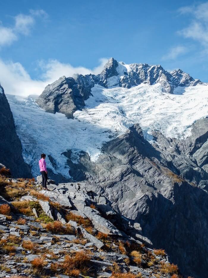
24. Rob Roy Glacier Lookout
The hike to Rob Roy Glacier begins on the West Matukituki Track (like the Mount Aspiring Hut track). After crossing the West Matukituki River on a swing bridge, the trail enters beech forest and follows the Rob Roy Stream.
The final section of the hike takes you through subalpine scrub to the viewpoint of Rob Roy Glacier. The retreating glacier sits above a rock face of cascading waterfalls. This isn’t an overly difficult hike, but you have to be careful with your footing.
Trailhead | Raspberry Creek car park | Google Maps
Distance | 10.6 km out-and-back
Time Needed | 4 hours
Elevation Gain/Loss | 400 m
Difficulty | Moderately difficult
Minimum Elevation | 369 m
Maximum Elevation | 764 m
More Hikes in Mount Aspiring National Park
Mount Aspiring Hut to Dart Hut via Cascade Saddle (Multi-Day Trek). Learn more: DOC Trail Page.
Liverpool Hut (1100 m) – This is a similar hike to that of French Ridge, but an hour shorter. It also departs from Rasberry Creek and follows the same trail as French Ridge, until the river.
Interested in other activities in Mount Aspiring National Park? Check out these guided tours.
Best Base for Hiking in West Matukituki Valley: Wanaka
Budget | YHA Wanaka is a clean and comfortable backpackers’ hostel set in a great location, close to the lake. Guests love the staff, the well-stocked kitchen, communal lounge and dining area, and the rooms. Double rooms available.
Luxury | Edgewater is situated on the shores of Lake Wanaka. The hotel’s restaurant and café are open daily for breakfast, lunch, and dinner. In addition to their seasonal menus, they bake 6 different scones daily and offer Sunday Roast and High Tea, by arrangement. The hotel facilities include a spa, two all-weather tennis courts, a 9 hole putting green, a children’s playground, and a Pétanque.
Look for accommodation in Wanaka.
Best Hikes in Fiordland National Park, South Island

25. Key Summit
This Fiordland National Park hike begins on the Routeburn Track. You’ll gently ascend through a moss-laden forest before reaching the turn-off to Key Summit.
Once you emerge from the tree line, the landscapes transform to boggy subalpine tops sprinkled with tarns
At the top, there’s a circular path that reveals views of Lake Marian, the Darran Mountains, and the Alisa Mountains.
This moderate hike is a good option, especially if you’re cruising Milford Sound in the morning.
Trailhead | The Divide car park | Google Maps
Distance | 8.1 km out-and-back
Time Needed | 3:30 hours
Elevation Gain/Loss | 420 m
Difficulty | Moderate
Minimum Elevation | 536 m
Maximum Elevation | 955 m
More Hikes in Fiordland National Park
Lake Marian (3 hours return) – Trailhead: Hollyford Carpark. Learn more: DOC Trail Page
Gertrude Saddle (4-6 hours return). Learn more: DOC Trail Page
If you are interested in guided hikes in Fiordland National Park, check out these activities.
Best Base for Hiking in Fiordland National Park: Te Anau
Camping | Henry Creek Campsite
Budget | Te Anau Central Backpackers is a clean and cozy hostel in Te Anau, with a shared kitchen, outdoor terrace and garden, and lounge area.
Midrange | Bella Vista Motel Te Anau is a comfortable, smoke-free accommodation, offering studios and one-bedroom units. Breakfast is available upon request.
Luxury | Fiordland Lakeview Motel and Apartments is an aparthotel with outstanding views of Lake Te Anau. All apartments are spacious and have a kitchenette.
Look for accommodation in Fiordland National Park.
Best Hike in Arthur’s Pass National Park, South Island

26. Avalanche Peak
The hike to Avalanche Peak (1833 m) is a strenuous climb. The total elevation gain is 1100 meters. It takes 1:30 – 2 hours to get to the bushline and then another 1:30 hours to the summit.
As you ascend past the bush, you’ll see sweeping views of the river and road winding through the valley. Once you get to the ridge, you’ll be rewarded with panoramic views of the Southern Alps and glacier views. We met a few Keas up on the summit as well.
Trailhead | Arthur’s Pass Visitor Center | Google Maps
Distance | 6.8 km out-and-back
Time Needed | 5-6 hours
Elevation Gain/Loss | 1071 m
Difficulty | Difficult
Minimum Elevation | 745 m
Maximum Elevation | 1833 m
Where to Stay in Arthur’s Pass National Park for Hiking
Camping | Avalanche Creek Shelter Campsite is located right at the trailhead for the Avalanche Peak hike.
Budget | Rata Lodge Accommodation is a quiet, cozy refuge in Otira, a 13-minute drive from Arthur’s Pass. You can stay in a family room, double room, or mixed dormitory. All rooms have access to the communal kitchen and lounge. There are glow worms on the property.
Midrange | Arthurs Pass Motel & Lodge is located directly at Arthur’s Pass, the trailhead to Avalanche Peak and Devils Punchbowl Waterfall. Rooms and units are clean and spacious. There’s a well-equipped communal kitchen and dining room.
Look for accommodation in Arthur’s Pass National Park.

More New Zealand Travel Guides

Pin this Image for Future Trip Planning!
Stay Connected:
Connect with us on Pinterest.
Follow us on Instagram.
Like us on Facebook.
Support Us:
If you love reading our content, you can buy us a coffee via Ko-Fi.
