The Faroe Islands are an archipelago of 18 islands in the North Atlantic Ocean between Iceland and Scotland.
These mountainous islands are unfathomably cinematic, brimming with achingly beautiful nordic landscapes.
Craggy, pyramidal peaks flank serpentine fjords. Frothing waves batter perpendicular cliffs. Grass-roofed cottages cling to coastlines. Puffins, arctic terns, and fulmars sail the winds. And, there’s not a tree in sight.
It’s a raw world of water, grass, and rock, forged by the elements: a paradise for hikers and walkers.
Many hiking trails in the Faroe Islands trace old village paths. Before the construction of tunnels and roads, the Faroese traveled between villages on foot. They used these pathways to visit family, go to church, bury their dead, run errands, and participate in the local parliament (Thing).
The Saksun to Tjørnuvík Hike and Gásadalur Hike are both hikes along ancient village paths. These village trails are open to the public and freely accessible.
Many popular hiking destinations in the Faroe Islands traverse private land. In recent years, landowners have restricted access. Some landowners require payment, while others require guided trips only. For example, hikers must pay a fee to hike to Villingardalsfjall and Trælanípa Cliff (Floating Lake Viewpoint).
In our Faroe Islands hiking guide, we’ve summarized our favorite hikes. Many of these hikes are short. So, it’ll be easy to tackle two hikes per day.
Find out how to string these hikes together in a single trip in our Faroe Islands itinerary.
- When to Hike: June – early/mid September
- When not to Hike: November – December, during hare-hunting season.
- Waymarking: Cairns and small posts
- What to Pack: Gore-Tex (Waterproof) Hiking Boots, Rain Jacket, Puffer, Beanie, Gloves, Hiking Pants
- Car Rental: Use the Discovercars.com car rental reservation platform to search for and book car rentals in the Faroe Islands.
- Best Guided Hiking Tours: Saksun to Tjørnuvík (moderate), Mount Slættaratindur (moderate), Mount Villingardalsfjall (moderately-difficult), Cape Enniberg (demanding), Mikladalur to Trøllanes (demanding)
- Hotels: Best Faroe Islands Hotels
- Where to Stay in Klaksvík: Romantic Klaksvik apartment (midrange), Spacious City Center Home by the Sea (midrange), or Panorama boathouse (luxury)
- Where to Stay in Tórshavn: Hilton Garden Inn Faroe Islands (midrange-luxury), Hotel Brandan (luxury), Havgrím Seaside Hotel 1948 (luxury)
Faroe Islands Hiking Map
10 Best Faroe Islands Hiking Trails
These Faroe Islands hikes are ordered from north to south.
1. Villingardalsfjall Peak Hike, Viðoy Island

Villingardalsfjall (841 meters) is a mountain above Viðareiði, the northernmost village in the Faroe Islands, on Viðoy Island.
The hike to Villingardalsfjall rewards hikers with sweeping views of the cone-shaped Malinsfjall mountain to the south and the islands of Borðoy, Kunoy, and Kalsoy to the west.
The ascent begins moderately, with a mild gradient and grassy terrain. However, as you gain elevation, the mountainside becomes increasingly rugged and rocky. Careful footing and stamina is needed to reach the 841-meters summit.
The trail is marked initially with blue plastic tubes and later with cairns.
Trail Stats
Trailhead | Við Garð Parking Area, Viðareiði, Viðoy Island | Google Maps
Distance | 4.5 km out-and-back
Time Needed | 3:30 – 4 hours
Elevation Gain/Loss | 829 meters
Difficulty | Moderately Difficult
Hiking Fee | 200 DKK per person (cash only)
Guided Hike | If you’re based in Tórshavn, you can book this guided Mount Villingardalsfjall hike, or even better this Cape Enniberg guided hike.
Learn More: Villingardalsfjall Hike
2. Árnafjørður – Toftaskarð – Katlarnir Circuit Trail, Borðoy Island

The Árnafjørður – Toftaskarð – Katlarnir loop hike is the most challenging and off-the-beaten-path trail in this round-up of Faroe Islands hikes.
Starting in the village of Árnafjørður, close to Klaksvík, this lonesome route leads northeast to Svartidalur valley and then climbs up steep crags to Toftaskarð pass.
The trail continues west and eventually drops down a steep mountainside via Uppi á Gjógv pass
Next, the trail steers you to Katlarnir, the historic gathering place for the ancient Thing of the Northern Isles.
From Katlarnir, the trail continues southwest and loops back down to Árnafjørður.
Though extremely exciting, the hike is challenging because of the infrequent waymarking between Árnafjørður and Toftaskarð.
Trail Stats
Trailhead | Árnafjørður Church, Borðoy Island | Google Maps
Distance | 7.7 km circuit
Time Needed | 4 hours
Elevation Gain/Loss | 560 meters
Difficulty | Challenging
Hiking Fee | None
Learn More: Árnafjørður – Toftaskarð – Katlarnir Circuit Trail
3. Klakkur Hike, Borðoy Island

Klakkur (413 meters) is a mountain west of Klaksvík in the Northern Isles.
The Klakkur mountain ridge is long and broad and serves as a bewitching viewpoint of Kunoy Island and Kalsoy Island.
The hike begins with a leisurely stroll along a gravel road, fondly called Ástarbreytin (“Love Path”). This road brings you to Hálsur, the mountain pass between Klakkur and Hálgafelli.
Along the way, there are fantastic views of Klaksvík, wedged between two U-shaped inlets.
From Hálsur, the trail continues north across a boggy area and up a steep hillside to reach the ridge. Pass the transmitter mast and follow the ridge until reaching the obvious viewpoint.
Trail Stats
Trailhead | Water tanks car park, Niðan Horn road, Klaksvík | Google Maps
Distance | 6.2 km out-and-back
Elevation Gain/Loss | 277 meters
Time Needed | 2 Hours
Difficulty | Easy-Moderate
Hiking Fee | None
Learn More: Klakkur Hike
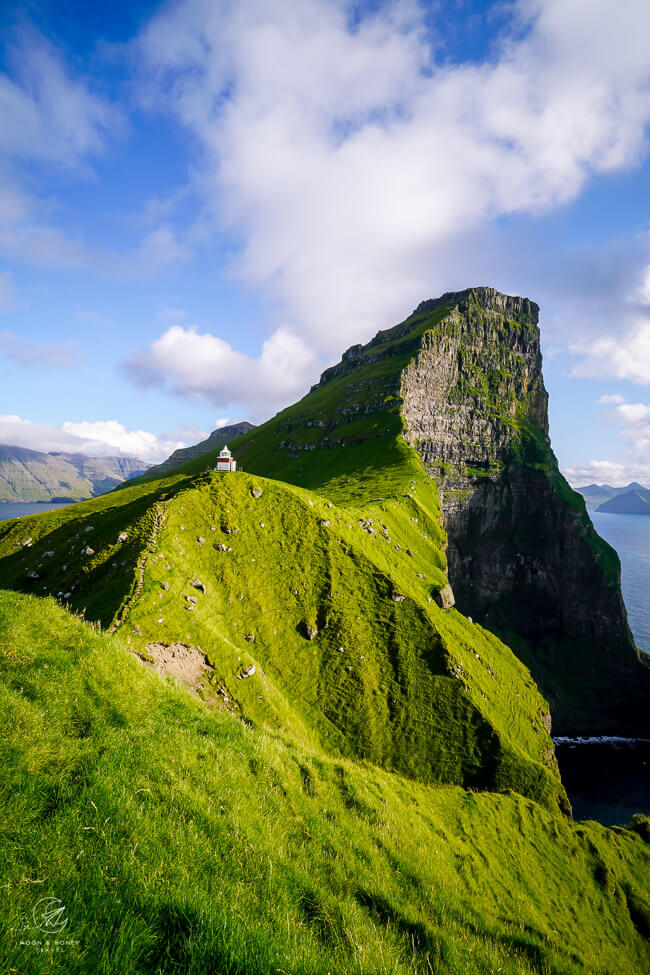
4. Kallur Lighthouse Hike, Kalsoy Island

The Kallur Lighthouse is located in the very north of Kalsoy Island in the Northern Isles. It’s a small white-and-red structure set amid untamed landscapes, both majestic and harsh.
Backed by the fin-shaped Mount Borgarin, Kallur Lighthouse stands proudly on a confluence of falling ridgelines, high above the churning ocean. Undeniably, it’s one of the most captivating scenes in the Faroes.
The hike to Kallur Lighthouse starts in the village of Trøllanes. After entering the outfield, the trail climbs up the hillside and then crosses the eastern flank of Mount Borgarin (537 meters).
When you reach the lighthouse (35-45 minutes), you can continue north along a narrow strip of land to the iconic viewpoint of the lighthouse and Borgarin. Return to the lighthouse and follow the cliffs to the James Bond tombstone. In No Time to Die, James Bond meets his end on Kalsoy Island.
Trail Stats
Trailhead | Trøllanes | Google Maps
Distance | 4.8 km out-and-back
Time Needed | 1:30 hours
Elevation Gain/Loss | 327 meters
Difficulty | Easy-Moderate
Hiking Fee | 200 DKK for Adults and 100 DKK for Children. Credit Cards accepted.
Trail Opening Times | Monday – Friday from 9 am – 6 pm, Saturday from 9 am to 5 pm, and Sunday from 11 am to 5 pm.
Guided Hike | If you don’t want to worry about the logistics of getting to Kalsoy Island, you can also join one of these guided tours:
- Official James Bond Tombstone Tour in the Faroe Islands: 10 hour tour starting and ending in Tórshavn.
- Incredible 8 Hour Guided Tour to Kalsoy & Kallur Lighthouse: 8 hour tour starting and ending in Tórshavn.
- Private 7 Hour Kallur Lighthouse Experience: 7 hour private guided tour starting and ending in Tórshavn.
Learn More: Kallur Lighthouse Hike
5. Hvíthamar Viewpoint Hike, Eysturoy Island

Hvíthamar is a steep mountain wall above Funningur village on Eysturoy Island.
Starting at the Gjáarskarð mountain pass, between the villages of Funningur and Gjógv, you can hike to the Hvíthamar viewpoint in a mere 10 minutes.
This viewpoint overlooks the Funningsfjørður fjord, which flows sinuously to the south between the pyramidal Húsafjall and Dalkinsfjall mountains.
The trail continues another 20 minutes to the higher Skeggjanøv viewpoint.
You can hike straight back down to Gjáarskarð mountain pass to complete the circuit, or follow the ascending route.
Trail Stats
Trailhead | Gjáarskarð mountain pass | Google Maps
Distance | 2 km out-and-back (circuit possible)
Elevation Gain/Loss | 124 meters
Time Needed | 1 hour
Difficulty | Easy
Hiking Fee | None
Learn More: Hvíthamar Viewpoint Hike
6. Saksun to Tjørnuvík Hike, Streymoy Island

Saksun and Tjørnuvík are two picturesque villages in the north of Streymoy Island. These remote settlements are connected by an old village path.
You can start this out-and-back hike in either Saksun (only accessible by car), or Tjørnuvík
Starting in Saksun, the trail rises up the mountainside with views of the Pollurin tidal lagoon.
There’s a large cairn standing on the crest, which marks the beginning of the waymarked village path to Tjørnuvík.
The path climbs up the easterns flank of Frammi í Dal valley to the Tjørnuvíksskarð mountain pass.
From the pass, the trail descends through another high valley, before dropping steeply down to Tjørnuvík village. As you near the village, you’ll see northern Eysturoy and the Risin and Kellingin (Giant and Witch) sea stacks.
Trail Stats
Trailhead | Saksun | Google Maps
Distance | 13 km out-and-back
Time Needed | 5:30 – 6 hours
Elevation Gain/Loss | 1044 meters
Difficulty | Moderate
Hiking Fee | None
Guided Hike | For a guided experience, check out this Hiking from Saksun to Tjørnuvík tour starting in Saksun, or Tórshavn (add-on service).
Learn More: Saksun to Tjørnuvík Hike
7. Múlafossur Waterfall and Gásadalur Hike, Vágar Island

Múlafossur Waterfall (aka Gásadalur Waterfall), located in the remote village of Gásadalur on Vágar Island.
The Múlafossur Waterfall spills over the edge of a grass-carpeted sea cliff into the swelling North Atlantic Ocean below. This dreamlike scene is enhanced by the magical backdrop of Gásadalur village, dwarfed by Heinanøva (612 meters) and Árnafjall (722 meters), the highest mountain on Vágar Island.
You can drive to Gásadalur to see the striking Múlafossur Waterfall. Or, you can follow the old village path from Bøur to Gásadalur.
The hike starts just off Route 45, about 350 meters before the Gásadalstunnilin tunnel entrance. From the trailhead car park, the village path steeply ascends the grassy slopes of Gásadalsbrekkuna (Goosevalley Hill), waymarked with short white poles.
The way rises along the cliffs with views of the Drangarnir sea stack and the Tindhólmur and Gáshólmur Islands.
A long flat stretch brings you to the Á Skarði mountain pass. From here, it’s a steep descent across rugged terrain to Gásadalur village and the Múlafossur Waterfall.
You can return to the starting point along the same route, or hitchhike a ride through the tunnel (what we did).
Trail Stats
Starting Point | Bøur-Gásadalur Trailhead Car Park | Google Maps
Ending Point | Gásadalur Village
Distance | 5.3 km point-to-point
Time Needed | 2 – 2:30 hours
Elevation Gain | 401 meters
Elevation Loss | 521 meters
Difficulty | Moderate – Moderately Difficult
Hiking Fee | None
Learn More: Múlafossur Waterfall and Gásadalur Hike
8. Lake Sørvágsvatn and Trælanípa Cliff Hike, Vágar Island

Lake Sørvágsvatn (also called Lake Leitisvatn) is the largest lake in the Faroe Islands.
However, it’s not famous because of its size, but rather because of its optical illusion. From the Trælanípa cliff on Vágar Island, Lake Sørvágsvatn appears to be floating over the ocean. The surrounding sea cliffs create the impression that the lake is hundreds of meters above sea level. In reality, the elevation difference between the lake and the ocean is only 30 meters.
The hike to Trælanípa cliff starts at a small car park in Miðvágur. After paying the hiking fee (this trail traverses private land), follow the well-trodden trail parallel to Lake Sørvágsvatn in the direction of the coast.
When the path splits at the cliff edge, turn left and climb up to the top of Trælanípa. From this perpendicular sea cliff, you will see the lake above the ocean.
Trail Stats
Trailhead | Trælanípa/Bøsdalafossur car park, Miðvágur | Google Maps
Distance | 6.8 km out-and-back
Time Needed | 1:45 – 2 hours
Elevation Gain/Loss | 110 meters
Difficulty | Easy
Hiking Fee | 200 DKK per person (ages 16+)
Guided Hike | Inspiring 5 Hour Lake Above the Ocean Tour starting in Tórshavn, or The Classic 4 Hour Tour of Vágar Island starting in Miðvágur
Learn More: Lake Sørvágsvatn and Trælanípa Cliff Hike
9. Ásmundarstakkur Hike, Suðuroy Island

Ásmundarstakkur is a 109 meter-high sea stack along the northwest coast of Suðuroy, the southernmost Island in the Faroe Islands.
To reach the Ásmundarstakkur viewpoint(s) and the nearby famous footbridge, drive to the village of Sandvík in Northern Suðuroy.
Park at the parking area on Heiðavegur Road, and follow the gravel road to the northwest coast.
A trail branches off the road and ventures across boggy fields to the cliffs. If visibility is poor, you can stay on the road.
The views of the sea cliffs are phenomenal. If the weather gods are obliging, come here for golden hour to witness a colorful show.
Trail Stats
Trailhead | Heiðavegur road, Sandvík | Google Maps
Distance | 5 km circuit
Time Needed | 1:30 hours
Elevation Gain/Loss | 225 meters
Difficulty | Easy
Hiking Fee | None
Guided Hike | Ásmundarstakkur and Rituskor Tour is a 4-hour tour starting in Tvøroyri on Suðuroy Island.
Learn More: Ásmundarstakkur Hike
10. Hvannhagi and Lake Hvannavatn, Suðuroy Island

Hvannhagi is a remote valley on Suðuroy Island.
Starting in the village of Tvøroyri, it takes 1:25 hours to reach Lake Hvannavatn in Hvannhagi.
We walked along Ovari Vegur Road to reach the trailhead and outfield.
Clearly marked with posts, the path leads northwest and later northeast to a wide pass, where views extend to the small uninhabited islands of Lítla Dímun and Stora Dímun.
After the gate, it’s a slippery descent to Hvannhagi on a rugged path. Follow the obvious footpath to the lake, ringed by steep mountains.
Trail Stats
Trailhead | Tvøroyri | Google Maps
Distance | 7.7 km out-and-back
Time Needed | 3 hours
Elevation Gain/Loss | 278 meters
Difficulty | Moderate
Hiking Fee | None
Learn More: Hvannhagi and Lake Hvannavatn
Responsible Hiking in the Faroe Islands

While hiking in the Faroe Islands, please adhere to these rules of conduct:
1. Follow carins and other trail markers and stay on designated paths only.
2. Do not disturb sheep, birds and plants. Maintain a respectful distance from all animals.
3. It’s illegal to pick plants, or take stones, eggs, or chicks.
4. Close outfield gates behind you.
5. Pick up loose wool that sheep have shed. You can dispose of the wool in a garbage, or keep it. Wool endangers birds, because it gets tangled around their bodies. The weight of the wool makes it difficult, or impossible to fly, and can also cut off the circulation from their legs.
6. Dogs are not allowed in the outfield. Since all hikes in the Faroe Islands lead to the outfield, where dogs are not allowed, hiking with dogs in the Faroe Islands is basically impossible.
7. Do not litter.
8. It’s prohibited to bicycle, or drive any type of motor vehicle into the outfield, or along any cairn path.
9. Do not start a hike when there’s fog, or in the dark.
Where to Stay in the Faroe Islands for Hiking
Tórshavn, Streymoy Island

Tórshavn, the capital of the Faroe Islands, is the most practical base for hiking in the Faroe Islands. Tórshavn offers the most in terms of accommodations and dining, so it makes a lot of sense to stay in the capital for a few nights.
While based in Tórshavn, you can hike the Saksun and Tjørnuvík trail, also located on Streymoy Island.
You can drive through the Vágatunnilin sub-sea tunnel to Vágar Island to hike to Múlafossur Waterfall and Trælanípa Cliff Trail.
You can reach Eysturoy Island by either driving through the Eysturoyartunnilin sub-sea tunnel or crossing the bridge in Sundini. When visiting Eysturoy, we recommend hiking to the Hvíthamar viewpoint on the way to Gjógv. From the idyllic village of Gjógv, follow the coastal cliff trail to see nesting Puffins (summer only).
From Tórshavn, it’s also possible to reach the Northern Isles. However, we think it’s a more efficient to stay 2 nights in Klaksvík to tackle the hikes in the north.
TOP CHOICE – Midrange-Luxury | Hilton Garden Inn Faroe Islands is a fresh-faced hotel set in a quiet location, 1.6 km from the city center (20 minute walk, or 4 minutes drive). Stay here for the impeccably-designed rooms with comfortable beds, the on-site restaurant and bar, great breakfast buffet, and fitness center. Free on-site parking.
Luxury | Hotel Brandan is a 4-star hotel with quiet rooms, an on-site restaurant, a fitness center, a sauna, and on-site parking. Guests love the breakfast and the hotel bar, which serves local craft beers. The hotel is located 1.4 km from the city center (15 minute walk, or 3 minute drive).
Luxury | Havgrím Seaside Hotel 1948 is a boutique hotel set on the seashore, walking distance to the city center (10 minutes). A fantastic breakfast is included. Free parking is available on-site. Guests can also enjoy the garden hot tub facing the sea.
Luxury | Traditional Faroese house in Tórshavns city center is a 4-bedroom turf-roofed house with stylish, renovated interiors, two bathrooms, and a well-equipped kitchen. Free on-site parking. 3 nights minimum stay.
More Charming Holiday Homes: Cosy house in the heart of Tórshavn (Á Reyni) and Luxurious House in Downtown Tórshavn
City Center Apartments: City center, Tórshavn (2-bedroom apartment), Central apartment in Tórshavn (1-bedroom apartment), Penthouse Apartment in Downtown Tórshavn (3-bedroom/5 people apartment)
Look for accommodation in Tórshavn.
Learn More: Best Faroe Islands Hotels
Klaksvík, Borðoy Island
Klaksvík, located on Borðoy island, is the second largest town in the Faroe Islands. It’s the best base for exploring the Northern Isles: Kalsoy, Borðoy, Kunoy, and Viðoy.
While based in Klaksvík, you can hike up to Klakkur Mountain and head to nearby Árnafjørður village to hike up to Toftaskarð and Katlarnir.
You can take the ferry from Klaksvík to Kalsoy Island in order to hike to Kallur Lighthouse.
And, you can drive (or take the bus) all the way to Viðareiði village on Viðoy Island to summit Villingardalsfjall.
We recommend spending 2 nights in Klaksvík.
Midrange | The welcoming and cozy Romantic Klaksvik apartment is a one-bedroom apartment with a fully-equipped kitchen, living room, garden, and private parking. The apartment is walking distance to the Kalsoy ferry.
Midrange | Spacious City Center Home by the Sea is located in the heart of Klaksvík, close to Fríða Kaffihús, tourist office, Kalsoy ferry terminal, and grocery store. This roomy and bright 3-bedroom apartment has a fully-equipped kitchen (with dishwasher and microwave), a washing machine, balcony, and free parking.
Top Choice – Luxury | Set along Klaksvík bay, Panorama boathouse stands out with its crisp, modern aesthetic, new furnishings, and idyllic setting. This beautifully converted boathouse has 3 bedrooms, a well-equipped kitchen, a washing machine, a spacious dining area, and a living room.
Look for accommodation in Klaksvík.
Suðuroy Island
Suðuroy is the southernmost island in the Faroe Islands. Because, it’s a 2-hour ferry ride from Tórshavn to Tvøroyri, Suðuroy, we recommend spending 1-2 nights on the island.
It only takes 45 minutes to drive the full length of Suðuroy from Sumba in the south to Sandvík in the north. So, wherever you stay on the Island, you’re within easy driving distance to other villages and attractions.
During your visit, prioritize the hikes to Ásmundarstakkur viewpoint and Hvannhagi valley.
We stayed in BRIM B&B, which is a darling bed and breakfast in Vágur. Another option in Vágur is Lovely Holiday Home in Vágur with Hot Tub and Sauna.
You can also stay in Tvøroyri at this Nice one-story house in Suduroy (2 nights minimum stay).

Faroe Islands Travel Essentials
Faroe Islands Rental Car
The most practical way to travel between destinations in the Faroe Islands is with your own car. Plan your trip with our Faroe Islands road trip itinerary.
We recommend using the Discovercars.com car rental reservation platform to search for and book car rentals in the Faroe Islands. This easy-to-use booking platform compares car rental deals from 500+ trusted providers, so that you can choose the best option for your trip.
You can also book a complete self drive vacation package, which includes accommodation, car rental, and various guided day tours:
- Epic 8 Day Summer Self Drive Tour of Faroe Islands
- Unforgettable 10 Day Self Drive Tour of Faroe Islands with Top Attractions
Adventurous Faroe Islands Tours
- Panoramic 6 Hour Tour to Mount Slættaratindur: hike to the summit of Mount Slættaratindur, the highest mountain in the Faroes. This guided tour starts in Tórshavn.
- Wild 8 hour Hike to Cape Enniberg: hike to Mount Villingardalsfjall and onwards to Cape Enniberg (only possible with a guide), one of the highest promontories in the world, on Viðoy Island. This guided excursion starts in Tórshavn.
- Kayaking to Drangarnir: 2:30 hour kayak tour of the Drangarnir sea arch starting in the village of Bøur on Vágar Island.
- Exciting 2 Hour Combined Boat Tour and Hike to Drangarnir Sea Arch: 2 hour tour starting in Sørvágur harbor on Vágar Island.
- Hike from Mikladalur to Trøllanes: 8 hour guided hike on Kalsoy Island starting in Klaksvík, Borðoy Island.
Faroe Islands Guided Day Trips
Here are some popular guided day trips starting and ending in Tórshavn.
- The Northern Islands and Tjørnuvík: 9 hour guided tour of the Northern Isles.
- The Classic Mykines Tour: 6 hour guided tour of Mykines Island.
- Popular 7.5 Hour Vestmanna Bird Cliffs & Múlafossur Waterfall Tour: 7:30 hour guided tour including a boat tour of Vestmanna cliffs.
- Incredible 8 hour Guided Tour to Kalsoy & Kallur Lighthouse: 8 hour guided tour of Kallur Island.
Outdoor Photographer Gear
- Camera Body: Sony Alpha a6400
- Mid-range Zoom Lens: Tamron 17-70mm 2.8 Di III-A VC RXD
- Wide angle Zoom Lens: Sony – E 10-18mm F4 OSS Wide-angle Zoom Lens
- Backpack Camera Clip: Peak Design Camera Clip
Pin this Image for Future Trip Planning!
Stay Connected:
Connect with us on Pinterest.
Follow us on Instagram.
Like us on Facebook.
Support Us:
If you love reading our content, you can buy us a coffee via Ko-Fi.
