Austria’s Grossglockner High Alpine Road (Großglockner Hochalpenstraße in German) is a paved serpentine road that steers you into the heart of Hohe Tauern National Park in the Austrian Alps and directly to the base of the Grossglockner (3798 m), Austria’s highest mountain.
This is simply one of Europe’s finest mountain roads. Panoramic views of Austria’s highest peaks encircle you as you drive deeper into the High Tauern mountains.
Highly accessible, although pricey, the Großglockner Hochalpenstraße is an unforgettable way to spend a day.
Construction on this 48-km road began in 1930 and was completed five years later. Today, 900,000 people visit each year.
The Grossglockner High Alpine Road connects Fusch an der Großglocknerstraße in Salzburg with Heiligenblut am Großglockner in Carinthia.
You can drive in either direction, as no particular direction is more beautiful.
Find out how to integrate the Großglockner High Alpine Road into a 14 Day Austria Road Trip and a 7 Day Austria Road Trip.
- Road Length: 48 km
- Opening Times: Early-mid May until Early November, weather depending. Check opening times.
- Pricing: 43 EUR for private cars, 33 EUR for motorcycles
- North Entrance: Fusch an der Großglocknerstraße in Salzburg
- South Entrance: Heiligenblut am Großglockner in Carinthia
- Must-do hike: Glacier Trail Pasterze
- Where to Stay: Panoramarestaurant Kaiser Franz-Josefs-Höhe (budget), or Wallackhaus RegioJet Hotels (midrange) located on the high alpine road
- Recommended Trail Map: Großglockner WK 120 1:50 000 (Freytag + Berndt)
Grossglockner High Alpine Road Map
The Grossglockner High Alpine Road is highlighted in grey. Hiking trails are highlighted in blue and places to stay are marked in black.
When Can You Drive the Grossglockner High Alpine Road?

This scenic route through Hohe Tauern National Park is generally open from early-mid May until early November.
When we visited in mid-June, the road conditions were perfect. However, because of the long winter, some hiking trails were still closed.
In terms of time or day, the road is open roughly from sunrise to sunset.
Early May – May 31 | 6:00 a.m. – 8:00 p.m. (Last entrance: 7:15 p.m.)
June 1 – August 31 | 5:30 a.m. – 9:00 p.m. (Last entrance: 8:15 p.m.)
September 1 – Early November | 6:00 a.m. – 7:30 p.m. (Last entrance: 6:45 p.m.)

How Much Is the Grossglockner High Alpine Road?

As of 2024, driving the Grossglockner High Alpine Road costs 43 EUR for private cars and 33 EUR for motorcycles.
You’ll pay less, if you drive an electric or hydrogen vehicle (no hybrid vehicle gets the discount though). See pricing table.
It’s possible to purchase tickets in advance from the Grossglockner Hochalpenstraße Online Shop.
There’s a toll station located near Wildpark Ferleiten if you’re driving from Salzburg (North), and another one near Heiligenblut, if you’re driving from Carinthia (South).
Good to know | If you stay overnight along the Grossglockner High Alpine Road, you do not have to pay additional fees on your day of departure.
If you have a SalzburgerLand Card, you can choose between one free drive along the Grossglockner High Alpine Road (like we did), or a 24-hour Salzburg City Card.
The SalzburgerLand Card grants guests free or discounted access to 190 attractions across the state of Salzburg. You can choose between a 6-day card or a 12-day card (see pricing here). It’s a great deal if you’re planning on doing a lot of activities in Salzburg.
Where to Stop along the Grossglockner High Alpine Road?

The most notable stops along the Grossglockner High Alpine Road are:
Edelweiss-Spitze (2571 m) – Highest vantage point along the High Alpine Road. The turnoff to Edelweiss Spitze is signed. You’ll find a large parking lot by Restaurant Fuschertörl, but continue driving up the narrow road to Edelweiss-Spitze. Exact Location: Google Maps
Glocknerhaus (2132 m) – Trailhead Glacier Trail Pasterze, and a great place to have lunch. Exact Location: Google Maps
Nassfeld Speicher (2233 m) – A small lake fed by two waterfalls just off the road between the Glocknerhaus and Kaiser Franz Josefs Höhe. Exact Location: Google Maps
Kaiser Franz Josefs Höhe (2369 m) – Lookout Point of Grossglockner and rapidly receding Pasterze Glacier. There is a visitor center and a large parking garage here. This is the starting point for the Gamsgrubenweg. Exact Location: Google Maps
Read Next: Best Places to Visit in Austria
Where to Hike along the Grossglockner High Alpine Road?
Glacier Trail Pasterze Circuit Trail

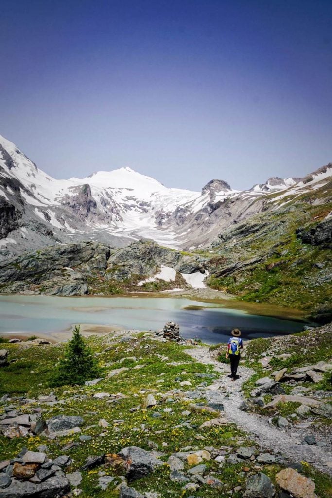
The Glacier Trail Pasterze (Gletscherweg Pasterze) from Glocknerhaus to Kaiser-Franz-Josefs-Höhe is an absolute must. Well-marked and easy-to-follow, this moderate circuit hike takes 3 hours.
The circuit trail is also part of the first stage of the Alpe Adria long-distance trail, which starts at Kaiser-Franz-Josefs-Höhe and ends in Heiligenblut.
Though you can hike in either direction, we recommend starting in Glocknerhaus, because the views unfold spectacularly as you near the foot of Grossglockner.

Initially, the trail descends from Glocknerhaus to the reservoir Margaritzenstausee and then continues left along the water and over two reservoir cement walls. The water of Pasterze Glacier feeds Margaritzenstausee.
Next, the trail ascends to Sandersee (lake). From here, you’ll have a great view of Pasterze and Grossglockner.
Continue all the way up to Kaiser-Franz-Josefs-Höhe. It’s possible to take a regional bus back to Glocknerhaus. However, these busses are very infrequent (max 3 per day).
Inside Glocknerhaus, there’s a timetable for the regional bus, which you can check before you set off.

Trail Stats
Trailhead | Glocknerhaus Kärnten | Google Maps
Distance | 7.8 km circuit
Time Needed | 3 hours
Elevation Gain/Loss | 444 meters
Difficulty | Moderate
Minimum Elevation | 1991 meters
Maximum Elevation | 2370 meters
Route | Glocknerhaus – Margaritzenstausee – Sandersee – Franz-Josefs-Höhe – Pasterzenhaus – Glocknerhaus
Gamsgrubenweg
This 1:30-hour hike starts at Kaiser-Franz-Josefs-Höhe. The trail is suitable for everyone. A series of tunnels (6 total) usher you closer to a Pasterze Viewpoint (Wasserfallwinkel).
The panoramic views from the Gamsgrubenweg trail look stunning.
Unfortunately, the tunnels were closed during our visit, because of ice and snow. Next time!
Update | In recent years, the Gamsgrubenweg has only been accessible as far as Tunnel 6. The continuation to Wasserfallwinkel and Oberwalderhütte is only recommended for alpinists with appropriate mountaineering equipment (helmet!) due to the high risk of falling rocks.
Tip | Between early July and mid-September, you can join a free guided hike (2 hours) with a national park ranger daily at 10:30 am and 1:30 pm. The meeting point is at the information desk at the Kaiser-Franz-Josefs-Höhe visitor center. Please confirm hiking time and dates with the local tourist office.
Trail Stats
Trailhead | Kaiser Franz-Josefs-Höhe | Google Maps
Distance | 5.3 km out-and-back
Time Needed | 1:30 hours
Elevation Gain/Loss | 200 meters
Difficulty | Easy
Minimum Elevation | 2369 meters
Maximum Elevation | 2551 meters
Hike to Brennkogel Peak
This 3:30-hour hike (out-and-back) begins at Hochtor and ascends to Brennkogel (3,018 m). Follow the the “Klagenfurter Jubiliäumsweg”. After 2 km (45 minutes), it passes Brettersee, a crystal clear mountain lake.
Another 1 hour of hiking brings you to the summit of Brennkogel (also called Goldberg).
Unfortunately, this trail was also closed during our visit in mid-June.
Trail Stats
Trailhead | Parking Hochtor | Google Maps
Distance | 7.8 km out-and-back
Time Needed | 3:30 hours
Elevation Gain/Loss | 767 meters
Difficulty | Moderately difficult
Minimum Elevation | 2506 meters
Maximum Elevation | 3018 meters
Read Next: Best Hikes in Salzburg
Tips for Hiking in Hohe Tauern National Park
Pack snacks and sufficient water.
Wear Grade B/C hiking boots like the women’s Hanwag Tatra II GTX / Meindl Island Lady (what Kati and I wear) or the men’s Hanwag Tatra II GTX.
Use Maps.me (offline maps app) to locate trails and trailheads.
Get a hiking map: Großglockner WK 120 1:50 000 (Freytag + Berndt)
Hike with a ranger or mountain guide: Guided tours in the Hohe Tauern National Park
Where to Eat along the Grossglockner High Alpine Road?

There are many places to stop and grab a bite to eat along the route. You can eat at Restaurant Fuschertörl or Edelweisshütte at Edelweiss-Spitze.
Other options include Haus Alpine Naturschau, Römerhütte, Restaurant Fuscher Lacke, Restaurant Schöneck, Knappkasa, and Karl-Volkert-Haus.
It’s also possible to eat at Kaiser Franz Josefs Höhe, where you’ll find Restaurant Kaiser Franz Josef Haus and Panoramarestaurant and Restaurant Freiwandeck.
We ate a delicious lunch at Glocknerhaus after finishing our hike to Sandersee.
Where to Stay along the Grossglockner High Alpine Road
If you’re trying to figure out where to stay before, or after driving the Grossglockner alpine road, consider Heiligenblut (south entrance to the alpine road) and Fusch an der Großglocknerstraße (north entrance).
If you’re planning a road trip through Austria, this is something you’ll definitely want to include in your itinerary.
The following guesthouses and hotels are all located directly on the Grossglockner High Alpine Road.
Midrange | Berggasthof Wallackhaus is the best place to stay if you want to experience sunset and sunrise along the Grossglockner route. With its unbeatable location, you can extend your exploration of the area and relish the Hohe Tauern mountains from your hotel room. Breakfast included.
Midrange | The Panoramarestaurant Kaiser Franz-Josefs-Höhe offers comfortable double or twin rooms, which include breakfast on request. You can eat dinner at the on-site restaurant. Located directly at the Franz-Josefs-Höhe, the location of this accommodation could not be better. Great value for money!
Look for accommodation along the Großglockner Hochalpenstraße.

Austria Trip Planning Essentials
Use our Austria Travel Guide and Austria blog archive to plan a unique and memorable trip to Austria.
When to Visit Austria
Summer and early Fall are our favorite seasons in Austria.
Getting around Austria
Austria has an excellent public transit system. We’ve used it extensively to travel throughout the country. We highly recommend using transit if you’re visiting cities (Vienna, Salzburg, Innsbruck, Graz, etc…), and/or doing hut-to-hut hikes.
Some areas like Mayrhofen, Schladming and Lech am Arlberg have wonderful seasonal transit systems in place (e.g. summer hiking buses). However, if you’re not visiting during the high season, bus frequencies are significantly reduced and it’s far easier to get around with your own vehicle.
If you’re planning on visiting multiple destinations across Austria, we recommend renting a car.
Use these road trip itineraries for trip planning inspiration:
- 2 Week Austria Road Trip – starting in Vienna
- 1 Week Austria Road Trip – starting in Salzburg or Munich
- 10-Day Bavarian Alps & Tyrolean Alps Road Trip – starting in Munich
Car Rental
We recommend using the Discovercars.com car rental reservation platform to search for and book car rentals. This easy-to-use booking platform compares car rental deals from 500+ trusted providers, so that you can choose the best option for your trip.
If you’re driving into Austria from a neighboring country, don’t forget to purchase a vignette at/near the border.
Hiking in Austria
Where to Hike in Austria
Read Austrian Alps Hiking Destinations for an overview of where to hike in Austria, with tips on specific trails and where to stay. Also check out Best Day Hikes in Austria and these region-specific hiking guides:
- Innsbruck Hiking Guide
- Salzburg Hiking Guide
- Filzmoos, Salzburg Hiking Guide
- Schladming, Styria Hiking Guide
- Lech am Arlberg, Vorarlberg Hiking Guide
- Vorarlberg Hiking Guide
- Vienna Mountains Hiking Guide
Hut to Hut Hiking in Austria
Austria is a premier hut-to-hut and long-distance hiking destination. The quality of the mountain huts are superb. We particularly love the high-alpine trails, which are called Höhenwege in German. We’ve summarized our favorite multi-day hikes in Trekking Austria. If you’re new to hut hiking, read this in-depth guide to Hut to Hut Hiking in Austria.
Hiking Essentials
- Trekking Pack: Osprey Kyte 36 – women / Osprey Kestrel 38 -men
- Day Pack: Osprey Tempest 30 Women’s Backpack / Osprey Talon 33 Men’s Backpack
- Grade B/C high-cut hiking boots: Meindl Schuhe Island Lady (Kati’s Boots), Women’s Hanwag Tatra II GTX (Sabrina’s Boots), Men’s Hanwag Tatra II GTX (men’s equivalent)
- CAT 4 Sunglasses: Julbo Shield Mountain Sunglasses
- Hiking Poles: Black Diamond Trail Trekking Poles
- Backpack Camera Clip: Peak Design Camera Clip
What to See & Do in Austria
- Visit a gorge like the Liechtenstein Gorge in Salzburg, or the Wolfsklamm Gorge in Tirol.
- Bathe in the thermal pools of an Austrian Therme like Aqua Dome in Tirol.
- Stay in a thermal spa hotel like Rogner Bad Blumau in Styria, EurothermenResort Bad Ischl in Upper Austria, or the Aqua Dome Hotel in Tirol.
- Hike to a mountain lake like Lake Tappenkarsee in Salzburg or Lake Drachensee in Tirol.
- Go Wine Tasting in South Styria.
- Marvel at the culture, music, and architecture of Vienna.
- Eat heartwarming mountain food in an Almhütte at Grosser Ahornboden in Tirol or Ursprungalm in Styria.
- Drive the Grossglockner High Alpine Road in Hohe Tauern National Park.
- Visit the castles, monasteries, and wine taverns of the Wachau Valley, a UNESCO World Heritage Site.
Austrian Hotels
- Best Hotels in the Austrian Alps
- Best Hotels in Lech am Arlberg, Vorarlberg
- Wellness Hotel Theresa, Zillertal, Tirol
- Hotel Eder in Maria Alm, Salzburg

Hello, is there an address that can help me find more information about the hike you mentioned starting Glocknerhaus to Kaiser-Franz-Josefs-Höhe? GPS coordinates? Parking Lot address? Thanks!
Hi Sally,
Glocknerhaus: Gletscherstraße, 6844 Heiligenblut.
You can easily find the location in Google Maps.
Hi, Kati and Sabrina!
thank you for your wonderful website with all the useful info, beautiful pictures and great recommendations. I did go through many of your articles but I still wanted to ask you for an advice.
I’m doing an alta Via 2 on July 8th, prior to that I will do a Hut-To-Hut Traverse Across Tre Cime Nature Park from July 1st to 4th,. But I also have a week in Austria from June 24th to June 30th, and I want to plan another track. I don’t want it to be too easy nor too difficult, because I don’t want to exhaust myself.
If you were to choose one track in Austria for 5-7 days, prior to the tracks I mentioned, which one would it be ?
I was looking at Grossglockner loop, do you think it’s a good track ? Or should I do a Ratikon Hight trail instead? Or maybe Schladming loop? ( or will it be to early for the last track?)
Thank you for your time!
Hi Irena,
We love the Rätikon Alps High Trail. It’s an absolute pleasure to hike.
We haven’t hiked the Grossglockner Loop.
Schladminger Tauern and the other treks we’ve written about are significantly more difficult than the Rätikon Alps trek and Alta Via 1 trek. So as long as you’re up for a bit more technical hiking, I would say go for it! The mountains of Schladming are not as dramatic comparatively, but the lakes along the route are a dream.
happy hiking,
Sabrina