Drachensee (1874 m) and Seebensee (1657 m) are two mountain lakes in the Mieminger Chain in the Tyrolean Zugspitz Arena region in Austria.
Lake Drachensee (“Dragon Lake”) is ringed by rugged, limestone peaks – pale in color and formidable in shape. Around the lake, dwarf-pine carpeted slopes spill into its crystal-clear, teal waters. It’s an impressive landscape shared only by the Coburger Hütte mountain refuge (1917 m), which is perched above the lake.
Not too far below Lake Drachensee lies Lake Seebensee, set between Vorderen Tajakopf, Vorderen Drachenkopf, and the Ehrwalder Sonnenspitze. From Lake Seebensee, you can enjoy riveting views of the Wetterstein Mountains.
A highly-gratifying circuit trail around Tajakopf mountain links the Ehrwald alpine pasture (accessible by cableway) with these two alpine lakes as well as Lake Brendlsee.
By following the Tajakopf circuit route, you’ll avoid most of the crowds, as the vast majority of visitors opt for an out-and-back hike to Seebensee and Drachensee via the Seebenalm alpine pasture.
The circuit is also more interesting and affords the best views of Drachensee. The key is to hike it clockwise, so you can face Lake Drachensee on your way down from the Tajatörl saddle.
Given the popularity of this Ehrwald destination, we highly recommend visiting off-season and during the week. Start as early as possible to avoid the mid-morning rush.
- Trailhead: Ehrwalder Almbahn mountain station
- Distance: 14.9 km lollipop-circuit
- Time needed: 5:30 hours
- Elevation Gain/Loss: 909 meters
- Difficulty: Moderate – Moderately Difficult
- Minimum Elevation: 1498 meters
- Maximum Elevation: 2260 meters
- When to Hike: June – October
- Where to Eat: Coburger hut, or at Ehrwalder Alm
- Where to Stay: Mellow Mountain Hostel (budget), der grüne Baum Mountain Boutique Hotel (midrange), Romantik Hotel Spielmann (luxury) in Ehrwald
- Recommended Hiking Map: WK 352 Ehrwald Wanderkarte 1:50 000 (Freytag + Berndt)
Drachensee and Seebensee Hiking Map
Where to Start the Hike to Lake Drachensee and Lake Seebensee

Ehrwald Almbahn
Park your car at the parking lot of the Ehrwalder Almbahn, which is located just outside Ehrwald. Buy a parking ticket (5 EUR/day) from a machine at the parking lot.
Location | Dr. Ludwig Ganghoferstr 66, 6632 Ehrwald | Google Maps
Round-Trip Ticket | Purchase a round-trip ticket to the Ehrwald Almbahn mountain station. By ascending to the Ehrwald Alp by cableway, you’ll shave off 400 meters of elevation gain and save a lot of time. A round-trip ticket costs 21.50 EUR per person.
Summer Opening Times | May 9 – November 3, 2024. Confirm opening times on almbahn.at.
Operating Hours | In high season (July – September): 8 am – 5:30 pm. In low season (June, October, November): 8:30 am – 4:30 pm.
Drachensee and Coburger Hut Trail Description
Ehrwalder Almbahn mountain station to Brendlkar/Ganghofersteig Intersection (45 minutes)

From the mountain station, follow the wide gravel road southeast in the direction of the Coburger Hütte. After passing the Gasthof Alpenglühn, the track ascends along a few serpentines.
Along this forest road, you’ll encounter a few intersections. Always follow signs to Brendlkar and Tajatörl.
The path leaves the gravel road and continues gently on a narrow path for about 10 minutes, passing through an alpine pasture gate.
When you reach the next trail junction, turn left to Brenklkar (1 hour) and Tajatörl (2 hours).
This is the Ganghofersteig trail.
Note: If you continue right to Seeben-Alm and Coburger Hütte, you’ll miss the best part of the hike.
Brendlkar/Ganghofersteig Intersection to Hinteres Tajatörl (1:40 hours)

The Ganghofersteig mountain trail initially ascends through the forest. Once you rise above the larches, you’ll be met with unobstructed views of the Wetterstein mountains to the north.
The friendly path suddenly turns to scree. Follow the steep, well-established track up the scree slope.

After a good 10 minutes, the trail grade lessens and leads diagonally across a grassy slope to Lake Brendlsee.
The trail continues east easily amidst a boulder-studded landscape punctured by limestone sinkholes.
The two Tajaköpfe peaks are located directly to your right.

At about 2000 m, the trail makes a right turn and now climbs steadily towards Hinteres Tajatörl saddle, which means “rear taja door/gate.”
Here we spotted numerous foraging chamois.

The trail gets increasingly rocky as you near the Hinteres Tajatörl (2259 m), the highest point of this trail.
You’ll crest the saddle after conquering a series of scree switchbacks.
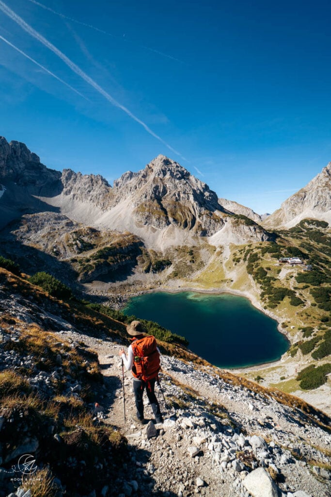
Hinteres Tajatörl to Coburger Mountain Hut (1:10 hours)

From Hinteres Tajatörl, follow the path straight ahead. Soon, you’ll see Ehrwalder Sonnenspitze and Drachenkopf towering above the teal Lake Drachensee.
The trail follows a rise southwest for about 450 meters, before turning right, and starting the descent to the lake.
The descent is very manageable. However, hiking poles will help with stabilization, as the trail is strewn with loose rocks.

As you hike downhill, you’ll enjoy constant views of Lake Drachensee.
The path cruises down to the lakeshore and then makes a short counter-ascent to the managed Coburger mountain hut.

Coburger Hut to Lake Seebensee (30 minutes)

Follow the signs in the direction of Ehrwalder Alm.
You can already see Seebensee below.
The descent from Coburger Hut is steep, narrow and rocky. This part of the route can feel like a highway, since so many people are hiking between these two lakes.
Lake Seebensee (1660 m) is a lovely place for a break. There are benches along the southern shore that invite you to rest.
Lake Seebensee to Ehrwalder Almbahn (1:15 hours)

Follow the wide gravel road around the lake and then onwards to the Seebenalm alpine pasture.
Stay on the road and then hike through a beautiful forest until you reach the already known turnoff towards Ganghofersteig/Brendlkar.
We turned left here towards “Koatiger Weg, Ehrwalder Alm”. However, we don’t recommend this route as it’s very slippery and steep.
Follow the familiar forest road back to the Ehrwalder Almbahn mountain station.
Where to Stay in Ehrwald
Budget | The spotless and charming Mellow Mountain Hostel has a range of bedrooms: double and triple rooms as well as 4-person and 6-person dormitories. Guests have access to a shared kitchen, sauna, and cozy living space.
Midrange | Der Grüne Baum Hotel is a comfortable, boutique hotel in the center of Ehrwald. With its fresh Tyrolean interiors, modern spa oasis, and in-house restaurant, it strikes just the right balance between urban and nature. Guests can choose between breakfast-only, or half board.
Luxury | The historic, family-run Romantik Hotel Spielmann is beautifully put together, with an ivy-covered facade accented by painted window frames and rustic Tyrolean interiors. Highlights of staying here are the sensational mountain views, excellent service, delicious food, and the new wellness area comprising a mountain-facing infinity rock pool and numerous saunas.
Look for accommodation in Ehrwald.
More Hikes Near Drachensee
Nearby Adventures in the Bavarian Alps:
- Best Things to Do in Garmisch-Partenkirchen
- Best Hikes in Garmisch-Partenkirchen
- Lake Eibsee
- Partnach Gorge Hike
- Alpspitze Via Ferrata
- Kreuzeck to Höllentalklamm Gorge Hike

Austria Trip Planning Essentials
Use our Austria Travel Guide and Austria blog archive to plan a unique and memorable trip to Austria.
When to Visit Austria
Summer and early Fall are our favorite seasons in Austria.
Getting around Austria
Austria has an excellent public transit system. We’ve used it extensively to travel throughout the country. We highly recommend using transit if you’re visiting cities (Vienna, Salzburg, Innsbruck, Graz, etc…), and/or doing hut-to-hut hikes.
Some areas like Mayrhofen, Schladming and Lech am Arlberg have wonderful seasonal transit systems in place (e.g. summer hiking buses). However, if you’re not visiting during the high season, bus frequencies are significantly reduced and it’s far easier to get around with your own vehicle.
If you’re planning on visiting multiple destinations across Austria, we recommend renting a car.
Use these road trip itineraries for trip planning inspiration:
- 2 Week Austria Road Trip – starting in Vienna
- 1 Week Austria Road Trip – starting in Salzburg or Munich
- 10-Day Bavarian Alps & Tyrolean Alps Road Trip – starting in Munich
Car Rental
We recommend using the Discovercars.com car rental reservation platform to search for and book car rentals. This easy-to-use booking platform compares car rental deals from 500+ trusted providers, so that you can choose the best option for your trip.
If you’re driving into Austria from a neighboring country, don’t forget to purchase a vignette at/near the border.
Hiking in Austria
Where to Hike in Austria
Read Austrian Alps Hiking Destinations for an overview of where to hike in Austria, with tips on specific trails and where to stay. Also check out Best Day Hikes in Austria and these region-specific hiking guides:
- Innsbruck Hikes
- Salzburg Hikes
- Filzmoos Hikes
- Schladming Hikes
- Lech am Arlberg Hikes
- Vorarlberg Hikes
- Vienna Mountains Hikes
Hut to Hut Hiking in Austria
Austria is a premier hut-to-hut and long-distance hiking destination. The quality of the mountain huts are superb. We particularly love the high-alpine trails, which are called Höhenwege in German. We’ve summarized our favorite multi-day hikes in Trekking Austria. If you’re new to hut hiking, read this in-depth guide to Hut to Hut Hiking in Austria.
Hiking Essentials
- Day Pack: Osprey Tempest 30 Women’s Backpack / Osprey Talon 33 Men’s Backpack
- Grade B/C high-cut hiking boots: Meindl Schuhe Island Lady (Kati’s Boots), Women’s Hanwag Tatra II GTX (Sabrina’s Boots), Men’s Hanwag Tatra II GTX (men’s equivalent)
- CAT 4 Sunglasses: Julbo Shield Mountain Sunglasses
- Hiking Poles: Black Diamond Trail Trekking Poles
- Backpack Camera Clip: Peak Design Camera Clip
What to See & Do in Austria
- Visit a gorge like the Liechtenstein Gorge in Salzburg.
- Bathe in the thermal pools of an Austrian Therme like Aqua Dome in Tirol
- Stay in a thermal spa hotel like Rogner Bad Blumau in Styria, EurothermenResort Bad Ischl in Upper Austria, or the Aqua Dome Hotel in Tirol.
- Hike to a mountain lake like Lake Tappenkarsee in Salzburg, or Lake Drachensee in Tirol.
- Go Wine Tasting in South Styria.
- Marvel at the culture, music, and architecture of Vienna.
- Eat heartwarming mountain food in an Almhütte at Grosser Ahornboden in Tirol or Ursprungalm in Styria.
- Drive the Grossglockner High Alpine Road in Hohe Tauern National Park.
- Visit the castles, monasteries, and wine taverns of the Wachau Valley, a UNESCO World Heritage Site.
Austrian Hotels
- Best Hotels in the Austrian Alps
- Best Hotels in Lech am Arlberg, Vorarlberg
- Wellness Hotel Theresa, Zillertal, Tirol
- Hotel Eder in Maria Alm, Salzburg
