Hiking in Tenerife convinced us that the Canary Islands are one of the best hiking destinations in Europe, especially in winter.
From sweeping volcanic landscapes evocative of Mars to rolling verdant mountains that unfurl into the sea, this island enchants at every turn.
The most impressive hiking trails in Tenerife are concentrated in Anaga Rural Park, Teide National Park, and the Teno mountains.
We recommend spending at least one week on the island to sample each of these regions, as outlined in this Tenerife road trip itinerary.
This Tenerife hiking guide provides an overview of our favorite trails on the island, with links to more in-depth posts.
Important: Access to these Tenerife hiking trails keeps changing due to landslides and construction. We highly recommend reaching out to local tourist offices to confirm whether these trails are open during your visit.
Tenerife Hiking Tips
- One of the most popular hikes in Tenerife is Pico del Teide (Mount Teide Peak). If you want to summit Teide, you need a permit. We’ve compiled everything you need to know about this hike in our guide to Visiting Mount Teide National Park.
- Purchase a Tenerife hiking guidebook like the Tenerife Rother Walking Guide before you arrive in Tenerife. It’s really difficult to find helpful trail guides once you’re on the island.
- Pack hiking snacks and sufficient water for every hike. Even though there are restaurants scattered across the Tenerife mountains, they’re not always open.
- Wear Grade B or B/C hiking boots. You need sturdy shoes to tackle steep and slippery terrain (e.g. scree and wet leaves)
- Use a mobile trail app with offline maps to locate trailheads.
- Base yourself in La Laguna for hiking in the Anaga Mountains, Buenavista del Norte or Los Gigantes for exploring Teno Rural Park, and Vilaflor for hiking in Teide National Park. More info: Where to Stay in Tenerife for Hiking.
- Recommended Trail Maps: Tenerife Hiking Map Set WKE 7 (Freytag + Berndt)
Tenerife Hiking Map
How to Reach Tenerife Trailheads
The most efficient way to travel between hiking destinations in Tenerife is with your own car. We’ve tied together all the best Tenerife hiking destinations in this 1 Week Tenerife Road Trip.
We recommend using the Discovercars.com car rental reservation platform to search for and book car rentals in Tenerife. This easy-to-use booking platform compares car rental deals from 500+ trusted providers, so that you can choose the best option for your trip.
Tip: If you can only drive automatic transmission cars, as opposed to manual transmission cars (stick shift), book your can rental as early as possible.
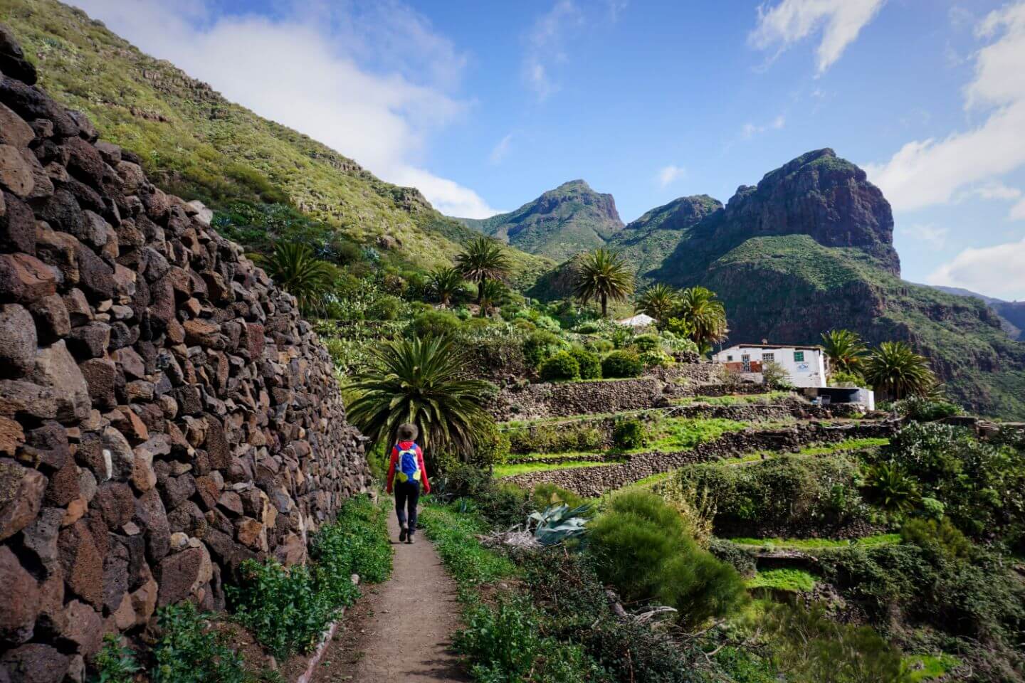
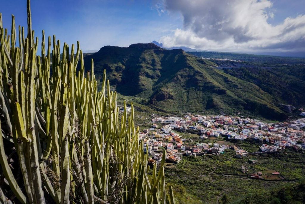
1. Santiago del Teide to Masca
Teno Mountains
Update: This trail may be closed due to construction. Please reach out to local tourist offices, or your hotel, for trail updates.
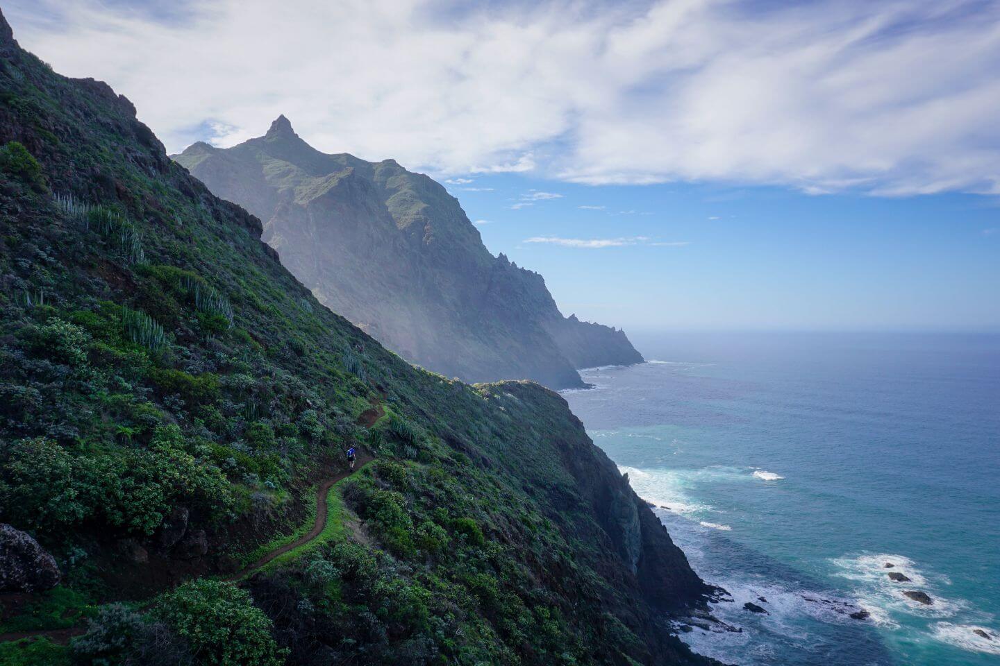
The point-to-point hike from Santiago del Teide town to Masca village showcases the majesty of the Teno Mountains.
This Tenerife hike begins with a continuous 388-meter ascent to the Degollada de la Mesa col. From the saddle, we recommend detouring to Pico Verde, which offers unbeatable views of the sinuous TF-436 road that cuts across the Teno mountains to Masca.
From Degollada de la Mesa col, follow the ridge trail. This path ultimately drops down through a laurel forest to the Mirador de Cruz de Hilda lookout point.
The last stretch takes you to Masca village, where you can grab a bite to eat before shuttling back to Masca on Bus 355.
Trail Stats
Trailhead | Santiago del Teide
Distance | 9.2 km point-to-point
Time Needed | 4 hours
Elevation Gain | 574 meters
Elevation Loss | 905 meters
Difficulty | Easy
Min. Elevation | 588 meters
Max. Elevation | 1272 meters
Route | Santiago del Teide (930 m) – Degollada de la Mesa (1247 m) – Pico Verde (1318 m) – Cruz de Hilda – Masca (620 m)
Where to Stay | Hotel La Casona del Patio (midrange) in Santiago del Teide, or Sweet Home Masca (midrange) in Masca
2. Roques de García
Teide National Park

Pico del Teide gets all the press. After all, it’s Spain’s highest mountain.
However, if you look beyond the imposing volcano, you’ll find a plethora of hiking trails that traverse Las Cañadas caldera. One short and easy walk everyone should do is Roques de García.
With Mount Teide in full view, you’ll circuit Teide National Park’s most striking rock formation in just over an hour. This short Tenerife hike starts at the Mirador de la Ruleta viewpoint, which is located directly across from Parador Nacional.
From the Mirador de la Ruleta lookout point, you’ll see the impressive La Catedral rock jutting out of the Caldera floor. In the background, the caldera rims the volcanic landscape.
Learn More: Best Hikes in Teide National Park
Trail Stats
Trailhead | Mirador de la Ruleta
Distance | 4.2 km circuit
Time Needed | 1:30 hours
Elevation Gain/Loss | 170 meters
Difficulty | Easy
Min. Elevation | 2022 meters
Max. Elevation | 2183 meters
Where to Stay | Parador de Las Cañadas del Teide (luxury) in Teide National Park, or Hotel Spa Villalba (luxury) in Vilaflor
3. Parador Nacional to Montaña Guajara Circuit Trail
Teide National Park

Montaña Guajara is the highest mountain along the caldera rim in Teide National Park.
While there are a few ways to summit Montaña Guajara, we recommend starting at Parador Nacional. From here, it’s a slow and steady ascent to the Guajara plateau. Follow the circuit trail clockwise.
At the top, you’ll have a brilliant birds-eye view of the caldera landscape and Mount Teide. The whole circuit hike takes 4:30 hours.
Trail Stats
Trailhead | Parador Nacional (bus stop, hotel, gift shop and cafeteria)
Distance | 10 km circuit
Time Needed | 4:30 hours
Elevation Gain/Loss | 647 meters
Difficulty | Moderate – Difficult
Min. Elevation | 2126 meters
Max. Elevation | 2693 meters
Route | Parador Nacional – Degollada de Guajara (mountain pass) – Guajara (mountain) – Degollada de Ucanca (mountain pass) – Parador Nacional
Where to Stay | Parador de Las Cañadas del Teide (luxury) in Teide Nationalpark, or El Tejar Hotel & Spa (midrange) in Vilaflor
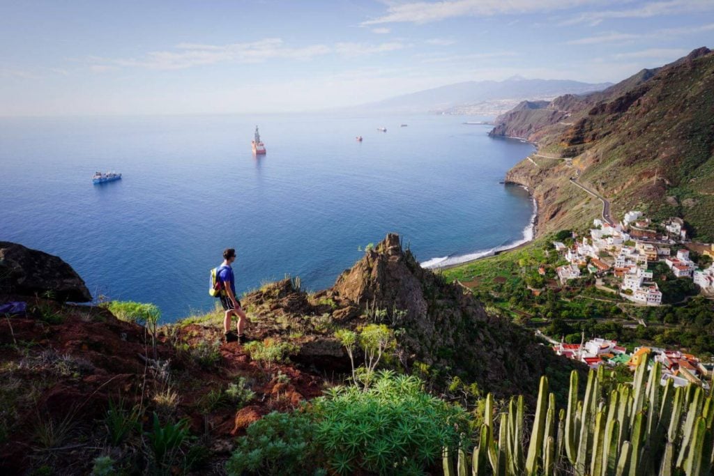
4. Benijo to Faro de Anaga Lighthouse Circuit
Anaga Mountains

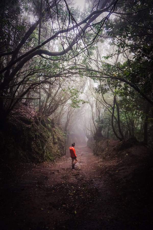
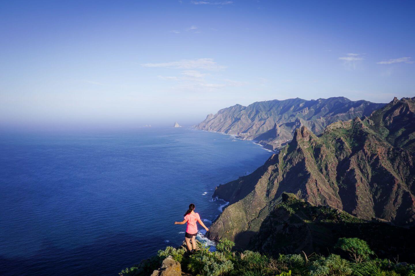
The Anaga massif is the oldest part of the island and, in our opinion, the most beautiful mountain range in Tenerife. The Anaga mountains feel like a living being, eternally gliding into the sea.
To get a substantial overview of this Tenerife mountain range, we recommend hiking this 6-hour Benijo – Chamorga circuit trail.
This Tenerife hike begins in the tiny hamlet of Benijo, close to Taganana. The trail follows the coast all the way to the Faro de Anaga lighthouse.
From the lighthouse, you’ll hike inland to the village of Chamorga, which is located at the very end of the Anaga Mountain Road. The trail then continues all the way back to Benijo.
It’s also possible to shorten this hike. When you reach El Draguillo, turn right and hike uphill in the direction of Chamorga.
After about 270 meters of elevation gain (1 km), you’ll reach an intersection. Turn right and follow this scenic trail back to Benijo.
Learn More: Benijo to Faro de Anaga trail guide
Trail Stats
Trailhead | Benijo
Distance | 14.2 km circuit
Time Needed | 7 hours
Elevation Gain/Loss | 1432 meters
Difficulty | Difficult
Minimum Elevation | 79 meters
Maximum Elevation | 640 meters
Route | Benijo (hamlet) – El Draguillo (hamlet) – Las Palmas (hamlet) – Faro Punta de Anaga (lighthouse) – Tafada (mountain) – Chamorga (village) – Benijo (hamlet)
Where to Stay | Casanaga (budget) in Almáciga, or Vivienda Vacacional Casa Taganana (luxury) in Taganana
5. Taganana to Playa de Tamadite
Anaga Mountains

This pleasant Tenerife hike from the remote village of Taganana to the beach Playa de Tamadite delivers nonstop brilliant views of the Anaga coastline in both directions.
This is an easy coastal walk with little gradient variation. The only tricky part is locating the trailhead. We used Maps.me to find it.
Early on, you’ll hike through the small wine-producing village called El Chorro. Before arriving at the Tamadite beach, you’ll descend to Barranco de Afur and cross a stream.
Playa de Tamadite is the perfect place to eat lunch and take a break, before starting the return journey back to Taganana.
Note: it’s possible to extend this hike, as seen on the map.
We weren’t able to do this circuit, because the trail between Afur and Playa de Tamadite was closed. Get updates on the trail at the Cruz del Carmen visitor center.
Learn More: Best Hikes in the Anaga Mountains
Trail Stats
Trailhead | Taganana
Distance | 10 km out-and-back
Time Needed | 4:45 hours
Elevation Gain/Loss | 767 meters
Difficulty | Moderate
Min. Elevation | 24 meters
Max. Elevation | 330 meters
Route | Taganana (village) – El Chorro (hamlet) – Playa de Tamadite (beach) – El Chorro (hamlet) – Taganana (village)
Where to Stay | Casanaga (budget) in Almáciga, or Vivienda Vacacional Casa Taganana (luxury) in Taganana
6. Punta del Hidalgo to Chinamada and Carboneras
Anaga Mountains

This Tenerife hiking trail is invariably the most popular walk in Parque Rural de Anaga. Most hikers will start at the Cruz del Carmen Visitor Center and descend all the way to Punte del Hidalgo.
That’s probably the best way to do it, especially if you’re based in La Laguna. You can take a bus to the trailhead, and then return to La Laguna with another bus from Punta del Hidalgo.
We did an out-and-back hike starting in Punta del Hidalgo to Chinamada and Carboneras because we wanted maximum flexibility. From the coast, the trail steadily climbs up above Barranco del Río to the Troglodyte (cave) settlement Chinamada.
People still live in caves here, though they are modernized. When you arrive, head to Restaurante La Cueva for heartwarming Canary food.
You can continue to Carboneras (not a must-do), or head back down to Punta del Hidalgo after lunch. For more details, read Best Hikes in the Anaga Mountains.
Trail Stats
Trailhead | Punta del Hidalgo
Distance | 15.6 km lollipop-circuit
Time Needed | 7 hours
Elevation Gain/Loss | 1577 meters
Difficulty | Difficult
Min. Elevation | 22 meters
Max. Elevation | 744 meters
Route | Punta del Hidalgo (village) – Chinamada (hamlet) – Las Carboneras (hamlet) – Chinamada (hamlet) – Punta del Hidalgo (village)
Where to Stay | Punta Paradiso (midrange) in Punta del Hidalgo, or Sunset Dream Bajamar (midrange) in Bajamar
7. Roque de Taborno Circuit Trail
Anaga Mountains
Endearingly called “Tenerife’s Matterhorn,” Roque de Taborno is a thumb-shaped rock that rises 706 meters above sea level on the north coast of the Anaga peninsula,
A short trail circuits Tenerife’s Matterhorn, delivering godly views of the Northern Anaga Coastline. DO NOT MISS THIS HIKE!
This Tenerife hiking trail begins in the hamlet of Taborno in Anaga Rural Park. When you arrive, locate the chapel. You’ll walk along the right side of the tiny church and descend a few meters to a viewpoint.
Continue following the trail to Roque de Taborno. As you circuit the rock clockwise, the views dramatically crescendo.
Trail Stats
Trailhead | Taborno
Distance | 4 km lollipop-circuit
Time Needed | 1:50 hours
Elevation Gain/Loss | 381 meters
Difficulty | Moderate
Min. Elevation | 505 meters
Max. Elevation | 635 meters
Route | Taborno (hamlet) – Mirador sobre Barranco La Fajana (lookout point) – Era de los Cardos (lookout point) – Taborno (hamlet)
Where to Stay | La Laguna Gran Hotel (midrange), or Hotel Boutique San Diego – Adults Only (luxury) in San Cristóbal de La Laguna
8. Camino del Risco – Teno Alto – Punta de Teno
Teno Mountains

To start this hike, head to the coastal town of Buenavista del Norte in the northwest of Tenerife.
Continue driving in the direction of Punta de Teno and park at the Barranco del Monte parking lot, the entrance to Carretera del Faro de Punta de Teno road.
From here, look for the Camino del Risco trail sign, indicating 3.8 km to Teno Alto.
You’ll ascend to Teno Alto (2:30 hours) along PR TF 58, a steep and thrilling trail.
Teno Alto is a remote hamlet in Parque Rural de Teno, consisting of a few scattered homesteads and lots of goats. After lunch in Teno Alto, the trail continues along the PR TF-51 to Punta de Teno.
Punta de Teno is a rocky headland that forms the northwestern tip of Tenerife. It’s crowned with a candy-cane-stripped lighthouse.
Punta de Teno is also one of the best places to admire the Los Gigantes cliffs (Acantilado de Los Gigantes).
You can return to the trailhead by bus.
Trail Stats
Trailhead | Barranco del Monte parking lot / Sendero del Risco Muertos (PR TF 58) Trailhead
Distance | 10.1 km point-to-point
Time Needed | 4 hours (Hiking only) / 6 hours total (Lunch in Teno Alto + Lighthouse + Bus)
Elevation Gain | 617 meters
Elevation Loss | 786 meters
Difficulty | Difficult
Min. Elevation | 0 meters
Max. Elevation | 782 meters
Route | Barranco del Monte – Teno Alto – Punta de Teno – Bus – Barranco del Monte
Where to Stay | Viña Camello (midrange), or Meliá Hacienda del Conde (Adults only) (luxury) in Buenavista del Norte
9. Igueste to Atalaya de los Ingleses
Anaga Mountains
The hike to Atalaya de los Ingleses delivers sensational views of the Anaga mountain range and the rugged coast. Start this hike in the morning for the best light.
Igueste de San Andrés is a small village north of Playa de las Teresitas. Huddled around Barraco de Igueste, this white-washed village is an exciting back entrance into the Anaga mountains.
When you drive to Igueste, follow the road to the other side of the Barranco (ravine). You’ll see lots of street parking along Calle Manuel Vera Álvarez, near the bus stop.
To find the trail, you’ll have to walk past a church and through a residential area. Initially, you’ll climb up a staircase and follow signs to El Semaforo on PR – TF 5. Once you’re on the trail, it’s impossible to lose it.
After steadily hiking uphill for about 300 meters (1.2 km), you’ll reach an intersection. Turn left here, following the sign to Atalaya de los Ingleses.
As you gain elevation, the village looks like a white pearl mounted on a bloodstone setting. It’s spellbinding. You’ll see Mount Teide and Santa Cruz off in the distance.
The trail eventually plateaus. You’ll ascend along a ridge to a stone shelter called Atalaya de los Ingleses. From here, it’s a quick walk to an obvious lookout point.
At the lookout, you’ll be able to see Playa de Antequera. It’s possible to extend the hike all the way down to this beach.
Trail Stats
Trailhead | Igueste de San Andrés
Distance | 5.5 km out-and-back
Time Needed | 3 hours
Elevation Gain/Loss | 691 meters
Difficulty | Moderate
Min. Elevation | 14 meters
Max. Elevation | 407 meters
Route | Igueste (village) – Atalaya de los Ingleses (abandoned stone shelter) – Viewpoint – Igueste (village)
Where to Stay | Steps to the beach (midrange) in Las Gaviotas, or San Andres Beach Apartment (midrange) in San Andres
10. Tamaimo and Montaña de Guama Circuit Trail
Teno Mountains
The circular hiking trail above Tamaimo boasts some heavenly views of the coast and the Tamaimo valley.
To find the trailhead, walk down Calle Santa Ana to the Iglesia de Santa Ana church. Next, follow Calle el Agua (a residential road) to the Barranco de Santiago stream. Follow signs for Cruz de Los Misioneros (PR TF 65.2).
From the church, it’s a 220 m ascent (1.1 km) to the Cruz de Los Misioneros viewpoint. From here, you’ll continue on the main trail to the ridgeline. The views of Santiago Valley with Pico del Teide off in the distance is well worth the effort.
The highest point of the ridge is Montaña de Guama, a small rocky outcrop marked by a white cross.
Following the ridgeline on the left side, you’ll see the rugged coastline, Barranco Seco, and La Gomera.
There’s an optional detour to the El Agujero Viewpoint (no signage). After following the ridge trail for about 500 meters, you’ll see a trail fork right. It’s a good 25 minutes to the viewpoint from this intersection.
As you descend to the viewpoint, you’ll see the coastal resort towns of Los Gigantes and Puerto de Santiago, the Gigantes Cliffs, and Barranco Seco.
The main trail descends to Degollada de Tejera. From here, the trail departs the ridge and heads down to Santiago Valley. Follow the valley trail (PR TF 65) back to Tamaimo.
The final slow ascent along the valley floor takes about 30 minutes (1.2 km).
Trail Stats
Trailhead | Tamaimo
Distance | 4.8 km circuit
Time Needed | 2:15 hours
Elevation Gain/Loss | 425 meters
Difficulty | Moderate
Min. Elevation | 438 meters
Max. Elevation | 858 meteres
Route | Tamaimo (570 m) – Cruz de los Misioneros (810 m) – Montaña de Guama (877 m) – El Agujero Viewpoint (optional) – Tamaimo
Where to Stay | Hotel La Casona del Patio (midrange) in Santiago del Teide, or Royal Sun Resort (luxury) in Los Gigantes
Keep Reading about Tenerife

Spain Trip Planning
Use our Spain Travel Guide and Spain blog archive to plan a unique and memorable trip to Spain.
When to Visit Spain
Spain is an all-year-round destination.
In summer, we recommend visiting Picos de Europa National Park in Northern Spain.
In spring and fall, we recommend traveling to Mallorca. Read April in Mallorca.
In winter, we recommend visiting the Canary Islands. Read January in Tenerife.
Getting around Spain
We always rent a car when traveling in Spain. Use these road trip itineraries for trip planning inspiration:
- Picos de Europa, Northern Spain Road Trip
- Mallorca Road Trip
- Tenerife Road Trip
- Gran Canaria Road Trip
Car Rental
We recommend using the Discovercars.com car rental reservation platform to search for and book car rentals in Spain. This easy-to-use booking platform compares car rental deals from 500+ trusted providers, so that you can choose the best option for your trip.
Hiking in Spain
We love hiking in Spain, because of the country’s varied alpine, coastal, and volcanic landscapes. Read these region-specific hiking guides:
- Picos de Europa Hikes
- Mallorca Hikes
- Gran Canaria Hikes
- Tenerife Hikes
What to See & Do in Spain
- Stay in a Finca on Mallorca like Mirabó de Valldemossa is Valldemossa, Finca Ca’s Curial – Agroturismo – Adults Only in Soller, or Son Brull Hotel & Spa in Pollenca.
- Hike the Ruta del Cares gorge trail in the Picos de Europa mountains.
- Hike around the highest mountain in Spain, Mount Teide, in Teide National Park in Tenerife.
- Hike in the dazzling, prehistoric-looking Anaga Rural Park in Northern Tenerife.
- Hike to Güi Güi Beach, the most pristine beach in Gran Canaria.
- Visit the charming town of Potes in Cantabria, Northern Spain.
- Visit the Sanctuary of Covadonga and Lakes of Covadonga in Asturias, Northern Spain.
Pin this Image for Future Trip Planning!
Stay Connected:
Connect with us on Pinterest.
Follow us on Instagram.
Like us on Facebook.
Support Us:
If you love reading our content, you can buy us a coffee via Ko-Fi. Many thanks!

Hi! Santiago del Teide to Masca track is partially closed due to highway construction. Going out of Santiago el Teide there is no official way to reach the ascend by the stream. Way up is blocked by constructions site, when going up to summit (first junction of paths meetings) you would see a sign that path down is closed. The ascend is moderate, other parts are easy yes.
Thank you SO much for this info, I used this post a lot on a family holiday and we had the best time ! We enjoyed the taganana coastal walk and the roque de Garcia loop so so much. Highly recommend !
Hi Roisin,
So happy to hear you had a great time hiking in Tenerife.
Best wishes,
Sabrina