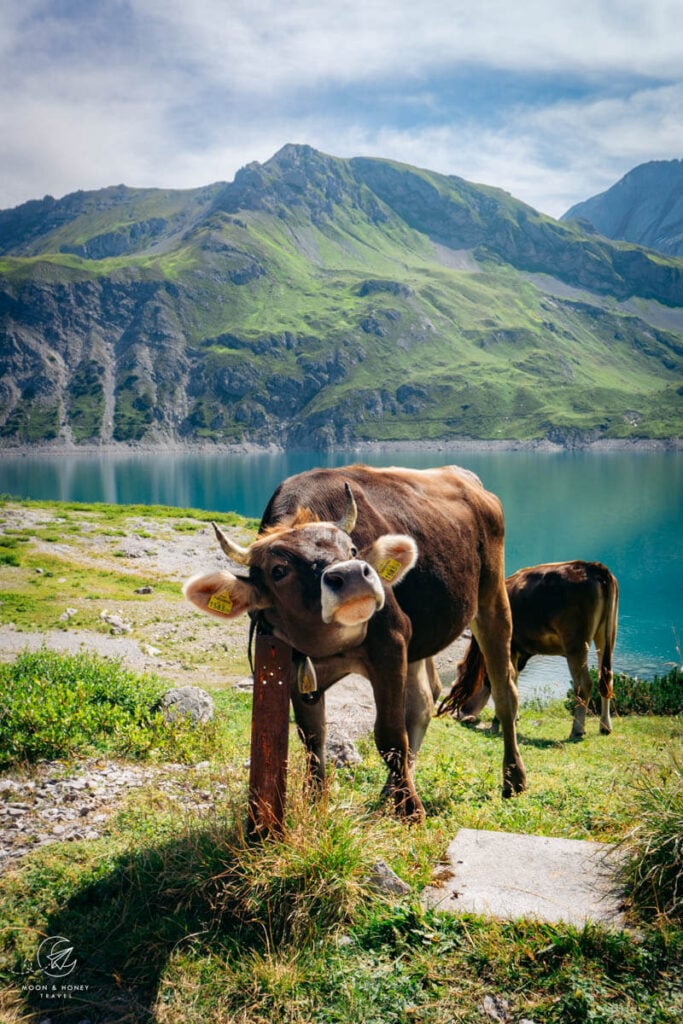
Lünersee is a large alpine lake high above Brandnertal in the Austrian State of Vorarlberg. Set amidst the striking limestone mountains of the Rätikon Alps, this gorgeous lake is a destination like no other.
Lünersee Lake is highly accessible, as there’s an aerial cableway that connects Brandnertal (Brandner Valley) to the lake. Not surprisingly, this is a very popular alpine destination for families and people of all ages.
We recommend carving out at least half-a-day to hike around the lake, eat lunch at Douglashütte, and even summit the highest peak in the Rätikon Alps.
We visited Lünersee in order to start this 4-day hut to hut hike, which was one of the best treks we’ve ever done in the Alps.

- Area: 112 hectares / 1.12 square km
- Depth: 139 meters
- Surface Elevation: 1,970 meters
- Swimming: Not permitted.
- Fishing: Allowed with Fishing Club Day Pass. Fishing is allowed from the middle of June until late October.
- Boating: No boats are allowed on Lünersee.
- Camping: Camping is forbidden. If you want to stay the night at Lünersee, you can overnight in Douglashütte mountain hut.
- Cycling: Not permitted.
- Drones: Only permitted with authorization.
- Dogs: Allowed, also in the cable car.
- Public Transit Accessible: Yes.
- Where to Eat: Douglasshütte, Lünersee Alpe
- Must-Do Day Hike: Lünersee Circuit Trail, Schesaplana Summit
- Must Do Trek: Rätikon Alps High Trail
- Recommended Itinerary: 14-Day Austria Itinerary
- Where to Stay in Brand: Pension Bergkristall (budget), Hotel Lün (midrange), or Aktiv-Hotel Sarotla (luxury)
- Recommended Trail Map: WK 5374 Brandnertal – Rätikon
Lake Lünersee Hiking Map
How to Get to Lünersee

Car
If you’re driving, you can drive through Brandnertal all the way to the parking lot at the Lünerseebahn cablecar.
Parking fee | 4 EUR / day
Payment | EUR Coin, or card payment possible
Public Transit
The easiest way to get to Lünersee is from Brandnertal. It’s easy to reach Brandnertal by public transit from Austria’s major cities.
From Innsbruck, Linz, Salzburg, or Vienna, take a direct train to Bludenz.
From Bludenz, take bus #580 to Brandnertal (direction: Lünersee). The bus station in Bludenz is located directly outside the train station.
You purchase your bus tickets in the bus.
Travel time (Bludenz – Brand in Vlbg Lünerseebahn Talstation): 41 min.
Book your Train Ticket to Bludenz.
Riding the Lünerseebahn

Lünerseebahn is an aerial cableway to Lüner Lake, high above Brandner Valley. You can walk from the base of the cableway station to the lake, but we suggest taking the Lünerseebahn.
Opening Times | Current Opening Times
Operating Hours | ascent: every 15 min between 8:00 am and 16:55 pm; descent: every 15 min between 8:10 am and 17:00 pm
Prices | Current Pricing
Where to Eat around Lünersee

Douglass Hütte
Douglass mountain hut (1979 m) is located next to the Lünerseebahn top station. They have ample outdoor seating along the lake as well as comfortable indoor seating.
The food is excellent. And, the service is even better. We loved their Bauernsalat (Farmer’s Salad).
Lünersee Alpe
The Alpe Lünersee is a traditional “Alpe” (aka alm) mountain hut, located on the opposite side of the lake from Douglass Hütte.
You can try their fresh Buttermilch (buttermilk), which is a traditional dairy drink in the Austrian Alps. They also serve sausage, cake, and a few other snacks.
Totalphütte
Totalp mountain hut (2385 m) is located on the trail to Schesaplana peak, a good 400-meter ascent from the lake.
We stopped here for an Apfel Strudel and coffee – both of which were outstanding.
Lünersee Day Hikes
Lünersee Circuit Trail

The Lünersee circuit trail wraps around the entire lake. This is an easy trail suitable for everyone. From the cableway top station, you can walk in either direction.
If you go right first, the trail is initially flat. If you go left first, you’ll pass Douglasshütte (1979 m), cross the reservoir wall, and then initially ascend several meters, before the trail levels.
Trail Stats Lünersee Circuit Trail
Trailhead | Lünerseebahn mountain station
Distance | 6 km circuit
Time Needed | 1:45 hours
Elevation Gain/Loss | 105 meters
Difficulty | Easy
Minimum Elevation | 1967 meters
Maximum Elevation | 2071 meters
Lünersee Circuit Trail and Gafalljoch ridge (2239 m)

This hike follows the circuit path to Lünersee Alpe, which is the alm mountain hut located directly across the lake from the cableway top station. From here, you’ll hike to Gafalljoch ridge.
The Gafalljoch ridge forms part of the Austrian – Swiss border, so you can step foot into Switzerland.
After enjoying the view from Gafalljoch (2239 m), head back down to the lake and complete the loop.
Trail Stats Lünersee Circuit Trail and Gafalljoch ridge
Trailhead | Lünerseebahn mountain station
Distance | 8.6 km lollipop circuit
Time Needed | 3 hours
Elevation Gain/Loss | 364 meters
Difficulty | Moderate
Minimum Elevation | 1967 meters
Maximum Elevation | 2239 meters
Totalphütte (2385 m)

After exiting the cableway station, make a right. Follow the circuit trail around Lünersee until you see a sign to Totalphütte (2385 m).
It’s a 400 m ascent to the hut. You’ll need sturdy hiking shoes.
Hike up here for delicious food and great views of the lake. After enjoying the hut, hike back down to the lake.
Trail Stats Totalphütte
Trailhead | Lünerseebahn mountain station
Distance | 6.7 km out-and-back
Time Needed | 2:45 hours
Elevation Gain/Loss | 418 meters
Difficulty | Moderate
Minimum Elevation | 1972 meters
Maximum Elevation | 2383 meters
Read Next: Best Day Hikes in Austria
Schesaplana Summit (2964 m)

This difficult hike to the highest mountain in the Rätikon takes 3 hours.
After passing Totalphütte (2385 m), you’ll continue ascending to the summit (2964 m).
Wear sturdy hiking shoes and bring your hiking poles with you. The path is clearly marked and easy to follow. Expect lots of scree.
Trail Stats Schesaplana
Trailhead | Lünerseebahn mountain station
Distance | 13.4 km out-and-back
Time Needed | 5:30 hours
Elevation Gain/Loss | 1095 meters
Difficulty | Moderately difficult
Minimum Elevation | 1967 meters
Maximum Elevation | 2965 meters
Lünersee Multi-Day Hikes
Lünersee 4-Day Hut to Hut Hiking Route

We hiked 4 days around the Rätikon mountains, starting and ending at Lünersee. We wrote this detailed Rätikon hiking itinerary, so you can experience this amazing route too.
Here’s the route summary:
Day 1 | (Brandnertal) – Lünersee – Lindauer Hütte (4 hours, 10 km)
Day 2 | Lindauer Hütte – Tilisunahütte – Carschinahütte (5 hours, 10.2 km)
Day 3 | Carschinahütte – Schesaplanahütte (6 hours, 15.8 km)
Day 4 | Schesaplanahütte – Schesaplana – Totalphütte – Lünersee – (Brandnertal) (9.2 km, 5 hours)
If you’re new to hut to hut hiking, read our Hut to Hut Hiking in Austria Guide.
Lünersee 3-Day Hut to Hut Hiking Route

This is a perfect 3-day route suitable for families and anyone who wants an easy, but tremendously beautiful hike.
If you’re new to hut to hut hiking, this is a great place to start. You can follow the same itinerary. However, on Day 3, you’ll descend down to Lünersee from Gafalljoch/Cavelljoch.
Day 1 | (Brandnertal) – Lünersee – Lindauer Hütte (4 hours, 10 km)
Day 2 | Lindauer Hütte – Tilisunahütte – Carschinahütte (5 hours, 10.2 km)
Day 3 | Carschinahütte – Gafalljoch/Cavelljoch – Lünersee – (Brandnertal) (5 hours, 13.6 km)
Where to Stay near Lünersee

The best base for exploring Lünersee is in the town of Brand in Brandnertal.
Midrange | Pension Bergkristall is an apartment-style accommodation in Brand, next to the Dorfbahn Cable Car Station. If you’re planning to base yourself in Brandnertal for a few days, or even a week, you’ll feel very comfortable here. Breakfast is available upon request.
Midrange | Hotel Lün is a top-rated modern alpine hotel in Brand, offering double rooms as well as apartments with fully equipped kitchenettes and dining areas. Highlights of staying here are the spa area, the breakfast buffet, the fresh and cheerful design.
Luxury | Aktiv-Hotel Sarotla is a stylish and modern hotel with excellent spa facilities, spacious rooms with balconies, and a fabulous hotel restaurant and bar. Guests can participate in guided hiking and cycling tours free of charge.
Look for accommodation in Brandnertal.
Austria Trip Planning Essentials
Use our Austria Travel Guide and Austria blog archive to plan a unique and memorable trip to Austria.
When to Visit Austria
Summer and early Fall are our favorite seasons in Austria.
Getting around Austria
Austria has an excellent public transit system. We’ve used it extensively to travel throughout the country. We highly recommend using transit if you’re visiting cities (Vienna, Salzburg, Innsbruck, Graz, etc…), and/or doing hut-to-hut hikes.
Some areas like Mayrhofen, Schladming and Lech am Arlberg have wonderful seasonal transit systems in place (e.g. summer hiking buses). However, if you’re not visiting during the high season, bus frequencies are significantly reduced and it’s far easier to get around with your own vehicle.
If you’re planning on visiting multiple destinations across Austria, we recommend renting a car.
Use these road trip itineraries for trip planning inspiration:
- 2 Week Austria Road Trip – starting in Vienna
- 1 Week Austria Road Trip – starting in Salzburg or Munich
- 10-Day Bavarian Alps & Tyrolean Alps Road Trip – starting in Munich
Car Rental
We recommend using the Discovercars.com car rental reservation platform to search for and book car rentals. This easy-to-use booking platform compares car rental deals from 500+ trusted providers, so that you can choose the best option for your trip.
If you’re driving into Austria from a neighboring country, don’t forget to purchase a vignette at/near the border.
Hiking in Austria
Where to Hike in Austria
Read Austrian Alps Hiking Destinations for an overview of where to hike in Austria, with tips on specific trails and where to stay. Also check out Best Day Hikes in Austria and these region-specific hiking guides:
- Salzburg Hiking Guide
- Filzmoos, Salzburg Hiking Guide
- Schladming, Styria Hiking Guide
- Lech am Arlberg, Vorarlberg Hiking Guide
- Vorarlberg Hiking Guide
- Vienna Mountains Hiking Guide
Hut to Hut Hiking in Austria
Austria is a premier hut-to-hut and long-distance hiking destination. The quality of the mountain huts are superb. We particularly love the high-alpine trails, which are called Höhenwege in German. We’ve summarized our favorite multi-day hikes in Trekking Austria. If you’re new to hut hiking, read this in-depth guide to Hut to Hut Hiking in Austria.
Hiking Essentials
- Trekking Pack: Osprey Kyte 36 – women / Osprey Kestrel 38 -men
- Day Pack: Osprey Tempest 30 Women’s Backpack / Osprey Talon 33 Men’s Backpack
- Grade B/C high-cut hiking boots: Meindl Schuhe Island Lady (Kati’s Boots), Women’s Hanwag Tatra II GTX (Sabrina’s Boots), Men’s Hanwag Tatra II GTX (men’s equivalent)
- CAT 4 Sunglasses: Julbo Shield Mountain Sunglasses
- Hiking Poles: Black Diamond Trail Trekking Poles
- Backpack Camera Clip: Peak Design Camera Clip
What to See & Do in Austria
- Visit a gorge like the Liechtenstein Gorge in Salzburg.
- Bathe in the thermal pools of an Austrian Therme like Aqua Dome in Tirol
- Stay in a thermal spa hotel like Rogner Bad Blumau in Styria, EurothermenResort Bad Ischl in Upper Austria, or the Aqua Dome Hotel in Tirol.
- Hike to a mountain lake like Lake Tappenkarsee in Salzburg or Lake Drachensee in Tirol.
- Go Wine Tasting in South Styria.
- Marvel at the culture, music, and architecture of Vienna.
- Eat heartwarming mountain food in an Almhütte at Grosser Ahornboden in Tirol or Ursprungalm in Styria.
- Drive the Grossglockner High Alpine Road in Hohe Tauern National Park.
- Visit the castles, monasteries, and wine taverns of the Wachau Valley, a UNESCO World Heritage Site.
Austrian Hotels
- Best Hotels in the Austrian Alps
- Best Hotels in Lech am Arlberg, Vorarlberg
- Wellness Hotel Theresa, Zillertal, Tirol
- Hotel Eder in Maria Alm, Salzburg
Learn more about the European Alps:


