Rötelstein (2247 m), also called Rettenstein, is a mountain northeast of Filzmoos in Salzburg, Austria.
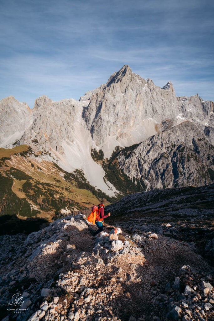
Overshadowed by the awe-inspiring Dachstein massif, Rötelstein doesn’t command as much immediate attention. However, its summit affords one of the most spectacular vistas of the Gosaustein and Dachsteinsüdwand (Dachstien south face). Views also extend to other Northern Limestone Alps groups as well as the Grossglockner and Venediger ranges.
The Rötelstein summit hike is exciting and demanding. Hikers must be comfortable scrambling and tackling broken rock and scree terrain.
We love this hike in Salzburg because of the interesting ridge ascent and unbelievable peak views.
After conquering the summit, treat yourself to a heartwarming meal at Sulzenalm (Wallehenhütte or Krahlehenhütte) before completing the circuit.

- Trailhead: Rettensteinhütte Car Park, Filzmoos | Google Maps
- Distance: 9.8 km circuit
- Time Needed: 5 hours
- Difficulty: Difficult
- Elevation Gain/Loss: 937 meters
- Minimum Elevation: 1309 meters
- Maximum Elevation: 2246 meters
- Route: Rettensteinhütte – Ahorneggalm – Rötelstein – Sulzenhals – Sulzenalm – Rettensteinhütte
- When to Hike: June – October, depending on weather/snow conditions.
- Where to Stay in Filzmoos: Bauernhof Krahlehenhof (midrange), Das Anja Alt Filzmoos (midrange), or meiZeit Lodge (luxury)
- Recommended Trail Map: Dachstein WK 0281 1:50000 (Freytag & Berndt)
Rötelstein Hiking Trail Map
Rötelstein Trail Difficulty

The Rötelstein peak hike isn’t very long (only 9.8 km), but it has some technically demanding sections. Hikers must tackle a few easy scrambling passages on the ascent (trail 670), some of which are a bit airy.
The descent along trail 639 to Sulzenhals saddle is steep and difficult. Much of the path is characterized by broken rock and scree. It’s slippery at times. Surefootedness and high-alpine hiking experience are a must.
Rettensteinhütte to Rötelstein Peak Trail Description
Rettensteinhütte – Ahorneggalm – Rötelstein (2:40 hours)

The hike begins at the Rettensteinhütte (only open in winter). There’s a free car park at the hut.
From Jausenstation Rettensteinhütte, trail 670 leads to a wide-open pasture area/slope. Ascend the slope for a few minutes, until a trail sign directs you left onto a level grassy trail. Follow this wide path through a patch of forest.
After passing through a pasture gate, the trail ascends through larch and spruce and across meadows towards Rötelstein.
After a hefty ascent, the gradient eases and the trail leads west across the mountain pasture of Ahorneggalm.
The Dachstein’s mighty neighbors, Hochkönig and the Tennen Mountains, are visible straight ahead. When the trail turns north, Bischofsmütze and the Gosaukamm range come into view.

The trail squeezes through dwarf pine to reach the red rocky southwest slope of Rötelstein.
The path crosses to the right side of the crest and twists up dwarf pine.

For the next hour, the trail follows the crest (either directly on, or beneath), alternating between easy scrambling and walking passages.
Always follow the red-white-red painted waymarks.

The final stretch to the summit unravels gloriously towards the massive gray limestone walls of Torstein (2948 m), Mitterspitz (2925 m), and Hoher Dachstein (2995 m).
The grassy summit is marked with a cross.
Rötelstein to Sulzenhals (50 minutes)

Continue north across the wide ridge plateau.
The friendly grassy trail turns to loose rocks as the path drops steeply down the northeast side of the mountain.

Follow the waymarks through scrambling passages and across broken rock and scree.
The trail gets significantly easier as you approach the Sulzenhals saddle.
Sulzenhals to Sulzenalm (30 minutes)

The Sulzenhals saddle is on the ridge that divides the Bachlalm valley from the Hinterwinkle valley above Filzmoos.
Turn left in the direction of Sulzenalm, signed 30 minutes.
The path descends through dwarf pine and later larches to reach the pasture area of Sulzenalm, home to two managed alpine pasture huts.

Wallehenhütte (the higher hut) and Krahlehenhütte (the lower hut) are both welcoming and idyllically situated. You simply have to eat a Kaiserschmarrn at either hut.
If weather conditions permit, these huts will stay open until the end of October.
Sulzenalm to Rettensteinhütte (1 hour)

Follow the road to the trail intersection across from Krahlehenhütte.
Turn left in the direction of Reithof.
The path wraps around the pasture area of Mandlinghofalm, backed by the iconic Bischofsmütze.
The way to Rettensteinhütte passes easily through forest and meadows. The final leg follows a forest road and ultimately a paved road back to the starting point.
Where to Stay in Filzmoos
Midrange | Bauernhof Krahlehenhof is a traditional farm with double rooms, family rooms, and apartments. Set in an idyllic location, this lovely accommodation offers a wonderful breakfast, a welcoming and authentic atmosphere, and cozy interiors. We ate a delicious dinner here during our last visit to Filzmoos.
Midrange | Das Anja Alt Filzmoos offers rooms and apartments in the heart of Filzmoos. Stay here for the intimate setting, excellent location, and lovely rooms. Guests receive the Filzmoos Sommer Card.
Top Choice – Luxury | meiZeit Lodge is a tastefully-furnished boutique hotel in the town center of Filzmoos. Stay here for the generous breakfast buffet (included in rate) and relaxing wellness facilities (Finnish pine sauna, bio herbal sauna, infrared relaxation loungers, relaxation zone, and vital drink bar). This charming accommodation also serves a complimentary afternoon cake selection between 3:00 and 5:00 pm.
Luxury | Hotel Neubergerhof is located on a plateau in the Ski Amadé Ski Area, 6 km from the town center (10-minute drive). The room rate includes breakfast & dinner (half board). Stay here for the quiet surroundings, mountain surroundings, rich breakfast buffet and outstanding multi-course dinner, and friendly staff. Guests have access to an indoor swimming pool, family sauna, and adults-only wellness area (Finnish sauna, bio sauna, steam bath, relaxation room).
More accommodations in Filzmoos: Haus Ratgeb (budget), B&B Landhaus Vierthaler (midrange)
Look for accommodation in Filzmoos.
Filzmoos Hiking Guides
Trails:
- Filzmoos, Salzburg: Summer & Fall Guide
- Bachlalm to Neustadtalm Circuit Hike
- Hofpürgl Hut to Sulzenalm Circuit Hike
Austria Trip Planning Essentials
Use our Austria Travel Guide and Austria blog archive to plan a unique and memorable trip to Austria.
When to Visit Austria
Summer and early Fall are our favorite seasons in Austria.
Getting around Austria
Austria has an excellent public transit system. We’ve used it extensively to travel throughout the country. We highly recommend using transit if you’re visiting cities (Vienna, Salzburg, Innsbruck, Graz, etc…), and/or doing hut-to-hut hikes.
Some areas like Mayrhofen, Schladming and Lech am Arlberg have wonderful seasonal transit systems in place (e.g. summer hiking buses). However, if you’re not visiting during the high season, bus frequencies are significantly reduced and it’s far easier to get around with your own vehicle.
If you’re planning on visiting multiple destinations across Austria, we recommend renting a car.
Use these road trip itineraries for trip planning inspiration:
- 2 Week Austria Road Trip – starting in Vienna
- 1 Week Austria Road Trip – starting in Salzburg or Munich
- 10-Day Bavarian Alps & Tyrolean Alps Road Trip – starting in Munich
Car Rental
We recommend using the Discovercars.com car rental reservation platform to search for and book car rentals. This easy-to-use booking platform compares car rental deals from 500+ trusted providers, so that you can choose the best option for your trip.
If you’re driving into Austria from a neighboring country, don’t forget to purchase a vignette at/near the border.
Hiking in Austria
Where to Hike in Austria
Read Austrian Alps Hiking Destinations for an overview of where to hike in Austria, with tips on specific trails and where to stay. Also check out Best Day Hikes in Austria and these region-specific hiking guides:
- Salzburg Hiking Guide
- Schladming, Styria Hiking Guide
- Lech am Arlberg, Vorarlberg Hiking Guide
- Vorarlberg Hiking Guide
- Vienna Mountains Hiking Guide
Hut to Hut Hiking in Austria
Austria is a premier hut-to-hut and long-distance hiking destination. The quality of the mountain huts are superb. We particularly love the high-alpine trails, which are called Höhenwege in German. We’ve summarized our favorite multi-day hikes in Trekking Austria. If you’re new to hut hiking, read this in-depth guide to Hut to Hut Hiking in Austria.
Hiking Essentials
- Day Pack: Osprey Tempest 30 Women’s Backpack / Osprey Talon 33 Men’s Backpack
- Grade B/C high-cut hiking boots: Meindl Schuhe Island Lady (Kati’s Boots), Women’s Hanwag Tatra II GTX (Sabrina’s Boots), Men’s Hanwag Tatra II GTX (men’s equivalent)
- CAT 4 Sunglasses: Julbo Shield Mountain Sunglasses
- Hiking Poles: Black Diamond Trail Trekking Poles
- Backpack Camera Clip: Peak Design Camera Clip
What to See & Do in Austria
- Visit a gorge like the Liechtenstein Gorge in Salzburg.
- Bathe in thermal pools of an Austrian Therme like Aqua Dome in Tirol.
- Stay in a thermal spa hotel like Rogner Bad Blumau (designed by Friedensreich Hundertwasser) in Styria, EurothermenResort Bad Ischl in Upper Austria, or Aqua Dome Hotel in Tirol.
- Hike to a mountain lake like Lake Drachensee in Tirol or Lake Tappenkarsee Hike in Salzburg.
- Go Wine Tasting in South Styria.
- Marvel at the culture, music, and architecture of Vienna.
- Eat heartwarming mountain food in an Almhütte at Grosser Ahornboden in Tirol or Ursprungalm in Styria.
- Drive the Grossglockner High Alpine Road in Hohe Tauern National Park.
- Visit the castles, monasteries, and wine taverns of the Wachau Valley, a UNESCO World Heritage Site.


