Triglav National Park is the largest protected area in Slovenia and covers an area of 838 square kilometers. This alpine wonderland encompasses a huge chunk of the Julian Alps (Julijske Alpe), which is part of the Southern Limestone Alps. The park’s name is derived from the highest mountain in Slovenia, Mount Triglav (2864 m).
We hiked four days hut to hut across Triglav National Park, starting at Vršič Pass (close to Kranjska Gora) and ending at Lake Bohinj.
Because this is a point-to-point hike, we used public transit to get to the trailhead.
We designed this custom hiking route across Triglav National Park to see the highlights of the Northern Julian Alps, including the high alpine plateau of Kriških podih, Mount Triglav, the Seven Lakes Valley, Luknja pass, and the fairy tale pasture around Planini pri Jezeru.
This Slovenian hut-to-hut hike was sensational. It rewarded us with enchanting views of mountains, edelweiss, ibex, and alpine lakes.
4-Day Triglav National Park Traverse
Stage 1 | Vršič Pass – Pogačnikov dom na Kriških podih (9 km, 6:30 hours)
Stage 2 | Pogačnikov dom na Kriških podih – Koča na Doliču (9.4 km, 6 hours)
Stage 3 | Koča na Doliču – Koča pri Triglavskih jezerih (9.1 km, 5 hours)
Stage 4 | Koča pri Triglavskih jezerih – Lake Bohinj (16 km, 6 hours)
Day Hiking | If you are interested in exploring Triglav National Park but don’t have the time, or inclination, to go on a hut-to-hut hike, read our Triglav National Park Travel Guide and Julian Alps Hiking Guide. Recommended guidebook: Cicerone Julian Alps hiking guide.
Possible Trail Closures
We wrote this Triglav National Park Traverse trekking guide based on our personal experience. Keep in mind that things can change over time: trail difficulty, accessibility, routing (due to rock falls, landslides, and avalanches) and hut management (reservation system, hospitality, payment, food quality, etc…).
We encourage you to reach out to the mountain huts for updates on trail conditions in advance of your trip. The stanje-poti website is one resource to find out if trails are closed. However, in our experience, this website isn’t always updated on a timely basis.
Responsible Hiking in Triglav National Park
Triglav National Park is a treasure and it’s a luxury to be able to visit. Please read these rules and follow them during your visit.
- Respect the habitats of animals and plants. Picking flowers is not allowed.
- Camping outside designated areas is not permitted. Wild camping is forbidden.
- Take all garbage back with you down to the valley. Leave no trace.
- Trails are allowed only for hiking, not for mountain biking.
- Bathing in mountain lakes is strictly prohibited.
- When to Hike: July, August, or September
- Where to Stay: Mountain Huts only. Wild camping is strictly prohibited in Triglav National Park.
- How to Book the Triglav National Park Traverse: Independently, or book this self-guided Crossing the Julian Alps Trek with Slotrips.
- Overnight Hut Discounts: Discounts are administered to guests with Alpine Club ID cards on which the logo of the reciprocal rights agreement is printed. Learn more about alpine club membership in Tips for Hiking in the Alps.
- What to Pack: Cash, passport, sleeping bag liner (e.g. Sea to Summit liner). Read our Hut to Hut Hiking Packing List.
- Trail Map: Julische Alpen: 1:50K Hiking Map WK141 or Triglav National Park WK5141
- Tips for Hut Hiking in Slovenia: Read Hut-to-Hut Hiking in Slovenia and Slovenia Mountain Huts.
- Where to Stay Before the Trek: Pri Marusi (budget), B&B Brezov Gaj (budget), Hotel Vandot (midrange) in Kranjska Gora
- Where to Stay After the Trek: Apartments Cerkovnik (budget), Pr `Agotnik apartmaji sobe Bohinj (midrange), Hotel Majerca (luxury), or Hotel Bohinj (luxury) around Lake Bohinj
Triglav National Park Traverse Hiking Map
Triglav National Park is located in north-western Slovenia. The park territory corresponds with the Eastern Julian Alps and neighbors north-eastern Italy.
The park is accessible from Kranjska Gora, Trenta, Soča, Bovec, Ukanc, Stara Fužina, and many other towns. The highest peak in the park is Mount Triglav, 2864 m.
TRIGLAV TRAVERSE STAGES
Where to Stay
Stage 1
Stage 2
Stage 3
Stage 4
National Park Boundary
Optional Routes
Triglav National Park Trek Difficulty
This Triglav hut-to-hut hike is not suitable for beginners, or hikers without alpine experience.
This is a challenging hut-to-hut hike, but manageable if you have high-alpine hiking experience, specifically in limestone and karst environments. This hike requires scrambling and hiking along secured passages with fixed cables and pegs.
If you’re considering this route, you should be surefooted, agile, and very confident hiking in scree (loose rocks).
Some of our readers have informed us that this trek was the hardest multi-day hike that they have ever trekked. Other readers said that it was very difficult because of the uneven limestone terrain and scrambling.
The difficulty of this trek will really depend on your experience.
While a full via ferrata kit isn’t necessary to tackle the secured passages along this Triglav Trek, a climbing helmet is essential for your safety.
Women’s Climbing Helmet: Black Diamond women’s climbing helmet
Men’s Climbing Helmet: Black Diamond men’s climbing helmet
All trails in Slovenia are marked with the Knafelc Waymark, which is a red circle with a white center. Trail markings are generally well-maintained and easy to follow.

How to Book the Triglav Trek and Mount Triglav Summit
You can book this trek independently. However, there are many advantages to booking this trek with Slotrips, our favorite hiking tour operator in Slovenia.
Their self-guided Crossing the Julian Alps hiking tour follows the same route, but starts in Planica near Kranjska Gora, thus adding one day to the trek.
They book all your mountain hut overnights as well as your hotel accommodations in Ljubljana (before the trek) and in Bled (after the trek).
On day 2, you will be transferred from Ljubljana to the trailhead, which is far smoother than navigating with transit. Your extra luggage will be transferred to Bled, so you don’t have to worry about storing your extra baggage while you’re trekking across the Julian Alps.
Additional benefits include a hiking app with GPS tracks for easy navigation and 24 hour support.
And perhaps the most compelling reason to book this self-guided tour is that you have the option to add on Mount Triglav summit with a IFMGA licensed mountain guide. Your guide will also bring you all necessary via ferrata equipment, so you neither have to rent, nor carry the extra equipment with you.
If you’re interested in a fully-guided hike, Slotrips can create a custom trek for you as well.
For more information about overnight pricing, typical hut food, and amenities, read our guide to Slovenian mountain huts. Read hut to hut hiking in Slovenia to learn about when to trek in Slovenia, how to plan a hut to hut hike, trail signage and waymarking, and more.
Arrival Day | Stay in Kranjka Gora at Pri Marusi (budget), B&B Brezov Gaj (budget), Hotel Vandot (midrange), or Garni Hotel Miklič (midrange), or Hotel Pino Alpino (midrange-luxury).
Stage 1 | Pogačnikov dom na Kriških podih – Online Reservation via Alpsonline
Stage 2 | Koča na Doliču – Online Reservation via Alpsonline
Stage 3 | Koča pri Triglavskih jezerih – Online Reservation via Alpsonline
Stage 4 | The trek ends at Lake Bohinj. We recommend staying at least one night in Stara Fužina, or Ribčev Laz: Apartments and rooms Cerkovnik (budget), Pr `Agotnik apartmaji sobe Bohinj (midrange), Hotel Majerca (luxury), or Hotel Bohinj (luxury).

Arrival Day in Kranjska Gora
We recommend spending at least one night in Kranjska Gora to acclimate. This ski resort town is a lovely destination in its own right.
Where to Stay in Kranjska Gora
Budget | Pri Marusi is a centrally-located guesthouse in Kranjska Gora with exceedingly kind and attentive owners. Rooms are modern and immaculate. Breakfast is included.
Midrange | Hotel Vandot is a cozy and comfortable hotel in the center of town. Breakfast is included.
Midrange | Garni Hotel Miklič is a traditional, family-run accommodation with spotless rooms and raving reviews. Guests love the welcoming hosts, central location, and superb breakfast.
More budget options | Vitranc Apartments, Gostilna Pri Martinu, and B&B Brezov Gaj.
More midrange options | Apartma Peček Kranjska Gora, Hotel Pino Alpino, and Vila Mojca – Apartmaji Lena
Look for accommodation in Kranjska Gora.
Where to Stay at Vršič Pass
Budget | Erjavčeva koča is a rustic mountain hut located directly at Vršič Pass. They offer a selection of private and dormitory rooms. It makes sense to stay here, because you’re perfectly positioned for tackling stage 1 of the trek.
Look for accommodation at Vršič Pass.

Triglav National Park Traverse Stage 1: Vršič Pass – Pogačnikov dom na Kriških podih
Stage 1 of this Triglav Trek follows the Slovenian Mountain Trail (marked with the number 1). There are several ways to reach today’s destination, Kriških podih.
We opted for the easiest route, which circumvents Mount Prisank. If you’re a confident alpine hiker with lots of via ferrata experience, you could hike up and over Prisank on your way to sedlo Planja. We recommend consulting a hiking map to see what your options are.
Stage 1 Trail Stats
Distance | 9 km
Time Needed | 6:30 hours
Elevation Gain | 1269 meters
Elevation Loss | 855 meters
Difficulty | Difficult
Minimum Elevation | 1607 meters
Maximum Elevation | 2424 meters
Route | Vršič Pass (1611 m) – Pagan Girl Lookout Point – Na robu – Zadnje Plate – Sedlo Planja (2349) – Pogačnikov dom na Kriških podih (2050 m)
Lunch Option | None
How to Get to the Vršič Pass Trailhead
There’s a bus that departs several times a day from Kranjska Gora to Vršič Pass. The same bus continues to Trenta and Soča Valley.
Use the Nomago.si website to find out what the bus schedule is in advance. Timetables are usually published on the Kranjska Gora website as well. You can also just check the timetable, which is posted at the Kranjska Gora bus stop.
The road to Vršič Pass is known as the Russian Road (Ruska cesta) because it was built by Russian prisoners of war during the First World War.
Vršič Pass – Sedlo Planja – Pogačnikov dom na Kriških podih
From Vršič Pass, head to the Pagan Girl Rock lookout point, marked by an info-board.
At the Pagan Girl Rock lookout, you’ll find the turn-off to Prisank.
After passing through dwarf pine, the first segment of the trail is initially very rocky.
At Na Robu, the trail forks. You should head down and right.
The trail follows the forest line for a long time. Eventually, you’ll reach a grassy open meadow framed by peaks.
The trail traverses the meadow and then steadily climbs. At the intersection, the left trail leads to Prisank and the right trail leads to Razor. Head towards Razor.
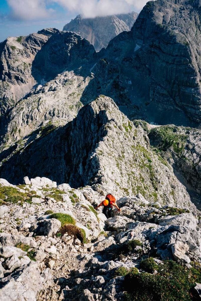
The climb to Sedlo Planja, the mountain saddle between Razor and Planja, is challenging. We recommend wearing a helmet like this women’s climbing helmet, or men’s climbing helmet for this part of the stage.
At the Planja saddle, you can hike to the summit of Razor and/or Planja. Or, you can simply enjoy your first glimpse of Mount Triglav and start the descent to Kriških podih.
The descending trail is secured with cables. Be extra careful on the descent, because you’ll be hiking down scree and loose rocky terrain.
After about 1-1:30 hours, the trail finally levels. As we hiked towards the Pogačnikov dom na Kriških podih, we saw two amazing things. First, we saw an ibex, and second the most beloved flower of the Alps, Edelweiss. The trail makes a final ascent to the mountain hut.
Stay in Pogačnikov dom na Kriških podih
This mountain hut is positioned high above Trenta Valley, surrounded by three alpine lakes. There’s something incredibly satisfying about enjoying the hut’s terrace with a well-earned Radler.
If you want to see Sp. Kriško jezero (1880 m), follow the trail in the direction of Trenta.
Reservation | Pogačnikov dom na Kriških podih – Online Reservation via Alpsonline
Payment | Cash only (though this may have changed in recent years)
Showers | None
Drinking Water | You can buy water.
Rooms | Shared rooms only

Triglav National Park Traverse Stage 2: Pogačnikov dom na Kriških podih – Koča na Doliču
Stage 2 of the Triglav Trek is phenomenal. After climbing over the mountain Bovški Gamsovec, you’ll be rewarded with heart-melting views of Mount Triglav. In July, the trail was lined with colorful wildflowers.
Stage 2 Trail Stats
Distance | 9.4 km
Time Needed | 6 hours
Elevation Gain | 1374 meters
Elevation Loss | 1250 meters
Difficulty | Difficult
Minimum Elevation | 1456 meters
Maximum Elevation | 2391 meters
Route | Pogačnikov dom na Kriških podih (2050 m) – Bovški Gamsovec (2391 m) – Luknja (1756 m) – Koča na Doliču (2151 m)
Lunch Option | None
Kriških podih – Bovški Gamsovec – Luknja -Koča na Doliču (6:30 hours)
Stage 2 of our Triglav National Park trek begins by crossing slabs of limestone before dramatically ascending to the mountain Bovški Gamsovec.
It takes about 1 hour to reach the Bovški Gamsovec ridge. The ascent is characterized by some semi-vertical secured scrambling. The path is secured with steel pegs and rungs.
Detour to the summit (optional) of Bovški Gamsovec.
Otherwise, the path continues over the ridge. There are incredible views of the northern wall of Triglav.
The descent to the Luknja mountain pass unfolds beautifully across carpets of wildflowers. Keep your eyes out for ibex.
As you near Luknja, you might see people climbing up the North Face of Triglav via the challenging Plemenice via ferrata route. This is also called the Bamberg route.
At Luknja, turn right and hike down the serpentine path.
When the trail eventually divides, turn left along the pod steno path. This part of the hike is uphill but very easy. There are sweeping valley views to your right. The trail then flattens out for a while.
The final stretch is another ascent to the mountain hut Koča na Doliču.
Stay in Koča na Doliču
Koča na Doliču is a popular hut, due to its proximity to Mount Triglav. Many hikers stay here, before climbing to the summit.
Those that book this self-guided Crossing the Julian Alps hiking tour can book Mount Triglav as an add-on. The IFMGA-licensed mountain guide will meet you at a designated location along the trek (likely Dolic hut) and supply all necessary via ferrata equipment.
After the summit climb, when you reach safe terrain, you’ll part ways with your hiking guide. We highly recommend booking this self-guided tour if you want to climb Triglav.
If you want to climb Triglav on another trip, read Hiking to Triglav from Pokljuka.
Koča na Doliču has a great location, but there are some downsides. There’s no running water. The toilet facilities are pretty gross (squat toilet).
You can only check-in at 4 pm, or later. If you arrive after 5 pm, you must notify the hut in advance. The food was okay.
If you opt for their half-board rate (which includes breakfast and dinner), the breakfast includes white coffee, which is a wheat-based coffee with milk, not real coffee.
If you want real coffee, you have to pay more. Other than that, it was clean and comfortable.
Reservation | Cash only (this may have changed in recent years)
Payment | Koča na Doliču – Online Reservation via Alpsonline
Showers | None
Drinking Water | You can buy water.
Rooms | Shared only

Triglav National Park Traverse Stage 3: Koča na Doliču – Koča pri Triglavskih jezerih
Today, you’ll venture into the Seven Lakes Valley, one of Slovenia’s most dazzling landscapes. The hike begins with summiting Kanjavec.
Along the route, there’s an opportunity to take a break at the perfectly situated mountain hut Zasavska koča na Prehodavcih, before starting the slow descent through the lake-dotted valley to the Triglav Lakes hut.
Stage 3 Trail Stats
Distance | 9.1 km
Time Needed | 5 hours
Elevation Gain | 479 meters
Elevation Loss | 943 meters
Difficulty | Moderately Difficult
Minimum Elevation | 1688 meters
Maximum Elevation | 2568 meters
Route | Koča na Doliču (2151 m) – Kanjavec (2568 m) – Zasavska koča na Prehodavcih (2071 m) – Koča pri Triglavskih jezerih (1685 m)
Lunch Option | Zasavska koča na Prehodavcih
Koča na Doliču – Kanjavec – Koča pri Triglavskih jezerih (5 hours)
We hiked to Seven Lakes Valley via Kanjavec.
If you’re looking at a map, you’ll notice that there are at least two other options. According to the hut staff at Koča na Doliču, the trail via Skozi rizo shouldn’t even be on the map, as it’s neither secure, nor safe. The other option is to go via Dolič saddle (2164 m) and Hribarice (2358 m), which is a popular route.
The hike to the Kanjavec summit takes about 1:30 hours. The trail is very manageable. However, shortly before reaching the summit, you’ll have to climb up a steep passage secured with ropes. That secured stretch is challenging, but only 5 meters in length.
During the ascent, Mount Triglav is visible. In the morning, it’s likely that you will have the whole mountain all to yourself.
After reaching the summit, the trail dives down across scree slopes. It feels really desolate on this side. When we hiked here in summer 2018, the trail markings were fading.
This rocky, karst terrain carried on until Zasavska koča na Prehodavcih. We took a detour to visit this mountain hut because we had sufficient time and wanted to rest. On the way to the hut, you’ll see the lake Rjavo jezero (2006 m).
To get back on the trail towards Koča pri Triglavskih jezerih (Triglav Lakes Valley Lodge), simply follow the signs. The path is well-marked.
The first gem you’ll pass is Zeleno jezero (1988 m), an emerald-colored lake with limestone boulders and a picturesque backdrop.
Further down the valley, you’ll pass the kidney-shaped Veliko jezero Ledvicka (1831 m). When illuminated by the sun, it glows with beautiful tones of teal and royal blue.
As you lose elevation, the trail gets increasingly more verdant. The path weaves through larch stands to reach the Tirglav Lakes hut.
Stay in Koča pri Triglavskih jezerih
The Seven Lakes Valley Hut is a stunner. Surrounded by crystal-clear lakes, it’s what hiking dreams are made of. One of the most spellbinding sites of this whole trek is seeing the mountains reflected in the waters of Dvojno jezero.
Reservation | Koča pri Triglavskih jezerih – Online Reservation via Alpsonline
Payment | Cash, or credit cards
Showers | The hut has running water. Unfortunately, the shower is no longer in operation.
Drinking Water | There’s a water fountain outside the hut.
Rooms | There are both private rooms and shared bedrooms available. This is a popular destination, so definitely book in advance.

Triglav National Park Traverse Stage 4:
On the final day of your hut-to-hut hike in Triglav National Park, you’ll leave the high mountains of the Julian Alps and hike across alpine pastures and through larch and later beech forests.
The first three days were filled with dramatic alpine landscapes. The final stage is full of romantic scenes of rustic alpine pasture huts and grazing cattle.
End the day with a swim in Lake Bohinj and a stay at Hotel Majerca, or Hotel Bohinj.
Stage 4 Trail Stats
Distance | 16 km
Time Needed | 6 hours
Elevation Gain | 497 meters
Elevation Loss | 1648 meters
Difficulty | Moderate
Minimum Elevation | 526 meters
Maximum Elevation | 1854 meters
Route | Koča pri Triglavskih jezerih (1685 m) – Štapce (1851 m) – Bregarjevo zavetišče na planini Viševnik (1620 m) – Koča na Planini pri Jezeru (1453 m) – Kosijev dom na Vogarj (1054 m) – Lake Bohinj (526 m)
Lunch Option | Bregarjevo zavetišče na planini Viševnik, Koča na Planini pri Jezeru, or Kosijev dom na Vogarj
Triglav Lakes Hut to Lake Bohinj (6 hours)
From the Seven Lakes Valley Hut, the trail ascends to the mountain ridge Štapce.
After hiking over Štapce, the gentle dwarf-pine-lined path continues southeast.
Follow signs to planini Viševnik.
You’ll cross a small alpine pasture with several huts called Ovčarija, before reaching Bregarjevo zavetišče na planini Viševnik (Bregarjevo Shelter on Plateau Viševnik). Bregarjevo used to be a cheese factory. In 1981, the old farm was transformed into a shelter, which offers overnight stays. It’s open from early June until the end of September.
Bregarjevo zavetišče is a charming place to relax and enjoy refreshments.
The trail continues to picturesque Koča na Planini pri Jezeru, which is situated above a lake and surrounded by wooden huts. This is an ideal place for lunch. They serve traditional Slovenian stews and soups.
From here, follow signs to Planina Vogar, signed 1:30 hours.
The trail is wide. After about 70-80 minutes, the trail joins a paved road for about 10 minutes. Follow the paved road until you see signs and a dirt road veering left and leading in the direction of Vogar.
You’ll pass by several huts and lodgings before reaching Kosijev dom.
At Kosijev dom, take a short 3-minute detour to a Lake Bohinj lookout point. You can grab a drink and bite to eat at this hut as well.
From Kosijev dom na Vogarj continue descending one hour to Lake Bohinj.
If the weather permits, swim in the clean and clear waters of Slovenia’s largest lake.
To complete the trek, walk directly to Stara Fužina, or Ribčev Laz, two villages located along the eastern shores of Lake Bohinj.
Stay around Lake Bohinj
Ribčev Laz
Ribčev Laz is the main hub at Lake Bohinj, with a direct bus connection to Lake Bled and onward to Ljubljana. Here, you’ll find a cluster of eateries, grocery stores, and boat rental shops.
Budget | Hostel pod Voglom is located along the southern shore of Lake Bohinj. This budget-friendly accommodation offers simple twin, single rooms, triple, and quadruple rooms. Bathrooms are either private, or shared. From the hostel, it’s a 20 minute walk (1.8 km) to Ribčev Laz, the closest village (restaurants, shops, etc…). You can rent kayaks, SUPs, and bicycles on-site.
Midrange | Apartments and rooms Cerkovnik is located in Ribčev Laz, a mere 10-minute walk to the lakeshore (1 km). This sparking clean accommodation offers double and triple rooms as well as well-equipped apartments. Breakfast is available for an additional fee. On-site parking is free.
Luxury | The newly renovated Hotel Bohinj is located in the center of Ribčev Laz, only a few meters from Lake Bohinj. Designed to impress as much as to pay homage to the region’s cultural heritage, Hotel Bohinj is the most striking hotel in the Bohinj region.
All rooms have air-conditioning. Guests are treated to a healthy and delicious breakfast buffet. You can also enjoy dinner at the hotel and indulge in a wellness package.
Look for accommodation in Ribčev Laz.
Stara Fužina
If you want to combine this hike with lakeside goodness and afternoon dips in Lake Bohinj, consider staying in Stara Fužina.
Midrange | Ideal for families, the top-rated Pr `Agotnik apartmaji sobe Bohinj offers spacious one- and two-bedroom apartments with fully-equipped kitchens, and washing machines.
Midrange-Luxury | Hotel Majerca is a lovely boutique hotel with an on-site restaurant in Stara Fužina. The restaurant extends onto a grassy lawn, with views of farmland backed by the Julian Alps. It’s wonderful to start and end your day here. The al fresco breakfast is phenomenal.
Midrange-Luxury | Apartmaji Triglav is a stylish aparthotel in Stara Fužina with an on-site restaurant and bar and spa and wellness center. Rooms are clean, modern, and feature balconies, kitchenettes and seating areas. Guests particularly love the mountain views and the hotel’s proximity to hiking trails and the lake. Breakfast is included.
Look for accommodation in Stara Fužina.

Plan Your Trip to Slovenia
Travel Destinations:
- Where to Stay in Slovenia
- Triglav National Park Travel Guide
- Lake Bohinj
- Lake Bled
- Kranjska Gora
- Pokljuka Plateau
- Logar Valley
- Kobarid
Itineraries:
Slovenia Hikes:
Europe:

Pin this Image for Future Trip Planning!
Stay Connected:
Connect with us on Pinterest.
Follow us on Instagram.
Like us on Facebook.
Support Us:
If you love reading our content, you can buy us a coffee via Ko-Fi.

Hello, thanks so much for sharing this hike. Me and some friends are going to do this in July. We are planning to do it independently and have booked all the huts. I was wondering if you would consider sharing your map for me to download?
Thanks so much,
Julia
Hi Julia,
You’re very welcome! Have a great trip hiking across the Slovenian Alps. Currently, we do not provide GPX data files (GPS).
Best,
Sabrina
Hey Julia,
Me and some friends are also doing this hike in July. I created a Komoot for it, in case you are interested in it.
Cheers,
Camilo