The island nation of Malta is a small archipelago located in the central Mediterranean Sea, between Sicily and North Africa. Malta comprises three islands, Malta, Gozo, and Comino, as well as uninhabited islets, Kemmunett (Comminotto) and Filfla.
Malta is by no means an established hiking destination. The Maltese hiking culture is in its infancy. Though there are well-defined paths, there are no trail signs and waymarking is sporadic.
Also, many existing trails cut across private land, or hunting grounds. Even with the aid of a guidebook, you may come across newly installed “Private Property,” “Do Not Enter,” and “RTO” signs, which prevent you from proceeding. Unfortunately, not all of these signs are legitimate.
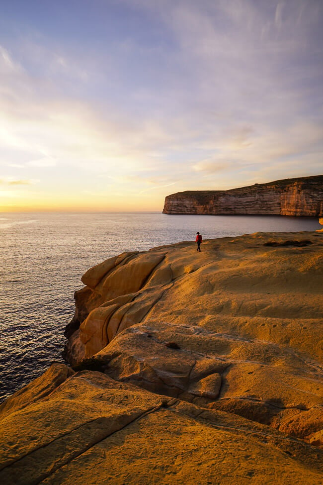
Despite some of the inherent challenges, hiking the coastlines of Malta and Gozo is a visual treat full of shimmering, vertical sea cliffs and secluded bays.
Another compelling reason to hike in Malta is that the hiking season runs from late Fall until early Spring. Even in the middle of the winter, you’ll likely experience blue skies and mild temperatures.
We hiked in Malta in late February and the weather was mostly stable (just windy at times), flowers were blooming, and the trails were extremely peaceful.
In this Malta hiking guide, we’ve outlined our favorite coastal trails in Malta and Gozo and shared more insights and tips regarding what to expect, what to pack, and where to stay.
Malta Hiking Tips
- When to Hike: Late October – Early May. Avoid hiking in summer.
- Signage and Trail Markers: Waymarking is sporadic and inconsistent. Waymarks are usually red, blue, or yellow painted dots and arrows. There are no trail signs.
- Best Hikes in Malta: Golden Bay to Gnejna Bay and Migra I-Ferha to Ras id-Dawwara
- Best Hikes in Gozo: Xlendi Bay to Sanap Cliffs, Dwejra Bay, Ta’ Cenc Cliffs, and Mgarr Harbor to Hondoq ir-Rummien Beach
- Hiking Guidebook: Cicerone: Walking on Malta
- Where to Stay in Valetta, Malta Island: Casa Asti (budget), Ursulino Valletta (midrange), The Phoenicia Malta (luxury), or 66 Saint Paul’s Boutique Hotel (luxury).
- Where to Stay in Victoria, Gozo Island: B&b la Fenice by giancarlo (budget), Maria Townhouse Heart of Victoria B&B (midrange), or The Duke Boutique Hotel (luxury).
Malta Hiking Map
1. Golden Bay to Gnejna Bay

Golden Bay is located in the northwest coast of Malta, near the village of Manikata. A short but nonetheless fantastic circuit trail leads from Golden Bay to Ġnejna Bay, passing various beaches and coastal watch towers along the way.
To begin this hike, walk down to Golden Bay Beach. There’s a footpath that connects the southern-end of the beach up to a walking path on the cliffs. Once you’ve joined the flat cliffside walking path, continue heading south to the Għajn Tuffieħa Tower, overlooking the Għajn Tuffieħa Bay – a popular surfing spot.
From the tower, the trail heads inland to the Għajn Tuffieħa Bay parking lot, passing a coffee shop van, serving a tempting selection of hot and iced coffees.
From the parking lot, there are several paths leading south. Continue right as if you’re heading to the beach, but quickly bear left. This path runs parallel to the Għajn Tuffieħa beach (not on the beach) and leads to the narrow neck of the Il-Qarraba promontory. The slender neck rises between Għajn Tuffieħa Bay and Qarraba Bay.
When you get to the neck, we recommend following the circuit path counter-clockwise around Il-Qarraba.
The path is mostly clear, but there are a few places which require some guessing. There are some red-painted waymarks, but these trail markers are few and far between.
After completing the circuit around Il-Qarraba, follow the neck uphill to the striking clay cliffs. The coastal path continues south, and soon towards the limestone tongue projecting out into the bay. The steep passages are somewhat tricky because of the terrain.
You can detour down to the tongue (option), before continuing south. After tackling another steep descending passage, the trail cruises along the coast in the direction of Gnejna Beach.
Next, head to the Ta’ Lippija Tower. When the path splits, stick to the left path. Ignore the steep trail that climbs up to the tower.
Stay on the easy, level path, heading south. Eventually, this trail reaches a point overlooking the parking area of Gnejna Beach. Make a sharp left here and ascend up to the plateau, where the tower is situated. Some (very little) scrambling is needed to reach the plateau.
With sweeping views of Gnejna Bay and Il-Qarraba, continue north on this wide elevated trail.
Eventually, the path steers inland across a rocky karst plateau and then makes a U-turn back to the coast. The path continues north once again, parallel but high above the Għajn Tuffieħa Beach.
You’ll hike up a sandy hill and then descend to the Għajn Tuffieħa parking lot, where that coffee shop van is located.
From here, follow the familiar path to Golden Bay via the Għajn Tuffieħa tower.
You can descend to Golden Beach, or stay on the main trail, which spits you out on Triq In-Nahhalija road. When you get to the road, head left. You’ll pass the Apple’s Eye restaurant, which is located directly across from the parking lot.
Golden Bay to Gnejna Bay Trail Stats
Where | Malta Island
Trailhead | Golden Bay Beach
Free Parking | Google Maps
Bus Stop | Ghajn Tuffieha Bus Terminus (44 Valletta, 101 Ic-Ċirkewwa, 101 Mgarr, 223 Bugibba, 225 Sliema Ferries/Valletta, TD5 Tas-Sliema)
Distance | 5.8 km circuit
Time Needed | 2:15 hours
Difficulty | Moderate
Where to Stay | Radisson Blu Resort & Spa, Malta Golden Sands (luxury) at Golden Bay
2. Migra I-Ferha to Ras id-Dawwara Coastal Hike

Migra I-Ferha (Miġra l-Ferħa) is a small inlet in the southwest coast of Malta. Though logistically unlikely, local tradition asserts that Norman Count Roger and his troops landed at Migra I-Ferha in 1091, before laying siege to Muslim-ruled Mdina.
The romanticized Norman Invasion resulted in the release of Christian captives, but no major political change.
A splendid coastal trail leads southeast from the parking lot at Migra I-Ferha to the Ras id-Dawwara cliffs. We hiked until we spotted the first “RTO” sign. From the trail, you can see a number of sea caves.
This hike is only 4.7 km out-and-back and takes 1:30 hours total.
You can extend the Miġra l-Ferħa hike northwest along the coast all the way until Il-Blata tal-Melh salt pans.
Migra I-Ferha to Ras id-Dawwara Trail Stats
Where | Malta Island
Trailhead | Migra I-Ferha Parking Lot
Free Parking | Google Maps
Bus | Not accessible by bus.
Distance | 4.7 km out-and-back
Time Needed | 1:30 hours
Difficulty | Easy
Where to Stay | The Xara Palace Relais & Chateaux (luxury) in Mdina
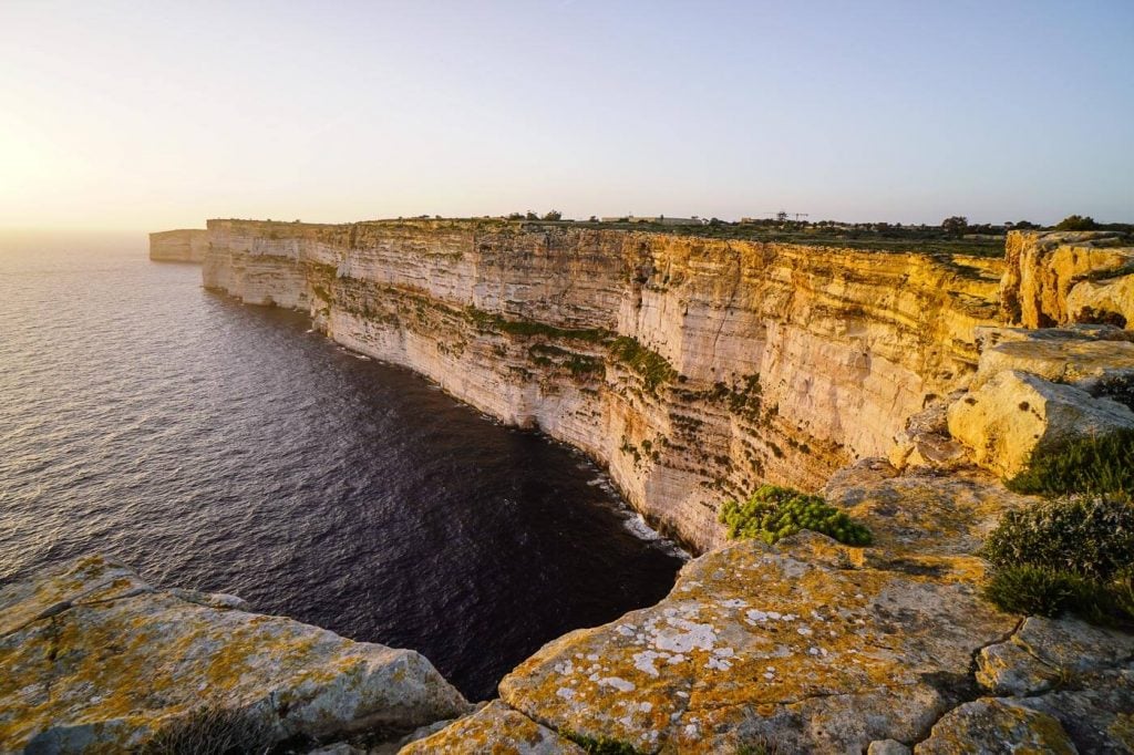
3. Xlendi Bay to Sanap Cliffs Hike

The out-and-back hike from Xlendi Bay to the Sanap Cliffs (sometimes called Ta’ Saguna Cliffs) is the best coastal hike on Gozo Island. It follows the Munxar-Xlendi Heritage Trail and showcases Gozo’s pristine coastline.
To start this hike, head to the seaside village of Xlendi in the southwest of Gozo, close to Munxar and Fontana.
Walk to Xlendi Beach and follow the pedestrian path along the bay. The paver walkway wraps around the bay to an idyllic picnic area with a smattering of benches. After crossing a stone bridge, the trail ascends to the Ras il-Bajda cliffs, home to the historic Xlendi Tower, which dates back to 1650.
Continue south along the high cliffside trail. You’ll pass a sheltered cove and then join another paver walkway, which leads to the Sanap Cliffs.
When the paver walkway ends, continue following the coast all the way to Il-Pinnur Point.
Return to Xlendi Bay along the same trail.
Xlendi Bay to Sanap Cliffs Trail Stats
Where | Gozo Island
Trailhead | Xlendi Beach
Free Parking | Google Maps
Bus | You can take bus line 306 from Victoria to Xlendi.
Distance | 7.1 km out-and-back
Time Needed | 2:40 hours
Difficulty | Easy
Where to Stay in Xlendi | San Antonio Guesthouse – Bed & Breakfast (budget), or Viewpoint Boutique Living Xlendi Gozo (midrange-luxury)
Learn More: Sanap Cliffs Hiking Guide
4. Dwejra Bay Coastal Walks

Dwejra Bay is located in the western coast of Gozo in San Lawrenz. Defined by striking cliffs, rocks, fossil beds, and even a nearby lagoon, Dwejra Bay is a great destination for walking.
It’s also the former site of the Azure Window (Dwejra Window), a natural limestone arch which unfortunately collapsed in 2017 in a storm. The Azure Window was famously featured in the Dothraki wedding scene in the first season of Game of Thrones.
From the parking lot/bus stop at Dwejra Point (Id-Dwejra), you can follow the coastal trail north, or south. Both trails abruptly end at “private property keep out” signs.
We hiked the north trail (5.8 km out-and-back) and then continued hiking the south trail (7.1 km out-and-back).
Where | Gozo Island
Trailhead | Id-Dwejra / Dwejra Point
Free Parking | Google Maps
Bus | Dwejra Bus Stop, Route 311 Victoria – Dwejra
Where to Stay in San Lawrenz, Gozo | Shanti Ghar Gozo B&B (budget), Soleil B&B Gozo – Adults only (midrange), or Kempinski Hotel San Lawrenz Malta (luxury)
Dwejra Bay North Route
Starting at the St. Anna Chapel, the trail ascends with bird’s-eye views of the Inland Sea, a lagoon linked to the sea through a natural tunnel.
Follow the steps, carved into the stone. The path makes a sharp left, signaled by a red painted arrow, and leads to the cliffs. The cliff top trail follows the coast for 2 km, guided by the occasional red painted waymark.
After passing a striking sandstone formation, the footpath continues for another 15 minutes, ending at a “Private Property Keep Out” sign.
We returned to the St. Anna Chapel and parking area along the same trail.
Distance | 5.8 km out-and-back
Time Needed | 2 hours
Difficulty | Easy
Dwejra Bay South Route
From the upper parking area, follow the trail south, towards the coastal watch tower. Pass the tower and continue until you reach a stone wall (private property perimeter) and a “Go This Way” printed sign. At the wall, head right (south).
From here, it’s easy to miss the main trail. The trail bears left, heading inland for a few meters, before ascending to the cliffs. If you hug the coast (staying right), you’ll have to scale a cliff to rejoin the trail (not difficult, just a bit confusing).
The coastal trail delivers sweeping views of Dwejra Bay, Fungus Rock and the Sea.
Like the northern trail, the path comes to a sudden and premature end.
We ventured a bit further, turning around at a lovely lookout point with views of Xlendi Bay.
Distance | 7.1 km out-and-back
Time Needed | 2:50 hours
Difficulty | Easy
5. Ta’ Cenc Cliffs Hike
Reaching a soaring height of 138 meters above sea level, the Ta’ Cenc Cliffs are the highest sea cliffs on Gozo Island. These sheer limestone cliffs are located along the island’s southern coast, near the village of Sannat.
The Ta’ Cenc Cliffs viewpoint area is privately owned. However, access is allowed. But please remember, you’re a guest here.
And, I imagine this gorgeous strip of coastline will only stay accessible to the public so long as visitors are respectful and quiet. That means, no drones, no dirt bikes, no music, etc…
This trail starts in Sannat either at the Cenc Bus Stop (if you’re arriving by bus) or at the gravel parking area on Triq tal-Kalkara road (if you’re traveling by car).
Ta’ Cenc Cliffs Trail Stats
Where | Gozo Island
Trailhead | Triq tal-Kalkara Road, Sannat
Free Parking | Exact Location: Google Maps
Bus | Cenc Bus Stop in Sannat. Route 305 Victoria -Ta Sannat – Victoria
Distance | 9.1 km out-and-back
Time Needed | 2:45 hours
Difficulty | Easy
Where to Stay | Hotel Ta’ Cenc & Spa (luxury) in Sannat, Gozo or The Duke Boutique Hotel (luxury) in Victoria, Gozo
Learn More: How to Get to the Ta’ Cenc Cliffs Viewpoint
Cenc Bus Stop to Ta’Cenc Cliffs Trailhead/Parking
From the Cenc bus stop, follow the road in the direction of Hotel Ta’ Cenc & Spa. The road soon divides, with the right road leading to the hotel, and the left road leading to an empty lot.
Head left and cross a lot behind the hotel, and then follow the signs to the tennis court. The pedestrian path brings you to the paved Triq ta’ Skerla road, which turns into Triq tal-Kalkara road. At the paved road, turn right and walk 4 minutes to the trailhead.
The trailhead isn’t marked, or signed. But, there’s a long strip of gravel along the road, where people park.
Ta’ Cenc Cliffs Walk
Turn right in the direction of the coast. Take the right trail, which leads directly to the cliffs.
When you reach the cliffs, there’s a nice view to the east, but don’t stop here.
Turn left and follow the coastal path to the cliff plateau, arching to the sea. There are no barriers, so be extra cautious around the cliff edge.
As you progress, the views unravel magnificently. The vertical-faced Ta’ Cenc Cliffs stretch out to the west, seemingly endlessly.
This is the highlight of the hike. And, if you’re pressed for time, there’s no need to go any further.
However, you can continue east to Ras in-Newwiel point, the Mġarr ix-Xini Bay (what we did) or even all the way to Mgarr and the Gozo Ferry Terminal.
Use Maps.me or another GPS navigation tool to navigate. Paths diverge and it’s not always clear which path to take.
If you continue east, don’t miss Ras in-Newwiela point (GPS: 36.01219, 14.26128), a peaceful headland which boasts photo-worthy views. The main trail bypasses the headland. So, you’ll have to make a conscious effort to head down to the coast.
Learn More: Ta’ Cenc Cliffs Viewpoint
6. Mgarr Harbor to Hondoq ir-Rummien Beach Coastal Walk

This short and sweet coastal walk starts at the Mgarr Harbor and ends at Hondoq ir-Rummien, a tiny Blue Flag beach. The path is very narrow and sometimes overgrown with thistle. Parts of the path are eroding, so be careful.
The path hugs the coast, passing some scenic coves along the way. The best view is of the Il-Gebel tac-Cawl rock, which is narrowly connected to the mainland.
Hondoq ir-Rummien Beach is a small, sheltered sandy beach, which is a popular spot for snorkeling. There are public toilets near the beach.
Mgarr Harbor to Hondoq ir-Rummien Beach Trail Stats
Where | Gozo Island
Trailhead | Mgarr Harbor / Gozo Ferry Terminal
Free Parking | There’s a free covered parking area at the Mgarr Harbor. Exact Location: Google Maps.
Bus | Gozo Ferry Terminal
Distance | 4.2 km out-and-back
Time Needed | 1:10 hours
Difficulty | Easy
Where to Stay in Victoria, Gozo | B&b la Fenice by giancarlo (budget), Maria Townhouse Heart of Victoria B&B (midrange), or The Duke Boutique Hotel (luxury)
What to Know about Hiking in Malta

When to Hike in Malta
Late October – Early May.
Avoid summer months, as the temperatures are scalding.
Private Property Signs
Private property signs are littered across Malta and Gozo. It’s a point of contention, because signs are installed regularly on both private and non-private lands.
The Rambler’s Association of Malta aims to “protect the public’s rights of way through both public paths and other passages which have been trodden by the public for ages.” But, they have some ways to go.
Safety
The coralline limestone cliffs are quite brittle. Keep a safe distance from the cliff edge.
We didn’t encounter any stray dogs, or guard dogs along these trails.
Signage and Waymarking
Waymarking is sporadic and inconsistent. Waymarks are usually red, blue, or yellow painted dots and arrows.
There is no signage.
Getting Around Malta and Gozo
It’s possible to get around the islands using public buses: Malta Public Transport. The bus routes are synced with Google Maps. But, not all places will be accessible by bus.
We rented a car for our trip to Malta in February. Overall, we’d recommend renting a car, because it gives you far more flexibility and saves you a lot of time.
However, driving in Malta and Gozo is a challenge. The Maltese drive on the left side of the road. There’s a lot of congestion and traffic, which makes driving stressful. Kati is an excellent driver, so she managed really well. If I had driven, I probably would have cried a few times.
We suggest using the Discovercars.com car rental reservation platform to search for and book car rentals in Malta. This easy-to-use booking platform compares car rental deals from 500+ trusted providers, so that you can choose the best option for your trip.
Tip: If you can only drive automatic transmission cars, as opposed to manual transmission cars (stick shift), book your car rental as early as possible.
Parking was never a problem at the trailheads. There was always plenty of parking availability. That being said, we visited in February, firmly off-season. During shoulder season (October, April, May), parking may be more difficult.
Where to Stay in Malta for Hiking
We recommend splitting your time between Malta and Gozo. Gozo is home to the most dramatic coastal landscapes of the archipelago.
While you can easily visit Gozo as a day trip from Malta, the island deserves more time. The most central and lively place to stay on Gozo is the capital city of Victoria.
Valletta, Malta Island
Valletta is the vibrant capital city of Malta and a UNESCO World Heritage Site. The honey-colored city is perched between two natural harbors, Grand Harbor and Marsamxett harbor, and enclosed by imposing bastion walls.
It’s a striking, fortified city brimming with Baroque architecture, narrow streets accented by colorful covered balconies (gallariji), wide-open piazze, and darling cafés.
There’s a lot to see and do in and around Valletta, including visiting St. John’s Co-Cathedral, the Lower and Upper Barrakka Gardens, the Three Cities, and the Sliema promenade. Check out these tours:
- Valletta: 3-Hour Walking Tour
- Valletta: Street Food and Culture Walking Tour
- Valletta: Guided Walking Tour with St. John’s Co-Cathedral
- Valletta and 3 Cities Private 4-Hour Shore Excursion
Traffic within the city is restricted and many roads are pedestrian-only. This is a great base if you’re visiting without a car, as Valletta is well-connected by bus and by ferry to other parts of the island as well as Gozo (e.g. Gozo Fast Ferry).
Budget | Casa Asti is a budget-friendly and sparkling-clean guesthouse, located near the Upper Barrakka Gardens. Guests love the location and the staff.
Midrange | Ursulino Valletta is a bed and breakfast set in a modern post-war building on a quiet street in the city center. Guests love the sleek interior design and sea views from the rooftop terrace. A fabulous breakfast is served on the rooftop.
Luxury | The Phoenicia Malta is an elegant art deco hotel, situated just outside Valletta’s City Gate. The Phoenicia dazzles with its airy 1920s-style interiors, large terrace overlooking the city walls, outdoor infinity pool, and Deep Nature Spa facilities (indoor pool, steam room, Finnish sauna), free for hotel guests. Breakfast is served daily in the Phoenix Restaurant.
If you’re looking for a luxury option within the city walls, check out 66 Saint Paul’s Boutique Hotel.
Look for accommodation in Valletta.
Victoria, Gozo Island
Victoria (Citta’ ir-Rabat) is the vibrant capital and beating heart of Gozo Island. Perched on a hilltop in the middle of the island, the historic city of Victoria serves as a busy crossroads, where all roads converge.
Here, you’ll find a plethora of accommodations, restaurants, cafés, and historic buildings, including the impressive medieval Cittadella. Stay here if you’re traveling without a car.
Budget | B&b la Fenice by giancarlo is a clean and tidy bed and breakfast in Victoria with rave reviews. Guests love the views of the Citadel and the warm hospitality of the host. Street parking is free in front of the building.
Midrange | Maria Townhouse Heart of Victoria B&B is tucked away on a quiet pedestrian street in historic Victoria, walking distance to St. George’s Square, Independence Square, the Citadel, and the bus station. With its charming atmosphere, limited capacity (only 4 rooms) and a room-delivered breakfast, staying here is a treat. Guests have access to a communal kitchen and washing machine. This is an ideal place to stay, if you’re traveling without a car. There’s no on-site parking.
Luxury | Located in the center of Victoria on the 4th and 5th floors of a shopping mall, The Duke Boutique Hotel pampers guests with its spacious and modern rooms, citadel-gazing terrace, and superb breakfast. Rooms are sound-proofed and have air-conditioning. There’s free parking in the public car park behind the hotel, or hotel parking (10 EUR extra charge).
Look for accommodation in Victoria.

Malta Hiking Essentials
Hiking Gear
- Hiking Backpack: Osprey Tempest 30 Women’s Backpack / Osprey Talon 33 Men’s Backpack
- Grade B or B/C Hiking Boots: Meindl Schuhe Island Lady (Kati’s Boots), Women’s Hanwag Tatra II GTX (Sabrina’s Boots), Men’s Hanwag Tatra II GTX (men’s equivalent)
- CAT 4 Sunglasses: Julbo Shield Mountain Sunglasses
Photography Gear
- Camera Body: Sony Alpha a6400
- Mid-range Zoom Lens: Sony Vario-Tessar 16-70mm F4 ZA OSS ZEISS
- Wide angle Zoom Lens: Sony – E 10-18mm F4 OSS Wide-angle Zoom Lens
- Backpack Camera Clip: Peak Design Camera Clip
Malta Hiking and Travel Guidebooks
- Hiking Guidebook: Cicerone: Walking on Malta
- Travel Guidebook: Lonely Planet: Malta & Gozo
- Hiking Guidebook (German Language Only) Rother: Malta & Gozo
Malta:
Southern Europe Hiking Trails:
- Best Hikes in Portugal
- Best Hikes in Mallorca
- Best Day Hikes in Tenerife, Canary Islands
- Best Day Hikes in Gran Canaria, Canary Islands
European Alps Hiking Trails:
