Marwees is a mountain in the heart of the Alpstein massif in the Appenzell Alps of Appenzell Innerrhoden, Eastern Switzerland.
Marwees rises between the valley of Lake Seealpsee and the valley of Widderalp.
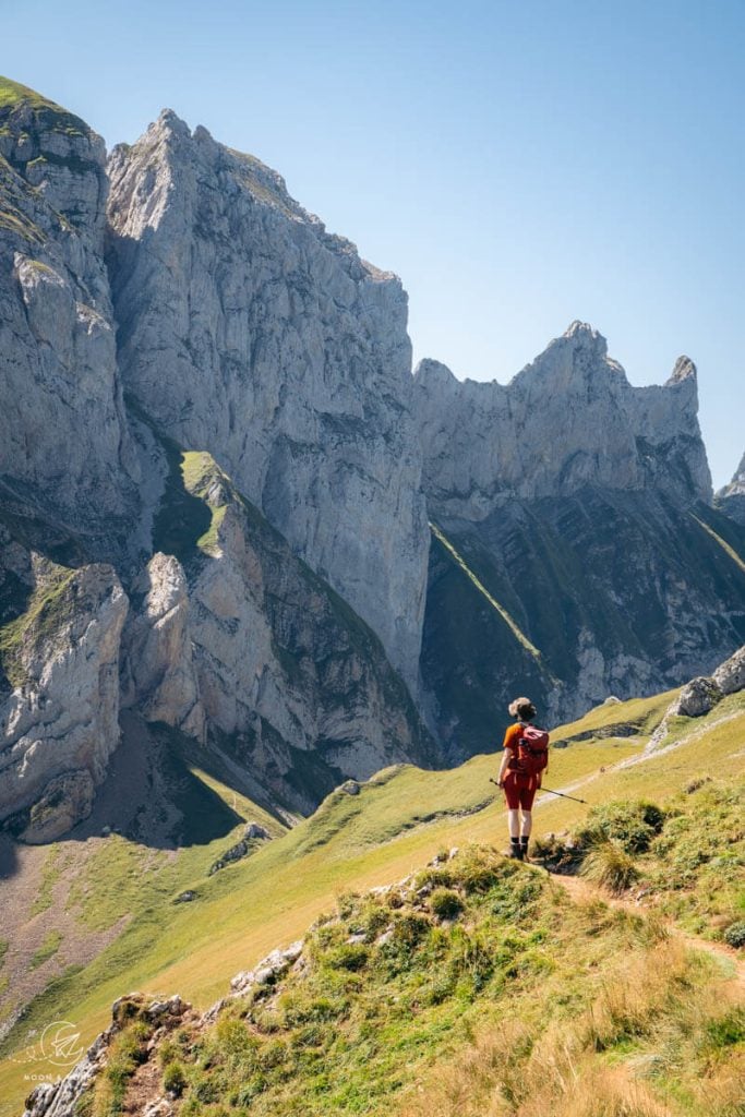
The Marwees ridge trail is one of the most rewarding and demanding hikes in Appenzell. It gives hikers a vast overview of the area, because the Marwees spine affords 360° views the Alpstein’s Eastern Ridge (Hoher Kasten – Saxer Lücke), neighboring Widderalpstöck-Hundstein Ridge, and the Northern Ridge (Schäfler – Altenalp Türm – Säntis), along with all the valleys in between.
Extremely varied and exciting, this circuit trail links Wasserauen with the 1.5-km-long Marwees ridge, Meglisalp mountain pasture, and Lake Seealpsee.
If you love ridge hikes and you have no fear of heights, add this route to your Appenzell Itinerary. It’s important to only tackle this Appenzell hike in stable weather and in dry conditions.
- Trailhead: Wasserauen | Google Maps
- Distance: 14.5 km circuit
- Time Needed: 6:45 hours
- Elevation Gain/Loss: 1225 meters
- Difficulty: Difficult
- Minimum Elevation: 871 meters
- Maximum Elevation: 1990 meters
- Route: Wasserauen – Klein-Hütten – Bogartenlücke – Marwees – Widderalpsattel – Bötzelsattel – Meglisalp – Seealpsee – Wasserauen
- Where to Stay in Appenzell Village: Alte Metzg – Hostel (budget), Blattenheimat (midrange), Hotel B&B Stossplatz (midrange), or Hotel Appenzell (luxury)
- Where to Stay in Weissbad Village: Weissbad Lodge (midrange), or Hotel Hof Weissbad (luxury)
- Where to Stay in Schwende: Hotel Frohe Aussicht (midrange)
- Weissbad (luxury)
- Recommended Trail Map: K+F 09, Appenzell, Säntis, St. Gallen 1:40.000
Marwees Ridge Trail Hiking Map
Marwees Trail Difficulty

The Marwees – Meglisalp circuit trail follows white-red-white (moderate) and white-blue-white (difficult) hiking trails.
The most difficult section of the hike, marked in white-blue-white, is the Marwees ridge, between the Bogartenlücke saddle and the Widderalpsattel saddle.
The path is steep and extremely narrow at times. This is something you shouldn’t do after rain, or if the weather is unstable. When wet, the path could potentially be treacherous.
Is this the most difficult hike we’ve ever done? Absolutely not.
Where to Start the Marwees Ridge Hike
Wasserauen

Wasserauen is a small settlement in Schwendetal Valley at the foot of the Alpstein.
It’s the southern end station of the Gossau–Wasserauen line of the Appenzell Railways. You can take a direct train from Schwende, Weissbad, Steinegg, Appenzell, and other stations to Wasserauen.
In addition to the train station, Wasserauen is where the Ebenalp cable car valley station is located. Many visitors flock to Ebenalp to hike to the world-famous Berggasthaus Aescher and the Schäfler Ridge Viewpoint.
Wasserauen is also the closest trailhead to Lake Seealpsee, another extremely popular destination in the Appenzell Alps.
Needless to say, Wasserauen is a very busy trailhead.
There’s a large paid car park at Wasserauen, between Hotel Alpenrose and the Wasserauen Bahnhof. You can pay the parking fee with a parking app, or with Swiss Francs (coins only, exact change only).
If you stay in the Appenzell region for 3, or more nights, you will receive a “Appenzeller Ferienkarte,” which gives you free transit on regional buses and trains as well as cable cars (e.g. Hoher Kasten, Ebenalp).
Wasserauen – Bogartenlücke – Marwees – Meglisalp – Seealpsee Circuit Trail Description
Wasserauen to Klein-Hütten Trail Junction (35 minutes)

The Marwees trailhead is located at the paragliding landing area, marked by the Paragliding School shipping container, next to the Wasserauen car park.
Pass through the turnstile to access the trail.
Note: there are no trail signs directly at the trailhead. The closest trail signs are located at the road, a few meters away.
Ascend the grassy meadow. The trail soon merges with the path from Hotel Alpenrose. At the junction, turn left to Seealpsee.
Reinforced with timber and metal steps, the forest trail ascends steadily through a beech forest.
After about 20 minutes, you’ll arrive at a metal pasture gate with various signs. Here’s what the signs mean:
Ab hier müssen Sie Ihren Hund an der Leine führen: Starting here, you must keep your dog on a leash.
Sicherheitsabstand zu Kühen and Rindern unbedingt einhalten. Keinesfalls berühren. Always keep a safe distance from cows and cattle. Never touch.
Pass through the pasture gate. Right away, you’ll see the Bogartenlücke saddle between Bogartenfirst and Marwees. The saddle is bisected by a single spire, which is called Bogartenmannli.
A series of gravel steps steer you across the meadow to the Klein-Hütten trail junction (1179 m).
Turn left, following the sign to Bogarten (1:30 hours).
Klein-Hütten Trail Junction to Bogartenlücke Saddle (1:30 hours)

The Bogartenlücke-bound trail ascends the mountain pasture, where cows graze in summer.
Cross the timber pasture fence, where the rocks have been strategically stacked, and then turn left.
The dirt trail leads northeast for a few meters and then continues uphill in serpentines. Throughout the ascent, you’ll be able to see Ebenalp, Berggasthaus Schäfler, Altenalp Türm, Öhrli, Höch Nideri, Hüenerberg, Girenspitz, and Säntis.
The ascent continues through beech forest up to the Alp Mans mountain pasture.
At the next trail junction, turn right to Bogarten.
The trail steepens as it crosses the tree-studded slope.

Exit the Alps Mans pasture at the kissing gate and wind through the boulders.
At the next junction, turn right to Bogarten (white-red-white) and Marwees and Meglisalp (white-blue-white).

It’s a steep push up to the saddle. Pass through the pasture gate at the Bogarten saddle and you’ll see the tips of the Kreuzberg Peaks, Saxer Lücke, and Berggasthaus Bollenwees.
The happily-situated hut below is Alp Bogarten.
Bogartenlücke Saddle to Marwees Eastern Summit (1 hour)

The Bogarten (1682 m) trail junction is located just below the saddle. Marwees is signed 1 hour and Meglisalp is signed 2:40 hours.
There’s a cautionary alpine route sign bolted to the rock, which describes, in four languages, the meaning of a blue alpine trail:
- Particularly dangerous footpath
- Passable at your own risk!
- Only for experienced hikers without vertigo
- Keep an eye on the weather.
- Tour takes some hours
- Dangerous when wet.
Clearly etched across the grassy landscape, the Marwees-bound trail dips down initially, levels, and then twists up the slope in tight switchbacks.
The twisting ascent traces a steep channel, bordered by the Dreifaltigkeit wall made up of three blade-like spires.
Steep steps bring you to a minor saddle between Marwees and Dreifaltigkeit. The trail makes a sharp right and continues to ascend.
Traverse the grassy flank of Marwees in a northeasterly direction. There are some narrow, rugged parts. The path is marked with white-blue-white timber posts.
With elevation gain, views open up to Alp Sigel, Hoher Kasten, crowned with a weather station, and Lake Sämtisersee.

Eventually, the dirt trail swings left and ascends the Marwees ridge. You’ll once again see Ebenalp, the Schäfler Ridge and as you progress, Lake Seealpsee as well.

It’s a very steep climb to the Marwees Eastern Summit (1991 m), which bears a simple cross, a bench, and trail signs (45 minutes to Widderalpsattel, 1:40 hours to Meglisalp).
The Marwees Eastern Summit invites you to take a deep breath and delight in the alpine panorama before you.

Marwees Eastern Summit – Marwees Ridge – Widderalp Saddle (35 minutes)

The hardest part is over in terms of sheer physical effort.
In dry conditions, the narrow Marwees ridge is an absolute joy to hike.
To your left, you’ll see Widderalp beneath the serrated ridge of Widderalpstöck (2058 m), Hundstein (2157 m), and even Altmann (2435 m).
Follow the ridge and descend to Widderalpsattel, the mountain saddle between Marwees and Hundstein.

Along the way, there are two rugged, descending stretches that require extra caution.
The path skirts the highest point of the Marwees ridge. Note: there is no official trail that leads to the Marwees western summit (2056 m).

The path traverses a mountain pasture. As you draw closer to the saddle, the views of Hundstein are increasingly impressive.
Soon after crossing the second stile over a pasture fence, the trail descends a slippery scree path to the Widderalpsattel trail junction. Hiking poles like these Unisex Black Diamond Hiking Poles are helpful in stabilizing this descent.

Note: it’s possible to ascend to Hundstein from this intersection.
Widderalp Saddle to Bötzel Saddle (15 minutes)

Turn right to Meglisalp, signed 55 minutes.
The way to Bötzel saddle curves above the basin in a semicircle shape. Cling to the mountainside and cross the sturdy scree slopes.
Don’t take the unofficial path that descends across the basin.
Bötzel Saddle to Meglisalp Mountain Inn (35 minutes)

From the Bötzel saddle, you can see Meglisalp mountain pasture below, a congregation of huts surrounding the large Meglisalp mountain inn.
The descent is well-graded and quite enjoyable.
The path passes through Spitzigstein mountain pasture on the way down to Meglisalp.

Meglisalp is buzzing with hikers and cows. If you arrive here on a Sunday, there are services in the chapel, enhanced by Alphorn music.
We ate lunch at Berggasthaus Meglisalp, before continuing onwards. Payment is accepted in cash and by card.
In addition to the mountain inn, there’s also a dairy, Chäshötte, that sells Rahmkäse cheese and Schliperchäs cheese.
Meglisalp Mountain Inn to Lake Seeaplsee (1 hour)

Follow the gravel trail past the chapel.
The path develops into a balcony, high above the Seelapsee valley.
With time, the trail descends, clinging to the mountain wall. Much of the path is bolstered with timber reinforcements and protected with cables.
Accompanied by lake views, the descent continues, more rugged and rockier than before, into a mixed forest.
Zigzag down the forest to the western shore of Seealpsee.
Lake Seealpsee to Wasserauen (1 hour)

A wide, flat trail wraps around Lake Seealpsee. You can go either way, but we recommend going left towards Seealp and following the northern shore.
The views of the lake, backed by Marwees, are particularly lovely in the late afternoon.

Follow the Seealpsee circuit trail to Berggasthaus Seealpsee and then continue down the wide road to Wasserauen.
Where to Stay in Appenzellerland
Appenzell Village

The lovely town of Appenzell is the capital of the Swiss Canton of Appenzell Innerrhoden. Surrounded by beautiful countryside, Appenzell is a picturesque town with colorful gabled buildings that house delicious bakeries, restaurants, hotels, apartments, and museums.
Accommodations are always clean and comfortable, but modest. There are no 5-star hotels in this area of Switzerland.
We recommend staying in, or near the village center of Appenzell, because of the dining options and cultural activities (museums and art galleries). After long hikes in the Alpstein, it’s ever so nice to end your day in the heart of Appenzellerland.
Appenzell is also a great base for those traveling without a car. With train connections to Wasserauen and Weissbad (bus transfer to Brüllisau), it’s effortless to get around to various trailheads.
Budget | Alte Metzg – Hostel offers 3 spotless rooms with communal bathrooms and kitchen facilities. This intimate hostel is walking distance to the Appenzell village center and train station. On-site parking is available, but must be reserved in advance (fees apply). They also run the neighboring midrange Alte Metzg Boutique Pension with private single, double, and family rooms.
Midrange | Blattenheimat – im traditionellen Appenzeller Haus (2 nights minimum stay) is a traditional, gabled house with 2-3 bedroom apartments and free private parking, very close to the Hauptgasse (pedestrain main street of Appenzell). Guests have access to a washing machine and dryer in the basement.
Midrange | Located very close to the Appenzell train station, Hotel B&B Stossplatz is a darling bed and breakfast with free private parking, free bikes, and a shared lounge. Rooms either have shared, or private bathrooms.
Luxury | Hotel Appenzell is located on the historic Landgemeinde Square in the center of Appenzell village. Boasting an excellent restaurant with an outdoor terrace as well as a confiserie (patisserie), this traditional Appenzell hotel is a great option for your stay. Breakfast and parking are included in the rate.
Luxury | Adler Hotel is centrally located at the start of the pedestrian Hauptgasse (main street), across from the Parish Church of St. Mauritius and the Metzibrücke Bridge. This traditional hotel with two restaurants is a great place to stay if you’re traveling without a car. No parking available on-site.
Look for accommodation in Appenzell.
Weissbad Village
Weissbad is a quiet village in Schwendetal Valley between Appenzell and Wasserauen.
Situated on the Gossau–Wasserauen train line of the Appenzell Railways, Weissbad is a great base for exploring the region. It takes a mere 6 minutes to reach Appenzell village by train. It takes only 10 minutes to ride the train to Wasserauen (Ebenalp cable car valley station, Seealpsee trailhead, Marwees trailhead, etc…). And, it’s only an 8-minute bus ride to Brüllisau (Hoher Kasten cable car, Saxer Lücke and Fählensee trailhead).
Midrange | Weissbad Lodge, not to be confused with the nearby sister property of Hotel Hof Weissbad (luxury), is a comfortable accommodation with spacious, modern rooms and free on-site parking. The lodge is located on the bank of the Sitter River, just a block away from the Weissbad train station and bus stop. The only negative is the self-service breakfast.
Luxury | Hotel Hof Weissbad accommodates luxury-minded travelers with its two restaurants and bar, two swimming pools, fitness center, spa and wellness area. Breakfast and parking are included in the room rate. The price is rather steep.
Look for accommodation in Weissbad.
Schwende Village
Schwende lies in Schwendetal Valley, just south of Weissbad.
This village is also located along the Gossau–Wasserauen train line, with direct connections to Wasserauen, Weissbad, and Appenzell.
Midrange | The family-run Hotel Frohe Aussicht, which means “happy outlook,” is a hillside hotel and restaurant surrounded by beautiful countryside. It’s a short uphill walk from the Schwende train station to the hotel. Guests love the views and the restaurant!!!

More Appenzell Travel and Hiking Guides
Travel:
Hiking:
- Best Hikes in Appenzell
- Schäfler Ridge Trail
- Hoher Kasten – Saxer Lücke Hike
- Berggasthaus Aescher: Cliff Restaurant
- Lisengrat Ridge Trail
- Seealpsee Hikes
Trekking:
Self-Guided Hut-to-Hut Hiking:
- Swiss Whiskey Trek
- 8-Day Hut to Hut in Appenzell Alps Standard Itinerary
- 6-Day Hut to Hut in Appenzell Alps Active Itinerary
- 6-Day Easy Appenzell Alps Relaxed Itinerary
Alps Trip Planning Essentials
When to Visit the Alps
We recommend visiting the Alps in summer (June – mid September), fall (mid September – late October) or winter (late December – March).
Read Alps in Summer to learn everything you need to know about visiting the Alps between June and mid/late September.
Alps Road Trips
Most destinations in the Alps are accessible by transit. If you’re visiting during peak seasons, we recommend traveling with trains and buses.
If you’re visiting during shoulder seasons (late May, early June, late September, October), a car is often essential in getting around.
When we go on hut-to-hut hikes, we always travel with transit. When we want to do a lot of day hikes, we find it easier to travel with a car.
We recommend using the Discovercars.com car rental reservation platform to search for and book car rentals. This easy-to-use booking platform compares car rental deals from 500+ trusted providers, so that you can choose the best option for your trip.
Alps Road Trip Itineraries
- Italian Alps: 5 Day Dolomites Road Trip
- Italian Alps: 7 Day Dolomites Road Trip
- Italian Alps: 10-14 Day Dolomites Road Trip
- Bavarian Alps and Tyrolean Alps: 10-Day Bavaria and Tyrol Road Trip
- Austrian Alps: 2-Week Austria Road Trip
- Austrian Alps: 1 Week Austria Road Trip
- Slovenian Alps: 2-Week Slovenia Road Trip
- Slovenian Alps: 5-Day Slovenia Road Trip
Alps Hiking Guides
Hiking in the Alps is our passion.
To learn about when to hike, where to hike, and hiking safety, read: Hiking in the Alps: Essential Tips. For trail inspiration, check out Best Hikes in the Alps.
For region specific trail inspiration, read:
- Bavarian Alps: Best Hikes in Garmisch-Partenkirchen
- Italian Alps: Best Day Hikes in the Dolomites
- Austrian Alps: Best Day Hikes in Austria
- Slovenian Alps: Best Hikes in Slovenia
Pin this Image for Future Trip Planning!
Stay Connected:
Connect with us on Pinterest.
Follow us on Instagram.
Like us on Facebook.
Support Us:
If you love reading our content, you can buy us a coffee via Ko-Fi.
