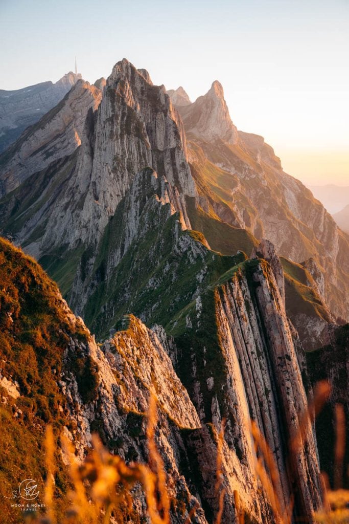
The Appenzell Alps, the northernmost mountain range of Switzerland, is defined by fanciful landscapes of limestone towers and velvet-green pastures. The rock formations are so striking that they look like the imagined backdrop of a high fantasy world.
Beyond the alluring scenery, hiking in Appenzell (Appenzellerland) is a tremendous cultural experience. Whilst hiking, you’ll experience the age-old tradition of transhumance, the seasonal practice of moving livestock from one grazing area to another. You can buy Appenzeller Käse (cheese) from mountain diaries and mountain inns, witness seasonal cattle drives, and hear Alphorn music as well as Yodeling.
Relatively compact, the Appenzell Alps are very approachable and easy to navigate. Signage and waymarking is ubiquitous. And, there’s a high concentration of mountain inns and alpine pasture huts, which means you’ll never be hungry. In fact, you’ll likely be full, stuffed, and overfed.
If you stay in one of the villages (Appenzell, Weissbad, Schwende) along the Gossau–Wasserauen line of the Appenzell Railways, you can access most trailheads with transit. We traveled without a car during our second trip and it was very easy to get around.
The Appenzell Alps are a feast for the eyes and visual nourishment for those of us who need natural beauty like we need air to breathe. Use this Appenzell hiking guide to plan a magical, fantastical, and unforgettable trip to Switzerland’s most darling region.
- When to Hike in Appenzell: May – October
- Trail Waymarking: Trails that are marked with white-red-white blazes signify moderate mountain trails while trails marked with white-blue-white blazes signify difficult alpine trails.
- What to Bring: Sun protection, sturdy hiking boots, swimming suit, reusable water bottle, and hiking poles.
- Closest Airport to Appenzell: Zurich (ZRH), Switzerland, and Memmingen (FMM), Germany
- Recommended Self-Guided Hiking Tours: 8-Day Hut to Hut in Switzerland Standard Itinerary (moderately-paced), or6-Day Hut to Hut in Switzerland Active Itinerary (faster-paced)
- Where to Stay in Appenzell Village: Alte Metzg – Hostel (budget), Blattenheimat (midrange), Hotel B&B Stossplatz (midrange), or Hotel Appenzell (luxury)
- Where to Stay in Weissbad Village: Weissbad Lodge (midrange), or Hotel Hof Weissbad (luxury)
- Where to Stay in Schwende: Hotel Frohe Aussicht (midrange)
- Recommended Trail Map: K+F 09, Appenzell, Säntis, St. Gallen 1:40.000
Appenzell Hiking Map
Where are the Appenzell Alps

The Appenzell Alps are located in northeastern Switzerland, near the borders of Liechtenstein, Austria, and Germany. The range extends across the Swiss Cantons of Appenzell Ausserrhoden, Appenzell Innerrhoden and St. Gallen.
The Appenzell Alps comprise the Alpstein massif, the Churfirsten chain, Alvier Group, and the Speer – Mattstock Group.
The Alpstein massif attracts the most visitors, because of its striking limestone towers, stunning lakes, and saddle-straddling mountain huts. The range is made up of three parallel chains, which run southwest to northeast. In between these jagged chains lie mountain lakes, alpine pastures, and many huts.
The highest mountain in the Appenzell Alps is Säntis (2502 m), followed by Girenspitz (2448 m), and Altmann (2436 m).
The Appenzell Alps are bordered by the Glarus Alps and the Rätikon Alps. Also check out the nearby Liechtenstein Panorama Trail and the Rätikon High Trail Circuit.
Appenzell Day Hikes
1. Ebenalp to Berggasthaus Aescher Hike

Berggasthaus Aescher (Äscher is the German spelling) is a mountain inn built into the rock wall of Ebenalp in the Alpstein mountains.
Photos of this 19th century, cliff-hugging, timber hut have graced the covers of multiple travel magazines, including National Geographic.
Though social media and print media have contributed to Äscher’s world-wide fame, Aescher has long been a top attraction in Switzerland, due to its proximity to the Wildkirchli caves.
In the 18th century, tourists flocked to the Alpstein to visit the Wildkirchli caves by torchlight. These caves were used by Neanderthal hunters during the summer and by hibernating bears in the winter.
Thanks to the Wasserauen-Ebenalp cable car, it’s rather easy to get to Berggasthaus Aescher. From the Ebenalp mountain station, it’s only a 25-minute hike to the cliff hut. The trail gently descends across the Ebenalp mountain pasture to the entrance of the Eremitenhöhle Wildkirchli cave.
The trail curves down the illuminated cave on a wide, sturdy path, to the cave’s exit. The descent continues along a smooth ledge trail, secured with handrails, to the Aescher mountain inn.
Alternatively, you can hike to Aescher without a cable car. From Wasserauen, hike to Lake Seealpsee and continue the ascent to Aescher.
Berggasthaus Aescher is open between May and November. You can order food and drinks throughout the day. You can also book an overnight stay in the hut.
Trail Stats
Starting Point/Ending Point | Ebenalp Cable Car Valley Station, Wasserauen
Trailhead | Ebenalp Cable Car Mountain Station
Distance | 1.2 km out-and-back
Time Needed | 1 hour
Elevation Gain/Loss | 324 meters
Difficulty | Easy
Learn More: How to Get to Berggasthaus Aescher in Switzerland
2. Ebenalp to the Schäfler Ridge Hike

A hike to Berggasthaus Aescher ought to be combined with the hike to Schäfler Ridge, possibly the most extraordinary ridge in Europe.
From the Wasserauen-Ebenalp mountain station, it only takes 1:15 hours to hike to Berggasthaus Schäfer, the mountain inn that stands atop Mount Schäfler.
Just beyond the Schäfler mountain inn, there are glorious viewpoints of the northern chain of the Alpstein and the ridge that links Schäfler with Altenalptürm.
This is an easy, straightforward hike. From Ebenalp, hike up to Berggasthaus Ebenalp and follow the wide Zisler ridge to Alp Chlus (40 minutes). From this alpine hut, the trail climbs up the eastern flank of Mount Schäfler to reach the hut (35 minutes).
Most visitors will hike this trail out-and-back. However, it’s also possible to continue along the ridge trail towards Säntis. You can either descend to Lake Seealpsee via Altenalp mountain pasture, or even Berggasthaus Mesmer.
Trail Stats
Starting Point/Ending Point | Ebenalp Cable Car Valley Station, Wasserauen
Trailhead | Ebenalp Cable Car Mountain Station
Distance | 5.5 km out-and-back
Time Needed | 2:15 hours
Elevation Gain/Loss | 372 meters
Difficulty | Easy-Moderate
Learn More: Schäfler Ridge Trail Guide
3. Lake Seealpsee Circuit Trail

Seealpse is an attractive mountain lake, surrounded by forest and mountain pastures. It’s also a popular swimming destination in summer.
There are two trails that lead from Wasserauen to Seealpse: the upper Klein-Hütten trail and the lower valley trail (farm road).
We highly recommend ascending the upper trail to Seealpsee, because this approach is far more scenic and the views unfold splendidly.
To find this trail, locate the paragliding landing area, marked by a shipping container, next to the Wasserauen car park. The path angles up across the grassy meadow and ascends through a beach forest to reach the Klein-Hütten mountain pasture.
The path gently descends across a storybook landscape to the northeastern tip of the lake.
Follow the trail that wraps around the lake to the Seealp mountain pasture.
The path continues around the lake to Berggasthaus Seealpsee and Gasthaus Forelle.
Follow the wide track in the direction of Wasserauen. At the Chobel junction, you can either hike up to Berggasthaus Aescher and Ebenalp (and then descend to Wasserauen by cable car), or continue following the road down to Wasserauen.
Trail Stats
Trailhead | Wasserauen Train Station, or Wasserauen Car Park
Distance | 7.3 km circuit
Time Needed | 2:45 hours
Elevation Gain/Loss | 372 meters
Difficulty | Easy-Moderate
Learn More: Lake Seealpsee Hiking Trails
4. Hoher Kasten – Saxer Lücke – Fälensee Hike

Saxer Lücke (1650 m) is a gap along the eastern mountain ridge of the Alpstein Mountains.
Saxer Lücke serves as a mountain pass linking the Rhine Valley with Appenzellerland. Historically, a mule track led from Sax village in the Rhine Valley over the Saxer Lücke to Brülisau village.
The most spellbinding approach to Saxer Lücke begins atop Hoher Kasten, accessible by cable car from Brülisau village.
From Hoher Kasten, follow the Geological Panorama Trail across the undulating eastern ridge to Berggasthaus Staubern and then down to Saxer Lücke (3:20 hours).
As you approach Saxer Lücke, you’ll start to see the Kreuzberge mountains, a string of eight, pearl-colored vertical spires. This vantage point of Kreuzberg is one of the most sought-after photo spots in Switzerland.
From Saxer Lücke, the trail descends to Lake Fählensee (also spelled Fälensee) and Berggasthaus Bollenwees (25 minutes).
In the beginning of this Appenzell hiking guide, I mentioned that the Alpstein is made-up of fantasy-like landscapes. Fählensee is one such landscape. This dreamy body of water is cradled by a succession of serrated peaks that look painted.
The 2-hour descent to Brülisau follows farm roads. You’ll pass Lake Sämtisersee and Berggasthaus Plattenbödeli along the way. It’s longer and more taxing (for the knees) than you’d expect.
Good to Know | You can also do an out-and-back hike to Saxer Lücke and Fählensee starting at Staubern. There’s a cable car that links Frümsen with Berggasthaus Staubern. This is the easier and shorter option, but only viable if you’re traveling with a car.
Trail Stats
Starting Point/Ending Point | Hoher Kasten Valley Station, Brülisau
Trailhead | Hoher Kasten Mountain Station
Distance | 19.3 km point-to-point
Time Needed | 6 hours
Elevation Gain | 505 meters
Elevation Loss | 1385 meters
Difficulty | Moderate – Moderately-Difficult (because of the length)
Learn More: Hoher Kasten to Saxer Lücke Hike
5. Marwees to Meglisalp Circuit Hike

Marwees is the mountain that rises up between Lake Seealpsee and the valley of Widderalp in the heart of the Alpstein massif.
The Marwees Ridge trail is one of the most rewarding and demanding hikes in the Alpstein mountains. This is our favorite day hike in the area.
It follows both white-red-white (moderate) and white-blue-white (difficult) trails. This is a suitable hike for surefooted mountain hikers who have stamina and no fear of heights. Only hike this trail in dry conditions and in stable weather.
Starting at the paragliding landing area next to the Wasserauen car park, follow the trail in the direction of Klein-Hütten (this is the same trail as Lake Seealpsee initially). At the Klein-Hütten trail junction, the Marwees hiking trail branches off to the left and ascends steadily to the Bogartenlücke mountain saddle.
From the Bogarten saddle, the way continues very steeply up a channel to the slopes of Marwees. A traverse brings you to the Marwees ridge. After a steep push to the Marwees Eastern Summit, the trail follows the narrow spine of Marwees with greater ease.
The ridge is an absolute joy to hike. You’ll see Widderalpstöck (2058 m), Hundstein (2157 m), Altmann (2435 m), Ebenalp (1640 m), Schäfler (1924 m), and many more peaks.
The path eventually skirts the highest summit of Marwees and descends to Widderalpsattel saddle, Bötzelsattel saddle, and then Meglisalp (mountain inn, mountain pasture, chapel).
After a well-deserved break at Berggasthaus Marwees, continue the descent to Lake Seealpse and then all the way down to Wasserauen.
Trail Stats
Trailhead | Wasserauen Train Station, or Wasserauen Car Park
Distance | 14.5 km circuit
Time Needed | 6:45 hours
Elevation Gain/Loss | 1225 meters
Difficulty | Difficult
Learn More: Marwees Ridge Hiking Trail
6. Lisengrat Ridge Trail

Lisengrat is the ridge that connects Mount Säntis, the highest mountain in the Alpstein, with Mount Altmann, the third highest summit in the Alpstein.
The cable-secured Lisengrat ridge trail runs between Mount Säntis and Berggasthaus Rotsteinpass, the mountain inn that stands on the Rotstein mountain pass.
To start the hike, take the Säntis cable car from Schwägalp to Mount Säntis.
Everyone has a different comfort level with narrow airy trails and exposure. For us, this trail wasn’t difficult, because of the generous placement of fixed cables. The trail is exposed, but there’s no “total” exposure. You always have something to hold onto.
To start this hike, you have to take the cable car from Schwägalp to Mount Säntis. Alternatively, you can tackle this trail along our 3-day Alpstein trek (coming soon).
The summit of Säntis is completely built-up with walkways, viewing platforms, a restaurant, tunnel system, and more. Below the summit, there’s also a mountain inn: Berggasthaus Alter Säntis.
From Berggasthaus Alter Säntis, hike down the cement stairs and cross the rocky slope beneath the covered walkway.
A series of chiseled rock stairs, flanked by cables, steeply steer you up a rock slope. After wrapping around a ledge, the trail continues across the wide, grassy ridge of Chalbersäntis.
The path gently descends, often winding around massive limestone outcrops and walls. The trail continues along an impressive ledge carved into the rock wall.
A short cabled-secured ascent brings you to the top of the ridge, where a menacing-looking staircase plummets and then rises before you. When you reach the top of the stairs, you’ll see the Rotsteinpass mountain inn, backed by the Fliswand mountain wall.
The Lisengrat trail descends more steeply now, twisting down scree. Cross the grassy ridge slopes to reach the Rotsteinpass mountain inn (2122 m).
After taking a rejuvenating break at Rotsteinpass mountain hut, return to Mount Säntis along the same trail.
Trail Stats
Starting Point/Ending Point | Säntis Cable Car Valley Station, Schwägalp
Trailhead | Säntis Cable Car Mountain Station
Distance | 5.1 km out-and-back
Time Needed | 2:30 hours
Elevation Gain/Loss | 400 meters
Difficulty | Moderately Difficult
Learn More: Lisengrat Ridge Trail Guide
Appenzell Treks
7. Alpstein High Trail: 3-Day Hut-to-Hut Hike

This 3-day Alpstein high trail trek runs along the high trails of the Alpstein mountains, starting in Wasserauen and ending in Brülisau (Hoher Kasten). You can navigate to the starting point and from the ending point easily with public transit.
This U-shaped route links together the most striking landscapes and attractions of the Alpstein massif, including Lake Seealpsee, the Aescher mountain inn, Ebenalp, the Schäfler ridge, the Altenalp Towers, Mount Säntis, Lisengrat ridge, the Rotsteinpass mountain inn, the Zwinglipass Hut, the Saxer Lücke saddle, the Kreuzberge viewpoints, Stauern mountain inn, and the Hoher Kasten summit.
Exclusively following white-red-white trails, this 33-km alpine hike is a great option for surefooted, fit mountain hikers who enjoy ridge paths and limestone terrain (uneven surface, scree, loose rocks, etc…).
It’s a moderately difficult route, which requires a head for heights and stamina. All exposed areas are well-secured with aids (fixed cables, rungs, etc…). No special equipment is needed aside from sturdy hiking boots and hiking poles. We recommend the Unisex Black Diamond Hiking Poles.
Alpstein Trek Overview
Stage 1: Wasserauen to Berggasthaus Schäfler (9.9 km, 5 hours, 1346 meters elevation gain, 307 meters elevation loss).
Stage 2: Berggasthaus Schäfler to Zwinglipasshütte SAC (10.6 km, 6 hours, 956 meters elevation gain, 882 meters elevation loss).
Stage 3: Zwinglipasshütte SAC to Hoher Kasten (13 km, 5 hours, 703 meters elevation gain, 917 meters elevation loss)
Learn More: 3-Day Alpstein High Trail
8. 8-Day Appenzell Alps Hut to Hut Hike

This 8-day hut-to-hut hike, offered exclusively by Alpenventures UNGUIDED, is a self-guided hiking tour of the Alpstein.
The 70-km route zigzags across the Appenzell Alps, taking in the most famous landmarks, trails, and huts along the way, including Lake Fälensee, the Geological Panorama Trail (Saxer Lücke to Hoher Kasten), the Schäfler Ridge, Heaven’s Ladder, and more.
Highlights of this hut-to-hut trail are staying in the cliffside Aescher hut, the ridge-straddling Tierwies hut, and the lakeside Bollenwees hut.
You can book this moderately-paced 8-Day Hut to Hut in Switzerland Standard Itinerary or this faster-paced 6-Day Hut to Hut in Switzerland Active Itinerary.
9. Swiss Whiskey Trek

The 8-Day Swiss Whiskey Trek is a thematic hut-to-hut hiking trail in the Appenzell Alps for Whiskey connoisseurs.
Along the route, hikers can sample unique whiskeys, which are aged in barrels located at or near the mountain huts. Each whiskey has a distinct flavor and color due to the type of barrel (American, Portuguese, French, or Russian Oak) and previous occupancy (sweet wine, Merlot, Gamay, Zweigelt, port, sherry, rum, plum brandy, etc…)
After completing the hut-to-hut hike, hikers are treated to a complimentary gift packet, which includes 1 bottle of whiskey, a bottle of beer, and a whiskey glass.
Book this self-guided tour: Swiss Whiskey Trek
10. Easy 6-Day Appenzell Hut to Hut Trail

Are you new to hut-to-hut hiking? Are you planning a trip with your adult parents, or with your children?
This easy 6-Day Appenzell Trek takes in the beauty of the Appenzell mountains, but bypasses all challenging terrain.
This carefully-crafted itinerary is 32-km long and steers hikers across the Appenzell Alps along easy-moderate hiking trails with minimal technical difficulty.
Learn more: Hut to Hut Light in Switzerland Relaxed Itinerary.
Best Base for Hiking in the Appenzell Alps
Appenzell Village

The lovely town of Appenzell is the capital of the Swiss Canton of Appenzell Innerrhoden. Surrounded by beautiful countryside, Appenzell is a picturesque town with colorful gabled buildings that house delicious bakeries, restaurants, hotels, apartments, and museums.
Accommodations are always clean and comfortable, but modest. There are no 5-star hotels in this area of Switzerland.
We recommend staying in, or near the village center of Appenzell, because of the dining options and cultural activities (museums and art galleries). After long hikes in the Alpstein, it’s ever so nice to end your day in the heart of Appenzellerland.
Appenzell is also a great base for those traveling without a car. With train connections to Wasserauen and Weissbad (bus transfer to Brüllisau), it’s effortless to get around to various trailheads.
Budget | Alte Metzg – Hostel offers 3 spotless rooms with communal bathrooms and kitchen facilities. This intimate hostel is walking distance to the Appenzell village center and train station. On-site parking is available, but must be reserved in advance (fees apply). They also run the neighboring midrange Alte Metzg Boutique Pension with private single, double, and family rooms.
Midrange | Blattenheimat – im traditionellen Appenzeller Haus (2 nights minimum stay) is a traditional, gabled house with 2-3 bedroom apartments and free private parking, very close to the Hauptgasse (pedestrain main street of Appenzell). Guests have access to a washing machine and dryer in the basement.
Midrange | Located very close to the Appenzell train station, Hotel B&B Stossplatz is a darling bed and breakfast with free private parking, free bikes, and a shared lounge. Rooms either have shared, or private bathrooms.
Luxury | Hotel Appenzell is located on the historic Landgemeinde Square in the center of Appenzell village. Boasting an excellent restaurant with an outdoor terrace as well as a confiserie (patisserie), this traditional Appenzell hotel is a great option for your stay. Breakfast and parking are included in the rate.
Luxury | Adler Hotel is centrally located at the start of the pedestrian Hauptgasse (main street), across from the Parish Church of St. Mauritius and the Metzibrücke Bridge. This traditional hotel with two restaurants is a great place to stay if you’re traveling without a car. No parking available on-site.
Look for accommodation in Appenzell.
Weissbad Village
Weissbad is a quiet village in Schwendetal Valley between Appenzell and Wasserauen.
Situated on the Gossau–Wasserauen train line of the Appenzell Railways, Weissbad is a great base for exploring the region. It takes a mere 6 minutes to reach Appenzell village by train. It takes only 10 minutes to ride the train to Wasserauen (Ebenalp cable car valley station, Seealpsee trailhead, Marwees trailhead, etc…). And, it’s only an 8-minute bus ride to Brüllisau (Hoher Kasten cable car, Saxer Lücke and Fählensee trailhead).
Midrange | Weissbad Lodge, not to be confused with the nearby sister property of Hotel Hof Weissbad (luxury), is a comfortable accommodation with spacious, modern rooms and free on-site parking. The lodge is located on the bank of the Sitter River, just a block away from the Weissbad train station and bus stop. The only negative is the self-service breakfast.
Luxury | Hotel Hof Weissbad accommodates luxury-minded travelers with its two restaurants and bar, two swimming pools, fitness center, spa and wellness area. Breakfast and parking are included in the room rate. The price is rather steep.
Look for accommodation in Weissbad.
Schwende Village
Schwende lies in Schwendetal Valley, just south of Weissbad.
This village is also located along the Gossau–Wasserauen train line, with direct connections to Wasserauen, Weissbad, and Appenzell.
Midrange | The family-run Hotel Frohe Aussicht, which means “happy outlook,” is a hillside hotel and restaurant surrounded by beautiful countryside. It’s a short uphill walk from the Schwende train station to the hotel. Guests love the views and the restaurant!!!

Alps Trip Planning Essentials
When to Visit the Alps
We recommend visiting the Alps in summer (June – mid September), fall (mid September – late October) or winter (late December – March).
Read Alps in Summer to learn everything you need to know about visiting the Alps between June and mid/late September.
Alps Road Trips
Most destinations in the Alps are accessible by transit. If you’re visiting during peak seasons, we recommend traveling with trains and buses.
If you’re visiting during shoulder seasons (late May, early June, late September, October), a car is often essential in getting around.
When we go on hut-to-hut hikes, we always travel with transit. When we want to do a lot of day hikes, we find it easier to travel with a car.
We recommend using the Discovercars.com car rental reservation platform to search for and book car rentals. This easy-to-use booking platform compares car rental deals from 500+ trusted providers, so that you can choose the best option for your trip.
Alps Road Trip Itineraries
- Italian Alps: 5 Day Dolomites Road Trip
- Italian Alps: 7 Day Dolomites Road Trip
- Italian Alps: 10-14 Day Dolomites Road Trip
- Bavarian Alps and Tyrolean Alps: 10-Day Bavaria and Tyrol Road Trip
- Austrian Alps: 2-Week Austria Road Trip
- Austrian Alps: 1 Week Austria Road Trip
- Slovenian Alps: 2-Week Slovenia Road Trip
- Slovenian Alps: 5-Day Slovenia Road Trip
Alps Hiking Guides
Hiking in the Alps is our passion.
To learn about when to hike, where to hike, and hiking safety, read: Hiking in the Alps: Essential Tips. For trail inspiration, check out Best Hikes in the Alps.
For region specific trail inspiration, read:
- Bavarian Alps: Best Hikes in Garmisch-Partenkirchen
- Italian Alps: Best Day Hikes in the Dolomites
- Austrian Alps: Best Day Hikes in Austria
- Slovenian Alps: Best Hikes in Slovenia
Alps Hiking Essentials
- Day Pack: Osprey Tempest 30 Women’s Backpack / Osprey Talon 33 Men’s Backpack
- Grade B/C high-cut hiking boots: Meindl Schuhe Island Lady (Kati’s Boots), Women’s Hanwag Tatra II GTX (Sabrina’s Boots), Men’s Hanwag Tatra II GTX (men’s equivalent)
- CAT 4 Sunglasses: Julbo Shield Mountain Sunglasses
- Hiking Poles: Black Diamond Trail Trekking Poles
- Backpack Camera Clip: Peak Design Camera Clip
Pin this Image for Future Trip Planning!
Stay Connected:
Connect with us on Pinterest.
Follow us on Instagram.
Like us on Facebook.
Support Us:
If you love reading our content, you can buy us a coffee via Ko-Fi.
