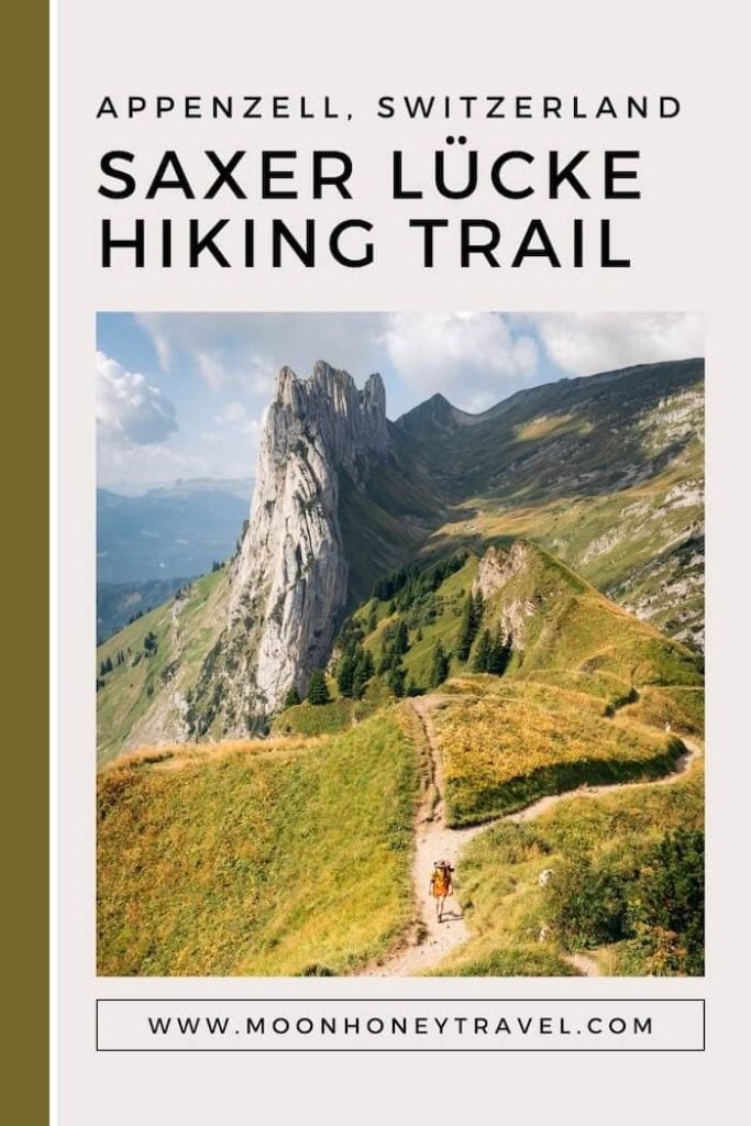
Saxer Lücke is a gap along the eastern ridge of the Alpstein Mountains in Switzerland. It lies on the border between the Swiss Cantons of St. Gallen and Appenzell Innerrhoden.
The Saxer Lücke gap (1650 m) serves as a mountain pass linking the Rhine Valley with Appenzellerland. In former times, a mule track led from Sax village in the Rhine Valley over Saxer Lücke to Brülisau village.
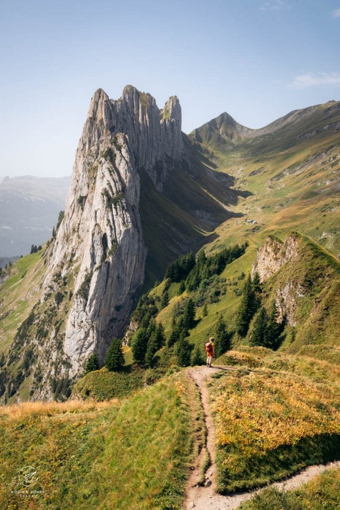
Why is a “mountain pass” so famous? The reason Saxer Lücke is a much sought-after hiking and photography destination is because it lies beneath the Kreuzberg chain, a string of eight, pearl-colored vertical spires. These peaks range from 1884 meters to 2063 meters above sea level.
When you approach Saxer Lücke from the northeast (e.g. Hoher Kasten and Staubern), the views of the Kreuzberg Peaks are impossibly sublime. From this vantage point, the Kreuzberg (aka Chrüzberg) pinnacles look like the lip of a tsunami wave.
There are a few ways to hike to Saxer Lücke. If you’re based in, or around Appenzell village and traveling without a car, we recommend starting the hike in Brülisau village with the Hoher Kasten cableway ascent.
From the Hoher Kasten mountain station, follow the rolling ridge to Berggasthaus Staubern and onwards to Saxer Lücke. From the Saxer Lücke saddle, descend to the Berggasthaus Bollenwees hut at Lake Fählensee (also spelled Fälensee).
From the lakeside hut, continue the hike down to Lake Sämitersee and ultimately all the way back down to Brülisau village.
Below, you’ll find a detailed description of the Brülisau – Hoher Kasten – Berggasthaus Staubern – Saxer Lücke – Berggasthaus Bollenwees – Fählensee (Fälensee) – Sämtisersee – Brülisau circuit trail.
Don’t forget to bring your bathing suit, because you can swim in both Fälensee and Sämtisersee.
- Starting Point/Ending Point: Brülisau Village | Google Maps
- Trailhead: Hoher Kasten Mountain Station
- Distance: 19.3 km point-to-point (circuit with cable car ascent)
- Time Needed: 6 hours with detour to Fählenalp. It took us 7 hours total with a lunch break, swimming break, and various stops along the way.
- Elevation Gain: 505 meters
- Elevation Loss: 1385 meters
- Difficulty: Moderate – Moderately Difficult
- Minimum Elevation: 924 meters
- Maximum Elevation: 1817 meters
- Route: Brülisau – Hoher Kasten – Berggasthaus Staubern – Saxer Lücke – Berggasthaus Bollenwees – Fählensee (Fälensee) – Sämtisersee – Brülisau
- Where to Stay in Brülisau: Gasthaus Rössli (midrange)
- Where to Stay in Appenzell Village: Alte Metzg – Hostel (budget), Blattenheimat (midrange), Hotel B&B Stossplatz (midrange), or Hotel Appenzell (luxury)
- Where to Stay in Weissbad Village: Weissbad Lodge (midrange), or Hotel Hof Weissbad (luxury)
- Recommended Trail Map: K+F 09, Appenzell, Säntis, St. Gallen 1:40.000
Hoher Kasten – Saxer Lücke Hiking Map
Hoher Kasten – Saxer Lücke – Fälensee Hiking Trail Difficulty

The Saxer Lücke circuit hike is a moderate day hike in the Alpstein. It exclusively follows white-red-white hiking trails.
In terms of navigation, this is a very easy trail to follow. The route is waymarked with white-red-white blazes and there are trail signs at all junctions.
There is no technical difficulty. However, there are some rugged stretches of trail. So, expect uneven rocky terrain and wear sturdy hiking boots. Sections of the ridge are further bolstered with metal and timber steps and fixed cables.
The length of the trail and the total elevation loss is what makes this a hefty hiking excursion in the Appenzell Alps.
We’ve hiked the Hoher Kaste-Saxer Lücke trail twice and on each occasion we were awestruck by the views, but also quite tired at the end. The long descent is taxing on the knees.
Though it would seem that the trail is only downhill, it isn’t. As you journey along the Eastern Ridge of the Alpstein between Hoher Kasten and Saxer Lücke, you’ll have to conquer 430 meters of elevation gain.
When Can You Hike to Saxer Lücke

The Hoher Kasten – Saxer Lücke Geological Trail is usually open between May and mid-November, depending on snow conditions.
Current trail conditions are summarized on hoherkasten.ch.
How to Get to Saxer Lücke
Brülisau-Hoher Kasten Cable Car

The Hoher Kasten to Saxer Lücke hike starts and ends in the village of Brülisau, a 10 minute drive from the town of Appenzell.
There are two paid car parks in Brülisau. You can pay the parking fee using a mobile app (easypark or parkingpay), or with CHF coins.
Brülisau is also easily accessible by transit. If you’re based in Appenzell, Schwende, Wasserauen, or Steinegg, take the regional train to Weissbad. From Weissbad, take a direct bus to Brülisau.
Tip | If you stay in the Appenzell region for 3, or more nights, you will receive a “Appenzeller Ferienkarte,” which not only gives you free transit on regional buses and trains, but also a free ride (one-way, or return) on the Hoher Kasten Cableway.
Purchase a one-way ticket to Hoher Kasten. If you have an “Appenzeller Ferienkarte,” you can simply scan your “Appenzeller Ferienkarte” QR code.
The Hoher Kasten cable car ride takes 10 minutes. It runs every 20 minutes (xx:00 / xx:20 / xx:40).
Hoher Kasten Cable Car Info | hoherkasten.ch
Frümsen-Staubern Cable Car
Alternatively, you can hike to Saxer Lücke from Berggasthaus Staubern, accessible via the 8-person Frümsen-Staubern Cable Car.
The Staubern Cable Car valley station is located in the village of Frümsen in the Rhine Valley in St. Gallen.
Berggasthaus Staubern is located on the ridge between Hoher Kasten and Saxer Lücke.
This is the shortest way to get to the various Saxer Lücke viewpoints.
This is definitely an option for people traveling with a car and with limited time. If you choose this option, you can hike from Berggasthaus Staubern to Saxer Lücke out-and-back. You can easily extend the hike to Lake Fählensee.
Frümsen-Staubern Operating Times and Prices | appenzell.ch
Hoher Kasten – Berggasthaus Staubern – Saxer Lücke – Lake Fählensee – Lake Sämtisersee – Brülisau Trail Description
Hoher Kasten Summit Station

Hoher Kasten is a 1794-meter-high mountain in the Alpstein, accessible by cableway from Brülisau village in Appenzell Innerrhoden.
The Hoher Kasten mountain summit is a highly built-up area with various viewing platforms, a barrier-free walkway, and a weather station. The cable car mountain station comprises a cafeteria, revolving restaurant, shop, and restrooms.
Many people simply ride up to Hoher Kasten for lunch, accompanied by panoramic views of the Rhine Valley, Liechtenstein, Austria, Germany, and Eastern Switzerland.
Before starting the hike, take in the sweeping views of the Alpstein mountain range from the viewing platforms.
You can already see the trail to Saxer Lücke.
The route follows the eastern ridge of the Alpstein to Berggasthaus Staubern, the mountain hut that stands on the Stauberngrat ridge beneath Staubernkanzel. Just beyond the rocky Staubernkanzel peak, you can also see the jagged spires of Kreuzberg.
Cradled between the eastern ridge and Alp Sigel lies Lake Sämitersee.
This camel-back-like eastern ridge of the Alpstein marks the border between the cantons of Appenzell Innerrhoden and St. Gallen.
Hoher Kasten – Kastensattel – Wenneli (45 minutes)

This trail is officially called the “Geologischer Wandwerweg,” which simply means the Geological Trail. Along the trail, there are info boards (German only) that explain the geography of the landscapes.
Locate the stacked yellow trail signs near the exit of the Hoher Kasten mountain station. Stauberen is signed 2:10 hours and Bollenwees is signed 3:50 hours.
Walk down the concrete steps and continue along the gravel path, signed “Bergwanderweg.” With views of the Rhine Valley, the trail descends in switchbacks down the northeastern flank of the mountain.
After squeezing around a metal gate, the trail divides. Take the right, lower path to the Kastensattel mountain saddle trail junction (1678 m).
Turn left in the direction of Stauberen, signed 2 hours.
The Saxer Lücke-bound trail leads in a southwesterly direction, crossing beneath the Hoher Kasten rock wall. On your right, rolling farmland unfurls between green, forested hills.
After descending through a patch of forest, views open up to Lake Sämitersee and the Alpstein mountains.

The trail continues along the spine. On the Rhine-Valley-side of the ridge, the slope is riddled with avalanche snow bridges.
This spine-clinging path drops down to a minor saddle (Rorsattel, 1590 m), before a rocky pinnacle. The Alp Rohr / Sennwald trail bears left. Our Staubern – Bollenwees trail swings to the right and curves down, tracing the base of the rock wall.

The trail descends to the Wenneli (1534 m) junction, a low point along the ridge. Continue in the direction of Stauberen, now signed (1:25 hours).
Wenneli to Berggasthaus Staubern (1:25 hours)

Up until now, the trail has predominantly angled downhill.
Starting at Wenneli, the trail ascends for the first time. It’s not a significant, or particularly steep ascent, but it’s a surprise (when you’ve been comfortably hiking downhill for some time).
Wind up the forest. After about 10 minutes, the trail crests the main ridge and the path soon eases. The trail continues either directly on, or just beneath the main spine.
Once again, you’ll see sweeping views of the Rhine Valley. The mountains on the other side of the Rhine River form part of the Rätikon, a stunning mountain range that stretches across Liechtenstein, Austria, and Switzerland. If you’re interested in learning more about nearby hiking trails, read Liechtenstein Panorama Trail and Rätikon Alps High Trail Circuit.
The raspberry-lined trail descends into a mixed forest. On a hot day, the shade is a godsend. The path is secured with fixed cables in some places.
After a pleasant, level stretch, the trail ascends again (160 meters elevation gain to Berggasthaus Staubern).

The trail, reinforced with metal steps, twists up the forested spine. Alternating between uphill and flat passages, the undulating ascent continues for about 30 minutes.
Eventually, the trail crests the Stauberngrat ridge and glides to Berggasthaus Staubern. Sheep graze along the trail in summer.
Berggasthaus Staubern stands on the ridge, at the foot of the Stauberenkanzel (Staubernkanzel) peak.

Just below the hut, you’ll see the Frümsen-Staubern Cable Car mountain station.
Berggasthaus Staubern (1751 m) is an excellent place to eat lunch. However, so is Berggasthaus Bollenwees at Lake Fälensee. It’s a difficult decision to make.
We ate at Berggasthaus Staubern on the last stage of our 3-day Alpstein High Trail trek and it was delicious! We ordered the goat cheese salad and of course a Rösti.
Berggasthaus Staubern to Saxer Lücke (1:10 hours)

The hike from Staubern to Saxer Lücke unfolds beautifully, with enrapturing views of the Kreuzberg peaks and bird’s-eye views of Lake Fählensee (Fälensee).
The trail continues behind the hut.
Cross the slope of Stauberenkanzel.
A few timber steps bring you to a crevice. Pass through and descend amid sparse pine. You will be able to see Lake Fählensee for the first time.
The path, now more rugged, descends. Hike down the metal staircase and wrap around the secured ledge.

The traverse continues across slopes, far below the main crest.
A final ascending passage, up rougher terrain, brings you to a panoramic path, moving ever closer to Hüser Peak

The path levels and it’s easy, fat walking for quite a long time.
On the right, there’s a falling ridge, which serves as a nice photo spot of Lake Fälensee, a glistening blue pool at the foot of soaring saw-toothed peaks.

Hochhus Peak looms above the trail.
The traverse continues, bringing you once again to the ridge. As you draw closer to Saxer Lücke, the Kreuzberg peaks upstage everything else.
The path twists along the grassy spine of the Alpstein’s eastern ridge.
There are many viewpoints and photo opportunities of Kreuzberge along the crest.

The eight spires of Kreuzberg look like a single mass looming over a vast silken sea. Behind Kreuzberg, you can see Mutschen, the triangle-shaped peak above the Mutschen-Sattel. The Mutschen saddle is the gateway to the Chreialpfirst ridge and the Zwinglipasshütte SAC.
The smooth rounded mountain to the right (northwest) of Kreuzberg is Roslenfirst (Roslen-Saxer First), 2151 m. Between Kreuzberg and Roslenfirst, lies the Roslenalphütte.

To reach one “Instagram famous” viewpoint, you have to climb up to a minor grassy summit, along the ridge. This vantage point overlooks the Saxer Lücke gap. Only hike up this steep path in dry conditions.

Well-graded serpentines steer you down to the Saxer Lücke saddle. Every turn affords new, spectacular views of the Kreuzberge peaks and Saxer Lücke. Savor each step.
Saxer Lücke to Berggasthaus Bollenwees and Lake Fälensee (25 minutes)

Many trails merge at Saxer Lücke, including the trails from Mutschensattel (Alpstein High Trail Stage 3) and the Rhine Valley.
Turn right and descend to Bergasthaus Bollenwees. The path descends in serpentines down to the hut.
Optional: Berggasthaus Bollenwees to Fälenalp (50 minutes out-and-back)

With its awe-inspiring lake views, Berggasthaus Bollenwees is the ultimate destination for lunch along the Saxer Lücke trail. Take a well-deserved rest here, before continuing the hike. Bollenwees is famous for their Rösti with Appenzeller Käse and Speck.
On the opposite side of the lake there’s an alpine pasture, Fählenalp (Fälenalp), home to a herd of Appenzell goats. It’s an enjoyable walk along the lakeshore to the Alp, but it does add a good 50-60 minutes to the hike.

You can purchase goat cheese and other dairy products from the Alp.
Berggasthaus Bollenwees – Tannhütte – Lake Sämtisersee – Berggasthaus Plattenbödeli (1 hour)

There are two trails that fan out from Lake Fählensee in the direction of Lake Sämtisersee.
The most direct route is the obvious trail that starts at Berggasthaus Bollenwees and leads east in the direction of Furgglenalp.
Follow the gravel farm road away from the lake. At the junction, veer left.
With views of Marwees and the Dreifaltigkeit triad, the road loops down and bisects a spruce forest.
After about 30 minutes from Bollenwees, you’ll see Lake Sämtisersee. Hoher Kasten, with its weather station, is ever conspicuous in the background.
Soon after passing Tannhütte, our trail merges with the Alp Rheintaler Sämtis access road.

Continue towards the lake.
The road runs parallel to the lakeshore, but at an elevation.
You’ll ascend a few meters through forest to reach the Berggasthaus Plattenbödeli hut. This uphill stretch feels somewhat surprising.
Berggasthaus Plattenbödeli – Pfannenstiel Car Park – Alp Sigel Valley Station – Brülisau (1 hour)

From the Plattenbödeli mountain inn, the road drops steeply downhill along the Brüelbach stream to the Pfannenstiel car park. This is the most excruciating part of the hike.
There’s a trail that bypasses the steepest part of the road. Take the trail; it’s easier than the road.
At this point, your knees will probably start to hurt and you’ll fantasize about sliding down the road (or possibly not, if you’re younger, or stronger).
Anyway, when you get to the Pfannenstiel car park, the hardest part is over.
Follow the flat paved road for 1.3 km to Brülisau village, passing the Alp Sigel valley station along the way.

Walking the Pfannestielstrasse road is rather enjoyable, because of the idyllic countryside views of rolling farmland and traditional farmhouses.
This rarely-trafficked road brings you directly to the Hoher Kasten valley station and the Brülisau bus stop.
Where to Stay near Saxer Lücke
Brülisau
Brülisau is a small rural village at the foot of Hoher Kasten.
You can access the Alpstein via the Hoher Kasten cable car, Alp Sigel cable car, and Pfannenstielstrasse road, the gateway to Lake Sämtisersee and Lake Fählensee.
Brülisau is a short bus ride away from Weissbad and the Gossau–Wasserauen train line.
Midrange | Gasthaus Rössli is a top-rated guesthouse with an on-site restaurant.
Guests love the food, hospitality, quiet location, and convenient parking.
Look for accommodation in Brülisau.
Appenzell Village

The lovely town of Appenzell is the capital of the Swiss Canton of Appenzell Innerrhoden. Surrounded by beautiful countryside, Appenzell is a picturesque town with colorful gabled buildings that house delicious bakeries, restaurants, hotels, apartments, and museums.
Accommodations are always clean and comfortable, but modest. There are no 5-star hotels in this area of Switzerland.
We recommend staying in, or near the village center of Appenzell, because of the dining options and cultural activities (museums and art galleries). After long hikes in the Alpstein, it’s ever so nice to end your day in the heart of Appenzellerland.
Appenzell is also a great base for those traveling without a car. With train connections to Wasserauen and Weissbad (bus transfer to Brüllisau), it’s effortless to get around to various trailheads.
Budget | Alte Metzg – Hostel offers 3 spotless rooms with communal bathrooms and kitchen facilities. This intimate hostel is walking distance to the Appenzell village center and train station. On-site parking is available, but must be reserved in advance (fees apply). They also run the neighboring midrange Alte Metzg Boutique Pension with private single, double, and family rooms.
Midrange | Blattenheimat – im traditionellen Appenzeller Haus (2 nights minimum stay) is a traditional, gabled house with 2-3 bedroom apartments and free private parking, very close to the Hauptgasse (pedestrain main street of Appenzell). Guests have access to a washing machine and dryer in the basement.
Midrange | Located very close to the Appenzell train station, Hotel B&B Stossplatz is a darling bed and breakfast with free private parking, free bikes, and a shared lounge. Rooms either have shared, or private bathrooms.
Luxury | Hotel Appenzell is located on the historic Landgemeinde Square in the center of Appenzell village. Boasting an excellent restaurant with an outdoor terrace as well as a confiserie (patisserie), this traditional Appenzell hotel is a great option for your stay. Breakfast and parking are included in the rate.
Luxury | Adler Hotel is centrally located at the start of the pedestrian Hauptgasse (main street), across from the Parish Church of St. Mauritius and the Metzibrücke Bridge. This traditional hotel with two restaurants is a great place to stay if you’re traveling without a car. No parking available on-site.
Look for accommodation in Appenzell.
Weissbad Village
Weissbad is a quiet village in Schwendetal Valley between Appenzell and Wasserauen.
Situated on the Gossau–Wasserauen train line of the Appenzell Railways, Weissbad is a great base for exploring the region. It takes a mere 6 minutes to reach Appenzell village by train. It takes only 10 minutes to ride the train to Wasserauen (Ebenalp cable car valley station, Seealpsee trailhead, Marwees trailhead, etc…). And, it’s only an 8-minute bus ride to Brüllisau (Hoher Kasten cable car, Saxer Lücke and Fählensee trailhead).
Midrange | Weissbad Lodge, not to be confused with the nearby sister property of Hotel Hof Weissbad (luxury), is a comfortable accommodation with spacious, modern rooms and free on-site parking. The lodge is located on the bank of the Sitter River, just a block away from the Weissbad train station and bus stop. The only negative is the self-service breakfast.
Luxury | Hotel Hof Weissbad accommodates luxury-minded travelers with its two restaurants and bar, two swimming pools, fitness center, spa and wellness area. Breakfast and parking are included in the room rate. The price is rather steep.
Look for accommodation in Weissbad.
Schwende Village
Schwende lies in Schwendetal Valley, just south of Weissbad.
This village is also located along the Gossau–Wasserauen train line, with direct connections to Wasserauen, Weissbad, and Appenzell.
Midrange | The family-run Hotel Frohe Aussicht, which means “happy outlook,” is a hillside hotel and restaurant surrounded by beautiful countryside. It’s a short uphill walk from the Schwende train station to the hotel. Guests love the views and the restaurant!!!

Keep Reading about the Appenzell Alps
Travel:
Hiking:
- Best Hikes in Appenzell
- Schäfler Ridge Trail
- Marwees Ridge Trail
- Berggasthaus Aescher: Cliff Restaurant
- Lisengrat Ridge Trail
- Seealpsee Hikes
Trekking:
Self-Guided Hut-to-Hut Hiking Tours:
- Swiss Whiskey Trek
- 8-Day Hut to Hut in Appenzell Alps Standard Itinerary
- 6-Day Hut to Hut in Appenzell Alps Active Itinerary
- 6-Day Easy Appenzell Alps Relaxed Itinerary
Alps Trip Planning Essentials
When to Visit the Alps
We recommend visiting the Alps in summer (June – mid September), fall (mid September – late October) or winter (late December – March).
Read Alps in Summer to learn everything you need to know about visiting the Alps between June and mid/late September.
Alps Road Trips
Most destinations in the Alps are accessible by transit. If you’re visiting during peak seasons, we recommend traveling with trains and buses.
If you’re visiting during shoulder seasons (late May, early June, late September, October), a car is often essential in getting around.
When we go on hut-to-hut hikes, we always travel with transit. When we want to do a lot of day hikes, we find it easier to travel with a car.
We recommend using the Discovercars.com car rental reservation platform to search for and book car rentals. This easy-to-use booking platform compares car rental deals from 500+ trusted providers, so that you can choose the best option for your trip.
Alps Road Trip Itineraries
- Italian Alps: 5 Day Dolomites Road Trip
- Italian Alps: 7 Day Dolomites Road Trip
- Italian Alps: 10-14 Day Dolomites Road Trip
- Bavarian Alps and Tyrolean Alps: 10-Day Bavaria and Tyrol Road Trip
- Austrian Alps: 2-Week Austria Road Trip
- Austrian Alps: 1 Week Austria Road Trip
- Slovenian Alps: 2-Week Slovenia Road Trip
- Slovenian Alps: 5-Day Slovenia Road Trip
Alps Hiking Guides
Hiking in the Alps is our passion.
To learn about when to hike, where to hike, and hiking safety, read: Hiking in the Alps: Essential Tips. For trail inspiration, check out Best Hikes in the Alps.
For region specific trail inspiration, read:
- Bavarian Alps: Best Hikes in Garmisch-Partenkirchen
- Italian Alps: Best Day Hikes in the Dolomites
- Austrian Alps: Best Day Hikes in Austria
- Slovenian Alps: Best Hikes in Slovenia
Pin this Image for Future Trip Planning!
Stay Connected:
Connect with us on Pinterest.
Follow us on Instagram.
Like us on Facebook.
Support Us:
If you love reading our content, you can buy us a coffee via Ko-Fi.
