The Adolf Munkel Trail is a hiking path that runs along the northern foot of the Geisler/Odle Group in Val di Funes (Villnösstal) in South Tyrol, Italy. This Dolomites hiking trail is called Sentiero Adolf Munkel and Via delle Odle in Italian and Adolf Munkel Weg in German.
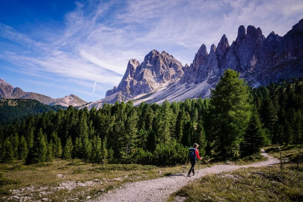
Dramatic, varied, and unforgettable, the Adolf Munkel Trail weaves its way through forest and alpine meadows, reaching a zenith at Malga Casanago/Gschnagenhardt Alm and Rifugio Odle/Geisler Alm.
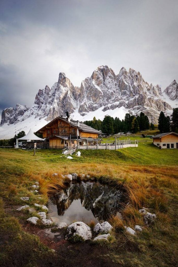
From these fairytale-like alpine pastures, the sawtooth Odle/Geisler peaks rise up like daggers slashing the sky. The Dolomites are full of dramatic places that look like they’ve been torn from pages of a fantasy epic, and this is one of them.
While this hike is an ode to the Geisler Group, it’s also an opportunity to savor the alpine pasture culture of the Dolomites. There are three opportunities to eat, drink, and be merry along the route and we hope you indulge.

- Trailhead: Zannes/Zans Car Park in Val di Funes, South Tyrol | Google Maps
- Distance: 9.2 km circuit
- Time Needed: 3 – 3:30 hours
- Elevation Gain/Loss: 378 meters
- Difficulty: Easy – Moderate
- Minimum Elevation: 1657 meters
- Maximum Elevation: 2035 meters
- Trails: 36, 35, 6
- Route: Zannes/Zans (1680 m) – Dusler Alm (1782 m) – Rifugio Odle/Geisler Alm (1996 m) – Malga Casanago/Gschnagenhardt Alm (2006 m) – Zannes/Zans (1680 m)
- Where to Eat: Dusler Alm, Geisler Alm, or Gschnagenhardt Alm
- Where to Stay in Val di Funes: Appartements Pension Sonia (budget), Fallerhof (budget), Hotel Fines (midrange) or Hotel Tyrol (luxury)
- Recommended Trail Map: Tabacco 030 Bressanone – Val di Funes
Adolf Munkel Trail Map
When Can You Hike the Adolf Munkel Trail

It’s possible to hike the Adolf Munkel Trail from early June until mid/late October, depending on snow conditions.
Given the popularity of this trail, we recommend hiking early, or late in the Dolomites hiking season.
October is an ideal month to hike the Adolf Munkel Trail.
Best Time of Day to Hike the Adolf Munkel Trail
We recommend starting this hike 4 hours before sunset. The Odle/Geisler peaks are illuminated by the sun at the end of the day.
What is the Adolf Munkel Weg

Adolf Munkel was the founder and section chairman of the Dresden Alpine Club for 30 years. The popular hiking trail at the foot of the Geisler peaks was created in 1905 thanks to the commitment of the Dresden Alpine Club. The path was named in honor of the meritorious founder Adolf Munkel.
The Adolf Munkel Trail is a 9.2 km path that stretches between Rifugio Malga Brogles (2045 m, Schutzhaus Brogles-Alm) and Rifugio Genova (2306 m, Schlüterhütte) along the northern base of the Odle Group.
Because neither Rifugio Brogles nor Rifugio Genova are accessible by car, or by bus, the best way to access the Adolf Munkel Trail is from the Zannes/Zans trailhead at the end of the Val di Funes valley road.
If you’re staying in Ortisei in Val Gardena, you can also access the Adolf Munkel Trail from the Resciesa Plateau. Take a look at this Resciesa – Malga Brogles – Seceda trail guide.
Which Direction to Hike the Adolf Munkel Trail

There are a few variations of the Adolf Munkel Trail, with the most common route starting in Zannes/Zans.
When we first hiked the Adolf Munkel Trail a few years ago, we walked clockwise (the popular direction) from Zannes/Zans, starting on trail 6 and ending on traiI 36. I remember promising myself that if I ever hiked it again, I’d do it in reverse.
The reason is that if you hike clockwise, you won’t be facing the Odle/Geisler Peaks along the most memorable part of the Adolf Munkel Trail. So, when we hiked the trail again in October, we hiked counter-clockwise. It does feel like you’re going against the current, but I think it’s worth it.
Other variations of the Adolf Munkel Trail begin in Ranui in Val di Funes. From Ranui, follow trail 28 to Rifugio Brogles/Brogles Hütte.
Next, continue along the Adolf Munkel Trail (#35) to Malga Casanago/Gschnagenhardt Alm and then complete the circuit to Ranui via Trail 34.
Zannes / Zans Car Park Trailhead
Read How to Visit Val di Funes for driving and transit directions to Val di Funes.
Continue driving to the head of the valley until you arrive at Zannes/Zans (1680 m).
There are three parking lots at Zannes. Pay the parking fee at the booth and park wherever there’s room.
Though likely not a necessity, you can pre-book your parking on villnoess.com.
Zannes Car Park Location | Google Maps
Zannes Car Park Parking Fees |
- Cars: 8 EUR
- Valley Guests with Dolomiti Card: 4 EUR
- Camper Vans (during the day): 25 EUR
- Buses with more than 9 seats: 20 EUR
- Season Ticket for non-local visitors: 30 EUR
- 7 Days Parking Card: 30 EUR
Zannes Car Park Payment | Cash only
Adolf Munkel Trail Description
Zannes to Dusler Alm (40 minutes)

If you arrive by foot, or by bus, look for stacked trail signs near the bus stop and Treffpunkt (“meeting point”) Zans.
Following the sign to Dusler Alm (Trail 36, 40 minutes), turn right and walk over the bridge. Trail 36 begins at the green gate, the entrance to the forest road, at the end of the parking lot.
Walk along the forest road for a few minutes, until the trail splits, bearing left towards Dusler Alm.
Follow this forest path. After about 15 minutes, the trail divides. Continue left to Dusler Alm (signed 20 minutes). You’ll gain elevation quickly via a series of steps.

When you emerge from the forest, the Odle/Geisler peaks will greet you. Continue along the grassy footpath to Dusler Alm.
Dusler Alm to Geisler Alm (40 minutes)

From Dusler Alm, continue straight along the gravel track. After a few meters, you’ll make a left, followed by a quick right to stay on 36. Geisler Alm is signed 35 minutes.
The trail continues to ascend through the forest for another 30 minutes. Shortly before arriving at the alpine pasture, the trail splits. Take the right path. When you reach the gravel road, turn left and walk to Geisler Alm.
Geisler Alm (1996 m) is one of the most popular photography spots in the Italian Dolomites. From here, and the nearby Gschnagenhardt Alm, the Geisler/Odle Group is at its most magnificent.
From left to right, you’ll see a dynamic ensemble of peaks: Campiller Turm (2599 m), Wasserstuhl (2610 m), Wasserkofel (2924 m), Odla di Valdussa (2942 m), Furchetta (3025 m), Sass Rigais (3025 m), Nordwandtürme (2920 m), Mainzer Nade (2770 m), Mittagscharte (2597 m), Cumedél-Sass de Mesdi (2762 m), Villnösser Odla-Gran Odla (2832 m), Cisleser Odla (2780 m), Villnösser Turm (2834 m), Große Fermeda (2873 m), Kleine Fermeda (2814 m), Fermeda Turm (2660 m), Vilnösser Rotwand (2580 m), Brogles Rotwand (2590 m), and Seceda (2519 m).
Geisler Alm to Gschnagenhardt Alm (5 minutes)

Proceed along the gravel track to Malga Casanago/Gschnagenhardt Alm, following signs to “Adolf Munkel Weg.” Soon you’ll arrive at Gschnagenhardt Alm, an alpine pasture hut surrounded by swiss pine, grazing cows, horses, and donkeys.
Their outdoor lounge chairs beg you to pause, have a drink, soak in the sun, and enjoy the impressive Geisler Group.
Gschnagenhardt Alm to Zannes (1:30 hours)


Two paths lead across the alpine pasture towards the Geisler Peaks. Take the left fenced path towards Zans. Soon the trail descends through forest and intersects with trail 35 (the Adolf Munkel Trail). Turn left onto trail 35 towards Zannes/Zans and Gampen Alm.
The Adolf Munkel Trail (trail 35) runs along the foot of the Geisler/Odle peaks in Puez-Odle Nature Park. Though the majority of the trail traverses stone pine and spruce forest, there are a few openings that provide wonderful views of the peaks.
As you follow the Adolf Munkel Trail, you’ll come across several intersections, where you can exit the path early, by turning left towards Zans.

We recommend staying on the undulating Adolf Munkel Trail (direction: Gampen Alm) until you reach trail 6 (1 hour). Though, if you have less time, you can certainly head to Zans early.
When you cross the Rio San Zenon/Sankt Zenon Bach stream over the bridge, don’t follow the first sign to Zans (trail 35A). Continue on trail 35 (direction: Kaserill Alm) and then head left on trail 6. Here, Zans is signed 30 minutes.
Trail 6 slowly descends through the forest along the Sankt Zenon stream to the Zanser Schwaige hut and the Sass Rigais Pension. Walk across the parking lot and make your way to your starting point.
Where to Stay near the Adolf Munkel Trail
Val di Funes/Villnössertal
We recommend staying in the village of Santa Maddalena in Val di Funes. From this village, you can reach the Zannes/Zans car park (trailhead) by car in 10 minutes, or by bus.
Directly from the village, you can also walk to the Santa Maddalena Church in 10-minutes and walk the Panoramaweg trail. Also check out Tullen Peak Hike and the Rifugio Genova Circuit Trail.
Budget | Appartements Pension Sonia is a no-frills, budget-friendly guesthouse in Santa Maddalena. Breakfast is included in the room rate.
Budget | Fallerhof is an active farm and a great-value apartment-style accommodation with stunning views of the Geisler Group. It’s a short walk to the Santa Maddalena Church (5 minutes) and the famous Chiesetta di San Giovanni in Ranui (15 minutes). Breakfast is available upon request.
Midrange | Hotel Fines is a welcoming, 3-star hotel in Santa Maddalena, owned by a young and enthusiastic team. Guests love the rich breakfast buffet, central location, and hotel restaurant. Definitely book half board (breakfast and dinner) here. The DolomitiMobil Card is free for all guests.
Midrange | Proihof is a happily-situated farm stay in Santa Maddalena offering charming alpine rooms and apartments as well as stellar views of the Odle/Geisler Group. Stay here for the dreaming surroundings, farm animals, and down-to-earth atmosphere.
Luxury | Hotel Tyrol Dolomites is a family-run hotel in Santa Maddalena. This is the best place to stay when you want to combine outdoor exploration with wellness and relaxation. Their wellness area encompasses a Finnish sauna, steam bath, outdoor pool, whirlpool, and a garden with sun loungers and parasols. However, the main reason to stay here is their South Tyrolean cuisine, made with locally sourced ingredients. The DolomitiMobil Card is provided. Tip: book half board and book a room with a Dolomites view (“Geisler Blick”).
Look for accommodation in Val di Funes.
Bressanone/Brixen
Adults Only Luxury | Forestis Dolomites is an adults-only hotel near Bressanone/Brixen. This striking retreat overlooking the Geisler Peaks redefines the meaning of a 5-star hotel. Stay here for the alpine modern aesthetics, spa, slow food restaurant, and utter peace and relaxation. This hotel is not only one of the best hotels in Italy, it is one of the best hotels in the world.
Luxury | My Arbor – Plose Wellness Hotel is a 5-star hotel in S. Andrea near Bressanone/Brixen. Cloaked in woodland, this treehouse-like property offers an exceptional modern spa, superb cuisine (book half board), and spacious rooms.
Dolomites Trip Planning Essentials
Use our Dolomites Travel Guide to plan an unforgettable trip to Northern Italy.
When to Hike in the Dolomites
The best time to hike in the Dolomites is between mid-June and mid-September. If the weather is stable, the hiking season can extend until late October.
How to Get to the Dolomites
Read How to Get to the Dolomites to find out how to travel to the Dolomites from the closest airports, train stations, and bus terminals.
If you’re traveling without a car, also check out How to Visit the Dolomites Without a Car.
Car Rental
The easiest way to travel between hiking destinations in the Italian Dolomites is with your own car. Check out our itineraries for trip inspiration:
We recommend using the Discovercars.com car rental reservation platform to search for and book car rentals. This easy-to-use booking platform compares car rental deals from 500+ trusted providers, so that you can choose the best option for your trip.
Tip: If you can only drive automatic transmission cars, as opposed to manual transmission cars (stick shift), book your car rental as early as possible.
Best Places to Stay
Figuring out where to stay in the Dolomites is probably the biggest hurdle to planning a trip to the Dolomites. We’ve created three guides to help you decide where to stay:
- Where to Stay in the Dolomites in Summer: best villages and towns in South Tyrol, Trentino and Belluno
- Best Hotels in the Dolomites: best boutique and luxury hotels in the Dolomites
- Dolomites Accommodation Guide: farm stays, mountain huts, wellness hotels, aparthotels
- Best Val Gardena Hotels: best accommodations in Ortisei, Santa Cristina, and Selva di Val Gardena
We suggest choosing 2-4 bases for your Dolomites trip and spending 2-4 nights in each base.
- Base 1: Val Gardena
- Base 2: Val di Funes
- Base 3: Alta Badia
- Base 4: Cortina d’Ampezzo
- Base 5: Alta Pusteria
- Base 6: San Martino di Castrozza
What to See & Do
During your trip to the Dolomites, you can go via ferrata climbing, culinary hiking, hut to hut hiking, cycling, paragliding, and so much more. We’ve highlighted our favorite experiences in Best Things to Do in the Dolomites.
Wherever you decide to stay, you’ll be surrounded by glorious mountain scenery and incredible natural landmarks.
In Best Places to Visit in the Dolomites, we’ve outlined the most iconic attractions as well as lesser-known destinations across the Dolomites, including Alpe di Siusi, Lago di Braies, and Lago di Sorapis.
Dolomites Packing List
Hiking Gear
- Day Pack: Osprey Tempest 30 Women’s Backpack / Osprey Talon 33 Men’s Backpack
- Grade B/C high-cut hiking boots: Meindl Schuhe Island Lady (Kati’s Boots), Women’s Hanwag Tatra II GTX (Sabrina’s Boots), Men’s Hanwag Tatra II GTX (men’s equivalent)
- CAT 4 Sunglasses: Julbo Shield Mountain Sunglasses
- Hiking Poles: Black Diamond Trail Trekking Poles
Outdoor Photography Gear
- Camera Body: Sony Alpha a6400
- Mid-range Zoom Lens: Tamron 17-70mm 2.8 Di III-A VC RXD
- Wide angle Zoom Lens: Sony – E 10-18mm F4 OSS Wide-angle Zoom Lens
- Backpack Camera Clip: Peak Design Camera Clip
Dolomites Hiking Guides
Hiking in the Dolomites is our passion. Year after year, we love discovering new trails and expanding our knowledge of the area. For day hiking, check out Best Day Hikes in the Dolomites. For trekking, take a look at our guide to Hut to Hut Hiking in the Dolomites and Alta Via 1.
For region-specific hiking trails, check out:
- Best Hikes in Val Gardena
- Best Hikes in Cortina d’Ampezzo
- Best Hikes in Alta Badia
- Sexten Dolomites Hiking Guide
- Puez-Odle Nature Park
Recommended Hiking Guidebook: Shorter Walks in the Dolomites (Cicerone Guide)

Pin this Image for Future Trip Planning!
Stay Connected:
Connect with us on Pinterest.
Follow us on Instagram.
Like us on Facebook.
Support Us:
If you love reading our content, you can buy us a coffee via Ko-Fi.


Hi!!
Just want to save i love this! Me and my partner will be heading to the dolomites in Early May. Is this hike possible around this time??
Kind regards,
Sheree
Hi Sheree,
It depends on the last snowfall of the season. It may be possible, but I can’t say for sure.
Best,
Sabrina
Hi! Is the trail safe for a 3.5 year old? We are attempting Tre Cime but would love to include this also if possible.
Hi Sasha,
The Adolf Munkel Trail is comparable to the Tre Cime trail in difficulty. I imagine a child carrier backpack will be helpful for both trails.
However, we have no experience hiking with children. Perhaps, you can direct your question to the tourist office in Val di Funes.
Have a great trip,
Sabrina
This was an amazing hike and your guide was so detailed and helpful. I see exactly what you mean about counter clockwise vs clockwise.. such a tough choice! Both ways are beautiful but I completely agree with your assessment. Plus, ending with the downhill counterclockwise is such a nice treat after a long day and I don’t think the clockwise ending through the woods would’ve been as beautiful. Thank you so much! I’ve come to live by these guides. Slovenia, Dolomites… can’t wait to use your Mallorca series
Hi Kate,
So happy to hear that you enjoyed hiking the glorious Adolf Munkel Trail!!
-Sabrina
Just wanted to thank you for these trail descriptions…they have helped us so much on our trip this year. We did this hike just as you suggested and it was lovely!
Three of us did this in October following your description, thank you! We definitely got a few looks (and one comment!) from folks coming down as we were heading up counter-clockwise, but we really enjoyed the views and the hike overall. Just stunning!
Hi Kati,
Is it possible to hike Adolf Munkel trail on 24th May?
Hi Vanessa,
Please reach out to the tourist office in Val di Funes for current trail conditions.
Kindly,
Sabrina
Hi it sounds great and very detailed
Thank you
Is it suitable for people with fear of heights?
Yes, the Adolf Munkel Trail is suitable for people with fear of heights!