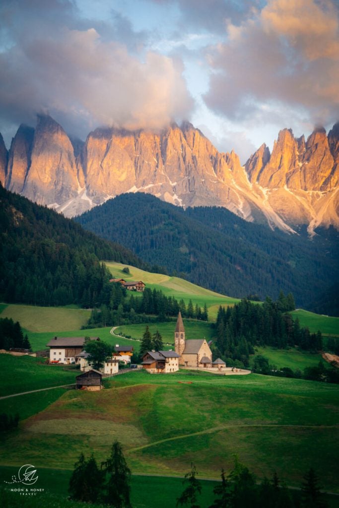
Santa Maddalena (St. Magdalena in German) is a village in Val di Funes (Villnösstal) in South Tyrol, Italy. This small mountain village is home to the historic Santa Maddalena Church, which is one of the most popular photo motifs in the region. It’s also the start of an excellent panoramic hike.
We love visiting Val di Funes. Usually, we scurry up to the Zannes mountain pasture to hike in Puez-Odle Nature Park. However, during our last trip to the Dolomites, we decided to hike the Panorama Trail (“Panoramaweg” in German) and the Sunny-side Trail (“Sunnseitnweg”), which when linked together creates an easy, scenic circuit hike.
The Santa Maddalena Panorama trail traverses meadows, pockets of forest, and historic Tirolean farmsteads along narrow footpaths as well as low trafficked paved roads.
You’ll see the very best views of the Odle/Geisler Peaks, which form the dramatic backdrop of Santa Maddalena Church. If you’re trying to reach the famous Santa Maddalena photo spot, follow this trail guide. It’ll lead you right there in 20-25 minutes.
This hike gives you a great overview of the Funes/Villnöss Valley. It’s the perfect outing for arrival days, or late afternoon/early evening strolls.
- Trailhead: Santa Maddalena Village, Val di Funes | Google Maps
- Santa Maddalena Car Parks: Berger Square, Filler, and Putzen
- Distance: 9.5 km circuit
- Time Needed: 3:30 hours
- Elevation Gain/Loss: 380 meters
- Difficulty: Easy
- Minimum Elevation: 1196 meters
- Maximum Elevation: 1394 meters
- Route: Santa Maddalena Village – Santa Maddalena Church – Vikolerhof – Runggatschhof – Gsoihof – Austillerhof – Santa Maddalena Church – Santa Maddalena Village
- When to Hike: May – October
- Where to Stay in Val di Funes: Appartements Pension Sonia (budget), Fallerhof (budget), Hotel Fines (midrange), Proihof (midrange), or Hotel Tyrol (luxury)
- Recommended Trail Map: Tabacco 030 Bressanone – Val di Funes
Panoramaweg and Sunnseitenweg Hiking Map
Where to Stay in Santa Maddalena, Val di Funes


The best place to stay for this hike and any other hike starting in Val di Funes is the village of Santa Maddalena. Here are three central options for every budget:
Budget | Appartements Pension Sonia is a no-frills, budget-friendly guesthouse in Santa Maddalena. Breakfast is included in the room rate.
Budget | Fallerhof is an active farm and a great-value apartment-style accommodation with stunning views of the Geisler Group. It’s a short walk to the Santa Maddalena Church (5 minutes) and the famous Chiesetta di San Giovanni in Ranui (15 minutes). It’s also an 11-minute drive (or 1.5-hour walk) to the Zannes/Zans trailhead. Breakfast is available upon request.
Midrange | Hotel Fines is a welcoming, 3-star hotel in Santa Maddalena, owned by a young and enthusiastic team. Guests love the rich breakfast buffet, central location, and hotel restaurant. Definitely book half board (breakfast and dinner) here. The DolomitiMobil Card is free for all guests.
Midrange | Proihof is a happily-situated farm stay in Santa Maddalena offering charming alpine rooms and apartments as well as stellar views of the Odle/Geisler Group. Stay here for the dreaming surroundings, farm animals, and down-to-earth atmosphere.
Luxury | Hotel Tyrol Dolomites is a family-run hotel in Santa Maddalena. This is the best place to stay when you want to combine outdoor exploration with wellness and relaxation. Their wellness area encompasses a Finnish sauna, steam bath, outdoor pool, whirlpool, and a garden with sun loungers and parasols. However, the main reason to stay here is their South Tyrolean cuisine, made with locally sourced ingredients. The DolomitiMobil Card is free for all guests. Tip: book half board and book a room with a Dolomites view (“Geisler Blick”).
Look for accommodation in Val di Funes.
Santa Maddalena Panoramaweg Trailhead
This hike begins directly in the village center of Santa Maddalena in Val di Funes.
To find out how to get here by car and/or bus, read How to Visit Val di Funes.
We started this trail directly at Hotel Tyrol, where we were staying. However, you can start anywhere in Santa Maddalena.
Note: you cannot drive directly to the Santa Maddalena Church.
Where to Park in Santa Maddalena
Here are the closest car parks to the Santa Maddalena Church. All of these car parks are pay-and-display.
Berger Square, Santa Maddalena | Google Maps
- Daily rate: 4 EUR
- Valley Guests with Dolomiti Card: 2 EUR
Filler Car Park, Santa Maddalena | Google Maps
- Daily rate: 4 EUR
- Valley Guests with Dolomiti Card: 2 EUR
Putzen Car Park | Google Maps
- Cars: 4 EUR
- Valley Guests with Dolomiti Card: 2 EUR
- Buses up to 2 hours: 10 EUR
- Buses daily rate: 20 EUR
St. Maddalena Car Park | Google Maps
This is a free car park in Santa Maddalena with limited capacity. Only 8 cars can park here.
Rules for Respectfully Visiting Santa Maddalena in Val di Funes
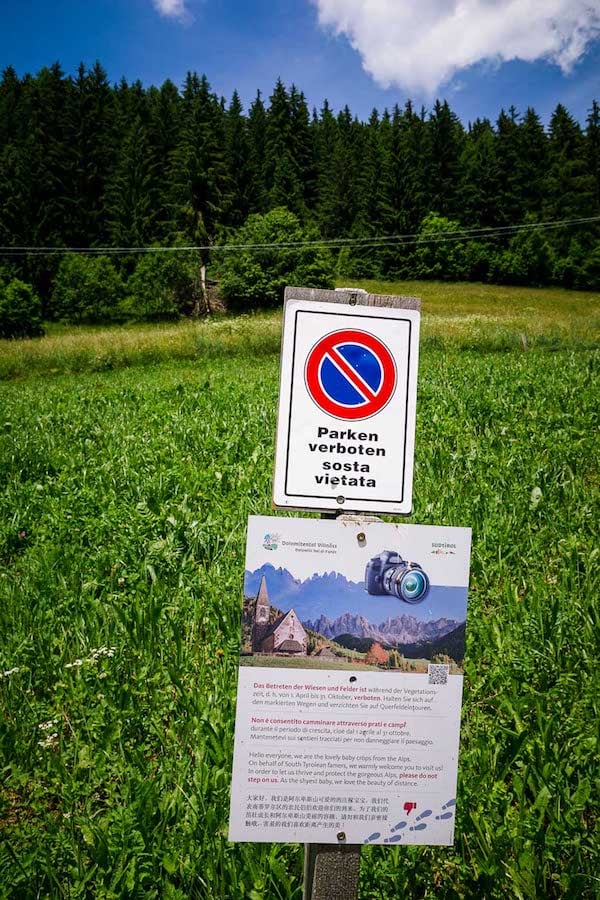


There are clear signs indicating how to respectfully visit. We’ve summarized the main points below:
Stay on marked trails. Do not hike across the meadows and fields (“Wiesen” in German).
Do not fly drones anwhere near the Santa Maddalena church or along the Panoramaweg trail.
Parking is forbidden along the Magdalenaweg road and Panoramaweg trail.
Santa Maddalena Val di Funes Panorama Hike Trail Description
Santa Maddalena Village to Santa Maddalena Church (10 – 15 minutes)

Santa Maddalena is home to about 370 inhabitants and is located in the upper part of Val di Funes at 1339 meters.
The village is tightly packed with homes, apartments, and hotels. This is the best base for exploring the valley and the trails leading into Puez-Odle Nature Park: Adolf Munkel Trail, Rifugio Genova Circuit, and Tullen Summit.
The Santa Maddalena Church is located above the village at an elevation of 1394 meters.
When you arrive in Santa Maddalena, head in the direction of Hotel Tyrol along the Kirchweg (“church path”) street. Hotel Tyrol has a striking, alpine modern facade – it’s easy to spot. Continue uphill to the Fallerhof Farm. As you ascend, the church is already visible ahead.
At Fallerhof Farm, turn left (trail 26/Kirchweg), passing in front of a large modern barn, home to dairy cows, and an enclosure of birds (chickens, ducks, and turkeys).
After a few meters, the trail veers right and uphill. This pathway leads directly to the Santa Maddalena Church.
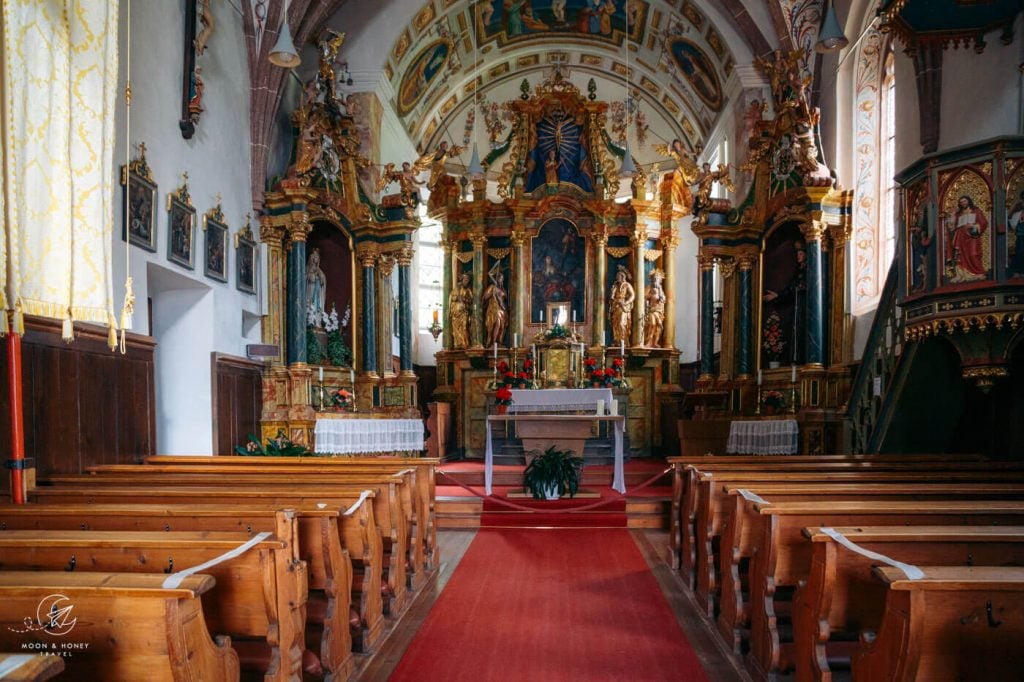
The Santa Maddalena church is open to visitors. There’s no fee to enter.
The interior is small and bright and dominated by baroque elements. The stone church dates back to the late 14th century. However, its location has been a place of pagan worship and sacrifice since prehistoric times.
Santa Maddalena Church to Santa Maddalena Photo Spot (10 minutes)

After visiting the church, continue north along the paved Magdalenaweg road. The road descends and you’ll soon pass the Plauer farmstead. After crossing the bridge over the Blauer Bach stream, keep your eyes out for a “Panoramaweg” trail sign on your right side.
Next to a sloping field, this narrow footpath ascends quickly for about 2 minutes. When the trail intersects with the paved road, you’ve arrived at the famous Santa Maddalena photo location.
Even if you’ve seen the photo a million times, words can’t quite capture how magical it is to experience it in person.

It’s a scene of unbelievable contrast. The piercing pinnacles of the Odle/Geisler group form the formidable backdrop of the tiny Santa Maddalena church, surrounded by rolling fields.
I wish I could travel back in time to see which pagan festivities took place here.
Panoramaweg Trail (1 hour)

Walk uphill along the road until you see the “Panoramaweg” trail sign, directing you west (left). Follow this pathway for about 150 meters to another trail intersection. Take the left trail.
You’ll continue heading west for some time. The undulating Panorama trail leads between meadows and forest.
After about 30 minutes along the Panorama trail, you’ll arrive at a trail juncture with a sign to Sunnseitenweg (also spelled Sunnseitnweg or Sunnenseitenweg).
This path is a shortcut. If you have less time, you can hike down this trail and join the Sunnseitenweg early, heading back to Santa Maddalena.
Otherwise, continue along the Panoramaweg for another 20 minutes.
Bergbauernweg (30 minutes)

Note: the trail gets a bit more confusing. We recommend buying at Tabacco 030 Bressanone – Val di Funes Map to better follow the trail. You can also use Maps.me and star/mark some of the farms mentioned below, so you know where you’re going.
When the Panoramaweg trail ends, you’ll continue on the Bergbauernweg (“mountain farm trail”), marked as trail 11 (direction: Vikoler Bild) on maps. Follow trail 11 right and uphill, along a wooden fence.
This part of the trail was a bit weird. Hang in there. You’ll hike uphill to SP163.
You’ll soon reach the SP163 road, where there’s a tiny white chapel and a bus stop. Cross the road cautiously. This is the road that leads to Passo delle Erbe (more info here: Sass de Putia hike), one of the most stunning mountain passes in the Dolomites.
The trail steeply ascends through the forest in the direction of the Vikoler Jöchl (small mountain pass). You’ll hike through the Vikolerhof Farm and then descend to the Rungatschhof Farm along a paved road. Follow signs to St. Peter.
Follow the road through the Rungatschhof Farm. Just after passing the lowest building, bare left and descend across the sloping meadow.
You’ll dip into a forest and then arrive at a trail intersection. Turn left, following signs to Sunnseitenweg.
Sunnseitnweg (1 hour)

Now you’re walking east towards the Odle/Geisler Peaks.
You’ll cross the SP163 road once more and continue to the Gsoihof farm (you can eat here).
Follow the road to another tiny chapel dating back to 1831.
The main Val di Funes valley road is just below.
At the next road intersection, head left towards Austillerhof farm. Shortly after passing the Austillerhof farm, the trail cuts left (uphill) across a meadow, leaving the road.

The Sunnseitenweg trail runs parallel to the panorama trail, just at a slightly lower elevation.
After 35 minutes walking along the Sunnseitenweg, you’ll rejoin the Panoramaweg. Follow the familiar trail back down to Santa Maddalena.

Golden Hour and Sunset Views of Santa Maddalena Church

After hiking the Panorama Trail, we returned to Hotel Tyrol for dinner. After dessert, we decided to walk back up to the viewpoint to watch the sunset.
Luckily, it’s only a 20-minute walk from the village to the viewpoint.
Dolomites Trip Planning Essentials
Use our Dolomites Travel Guide to plan an unforgettable trip to Northern Italy.
When to Hike in the Dolomites
Winter Season. For skiing and winter activities, the best time to visit is between mid/late December and March. To find out what to see and do during the festive advent season, read Dolomites in December.
Summer and Fall Seasons. The best time to road trip and hike in the Dolomites is between mid-June and mid-September. If the weather is stable, the hiking season can easily continue until late October.
How to Get to the Dolomites
Read How to Get to the Dolomites to find out how to travel to the Dolomites from the closest airports, train stations, and bus terminals.
If you’re traveling without a car, also check out How to Visit the Dolomites Without a Car.
Car Rental
The easiest way to travel between hiking destinations in the Italian Dolomites is with your own car. Check out our itineraries for trip inspiration:
We recommend using the Discovercars.com car rental reservation platform to search for and book car rentals. This easy-to-use booking platform compares car rental deals from 500+ trusted providers, so that you can choose the best option for your trip.
Tip: If you can only drive automatic transmission cars, as opposed to manual transmission cars (stick shift), book your car rental as early as possible.
Best Places to Stay
Figuring out where to stay in the Dolomites is probably the biggest hurdle to planning a trip to the Dolomites. We’ve created three guides to help you decide where to stay:
- Where to Stay in the Dolomites in Summer: best villages and towns in South Tyrol, Trentino and Belluno
- Best Hotels in the Dolomites: best boutique and luxury hotels in the Dolomites
- Dolomites Accommodation Guide: farm stays, mountain huts, wellness hotels, aparthotels
- Best Val Gardena Hotels: best accommodations in Ortisei, Santa Cristina, and Selva di Val Gardena
We suggest choosing 2-4 bases for your Dolomites trip and spending 2-4 nights in each base.
- Base 1: Val Gardena
- Base 2: Val di Funes
- Base 3: Alta Badia
- Base 4: Cortina d’Ampezzo
- Base 5: Alta Pusteria
- Base 6: San Martino di Castrozza
What to See & Do
During your trip to the Dolomites, you can go via ferrata climbing, culinary hiking, hut to hut hiking, cycling, paragliding, and so much more. We’ve highlighted our favorite experiences in Best Things to Do in the Dolomites.
Wherever you decide to stay, you’ll be surrounded by glorious mountain scenery and incredible natural landmarks.
In Best Places to Visit in the Dolomites, we’ve outlined the most iconic attractions as well as lesser-known destinations across the Dolomites, including Alpe di Siusi, Lago di Braies, and Lago di Sorapis.
Dolomites Hiking Guides
Hiking in the Dolomites is our passion. Year after year, we love discovering new trails and expanding our knowledge of the area. For day hiking, check out Best Day Hikes in the Dolomites. For trekking, take a look at our guide to Hut to Hut Hiking in the Dolomites and Alta Via 1.
For region-specific hiking trails, check out:
- Best Hikes in Val Gardena
- Best Hikes in Cortina d’Ampezzo
- Best Hikes in Alta Badia
- Sexten Dolomites Hiking Guide
- Puez-Odle Nature Park
Recommended Hiking Guidebook: Shorter Walks in the Dolomites (Cicerone Guide)

Hi,
Which trail in nicer?
Santa Maddalena Panorama Trail
or
Adolf Munkel Trail
Hi,
Both are lovely trails, but I would choose the Adolf Munkel Trail, because you get up close to the Geisler Peaks. And, Geisler Alm is a treat to visit.
-Sabrina
Hi,
Thank you for the helpful blog!
I have a question. We are couple with a toddler and we want to hike the trail you have described in this article, but with taking the shortcut that you have mentioned before to Sunnenseitenweg. So, I want to ask if you think that the trail this way (with the shortcut) is suitable with a stroller (we don’t mind if only a little part of it is not but the rest it is).
Another question if I may, how much time the trail needs using the shortcut to Sunnenseitenweg?
Thank you again!
Hi Moran,
I don’t think the trail is suitable for a stroller. It’s only paved in the beginning and at the end. But, please reach out to the Val di Funes tourist office. They may have some ideas.
Best of luck,
Sabrina
Hello,
We will be staying in Ortisei, is it practical to travel from Ortisei for a day trip in Santa Magdalena? Which trail do you think suits us best?
Hi Pimm,
Yes, it’s only a 40-minute drive from Ortisei to Santa Maddalena. You can do the Santa Maddalena Panorama Trail that starts in the village, or you can drive to Zannes/Zans at the end of the Val di Funes valley road and hike the Adolf Munkel Trail.
Have fun!
Sabrina
Hello, thank you for this blog!it’s stunning, I will be in Dolomites in end of the may, for the trip i inspire everything from your blog. I have a question, is it possible to download hiking trail and uplound in other aplication in my phone?
Hi,
You’re welcome.
I don’t know of a simple way to do this. What mobile application are you using?