This unforgettable Rifugio Mulaz circuit hike in the Pale di San Martino Dolomites is like a satisfying multi-course meal bursting with flavor, color, and texture.
It starts with an aperitif that stimulates your appetite: arriving at the Malga Venegia trailhead. It proceeds with an hors d’oeuvres that awakens your taste buds: walking through the heavenly Val Venegia.
And, it continues with an amuse-bouche that delights your visual palate: Malga Venegiota alpine pasture. As for the main course and the dessert, you’ll have to read on to find out.
We loved this particular Dolomites day hike because of how it unfolds. It’s never boring, and the rewards are many. When we thought this hike couldn’t possibly get better, it did, again and again.
- Trailhead: Val Venegia, Trentino, Italy
- Distance: 12.6 km lollipop-circuit
- Time Needed: 6:30 – 7 hours
- Elevation Gain/Loss: 1054 meters
- Difficulty: Moderately Difficult
- Route: Malga Venegia parking lot (1778 m) – Malga Venegiota (1824 m) – Passo Mulaz (2619 m) – Rifugio Mulaz (2571 m) – Sasso Arduini (2582 m) – Passo dei Fochet (2291 m) – Passo di Venegiota (2299 m) – Malga Venegiota (1824 m) – Malga Venegia parking lot (1778 m)
- Where to Eat: Rifugio Mulaz and Malga Venegiota
- Where to Stay: Residence Taufer (budget), Hotel Vienna (midrange), or Sayonara Nature & Wellness Hotel (luxury) in San Martino di Castrozza
- Recommended Trail Map: Tabacco 022 Pale di San Martino
Val Venegia to Rifugio Mulaz Hiking Map
When Can You Hike from Val Venegia to Rifugio Mulaz
Late June until early October, depending on weather and snow conditions.
Rifugio Mulaz is open from mid-June until late-September.
How to Get to Val Venegia

Val Venegia is located between Passo Rolle and Passo Valles in Trentino.
The closest towns are San Martino di Castrozza and Predazzo.
San Martino di Castrozza to Val Venegia
The drive from San Martino di Castrozza takes about 34 minutes (19.6 km).
Head North on SS50 Passo Rolle. Continue to follow SS50.
Make a sharp right onto SP81 (signs for Falcade/Belluno) in the direction of Passo Valles. Turn right to enter Val Venegia.
Predazzo to Val Venegia
The drive from Predazzo takes about 30 minutes (18.7 km).
Head east on SS50 towards Passo Rolle. Turn left onto SP81 (signs for Falcade/Belluno) in the direction of Passo Valles. Turn right to enter Val Venegia.
Parking in Val Venegia
There are two main parking areas in Val Venegia: Pian dei Casoni and Parcheggio Malga Venegia. For this specific hike, we recommend parking at Parcheggio Malga Venegia.
Important: Parking is strictly prohibited in Val Venegia between 9:00 pm and 7 am.
Parcheggio Val Venegia Pian dei Casoni
Soon after entering the valley, you’ll see the Pian dei Casoni parking lot. When parking here between 8 am and 5 pm, the fee structure is as follows:
- Car: 3 EUR for 4 hours
- Car: 5 EUR for all day parking
- Campervan/RV: 4.50 EUR for 4 hours
- Campervan/RV: 7.50 EUR for all day parking
To pay for your parking, use the blue parking ticket machine. These machines only accept coins (2 EUR, 1 EUR, .50 EUR, .20 EUR, .10 EUR, and .05 EUR).
Remember to bring the exact amount of cash in EUR coins.
Parcheggio Malga Venegia
This parking lot is located at the Malga Venegia alpine pasture, just below the Malga Venegia hut. We recommend parking here.
In order to drive to Parcheggio Malga Venegia, you have to pay a 7 EUR toll between the hours of 8 am and 4 pm.
Pay the fee to the collector and drive 1.2 km to the parking lot.
Related: Best Day Hikes in the Dolomites
Val Venegia to Rifugio Mulaz Trail Description

Val Venegia to Malga Venegiota (30 minutes)

From the parking lot at the Malga Venegia alpine pasture, follow the gravel road through Val Venegia valley to Malga Venegiota.
The gravel road cuts across alpine pastures, where free-roaming cattle graze in summer. For safety reasons, it’s important to maintain a safe distance and avoid disturbing these animals.
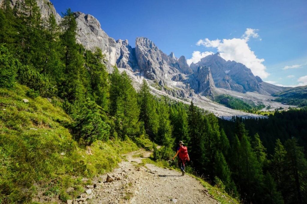
As you follow the road, you’re walking towards the northern chain of the Pala Group, which towers magnificently over the valley. As you progress, you’ll walk along the Torrento Travignolo stream and through a pine forest.
The Malga Venegiota alpine pasture hut is a destination in and of itself. To say it’s perfectly situated is an understatement. We grabbed a coffee and a cake here, before continuing on.
Malga Venegiota to Passo Mulaz and Rifugio Mulaz (1:40 – 2 hours)

From the Malga Venegiota hut, continue walking along the gravel road for about 10 minutes. At the trail intersection, turn left onto trail 710, in the direction of Rifugio Mulaz (signed 2 hours). Shortly thereafter (5 meters), turn right to stay on trail 710.
The trail gently ascends through the forest. When you get above the timberline, you’ll hike along switchbacks, steadily gaining elevation. There are some steel cables along the route.
If hiking in the morning, the ascent to Passo Mulaz feels quite manageable, because the trail is in shade almost the whole time.
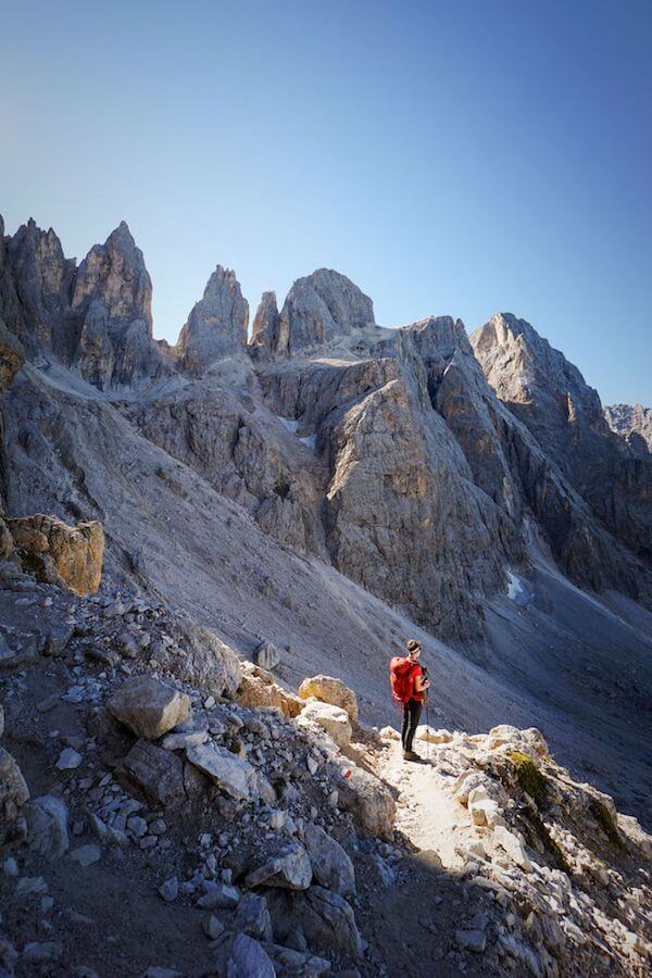
As you near Passo Mulaz, the trail turns to scree and becomes steeper and steeper. Don’t forget to look behind you, as the morning light engulfs the valley and illuminates the Pala peaks.
At Passo Mulaz, it’s a 10 minute descent to Rifugio Mulaz along trail 751. Eat lunch here.
Optional: Monte Mulaz Summit (1 hour one-way)
Many hikers who venture up to Passo Mulaz and Rifugio Mulaz also hike to the summit of Monte Mulaz.
We skipped it, because we were so beat from the hike to Cima della Vezzanna. However, on another day, that’s something we definitely would have done.
Rifugio Mulaz to Passo di Venegiota (2:30 hours)

Follow trail 751 in the direction of Sasso Arduini peak (2582). Soon after leaving the Rifugio, the trail divides. Take the upper, left track, and follow signs to Passo Valles.
Before reaching the summit of Sasso Arduini (which is a detour), trail 751 veers left and downhill. It’s easy to miss, if you’re fixated on heading to the summit.
The descent is initially a bit tricky. The path requires careful footing as you negotiate some rocky hairpins. There are some rusty steel cables that help you manage a slippery/watery section. We were happy to have our black diamond climbing gloves with us.

After about an hour, the trail nears a tiny tarn that makes for a great afternoon resting spot.
From here, you’ll descend through a gully along a secured path.
The trail levels out for a while, before dipping, and then diagonally ascending a rocky slope to Passo dei Fochet (2291 m).
From the pass, bear left and follow the balcony trail to a notch. At the notch, you’ll emerge on the northern side of the Pala peaks.
Descend 5 minutes to Passo di Venegiota (5 minutes). At the pass, the trail sign indicates 45 minutes to Malga Venegiota.
Passo di Venegiota to Malga Venegiota (1 hour)

The trail descends gently across tussock slopes, peppered with boulders and the occasional stone pine or larch tree. It’s easy walking from here on out.
With delicious views of the Pala mountains, this sublime stretch of trail feels like the ultimate dessert. Shockingly, there was no one hiking this path.
As you continue, pay heed to the wooden pole trail markers. At one point, the trail splits and it’s easy to lose sight of your way, because of the poor waymarking. Make sure to follow the poles and stay left.
Eventually, the trail reaches the timberline. Head left onto trail 749, following signs to Val Venegia. Continue descending through the pine and larch forest until reaching the valley floor. When you reach the gravel road, turn right and walk the familiar track back to Malga Venegiota.

When we arrived at Malga Venegiota in the late afternoon, they had already stopped serving warm food.
Luckily, they were still serving homemade yogurt with berries as well as beverages. We highly recommend the yogurt. Taking a break at this hut post-hike is almost compulsory.
Malga Venegiota to Malga Venegia (30 minutes)

Follow the gravel road back to the parking lot at Malga Venegia.
Where to Stay in San Martino di Castrozza
The best base for this hike and many others in Pale di San Martino is San Martino di Castrozza. This alpine resort town is a 34-minute drive to Val Venegia.
From San Martino di Castrozza, you’re well-positioned to hike to Baita Segantini for sunset, ascend to the central plateau of the Pala Group and tackle the Pala di San Martino Circuit Hike (Rifugio Rosetta to Rifugio Pradidali) and the summit of Cima della Vezzana.
Budget | Residence Taufer is an affordable apartment-style accommodation, located 1 km from the center of San Martino di Castrozza. Apartments are clean and fully equipped, with all necessary appliances to make your stay here comfortable. The check-in/check-out is easy and uncomplicated. There’s a welcoming bar downstairs, where you can order espresso, drinks, and snacks throughout the day. And, the views of the Pala Group are sublime!
Midrange | Hotel Vienna is a welcoming family-run hotel, set in the heart of San Martino di Castrozza. This 3-star hotel delivers gorgeous mountain views, cozy and spacious rooms, and a great breakfast. The staff is very friendly and helpful.
Luxury | Sayonara Nature & Wellness Hotel is a top-rated luxury hotel in San Martino di Castrozza. Stay here for the spacious, alpine-modern rooms, the rich and varied breakfast buffet, and the 1000 m2 spa and wellness area. The hotel is a 5-minute walk to the center of town. The hotel’s on-site restaurant is open daily for dinner.
Look for accommodation in San Martino di Castrozza.

Dolomites Trip Planning Essentials
Use our Dolomites Travel Guide to plan an unforgettable trip to Northern Italy.
When to Hike in the Dolomites
The best time to hike in the Dolomites is between mid-June and mid-September. If the weather is stable, the hiking season can extend until late October.
How to Get to the Dolomites
Read How to Get to the Dolomites to find out how to travel to the Dolomites from the closest airports, train stations, and bus terminals.
If you’re traveling without a car, also check out How to Visit the Dolomites Without a Car.
Car Rental
The easiest way to travel between hiking destinations in the Italian Dolomites is with your own car. Check out our itineraries for trip inspiration:
We recommend using the Discovercars.com car rental reservation platform to search for and book car rentals. This easy-to-use booking platform compares car rental deals from 500+ trusted providers, so that you can choose the best option for your trip.
Tip: If you can only drive automatic transmission cars, as opposed to manual transmission cars (stick shift), book your car rental as early as possible.
Best Places to Stay
Figuring out where to stay in the Dolomites is probably the biggest hurdle to planning a trip to the Dolomites. We’ve created three guides to help you decide where to stay:
- Where to Stay in the Dolomites in Summer: best villages and towns in South Tyrol, Trentino and Belluno
- Best Hotels in the Dolomites: best boutique and luxury hotels in the Dolomites
- Dolomites Accommodation Guide: farm stays, mountain huts, wellness hotels, aparthotels
- Best Val Gardena Hotels: best accommodations in Ortisei, Santa Cristina, and Selva di Val Gardena
We suggest choosing 2-4 bases for your Dolomites trip and spending 2-4 nights in each base.
- Base 1: Val Gardena
- Base 2: Val di Funes
- Base 3: Alta Badia
- Base 4: Cortina d’Ampezzo
- Base 5: Alta Pusteria
- Base 6: San Martino di Castrozza
What to See & Do
During your trip to the Dolomites, you can go via ferrata climbing, culinary hiking, hut to hut hiking, cycling, paragliding, and so much more. We’ve highlighted our favorite experiences in Best Things to Do in the Dolomites.
Wherever you decide to stay, you’ll be surrounded by glorious mountain scenery and incredible natural landmarks.
In Best Places to Visit in the Dolomites, we’ve outlined the most iconic attractions as well as lesser-known destinations across the Dolomites, including Alpe di Siusi, Lago di Braies, and Lago di Sorapis.
Dolomites Packing List
Hiking Gear
- Day Pack: Osprey Tempest 30 Women’s Backpack / Osprey Talon 33 Men’s Backpack
- Grade B/C high-cut hiking boots: Meindl Schuhe Island Lady (Kati’s Boots), Women’s Hanwag Tatra II GTX (Sabrina’s Boots), Men’s Hanwag Tatra II GTX (men’s equivalent)
- CAT 4 Sunglasses: Julbo Shield Mountain Sunglasses
- Hiking Poles: Black Diamond Trail Trekking Poles
Outdoor Photography Gear
- Camera Body: Sony Alpha a6400
- Mid-range Zoom Lens: Tamron 17-70mm 2.8 Di III-A VC RXD
- Wide angle Zoom Lens: Sony – E 10-18mm F4 OSS Wide-angle Zoom Lens
- Backpack Camera Clip: Peak Design Camera Clip
Dolomites Hiking Guides
Hiking in the Dolomites is our passion. Year after year, we love discovering new trails and expanding our knowledge of the area. For day hiking, check out Best Day Hikes in the Dolomites. For trekking, take a look at our guide to Hut to Hut Hiking in the Dolomites and Alta Via 1.
For region-specific hiking trails, check out:
- Best Hikes in Val Gardena
- Best Hikes in Cortina d’Ampezzo
- Best Hikes in Alta Badia
- Sexten Dolomites Hiking Guide
- Puez-Odle Nature Park
Recommended Hiking Guidebook: Cicerone Guide: Shorter Walks in the Dolomites

Hello,
thank you for your articles! Your blog is a big helper for almost every hike we do.
I would like to ask you regarding this hike and specifically trail 751 (as you say The descent is initially a bit tricky. The path requires careful footing as you negotiate some rocky hairpins. There are some rusty steel cables that help you manage a slippery/watery section. We were happy to have our black diamond climbing gloves with us). Is it possible to hike there for with a big dog that we are not able to carry in hands.
Thank you very much in advance,
Katerina
Hi Katerina,
You’re very welcome.
A dog should be ok, but I can’t say for sure. Please reach out to the tourist office in San Martino for their expert opinion.
Sorry I can’t be more helpful,
Sabrina
4 of us just completed this hike on the 22nd June 2023. It’s a great hike, unquestionably! There was, unfortunately, still too much snow on Trail 751, and with high temperatures everyone was told by the staff at Rifugio Mulaz to avoid that route down and go back the same way.
Just to add for the website owner Sabrina – the trail is 710, NOT 720 (trail 720 does not exist!). But it’s well sign-posted at the start so it’s pretty obvious.
As a side note, this is a fantastic website with some brilliant recommendations and suggestions for hikes – thank you!
Hi Marco,
Thanks for reaching out! The trail number has been fixed.
All the best,
Sabrina
Just to note that it’s trail 710, not 720 – there is no trail 720!
Hi Marco,
Thank you for catching that. I just double-checked and you’re absolutely right!
– Sabrina