Hiking from Rifugio Rosetta to Rifugio Pradidali in the Pale di San Martino Group in the Italian Dolomites is like walking on the moon, or a vast ocean of stone.
With the help of two cableways from San Martino di Castrozza, hikers ascend to the Altopiano delle Pale di San Martino plateau to start the loop trail around Pala di San Martino (2987 m), a prominent mountain in the central Pala Group.
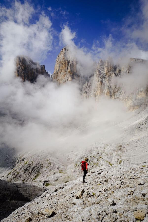
This demanding day hike feels like an intimate exploration of the Pala range. You’re exploring the very heart of the magnificent Pale di San Martino mountains.
Because this hike circuits Pala di San Martino, this trail is generally called: Giro della Pala di San Martino (Tour of the Pala di San Martino).
- Starting Point: Colverde Gondola Valley Station in San Martino di Castrozza, Trentino, Italy
- Trailhead: Rosetta Cableway Mountain Station
- Distance: 12.1 km circuit
- Time Needed: 6 hours
- Elevation Gain/Loss: 909 meters
- Difficulty: Moderately Difficult
- Route: Rosetta Cableway Mountain Station (2635 m) – Rifugio Rosetta (2581 m) – Passo di Val di Roda (2580 m) – Col delle Fede (2278) – Passo di Ball (2451 m) – Rifugio Pradidali (2278 m) – Passo Pradidali Basso (2658 m) – Rifugio Rosetta (2581 m) – Col Verde-Rosetta cableway mountain station (2635 m)
- Where to Eat: Rifugio Rosetta or Rifugio Pradidali
- Where to Stay: Residence Taufer (budget), Hotel Vienna (midrange), or Sayonara Nature & Wellness Hotel (luxury) in San Martino di Castrozza
- Recommended Trail Map: Tabacco 022 Pale di San Martino
Pala di San Martino Circuit Hiking Map
Hiking around Pala di San Martino: Safety and Difficulty

This hike requires good, stable weather. If conditions are poor, this loop trail can be potentially dangerous. Without proper visibility, it’s easy to get lost.
This hike also requires some alpine hiking experience. You should be confident hiking up/down scree and rocky karst terrain.
Furthermore, you should have a head for heights. There’s one lengthy secured passage, which is easily managed without equipment.
Nonetheless, we highly recommend climbing gloves, which makes grasping steel cables more comfortable. This passage could pose a real challenge to anyone afraid of heights.
Getting to the Trailhead: Colverde Gondola Valley Station
This hike requires an ascent and descent with the Colverde gondola and the Rosetta Cableway. The Colverde Gondola valley station is located in San Martino di Castrozza. There’s a free parking lot at the valley station.
Check current pricing for the Colverde and Rosetta return combi-ticket.
Colverde Gondola
Location | San Martino di Castrozza
Open | Late June until Late September daily. Starting in late September until mid-October, the Colverde Gondola is only operating on the weekends.
Operating Times | 8:15 am – 4:50 pm
Pricing | Check current pricing
Rosetta Cableway
Location | Colverde Mountain Station, San Martino di Castrozza
Open | Late June until Late September daily. Starting in late September until mid-October, the Rosetta Cableway is only operating on the weekends.
Operating Times | 8:30 am – 4:40 pm (not working from 1 pm to 1:40 pm)
Pricing | Check current pricing
Related: Top Things to Do in San Martino di Castrozza
Which Direction to Hike around Pala di San Martino

From Rifugio Rosetta, you can either hike to Rifugio Pradidali via Passo di Ball (recommended), or via Passo Pradidali Basso.
The latter is more popular, but we think it’s better to hike counter-clockwise. By hiking to Passo di Ball first, you’ll ascend a long secured section, which is significantly easier than descending.
Also, the trail from Rifugio Pradidali to Passo Pradidali Basso has some difficult passages across crumbling scree terrain, which is safer to ascend.
When can you hike around Pala di San Martino
Late June until mid-October, weather permitting.
If you’re hiking here between late September and mid-October, the cableways are only open on the weekend.
We recommend hiking this trail in early-mid September when the weather is generally stable and there are fewer visitors.
Rifugio Rosetta and Rifugio Pradidali Circuit Trail Description

Rosetta Cableway Mountain Station to Rifugio Rosetta (15 minutes)
Upon exiting the Rosetta mountain station, Rifugio Rosetta is immediately visible.
The three-story mountain hut with blue and white shutters is located on the Altopiano Pale di San Martino plateau, which looks like a sea of bleached stone.
Rifugio Rosetta to Passo di Ball (1:45 – 2 hours)

The circuit trail around Pala di San Martino begins at Rifugio Rosetta.
From the hut, locate trail 702 to Rifuguio Pradidali, signed 2 hours. After about 10 minutes, you’ll reach Passo Val di Roda (2560 m). Shortly thereafter, the trail descends sinuously along switchbacks. Though this part is a bit monotonous, it’s not difficult.
When the trail levels, the mountains captivate with their unique shapes and pale hues. Skirting the base of Croda di Roda, continue south.
A grassy plateau – Col delle Fede (2278 m) – invites you to take a break, and marvel at the scenery before you. Straight ahead, you’ll see a dramatic mule track zigzagging its way up from Val di Roda to the plateau.
Continue following this level, linear path – now trail 715.
Soon, you’ll encounter the first steel cable. With the help of fixed cables, you’ll ascend to Passo di Ball along narrow passages. This is a rather long secured passage, but it’s not overly difficult (for experienced hikers), and it makes the hike far more interesting.
Some light scrambling might be needed. You’ll arrive at the grass-carpeted Passo di Ball before you know it.
Read Next: Best Day Hikes in the Dolomites
Passo di Ball to Rifugio Pradidali (25 minutes)

Passo di Ball is the mountain pass between Cima di Ball and Cima Pradidali.
From Passo di Ball, trail 715 descends to Rifugio Pradidali. This is a lovely trail that meanders through boulders, before dropping down to the Pradidali Hut. Behind the hut, the towering Cima Canali pierces the clouds.
Rifugio Pradidali to Passo Pradidali Basso (1:15 hours)

From Rifugio Pradidali, follow trail 709 in the direction of Lago Pradidali lake. The trail ascends the upper Val Pradidali valley all the way to the central plateau of Pale di San Martino.
After passing the small lake, the trail steadily climbs up the valley, which is flanked by Cima Pradidali and Cima Immink on the left-side (west) and Cima Canali and Cima Wilma on the right (east).

You’ll ascend from one terrace to another. Some scrambling is needed.
When you reach an intersection (~45 minutes after leaving the hut), turn left to stay on trail 709.
Continue hiking up another 25 minutes to reach Passo Pradidali Basso (2658 m).
Passo Pradidali Basso to Rifugio Rosetta (1 hour)

Passo Pradidali acts like an entryway to the vast, lunar landscape of Altopiano Pale di San Martino. As far as the eye can see, bleached white stone extends in every direction.
Follow the painted waymarks across the rolling rockscapes all the way to Rifugio Rosetta.
Initially, you’ll cut across a rock wall, before tackling the long undulating stone sea. Attention is needed because this isn’t a flat, easy-going finale. It’s up and down and requires careful footing.

When trail 709 ends, join trail 707, bearing left.
Rifugio Rosetta to Rosetta Cableway Mountain Station (15 minutes)
To complete the circuit, hike back to the Rosetta mountain station.
Where to Stay in San Martino di Castrozza
The best base for this hike and many others in Pale di San Martino is San Martino di Castrozza. The Colverde gondola valley station is located directly in town.
From San Martino di Castrozza, you’re well-positioned to hike to Baita Segantini for sunset, ascend to the central plateau of the Pala Group to tackle the summit of Cima della Vezzana, and visit Val Venegia to hike to Rifugio Mulaz.
Budget | Residence Taufer is an affordable apartment-style accommodation, located 1 km from the center of San Martino di Castrozza. Apartments are clean and fully equipped, with all necessary appliances to make your stay here comfortable. The check-in/check-out is easy and uncomplicated. There’s a welcoming bar downstairs, where you can order espresso, drinks, and snacks throughout the day. And, the views of the Pala Group are sublime!
Midrange | Hotel Vienna is a welcoming family-run hotel, set in the heart of San Martino di Castrozza. This 3-star hotel delivers gorgeous mountain views, cozy and spacious rooms, and a great breakfast. The staff is very friendly and helpful.
Luxury | Sayonara Nature & Wellness Hotel is a top-rated luxury hotel in San Martino di Castrozza. Stay here for the spacious, alpine-modern rooms, the rich and varied breakfast buffet, and the 1000 m2 spa and wellness area. The hotel is a 5-minute walk to the center of town. The hotel’s on-site restaurant is open daily for dinner.
Look for accommodation in San Martino di Castrozza.

Dolomites Trip Planning Essentials
Use our Dolomites Travel Guide to plan an unforgettable trip to Northern Italy.
When to Hike in the Dolomites
The best time to hike in the Dolomites is between mid-June and mid-September. If the weather is stable, the hiking season can extend until late October.
How to Get to the Dolomites
Read How to Get to the Dolomites to find out how to travel to the Dolomites from the closest airports, train stations, and bus terminals.
If you’re traveling without a car, also check out How to Visit the Dolomites Without a Car.
Car Rental
The easiest way to travel between hiking destinations in the Italian Dolomites is with your own car. Check out our itineraries for trip inspiration:
We recommend using the Discovercars.com car rental reservation platform to search for and book car rentals. This easy-to-use booking platform compares car rental deals from 500+ trusted providers, so that you can choose the best option for your trip.
Tip: If you can only drive automatic transmission cars, as opposed to manual transmission cars (stick shift), book your car rental as early as possible.
Best Places to Stay
Figuring out where to stay in the Dolomites is probably the biggest hurdle to planning a trip to the Dolomites. We’ve created three guides to help you decide where to stay:
- Where to Stay in the Dolomites in Summer: best villages and towns in South Tyrol, Trentino and Belluno
- Best Hotels in the Dolomites: best boutique and luxury hotels in the Dolomites
- Dolomites Accommodation Guide: farm stays, mountain huts, wellness hotels, aparthotels
- Best Val Gardena Hotels: best accommodations in Ortisei, Santa Cristina, and Selva di Val Gardena
We suggest choosing 2-4 bases for your Dolomites trip and spending 2-4 nights in each base.
- Base 1: Val Gardena
- Base 2: Val di Funes
- Base 3: Alta Badia
- Base 4: Cortina d’Ampezzo
- Base 5: Alta Pusteria
- Base 6: San Martino di Castrozza
What to See & Do
During your trip to the Dolomites, you can go via ferrata climbing, culinary hiking, hut to hut hiking, cycling, paragliding, and so much more. We’ve highlighted our favorite experiences in Best Things to Do in the Dolomites.
Wherever you decide to stay, you’ll be surrounded by glorious mountain scenery and incredible natural landmarks.
In Best Places to Visit in the Dolomites, we’ve outlined the most iconic attractions as well as lesser-known destinations across the Dolomites, including Alpe di Siusi, Lago di Braies, and Lago di Sorapis.
Dolomites Packing List
Hiking Gear
- Day Pack: Osprey Tempest 30 Women’s Backpack / Osprey Talon 33 Men’s Backpack
- Grade B/C high-cut hiking boots: Meindl Schuhe Island Lady (Kati’s Boots), Women’s Hanwag Tatra II GTX (Sabrina’s Boots), Men’s Hanwag Tatra II GTX (men’s equivalent)
- CAT 4 Sunglasses: Julbo Shield Mountain Sunglasses
- Hiking Poles: Black Diamond Trail Trekking Poles
Outdoor Photography Gear
- Camera Body: Sony Alpha a6400
- Mid-range Zoom Lens: Tamron 17-70mm 2.8 Di III-A VC RXD
- Wide angle Zoom Lens: Sony – E 10-18mm F4 OSS Wide-angle Zoom Lens
- Backpack Camera Clip: Peak Design Camera Clip
Dolomites Hiking Guides
Hiking in the Dolomites is our passion. Year after year, we love discovering new trails and expanding our knowledge of the area. For day hiking, check out Best Day Hikes in the Dolomites. For trekking, take a look at our guide to Hut to Hut Hiking in the Dolomites and Alta Via 1.
For region-specific hiking trails, check out:
- Best Hikes in Val Gardena
- Best Hikes in Cortina d’Ampezzo
- Best Hikes in Alta Badia
- Sexten Dolomites Hiking Guide
- Puez-Odle Nature Park
Recommended Hiking Guidebook: Cicerone Guide: Shorter Walks in the Dolomites
