Seceda is a mountain in the Odle/Geisler Group situated within Puez-Odle Nature Park in South Tyrol in Northern Italy.
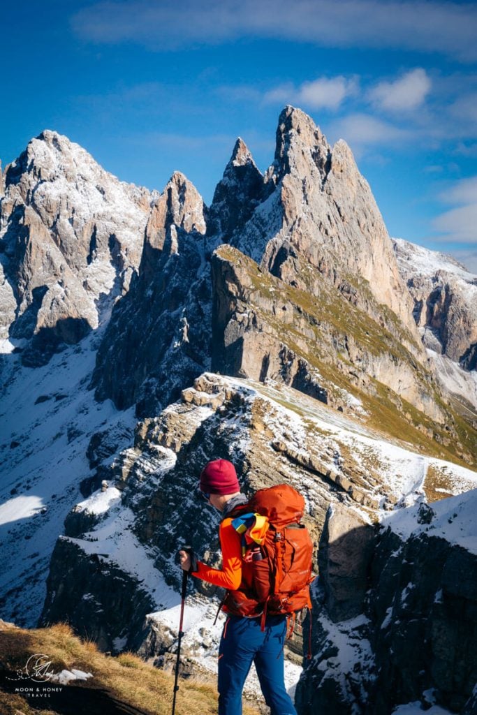
The summit of Seceda (2519 meters) is a dearly loved destination in the Dolomites because of its unbeatable view of the Odle/Geisler Peaks.
Atop Mount Seceda, the Odle peaks look like a Swiss army knife, eternally destined to slash the sky. It’s one of the most memorable mountain views in the Italian Dolomites.
The easiest and fastest way to get to Seceda is to ascend with the Ortisei-Furnes-Seceda Cableways from Ortisei in Val Gardena. During the summer season, the Seceda cableways usually operate between end of May and early November, between 8:30 am and 5:30 pm.
From the Seceda mountain station, it’s a mere 10-minute walk to the summit lookout point. From here, you can continue hiking along the Seceda ridgeline towards the Odle Peaks.
The spectacular Seceda ridge is just the beginning of a highly-satiating circuit trail to Rifugio Firenze/Regensburger Hütte. In this trail guide, we’re going to outline the details of this easy-moderate day hike.
If you’re looking for a more challenging ascent route to Seceda, also check out this Resciesa/Raschötz Plateau to Seceda day hike. And, if you’re determined to hike to Seceda without a cable car, read this Monte Pic and Seceda trail guide.
- Starting Point: Ortisei-Furnes-Seceda Cableway Valley Station, Ortisei | Google Maps
- Cableways: Ortisei-Furnes (gondola) and Furnes-Seceda (aerial cable car)
- Trailhead: Seceda Cableway mountain station
- Distance: 8.9 km circuit
- Time Needed: 3:15 hours without breaks
- Elevation Gain/Loss: 524 meters
- Difficulty: Easy – Moderate
- Minimum Elevation: 2038 meters
- Maximum Elevation: 2519 meters
- Trails: 6, 1, 2B, 13B, 13, 1
- Route: Seceda Mountain Station (2500 m) – Seceda Panorama Point (2519 m) – Furcella de Pana/Panascharte (2439 m) – Pieralongia (2297 m) – Rifugio Firenze/Regensburger Hütte (2037 m) – Lech da Iman (2225 m) – Baita Troier (2250 m) – Seceda Mountain Station (2500 m)
- Where to Stay in Ortisei: Hotel Garni Walter (midrange), Casa al Sole (bed and breakfast), Chalet Hotel Hartmann – Adults Only (midrange), Hotel Gardena Grödnerhof (luxury), or Adler Spa Resort Dolomiti (luxury)
- Recommended Trail Map: Tabacco 05 Val Gardena – Alpe di Siusi
Seceda Hiking Map
When to Hike to Seceda, Dolomites

It’s possible to hike to Seceda from late May until early November.
The best time to hike to Seceda is between June and mid/late October, when the trail is usually clear of snow.
Our favorite time to visit is in Autumn (mid September – late October), when there are less people, but the weather is still stable.
You can monitor the conditions atop Seceda by looking at this Seceda webcam.
Hiking Seceda in May 2024
If you’re visiting the Dolomites in May, before the Seceda cableways are operating, you can hike up to Seceda from Val Gardena.
We recommend starting the Seceda hike at the Praplan car park above Santa Cristina. Follow this Monte Pic and Seceda trail guide.
If you’re attempting this hike in early-mid May, please ask the Val Gardena tourist office about current trail conditions. If there’s a lot of snow, it may not be safe to hike to Seceda.
Another option is to park at the Col Raiser gondola valley station car park in Selva in Val Gardena.
From the Col Raiser valley station, it’s a 6 km hike to the Seceda ridgeline. It will take 3 hours at least to climb 984 meters up to Seceda. Follow trail 1 and later 1A to get to the Seceda Peak.
Hiking Seceda in Summer and Fall 2024
Generally, the Seceda cableways operate between late May and early November. The operating hours are 8:30 am until 5:30 pm.
Visiting Seceda in Winter: January – Early April
In winter, the Seceda Alm is used as a ski slope. From the summit, you can ski down to Ortisei, or Santa Cristina.
The Seceda ski area is part of the the Seceda-Col Raiser-Rasciesa skiing consortium.
How to Get to Seceda, Val Gardena
Step 1: Head to the Seceda Cableway Valley Station in Ortisei, Val Gardena

Walking Directions
If you’re arriving in Ortisei/St. Ulrich by bus, get off at Piazza S. Antonio/Antoniusplatz in the village center.
It takes about 5 minutes to walk from the center of Ortisei to the Seceda cableway, using the La Curta pedestrian connection.
From Antonio Square, look for a sign to “Seceda.” Head down the small street between Sparkasse Ortisei Bank and Calzature Rabanser Di Senoner Emilia shoe store.
Take the covered “La Curta” escalator up. After the escalator, locate the pedestrian tunnel straight ahead with a conveyor belt walkway.
When you reach the end of the tunnel, you’ll arrive at the Seceda cableway valley station.
Driving and Parking Directions
You can drive directly to the Seceda cableway valley station, which is located on Via Val d’Anna 2, I-39046 Ortisei, Val Gardena, South Tyrol. Exact Location: Google Maps.
There’s a paid parking garage directly at the valley station with a capacity of 250 spaces.
The parking fee is 1.90 EUR per hour with a daily maximum of 13 EUR.
At night, the price is 0.50 EUR per hour with a maximum fee of 19 EUR for 24 hours.
Step 2: Purchase a Round-Trip Ticket to Seceda
To get to Seceda, you have to take the Ortisei-Furnes gondola followed by the Furnes-Seceda cable car.
When you purchase your cableway ticket, you’ll be asked whether you want to go to Furnes (middle station) or Seceda (top station). Purchase a round-trip ticket to Seceda.
Ortisei-Furnes-Seceda Cableway Pricing
Adults (ages 16+) | 39.50 EUR round-trip
Juniors (ages 8 – 15) | 21 EUR round-trip
Children (ages 0 – 7) | Free
Dogs | 5 EUR
If you want to hike to Seceda without a cable car, we recommend this ascent route.
Step 3: Ascend to the Seceda Mountain Station (2 Cableways)
Hop on the Ortisei-Furnes gondola to the Furnes middle station.
At Furnes, disembark the gondola and walk a few meters to the Furnes-Seceda cableway station. Hop on the Furnes-Seceda aerial cable car to the Seceda mountain station.
Seceda Hiking Trail Description
Seceda Mountain Station to Seceda Summit / Photo Spot (10 minutes)

When you disembark the Seceda cableway mountain station, you will immediately see the slanted and formidable Odle/Geisler peaks.
The panoramic view extends to the Puez Group, including Piz Duleda (2909 m), Col dala Pieres (2747 m), and Monte de Stevia (2500 m), as well as the Sella Group and Sassolungo Group.
Follow the sign to the Seceda summit and photo spot.
It takes about 10 minutes to reach Mount Seceda (2518 meters). The summit is crowned with a Gipfelkreuz (summit cross) and a circular, metal structure indicating the names and elevations of prominent peaks in the Italian Alps and Austrian Alps, which are visible from this vantage point.
Looking to the left of the vicious Seceda ridgeline, you can see the summits of Medalges (2454 m), Sobutsch (2486 m), and Sass de Putia/Peitlerkofel (2,875 m), the northernmost mountain in the Puez-Odle Dolomites.
The range flanking Val di Funes to the north is Odles d’Eores/Aferer Geisler. Insider Tip: If you visit Val di Funes, we highly recommend hiking to Tullen, the highest summit of the Odles d’Eores mountains.
For context, the trail directly to the north of Seceda, at the base of the Odle/Geisler mountains, is the famous Adolf Munkel Trail.

Near the summit, a narrow, semi-exposed path leads to another interesting viewpoint, located at a slightly lower elevation.
Hiking here is completely optional. Only hike to this Seceda photo spot if you have no fear of heights and the conditions are dry.
Seceda Summit to Pieralongia (40 minutes)

The trail continues along the Seceda ridge in the direction of the Fermeda peaks: Pitla Fermeda, Grana Fermeda, and Gran Odla.
The entire path is embedded with cement blocks and lined with fences on both sides. The path is reinforced in order to thwart erosion and for safety, as it’s easier to grip cement than wet and muddy grass.
Please do not bypass the fences for photos.
The ridge footpath descends and joins trail 6. The path levels out and turns to gravel as you near the Panascharte saddle.
Continue along trail 6 across the grassy Seceda Alp to Forcella Pana (Furcella de Pana in Ladin, Panascharte in German), a dizzying, narrow saddle located at 2439 meters.
The Pana saddle links Val di Funes with Val Gardena, but it’s currently closed due to a rockfall. For the purpose of this hike, you can safely ignore that vertiginous path, which plummets to the north.
At the Forcella Pana junction, turn right and descend trail 1 in the direction of the Troier Hut, signed “Trojer Hütte – Baita Trojer.”
As you contour down the Alp, an impressive mountain panorama stretches out before you.
Alpe di Siusi is the rolling plateau to the southwest that stretches between the mighty Sassolungo/Langkofel Group and the Sciliar/Schlern Group. The Sella Group is the colosseum-shaped massif that stands to the southeast of Selva Val Gardena.
The forested, somewhat insignificant looking hill ahead is Monte Pic, one of the best sunset photography spots in the Dolomites.
At the junction, turn left in the direction of Rifugio Firenze (Utia de Ncisles in Ladin and Regensburgerhütte in German), signed 1 hour.

This enchanting trail, flanked by a wooden railing, leads east towards Monte Stevia. You’ll pass a few picture-perfect hay huts along the way to the next junction.
At the next junction, turn left onto trail 2B in the direction of Pieralongia Hütte, signed 30 minutes.
This stretch of the Seceda hike traverses a mountain pasture, which is grazed in summer. Keep a respectful distance from the animals and do not in any way disturb them.
Beneath the slanted Fermeda peaks, the trail maintains the same easterly direction. Enjoy the views of the green-velvety landscape, speckled with huts and tarns.

At the Pieralongia mountain pasture, you’ll find a rustic mountain hut, situated amid dolomite boulders. This managed hut serves light snacks and refreshments.
Just beyond the hut, there are twin spires, thrusting in opposite directions.
Pieralongia actually means “long rock” in Ladin.
Pieralongia to Rifugio Firenze/Regensburger Hütte (40 minutes)

Pass the rustic Pieralongia hut and continue straight on 2B for another 15 minutes (750 meters).
Beneath the Fermeda towers, the trail effortlessly cuts across boulder-studded meadows towards Mont de Stevia.

The trail descends to a signed junction. Maintain the same direction, following the sign to Rifugio Firenze.
At the next intersection, turn right onto trail 13B to Rifugio Firenze, signed 30 minutes.
After about 10 minutes, continue descending on the well-groomed trail 13. The path crosses wide-open meadows, peppered with Swiss Pine, all the way down to the Firenze mountain hut (20 minutes).

In summer, Haflinger horses and cows wander about freely.
Located beneath the imposing wall of Mount Stevia, Rifugio Firenze (Regensburger Hütte in German, Utia de Ncisles) enjoys a dramatic setting at the edge of Puez-Odle Nature Park at 2040 meters.
Regensburger Hütte was built in 1888 and was one of the first mountain huts in Val Gardena.
It was originally managed by the German-Austrian Alpine Club (DÖAV). However, after the First World War and the annexation of South Tyrol, the administration of the refuge was transfered to the Italian Alpine Club (CAI). In 2010, the hut was entrusted to the Autunomous Province of Bolzano (South Tyrol), which still owns it.
The hut terrace takes in the full sweep of the Odle Group along with the Sassolungo Group. You can eat lunch in Rifugio Firenze anytime between 11:30 am until 3 pm.
Typically, Rifugio Firenze is open from early June until mid-October.
Rifugio Firenze/Regensburger Hütte to Baita Troier (50 minutes)

To complete the Seceda circuit trail, follow trail 1 in the direction of Trojer Hütte / Baita Trojer (also spelled Troier) and Seceda, signed 50 minutes and 1:30 hours respectively. This part of the hike is almost continuously uphill.
The gravel path soon divides. Stay right.
Ascend the smooth, well-graded trail through stands of Swiss Pine.
After about 25 minutes from Rifugio Firenze, you’ll arrive at a junction. Turn right in the direction of Seceda (trail 1).
The path steeply climbs up to the UNESCO Mastlé Val Gardena Panoramic Balcony, which is a circular steel structure that serves as a viewing platform. The structure illustrates the names and corresponding directions of the surrounding peaks.
The main focal point is Sassolungo, but there are also arresting views of Piz Duleda and Monte Stevia.

From the UNESCO viewpoint, continue up to the fence that runs along the ridge. From here, the gravel path descends with great ease across a wide-open meadow.
Shortly after passing the small lake of Lech da Iman, you’ll arrive at Baita Troier, an alpine pasture hut with a small enclosure of farm animals.
This is another place you can eat along the Seceda hiking trail. Historically, the Troier hut was a cooking hut for alpine farming. Today, it’s a bustling restaurant, open in summer and winter.
If you already ate lunch at Rifugio Firenze, we recommend eating dessert here. We ordered their mouthwatering Buchteln.
Baita Troier to Seceda Mountain Station (30-40 minutes)

Continue ascending along trail 1 back to the Seceda mountain station.
The trail leads steadily uphill along a cement-block path.
At the junction, turn left to Seceda, signed 25 minutes. Follow the familiar path that twists up the mountainside.
At the next junction, continue on the lower path to Seceda. There’s no need to hike all the way back up to the Panascharte saddle. The smooth, mostly trail crosses the grassy slopes and steers you all the way back to the Seceda mountain station (20 minutes).
Seceda Dolomites Frequently Asked Questions

How Difficult is this Seceda Hike?
This is an easy-moderate day hike. The difficulty will depend on how acclimated you are to higher elevations, the weather conditions, and your hiking experience.
There is no technical difficulty along this trail. However, it does involve 524 meters of elevation gain/loss. The gentle descent to Rifugio Firenze will likely be quite effortless, but the ascent back to the Seceda mountain station might come as a surprise.
After rain, or snow, the terrain can get very slippery. Though hiking poles are not a necessity, they will help stabilize you, if you’re hiking in mud.
Can You Drive to Seceda?
No, it’s not possible to drive to Seceda. Seceda is only accessible by cableway from Ortisei, or by foot.
Can You Camp at Seceda?
Seceda is located within Puez-Odle Nature Park, a protected UNESCO World Heritage Site.
Camping is strictly forbidden at Seceda, or anywhere in the area.
If you want to overnight in the mountains, consider staying in Rifugio Fermeda.
Can You Hike Seceda in October?
Yes, you can hike to Seceda the whole month of October. The Ortisei-Furnes-Seceda cableways usually operate the entire month of October.
Can You Hike to Seceda Without a Cable Car?
Yes, you can hike to Seceda without a cable car. The best option is to start the hike at the Praplan car park above Santa Cristina in Val Gardena. From Praplan, follow signs to Baita Gamsblut, Rifugio Fermeda, and Baita Daniel.
This 5.8 km hike takes 2:35 hours one-way. The total elevation gain is 716 meters. We recommend descending back to Praplan car park via Monte Pic. Follow this Monte Pic and Seceda trail guide.
How Long is the Seceda Hike?
This Seceda hike is 3 hours and 10 minutes without breaks.
How Long Does It Take to Visit Seceda?
Allow at least 4 hours to visit Seceda. It’s possible to shorten your visit, by simply walking from the Seceda mountain station to the Seceda summit (20 minutes out-and-back), but you would miss on some grand landscapes and one of the best day hikes in the Dolomites.
What is the Best Way to Hike to Seceda?
The best Seceda hike begins at the Seceda mountain station, accessible by two cableways from Ortisei. From the Seceda station, it’s a 10 minute walk to the Seceda summit.
The Seceda trail continues along the ridge to Forcella Pana and onwards to the Pieralongia mountain pasture. Descend to Rifugio Firenze and then start the return route back to Mount Seceda.
We think it’s better to start this circuit trail at the Seceda mountain station, as opposed to the Col Raiser mountain station, because it gives you two opportunities to see the Seceda ridge.
Is Seceda Worth It?
Seceda is absolutely worth visiting. Seceda offers one of the most striking vantage points of the iconic Geisler Peaks. In our opinion, a trip to the Dolomites is not complete without hiking Seceda.
Where Should I Eat along the Seceda Hike?
Though Rifugio Firenze is the half-way point of this Seceda hike, we recommend eating at Baita Troier. The quality and flavor of the food is better at the Troier hut in our experience.
Where to Stay in Ortisei

Budget Accommodations
Budget | B&B Lavi Ortisei val Gardena is a clean and comfortable bed and breakfast managed by a very friendly host. The B&B is situated outside of the town center, though within walking distance (~15 minutes).
Midrange Accommodations
Midrange | Casa al Sole is a newly renovated bed and breakfast in the center of Ortisei, only a short walk from the Seceda cableway and the Resciesa funicular. Highlights of staying here include the modern minimal interiors, comfortable bedrooms, warm hospitality, and delicious and plentiful breakfast. At Casa al Sole, Alexandra and Manuel host with great care and enthusiasm, and are always available to offer advice and help make dinner reservations.
Midrange | Chalet Hotel Hartmann is a charming adults-only hotel featuring tastefully furnished alpine interiors, a delicious breakfast buffet, a complimentary afternoon snack, and a spa area (bio-sauna, steam bath and solarium). This is an ideal accommodation for couples and anyone traveling without children. It’s a 20-minute walk to reach the town center.
Midrange | Hotel Garni Walter is a top-rated, family-run accommodation in Ortisei. Guests love the generous breakfast buffet, the views, the location, and the overall cleanliness. It’s a 5-minute walk to the Ortisei village center.
Luxury Accommodations
Luxury | Hotel Gardena Grödnerhof is a 5-star hotel in the heart of Ortisei, home to the Michelin star Ann Stuben gourmet restaurant. This wellness hotel offers unparalleled spa facilities, flawless service, guided hikes and mountain bike tours, and a weekly fitness program. Guests are treated to a welcome cocktail, generous breakfast buffet, and afternoon cakes and snacks (3 – 5 pm).
Luxury | Adler Spa Resort Dolomiti is a stunning property surrounded by private grounds, advantageously located in the pedestrian zone of Ortisei. This 5-star hotel offers outstanding service, first-rate spa complex, beautiful rooms, and an on-site restaurant (half board available). 3-7 nights minimum stay.
Luxury | Hotel Angelo Engel is situated directly in the village center of Ortisei, walking distance to the Ortisei-Furnes-Seceda cableway. We loved the central location, the courteous staff, the wellness and sauna area, and our spacious room.
Luxury | Perched high above Ortisei, the newly-renovated La Cort My Dollhouse – Adults Only hotel offers 26 stylish rooms, a rooftop spa and pool, and fabulous views. Given its location, we only recommend staying here if you’re traveling by car. La Cort is a great choice for travelers who want more flexibility during their visit (no rigid eating times, etc..). Breakfast (7:30 am – 11 am) and Linner (4 pm – 7 pm) are included in the rate.
Luxury Apartments | Gran Tubla offers two-bedroom apartments with fully-equipped kitchens and sweeping views of Val Gardena. Guests also have access to a heated indoor-outdoor pool, sauna, and garden. Breakfast can be delivered to your room upon request.
Look for accommodation in Ortisei.
Hiking Seceda Responsibly

While visiting Seceda and hiking this circuit trail, you’ll be in the Puez-Odle Nature Park. There are no fees or permits needed to enter this protected area. During your visit, please adhere to the following rules:
1. Stay on marked trails.
2. Wild camping is strictly prohibited.
3. Avoid making loud noises.
4. Do not litter.
5. Do not take anything (mushrooms, plants, minerals).
6. Dot not light fires. No campfires, no grills. No cigarettes.

Dolomites Trip Planning Essentials
Use our Dolomites Travel Guide and our Dolomites blog archive to plan an unforgettable trip to northeastern Italy.
When to Visit the Dolomites
Winter Season. For skiing and winter activities, the best time to visit is between mid/late December and March.
Summer and Fall Seasons. The best time to road trip and hike in the Dolomites is between mid-June and mid-September. If the weather is stable, the hiking season can easily continue until late October. Unlike other regions in the Dolomites, Alpe di Siusi and Val Gardena enjoy a longer summer season. It can start as early as end of May and end as late as early November. Read Next:
How to Get to the Dolomites
Read How to Get to the Dolomites to find out how to travel to the Dolomites from the closest airports, train stations, and bus terminals.
If you’re traveling without a car, also check out How to Visit the Dolomites Without a Car.
Car Rental
The easiest way to travel between hiking destinations in the Italian Dolomites is with your own car. Check out our itineraries for trip inspiration:
We recommend using the Discovercars.com car rental reservation platform to search for and book car rentals. This easy-to-use booking platform compares car rental deals from 500+ trusted providers, so that you can choose the best option for your trip.
Tip: If you can only drive automatic transmission cars, as opposed to manual transmission cars (stick shift), book your car rental as early as possible.
Best Places to Stay
Figuring out where to stay in the Dolomites is probably the biggest hurdle to planning a trip to the Dolomites. We’ve created three guides to help you decide where to stay:
- Where to Stay in the Dolomites in Summer: best villages and towns in South Tyrol, Trentino and Belluno
- Best Hotels in the Dolomites: best boutique and luxury hotels in the Dolomites
- Dolomites Accommodation Guide: farm stays, mountain huts, wellness hotels, aparthotels
- Val Gardena Hotels: best accommodations in Ortisei, Santa Cristina, and Selva
We suggest choosing 2-4 bases for your Dolomites trip and spending 2-4 nights in each base.
- Base 1: Val Gardena
- Base 2: Val di Funes
- Base 3: Alta Badia
- Base 4: Cortina d’Ampezzo
- Base 5: Alta Pusteria
- Base 6: San Martino di Castrozza
What to See & Do
During your trip to the Dolomites, you can go via ferrata climbing, culinary hiking, hut to hut hiking, cycling, paragliding, and so much more. We’ve highlighted our favorite experiences in Best Things to Do in the Dolomites.
Wherever you decide to stay, you’ll be surrounded by glorious mountain scenery and incredible natural landmarks.
In Best Places to Visit in the Dolomites, we’ve outlined the most iconic attractions as well as lesser-known destinations across the Dolomites, including Alpe di Siusi, Lago di Braies, Prato Piazza, Val Fiscalina, Tre Cime di Lavaredo, Lago di Sorapis, Lago Federa, Seceda, Baita Segantini, and the Adolf Munkel Trail to Geiserlalm, and Cadini di Misurina.
Dolomites Packing List
Hiking Gear
- Day Pack: Osprey Tempest 30 Women’s Backpack / Osprey Talon 33 Men’s Backpack
- Grade B/C high-cut hiking boots: Meindl Schuhe Island Lady (Kati’s Boots), Women’s Hanwag Tatra II GTX (Sabrina’s Boots), Men’s Hanwag Tatra II GTX (men’s equivalent)
- CAT 4 Sunglasses: Julbo Shield Mountain Sunglasses
- Hiking Poles: Black Diamond Trail Trekking Poles
- Reusable Water Bottle: Ion Leakproof 32 oz Water Bottle
Outdoor Photography Gear
- Camera Body: Sony Alpha a6400
- Mid-range Zoom Lens: Tamron 17-70mm 2.8 Di III-A VC RXD
- Wide angle Zoom Lens: Sony – E 10-18mm F4 OSS Wide-angle Zoom Lens
- Backpack Camera Clip: Peak Design Camera Clip
Dolomites Hiking Guides
Hiking in the Dolomites is our passion. Year after year, we love discovering new trails and expanding our knowledge of the area. For day hiking, check out Best Day Hikes in the Dolomites. For trekking, take a look at our guide to Hut to Hut Hiking in the Dolomites and Alta Via 1.
For region-specific hiking trails, check out:
- Best Hikes in Val Gardena
- Best Hikes in Cortina d’Ampezzo
- Best Hikes in Alta Badia
- Sexten Dolomites Hiking Guide
Recommended Hiking Guidebook: Shorter Walks in the Dolomites (Cicerone Guide)
More Things to Do around Val Gardena
Hiking Trails:
- Best Hikes in Val Gardena
- Rifugio Stevia and Col dala Pieres Day Hike
- Monte Pic
- Val de Chedul – Vallunga Valley Circuit
- Piz Duleda Peak Hike
- Sassolungo Circuit Trail
- Alpe di Siusi to Monte Pana
- Alpe di Siusi Meadows Circuit Trail
Via Ferratas:
Places to Visit:
Pin this Image for Future Trip Planning!
Stay Connected:
Connect with us on Pinterest.
Follow us on Instagram.
Like us on Facebook.
Support Us:
If you love reading our content, you can buy us a coffee via Ko-Fi.

Hi, thanks for information. Is it possible to get there in the late Oct? I saw the cable will be closed after Oct 13.
Hi Rex,
Another possible ascent is with the Col Raiser Gondola in Selva di Val Gardena. But, I believe that closes in mid-October. It’s possible to follow a trail under the gondola to the top station. From there, take trail no2 to the Seceda ridgeline.
Good luck!
Sabrina
Hi,
I’m planning a trip to seceda and I’m wondering that can I camping there (like in front of Fermeda peaks )?or it’s forbidden?
Dan do you have any suggestions to go there from Paris pls?
Thank you very much ?
Hi YuFu,
Camping isn’t allowed. You can stay in Regensburger Hütte (Rifugio Firenze) and then hike to the Fermeda peaks for the sunrise.
Have fun!
-Sabrina
Hi, great info! Is this itinerary possible in December?
Hi Alessia,
You won’t be able to hike. But, it may be possible as a ski-tour.
Hi Sabrina, I’m planning to visit Dolomites in early May around 8May-10May. Are the trails at Seceda and Tre Cime di Lavaredo open? Which hikes would you recommend if we are staying there for 3D2N?
Hi Joanne, It’ll depend on how long the winter is. We went to the Dolomites this past May and it was still snowing. I’d recommend contacting the local tourist boards shortly before your trip to find out what trails are doable/open.
Good luck! Sabrina
Hi Sabrina, thanks for getting back to me. I thought May would be a better time to visit as it’s a shoulder season and less crowded. Will contact the tourist office for advice. Thank you.
Hi Joanna,
i’m planning to visit Fermena Peak in 2nd November, is it possible for hiking and how long from the parking station to that spot round trip?
Me and my brother really wanna see that stunning scenery. Can you suggest accommodation as well ?
Hi Bovi,
If you’re walking from the bottom of the Col Raiser Station, it’ll probably take around 3 hours to ascend to Seceda (~6 km one-way / 950 m ascending).
Look for accommodation in Selva di Val Gardena. Have a great trip! – Sabrina
Hi Joanna
This hike seems lovely, We are traveling with kids and sometime find the time description doesn’t meet our pace.
Can you tell what is the distance of this hike?
Hi Yaelyko,
The loop is 8.7 km. Have a great time!
Hi Sabrina!
I just want to thank you for such clear directions, but after doing the hike this week, I was taken back of the difficulty of the hike. I’m glad the rest of my family did not want to go and instead had a rest day in Bolzano because I had a difficult time on the hike. I’m not a novice and in decent physical shape, but it was definitely not an easy hike. I would say intermediate; especially for those not used to hiking in the Alps. Based off your difficulty stated as easy, I assumed I would be able to take my family on this hike as novices. They would not have made it through, especially the ascent from Regenhutte back to the gondola. The trails are easy to follow and the paths are well maintained, but the physical difficulty, if you’re not used to hiking, was at least intermediate.
Hi Michelle!
Noted. Thank you for your feedback! Very happy to hear that you completed the hike, even though it was more difficult than you imagined.
-Sabrina
Hi Sabrina!
We are thinking of doing this hike in May, do you have a recommendation on what time we should start the hike if we want to see the sunrise? or is there a accommodation place up the trail?
Thank you
– Rena
Hi Rena,
The Ortisei – Furnes – Seceda cableways start operating on May 29, 2020. If you want to reach the Seceda ridgeline before May 29th, it’ll take at least 3 hours to get up there from the valley. You will also likely encounter lots of snow on the trail, so make sure to be prepared for all types of snow/ice conditions.
All the best,
Sabrina
We will be going in mid-September and plan to hike up and take the cable car back down. After reading multiple articles, would you say the “prettiest” hike up is from Col Raiser station? We are staying at Hotel Angelo but are fine with driving to get to a better hike location. Are we allowed to park and start the hike before the cable car opens for the day (8 or 830)? And is it possible to just purchase a decent (although thinking of just buying the pass). Thanks!
Hi Brittni,
If you’re staying in Ortisei, I don’t think there’s any good reason to drive to Col Raiser (unless you want to hike to Col dala Pieres). If you follow this circuit hike to Rifugio Firenze, as described here, you’ll have wonderful views the whole way. And you’ll see the Seceda ridge at the beginning and end of your hike.
-Sabrina
Hello!
Thank you so much for the detailed articles. I am going to the Dolomites in 2 weeks and I used your 7 day itinerary as a reference for my trip.
This is a dream for me.
Is it possible to drive up to the Seceda station from Ortisei and park there? I don’t want to pay the 34 EUR on the cable ticket if I don’t have to. I’m not sure if you stated in the article if this is possible!
Hi Alexandra,
Glad to hear it!
You can’t drive to Seceda. The only alternative is to walk from the valley.
I’m just here to say that this hike is NOT easy! The hike to the Rifugio is easy, but hiking back up that dang STEEP hill for about 2.5/3miles is nothing but easy. I surely wasn’t expecting that much of steep climb based off this blog. So, if you do this hike… expect a hard climb back up.
Hi Courtney!
Thanks for the feedback!
Congrats on finishing the hike,
Sabrina
Hi Sabrina,
Very nice to read your blog. I have a business trip to Europe in the middle of November so to take this chance, we are planning to hike Seceda on Nov.20. It’s absolutely not the right time, but I have no choice. Take a chance !
2 questions:
1. I will have my wife and my 6yrs old son with me, because there is no cable car, where is the last parking spot I can find before hiking ? Any chance to drive up to a rifugio or hut ?
2. Which hiking route is with best view for photos ? I am a photographer.
Thanks a lot !
Gordon Hu
Hi Gordon,
If there’s a lot of snow, it’s probably not advisable to hike to Seceda in late November.
We hiked to Seceda without a cable car from Cristauta/Praplan Parking Lot above Santa Cristina. Read this post: Seceda and Monte Pic day hike. Otherwise, some people hike from the Col Raiser gondola valley station.
Good Luck,
Sabrina
I have been researching the Seceda Ridgeline area for an adult family hike. Most of the information suggests taking the cable and gondola to Seceda and proceed from there to Refugio Firenze where we plan to overnight. One article I read claimed that the Sededa route from Ortisei was not very scenic. He preferred leaving Cristina and taking the cable up to Col Raiser and hike from there. Can you helped me decide?
Hi Jane,
The hike from Seceda to Rifugio Firenze via Pieralongia Alm is very scenic. However, it’s only 1:20 hours (4.4 km one-way), which is quite short. I would expand on the hike. For example, you could hike to Rifugio Firenze and then summit Col da la Pieres, before ending your day at the hut.
All the best,
Sabrina
Hello Sabrina,
Love your website so much! Thank you for all the details just a question to ask as it seems that the hike back from the Rifugio to the mountain station seems to be a bit tough – how long will the hike be if we finished at Pieralongia and return the same way we came?
Hi Peijet,
Thank you!!!
The hike from Rifugio Firenze to Seceda is neither technical, nor difficult, but is it uphill (500 meters). I would encourage you to do it (with breaks), unless that sounds like too much. The hike from Seceda to Pieralongia is probably 40 minutes one-way (2.1 km one-way), so only 1:20 hrs total.
-Sabrina
Another wonderful recommendation from you wonderful ladies. We did this yesterday and it was amazing. 360 views like Tre Cime the whole time! This was definitely the hardest hike we did because of the long ascent at the end. If you don’t normally hike, it will be crazy difficult for you. But otherwise just take your time, stop at the huts and enjoy the views. Or consider taking the fermeda chair lift back up to Seceda if you don’t want to do the climb.
Hi Laura,
So glad you enjoyed this Seceda hike!
-Sabrina
How would you route the hike from the top of Seceda Cable Car to the finish at top of Col Raiser Cableway? (trying to make the hike shorter and easier) Distance? Uphill elevation? Then take Col Raiser Cableway back down. Can we get a bus to take us back to Seceda cableway to our parked car in the 3rd week of June?
Hi Scott,
If you hike Seceda-Pieralongia Alm-Rifugio Firenze-Col Raiser mountain station, it would be 1:45 – 2 hours, 5.6 km point-to-point, and 430 meters descending/62 meters ascending.
From col raiser valley station, you can take a bus to Santa Cristina and Ortisei (perhaps 2 buses in total). It’s possible, yes.
-Sabrina
Hi, and thanks a lot for detailed information.Can you please write how can I go to Val Gardena from Bolzano? are there bus or train working dail? also I can not use cable car is it to far to hike to Seceda from Val Gardena?
Hi Arzu,
Please read How to Get to the Dolomites.
There are direct buses from Bolzano to Ortisei, Val Gardena.
Best,
Sabrina
Hi. Thank you for all of the clear and detailed information. I’m wondering if this hike can be modified to Pieralongia – the UNESCO Dolomites panoramic balcony – Rifugio Firenze – Baita Odles Seggiovia Fermeda Lift. And whether it’s recommended?
Hi,
We recommend following the route as described. But, it’s always possible to modify the route as needed.
Kindly,
Sabrina