The Schladminger Tauern High Trail (Höhenweg in German) is an epic multi-day hike in the Austrian Alps in Austria. The trail runs along the summits and ridges of the Schladminger Tauern mountains and drops into idyllic valleys and alpine cirques.
It’s a challenging hut-to-hut hike that rewards you with panoramic views of alpine lakes, near and far mountains, picturesque meadowscapes, and cascading waterfalls.
This hut-to-hut hike in Styria (Steiermark in German) is typically completed in 5, or 7 days.
During the trek, you’ll stay in charming mountain huts in either a Lager (dormitory-style room), or a private room. Each hut serves hearty Austrian cuisine for lunch and dinner as well as a simple buffet breakfast.
This trail begins with the Gipfelbahn Hochwurzen cableway ascent and ends with the Planai Seilbahn cableway descent. You do not need to purchase cableway tickets in advance.
5-Day Schladminger Tauern High Trail Trek
Day 1 | Hochwurzen Cableway Mountain Station – Giglachseen – Ignaz-Mattis Hütte or Giglachseehütte (11.3 km, 6:30 hours)
Day 2 | Giglachseen – Keinprechthütte (6.3 km, 3:30 hours)
Day 3 | Keinprechthütte – Gollinghütte (9.1 km, 6 hours)
Day 4 | Gollinghütte – Preintalerhütte (7.7 km, 6 hours)
Day 5 | Preintalerhütte – Planai Seilbahn Mountain Station (11.3 km, 7 hours)
Note | The Schladming-Dachstein Tourist Office have re-routed stage 5 to Hans-Wödl-Hütte in Seewigtal valley via the Höfertsteig trail. We think they did this for two reasons; it’s an easier route and they wanted to include the Hans-Wödl-Hütte in the official trail. Honestly, we loved the original stage 5, which follows the challenging Planai Höhenweg.
We wrote this Schladminger Tauern High Trail trekking guide based on our personal experience. Keep in mind that things can change over time: trail difficulty, accessibility, and routing (due to rock falls, landslides, avalanches) and hut management (reservation system, hospitality, payment, food quality, etc…). Please do your due diligence before tackling this route.
- When to Hike: July, August, or September
- Where to Stay: Mountain Huts only. Camping is strictly prohibited.
- How to Book the Schladminger Tauern High Trail: Independently (Instructions below) or Schladminger Tauern High Trail Hiking Package. If you want to book a self-guided trek, check out these alternative trails: 6-Day Hut to Hut Light in the Austrian Alps (kid-friendly), 8 Day Culinary Delight Hut Hiking Tour, and 3 Day Culinary Delight Extended Weekend Hiking.
- Overnight Hut Discounts: Discounts are administered to guests with Alpine Club ID cards on which the logo of the reciprocal rights agreement is printed. Learn more about alpine club membership in Tips for Hiking in the Alps.
- What to Pack: Cash, sleeping bag liner (e.g. Sea to Summit liner). Read our Hut to Hut Hiking Packing List.
- Trail Map: Kompass 293 Schladminger Tauern Map-Set
- Tips for Hut Hiking in Austria: Read Hut to Hut Hiking in Austria: Essential Tips and Visiting Austrian Mountain Huts
- Where to Stay Before/After the Trek: TUI BLUE Schladming (budget-midrange), or Stadthotel Brunner (luxury) in Schladming
Schladminger Tauern High Trail Map
TREK STAGES
Where to Stay
Alternative Stage 1
Stage 1
Stage 2
Stage 3
Stage 4
Stage 5
How to Book the Schladminger Tauern High Trail Hut-to-Hut Hike
You can book the Schladminger Tauern High Trail independently, whereby you must book each mountain hut along the trail individually.
Alternatively, you can book the complete trek with the Schladming Tourist Office here.
It’s important to make reservations for overnight stays in huts several months in advance. You may be able to book more short-term, if you have a flexible start date.
For more information about booking huts, read our guide to visiting Austrian Mountain Huts. For information about pricing, hut etiquette, joining the Austrian Alpine Club, helpful German phrases to know for hiking in Austria, read hut to hut hiking in Austria.
Arrival Day | Stay in Schladming at TUI BLUE Schladming (budget-midrange), or Stadthotel Brunner (luxury).
Stage 1 | Ignaz-Mattis Hütte – Online Reservation via Alpsonline, or Giglachseehütte – Reservation Request Form
Stage 2 | Keinprechthütte – Make a reservation via email
Stage 3 | Gollinghütte – Online Reservation via Alpsonline
Stage 4 | Preintalerhütte – Online Reservation via Alpsonline
Stage 5 | The trek ends at Planai Seilbahn Mountain Station. We recommend staying in Schladming after the trek: TUI BLUE Schladming (budget-midrange), or Stadthotel Brunner (luxury).

Arrival Day in Schladming, Styria
How to Get to Schladming
Schladming (1036 m) is a ski resort town in the Austrian State of Styria.
If you’re flying, Salzburg Airport is the closest airport to Schladming, followed by Graz.
The best way to get to Schladming is by train.
From Vienna, it’s a 4-hour train ride.
Where to Stay in Schladming


It’s a good idea to spend the night in the town of Schladming, or Rohrmoos, before and after this hike. That’ll make your experience more relaxing.
If you stay in the Schladming-Dachstein holiday region, before the trek, you’ll receive the Schladming-Dachstein Summer Card from your accommodation. With this complimentary card, you can use all cableways in the region for free.
We have personally stayed in all of the hotels listed below and can wholeheartedly recommend all of them.
Budget-Midrange | TUI BLUE Schladming is an all-around excellent accommodation in Schladming offering guests a bountiful breakfast (included), spa facilities (saunas), and a great location (located across from the Planai-Cable Car).
Midrange-Luxury | Thalers Mariandl is an alpine modern guesthouse featuring bright, beautifully designed rooms, an extensive spa area, and a quiet location in Rohrmoos (hamlet between Schladming and Hochwurzen Gipfelbahn gondola).
Luxury | Stadthotel Brunner is a dazzling modern and barrier-free hotel situated in the heart of Schladming. If you appreciate clean, yet creative interior design, you’ll love staying here. Moreover, Stadthotel Brunner is the perfect retreat for anyone who wants to integrate wellness, yoga, and Ayurvedic cuisine into their vacation. If you visit between mid-May and mid-October, the Schladming-Dachstein Summer Card is included in the hotel rate. This guest card offers many free benefits and discounts, including free use of local cable cars and buses. Learn more about this hotel in our Schladming Hiking Guide.
Look for accommodation in Schladming.

Schladminger Tauern High Trail Stage 1: Hochwurzen – Giglach Lakes
Stage 1 Trail Stats
Distance | 11.3 km
Time Needed | 6 – 6:30 hours
Elevation Gain | 830 meters
Elevation Loss | 720 meters
Difficulty | Moderate
Minimum Elevation | 1745 meters
Maximum Elevation | 2618 meters
Route | Hochwurzen (1852 m) – Rossfeld – Hochfeldmandl (2082 m) – Giglachseen (1921 m)
Lunch Option | None. Bring a snack.
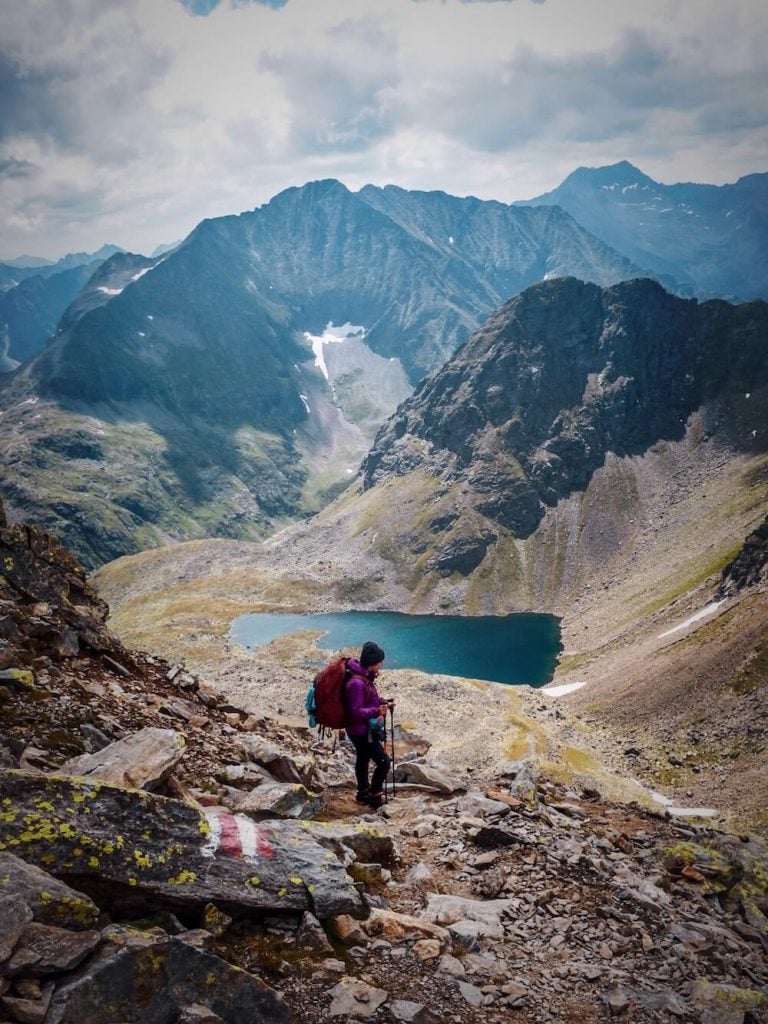
Hochwurzen Cableway Mountain Station to Giglach Lakes (6:30 hours)
This segment of the tour is called Höhenweg Giglach, or Giglach High Trail.
The traditional starting point for the Schladminger Tauern High Trail is Hochwurzen, accessible by the Gipfelbahn Hochwurzen cableway.
The Hochwurzen Cableway Valley Station is located in Rohrmoos, the plateau above Schladming. If you’re staying in the Schladming town center, you can either take a bus, or a taxi to the cableway valley station (20 minutes).
If you’re arriving in Schladming via train, you can hop on a bus to Hochwurzen Gipfelbahn Talstation, directly from the Schladming train station (16 minutes). Check schedule here.
From Hochwurzen, there are sweeping views of the Dachstein massif.
The Giglach High Trail passes several beautiful lakes, including Klammsee and Brettersee.
The final stretch of the hike offers epic views of the Giglachseen lakes. As you descend further, you’ll see the mountain hut Ignaz-Mattis Hütte (1,986 m).
Poor Weather Alternative: Ursprungalm to Giglachseen
There is a shorter way to reach the Giglach Lakes if needed. Take a bus from Schladming, or Rohrmoos to Ursprungalm (1604 m). These buses have limited departures, so plan ahead.
The 3.3 km hike from Ursprungalm to the Giglachseen (Giglach Lakes) takes 1 hour. These two mountain lakes are a popular destination for day hikers, so you’ll see more people on this segment of the trail than any other.
You’ll first arrive at Giglachsee Hütte (1950 m). Follow the trail for another 20 minutes to Ignaz-Mattis Hütte.
Stay in Giglachseehütte, or Ignaz-Mattis Hütte

Giglachseehütte (1950 m) is located close to Oberer Giglachsee (Upper Giglach Lake).
Ignaz-Mattis Hütte (1986 m) is perched above Unterer Giglachsee (Lower Giglach Lake). This is where we stayed. The mountain hut has a sunny terrace with heart-expanding views of the Lower Giglach Lake.
The interior is rustic, warm, and cozy. We slept in the lager (dormitory), which was really comfortable. The food was excellent!

Schladminger Tauern High Trail Stage 2: Giglach Lakes – Keinprechthütte
Stage 2 Trail Stats
Distance | 6.3 km
Time Needed | 3:30 hours
Elevation Gain | 564 meters
Elevation Loss | 690 meters
Difficulty | Moderately Difficult
Minimum Elevation | 1853 meters
Maximum Elevation | 2453 meters
Route | Giglachseen (1921 m) – Rotmandlspitze (2453 m) – Keinprechthütte (1872 m)
Lunch Option | None. Bring a snack, or request a packaged lunch at Ignaz-Mattis Hütte, or Giglachseehütte. The stage is quite short, so you can also eat lunch at Keinprechthütte.
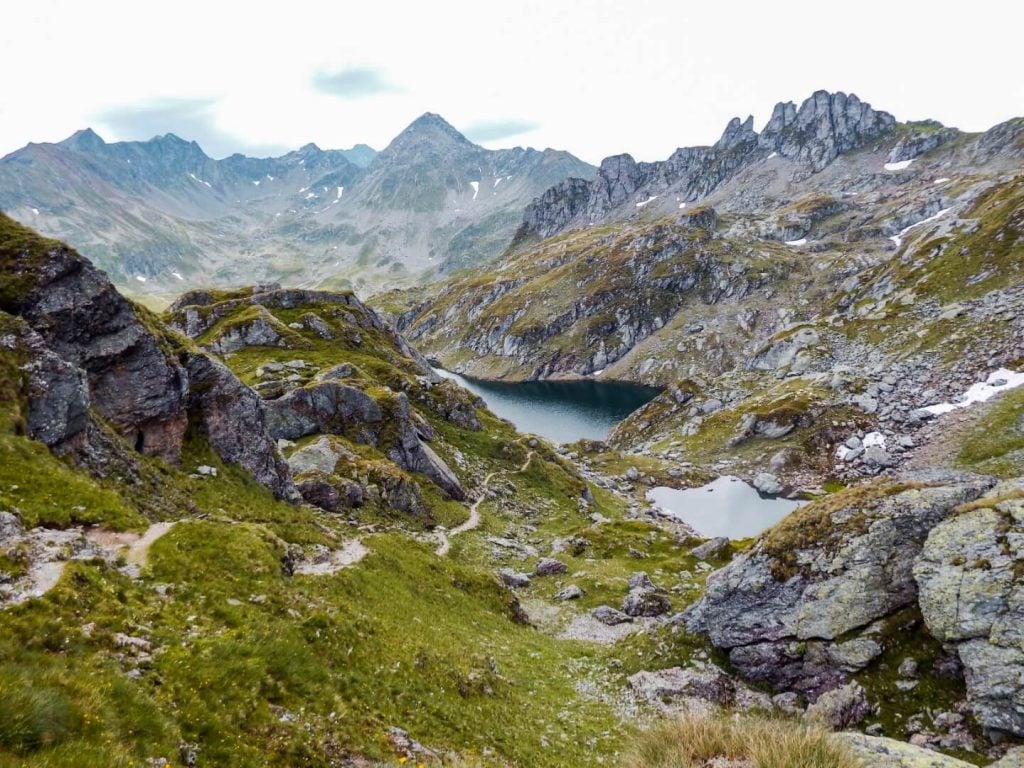
Giglachseen – Rotmandlspitze – Keinprechthütte (3:30 hours)

The Schladminger Tauern High Trail continues to the eastern end of the Lower Giglachsee Lake, past a few unmanaged wooden huts. The trail then begins the ascent to Rotmandlspitze peak (2,453 m).
After traversing scree and a series of switchbacks, you’ll summit the peak. The trail then quickly descends to the perfectly situated Keinprechthütte, which is located in an alpine cirque.
We hiked day 2 in rain and fog. Given the slippery rocky terrain, it was a very difficult hike. Though our views were obscured most of the day, we were able to make out our destination during the final stretch.
Rock-walls form the dramatic backdrop of Keinprechthütte (1872 m). Horses dot the high meadow surrounding the hut. The wooden hut looks like something out of a storybook.
Stay in Keinprechthütte

Lovely, warm and cozy. We slept in the lager, which was very comfortable. Keinprechthütte (1872 m) also offers private rooms. There are free charging areas in the sleeping quarters.
The hut owner and staff were extremely convivial. We spent the evening eating and playing games with fellow hikers in the dining area (Gastzimmer). The Gastzimmer has 6 large wooden tables and encourages visitors to relax and engage in conversation.
The food was exceptional. For dinner, we ate the Bergsteiger meal, goulash, and Kaiserschmarrn.

Schladminger Tauern High Trail Stage 3: Keinprechthütte – Gollinghütte
Day 3 requires stamina since you have to hike over two mountains. Luckily there’s a mountain hut in the middle of the trek, where you can take a break and eat a yummy lunch on a sunny terrace.
Stage 3 Trail Stats
Distance | 9.1 km
Time Needed | 6 – 6:30 hours
Elevation Gain | 930 meters
Elevation Loss | 1114 meters
Difficulty | Moderately Difficult
Minimum Elevation | 1663 meters
Maximum Elevation | 2326 meters
Route | Keinprechthütte (1872 m) – Trockenbrotscharte (2237 m) – Landawirseehütte (1985 m) – Gollingscharte (2326 m) – Gollinghütte (1651 m)
Lunch Option | Landawirseehütte
Keinprechthütte to Gollinghütte (6:30 hours)

After departing Keinprechthütte, the trail begins to ascend ever so gently. We passed a number of grazing cows, before starting the vigorous climb to Trockenbrotscharte (2237 m) ridge.
At Trockenbrotscharte, you can see the welcoming sight of Landawirseehütte as well as the two lakes situated above the hut in an alpine cirque. The descent to the hut is relatively easy.

After a filling meal of Bauernpfandl (Farmer Pan – egg, potatoes, sausage) at Landawirseehütte (1985 m), we decided to take a detour to see the Unterer and Oberer Landawirseen lakes (also spelled Landawierseen). Allow an extra 45 minutes for this detour.
The Schladminger Tauern High Trail continues to Gollingscharte.
After following the wide dirt road from the hut for about 15-20 minutes, you’ll veer left and start the second steep climb of the day to Gollingscharte saddle (2326 m).
At Gollingscharte, you have the opportunity to hike all the way to the top of Hochgolling (2862 m).
At Gollingscharte, we took a 20-minute break, before starting the long descent through scree to Gollingwinkel.
When the trail finally plateaus, you’ll arrive in Gollingwinkel, a glorious natural amphitheater at the foot of Hochgolling’s north face.
Next, the trail continues through a meadow and along a river to the Gollinghütte mountain hut. The flat grassy footpath feels like heaven beneath your feet.
Stay in Gollinghütte

Located on a river, the charming Gollinghütte is a busy mountain hut that is situated at the crossroads between the Schladminger Tauern High Trail and the valley trail that leads to Schladming in 4:30 hours (or Parkplatz Riesachfall in 2 hours).

Schladminger Tauern High Trail Stage 4: Gollinghütte – Preintalerhütte
Each day of the Schladminger Tauern High Trail is glorious, but day 4 might be the most impressive. After climbing to the summit of Greifenberg, you’ll descend into Klafferkessel, a high alpine plateau dotted with 30 mountain lakes
Stage 4 Trail Stats
Distance | 7.7 km
Time Needed | 6 – 6:30 hours
Elevation Gain | 1032 meters
Elevation Loss | 1024 meters
Difficulty | Difficult
Minimum Elevation | 1646 meters
Maximum Elevation | 2618 meters
Route | Gollinghütte (1651 m) – Greifenberg (2618 m) – Klafferkessel (2311 m) – Preintalerhütte / Waldhornalm (1656 m)
Lunch Option | None. Bring a snack, or request a packaged lunch at Gollinghütte.
Gollinghütte to Preintalerhütte (6:30 hours)

The trail gets down to business in no time. Before you know it, you’re climbing uphill for three hours.
The unrelenting trail plateaus at Greifenbergsattel, where there’s a small lake at the mountain saddle. We took a break here before tackling the final stretch to the top of Greifenberg.
Greifenberg peak (2618 m) is marked by a large cross. From the summit, you’ll have terrific views of the water-inundated landscape of Klafferkessel.
The rocky descent is a bit tedious, but you’ll soon arrive in an alpine wonderland full of lakes of varying sizes. This unique landscape is a relic of the Ice Age.

The trail continues along numerous pools of water, offering a visual paradise and a respite for tired legs. Eventually, the trail nears the edge of the tarn landscape and plummets in the direction of Preintalerhütte.
Preintalerhütte (1656 m) is located next to the dairy farm Waldhornalm. For those who want to try fresh buttermilk, Waldhornalm is the place to indulge.
Stay in Preintalerhütte

Located next to the river and overlooking a valley, Preintalerhütte (1656 m) is a large mountain hut, which marks the last night of the 5 stage journey.
We arrived in Preintalerhütte and immediately treated ourselves to Kuchen (cake) and Kaffee (coffee). Their Nuss-Schoko Kuchen and Apfelstrudel were both excellent.
We spent the afternoon relaxing in the sun across Waldhornalm. The rustic wooden hut serves fresh dairy products as well as snacks.
Dinner here was excellent. We tried the Käsespätzle with regional Styrian cheese as well as Schweinsbraten. Yum!

Schladminger Tauern High Trail Stage 5: Preintalerhütte – Planai Seilbahn Mountain Station
Stage 5 of Schladminger Tauern is also called the Planai Höhenweg. It’s indeed a high trail. If you’re scared of heights or have trouble with exposure, head back to Schladming through the valley.
Many areas of the trail are secured with steps and ropes, but some areas could use some more assistance.
It’s dramatic, it’s challenging, and it’s long.
The hike ends with a cableway descent from Planai to the Schladming town center. Check Planai Seilbahn summer opening times.
Stage 5 Trail Stats
Distance | 11.3 km
Time Needed | 7 – 7:30 hours
Elevation Gain | 1125 meters
Elevation Loss | 973 meters
Difficulty | Challenging
Minimum Elevation | 1663 meters
Maximum Elevation | 2266 meters
Route | Preintalerhütte (1656 m) – Neualm – Spielbühel (2210 m) – Planai Seilbahn Mountain Station (1906 m)
Lunch Option | None. Bring a snack, or request a packaged lunch at Preintalerhütte. We ate at the very end of the stage at Schafalm, close to the Planai Seilbahn Mountain Station.
Planai High Trail: Preintalerhütte to Planai Seilbahn Mountain Station (7:30 hours)

It’s important to start the hike early. We suggest starting no later than 7:30 am. The last gondola down to Schladming is at 5 pm and you absolutely don’t want to rush the last 2 hours of the trail.
After 1:30 hours, you’ll reach Neualm, a high alpine meadow with a deserted mountain hut and view of Riesachsee lake.
The hike continues uphill for a few hours and plateaus at Spielbühel (nice place for a break). Unlike the previous days, there’s more variance in the ascent, so you’re not going uphill continuously.
After Spielbühel (2210 m), you’ll descend and then follow the footpath just below the ridge.
The views of the valley and mountains remain mostly constant. As the trail progresses, you’ll see the imposing peaks of the Dachstein massif.
The last segment of the trail is on a wide, even path. Eventually, you’ll reach an intersection, where you can go right or left via the Panorama-Weg to the Planai Mountain station (1906 m).
When you finally reach Planai, you can celebrate your success with lunch and a Schnaps at Schafalm.
Remember that the gondola that connects Planai with Schladming closes at 5 pm.
Stay in Schladming
Budget-Midrange | TUI BLUE Schladming
Midrange-Luxury | Thalers Mariandl
Luxury | Stadthotel Brunner
Look for accommodation in Schladming.

Explore Styria
- Schladming Summer Hiking Guide
- Skiing in Schladming Ski Resort
- 5 Huts Trail in Ramsau am Dachstein
- Bachlalm to Neustadtalm Circuit Hike
More Hut to Hut Hiking Trails
Austria:
- Best Treks in Austria
- Emperor’s Crown (Kaiserkrone) Trek
- Rätikon High Trail
- Montafon Hut to Hut Circuit
- Eagle Walk
- Berlin High Trail
- Karwendel High Trail
- Venediger High Trail
Slovenia:
- Hut to Hut Hiking in Slovenia
- Mountain Huts in Slovenia
- Triglav National Park Hut to Hut Hike, Slovenia
- Kamnik Alps Hut to Hut Hike, Slovenia
Italy:
- Hut to Hut Hiking in the Italian Dolomites
- Alta Via 1 Trek, Italian Dolomites
- Tour du Mont Blanc Trek: France, Italy and Switzerland
- Ortler High Trail, Italy
Europe:

Pin this Image for Future Trip Planning!
Stay Connected:
Connect with us on Pinterest.
Follow us on Instagram.
Like us on Facebook.
Support Us:
If you love reading our content, you can buy us a coffee via Ko-Fi.
