The Eagle Walk (Adlerweg in German) is a long-distance hut-to-hut hiking trail that traverses the Austrian State of Tirol in 33 stages, from East to West.
In North Tirol, the hiking trail starts in St. Johann in Tirol and ends in St. Christoph am Arlberg (Stages 1 – 24). The trail continues for another nine stages in East Tyrol (Osttirol), Austria.
While some may want to hike the Eagle Walk in its entirety, others may want to hike a section, choosing a specific mountain range.
In North Tirol, the Eagle Walk crosses the Wilder Kaiser, Brandenberger Alps, Karwendel, Tux Alps, Wetterstein Mountains, and Lechtal Alps.
In Osttirol, the Eagle Walk cuts across the Hohe Tauern Range, starting in the Venediger Group and ending in the Grossglockner Group. This route overlaps somewhat with the Venediger High Trail.
We wrote this Eagle Walk trekking guide based on our personal experience. Keep in mind that things can change over time: trail difficulty, accessibility, and routing (due to rock falls, landslides, and avalanches) and hut management (reservation system, hospitality, payment, food quality, etc…). Please do your due diligence before tackling this route.
Update 2024 | Due to renovation work the Württemberger Haus is closed in 2024.
- When to Hike: July, August, or September
- Where to Stay: Mountain Huts only.
- How to Book the Berlin High Trail: Independently. Instructions below. If you want to book a self-guided trek, check out these alternative trails: 6-Day Hut to Hut Light in the Austrian Alps (kid-friendly), 8 Day Culinary Delight Hut Hiking Tour, and 3 Day Culinary Delight Extended Weekend Hiking.
- Overnight Hut Discounts: Discounts are administered to guests with Alpine Club ID cards on which the logo of the reciprocal rights agreement is printed. Learn more about alpine club membership in Tips for Hiking in the Alps.
- What to Pack: Cash, sleeping bag liner (e.g. Sea to Summit liner). Read our Hut to Hut Hiking Packing List.
- Trail Map: Lechtaler Alpen WK 351
- Guidebook: The Adlerweg – Cicerone Guide
- Tips for Hut Hiking in Austria: Read Hut to Hut Hiking in Austria: Essential Tips and Visiting Austrian Mountain Huts
- Where to Stay before the Trek: Ferienwohnung Sonja (budget), Pension Elmerhof (budget), or LechZeit (luxury) in Elmen, Lech Valley
- Where to Stay after the Trek: Lech Hostel (budget), or Hotel Garni Schneider (midrange) in Lech am Arlberg
Eagle Walk Lechtal Alps Hiking Map
TREK STAGES
Where to Stay
Day 1
Day 2
Day 3
Day 4
Day 5
Day 6 to St. Anton
Days 6-7 to Lech
Day 6 to St. Christoph
Eagle Walk Lechtal Alps Hiking Trail Difficulty
Very Difficult.
This challenging 6-day trek across the Lechtal Alps is suitable for experienced alpine hikers who are sure-footed, in excellent physical condition, have lots of stamina, and are not afraid of heights.
You need to be able to navigate extremely narrow, washed-out trails as well as exposed ridges.
You should have a few hut-to-hut hikes under your belt as well. There are some “Holy Hell” moments along this trail, and you need to be physically and mentally prepared.
Please do not email me, asking “Is it really that hard? I hiked the TMB.”
No special equipment is needed for this hike. But, we strongly recommend packing Black Diamond Climbing Gloves and Unisex Black Diamond Hiking Poles.
If you’re interested in easier hut-to-hut hikes, please read Best Treks in Austria.

Eagle Walk Lechtal Alps Stages 19 – 24
We decided to tackle the Eagle Walk stages across the Lechtal Alps (19 – 24) – basically the most grueling section of the Adlerweg – because we’re partial to jagged limestone peaks, wildlife, and remote hiking trails.
Our interest was further peaked by the intimidating descriptions of these stages. In a somewhat concerned voice, I told Kati that this trail would be “very difficult” and she replied haughtily “How difficult can it really be?”
Well, it was very difficult – more so than we anticipated!! It was also the most riveting and mesmerizing trail we’ve hiked in the Austrian Alps. Scenically, the views are hard to rival.
Additionally, while traversing the Lechtal Alps, you’ll also have heart-stopping views of the crystalline Verwall mountain range, a dazzling contrast to the limestone Lechtal range.
From a flora and fauna perspective, the Eagle Walk rewards hikers with daily wildlife sightings and a plethora of wildflowers. We saw roaming ibex, chamois, and marmots daily. And the cherry on top is the solitude. On any given day, we saw no more than 10 other hikers on the trail, traveling in the opposite direction.
6-Day Lechtal Alps Trekking Itinerary
Day 1 (Stage 19) | Boden – Hanauer Hütte (5.3 km, 2 hours)
Day 2 (Stage 20) | Hanauer Hütte – Steinseehütte – Württemberger Haus (11 km, 7 hours)
Alternative Day 2 | Hanauer Hütte – Gufelsee – Bittrichsee – Württemberger Haus (9.7 km, 6 hours)
Day 3 (Stage 21) | Württemberger Haus – Memminger Hütte (7 km, 5 hours)
Day 4 (Stage 22) | Memminger Hütte – Ansbacher Hütte (10 km, 6 hours)
Day 5 (Stage 23) | Ansbacher Hütte – Kaiserjochhaus – Leutkircher Hütte (12.7 km, 7 hours)
Day 6 (Stage 24) | Leutkircher Hütte – St. Christoph am Arlberg (12.3 km, 5 hours)
Alternative Day 6 | Leutkircher Hütte – St. Anton am Arlberg (7.2 km, 2:30 hours)
Alternative Days 6 and 7 | Leutkircher Hütte – Stuttgarter Hütte – Lech am Arlberg (2 Days)
Eagle Walk Alternative Routes
Day 1 (Stage 19) starts at Anhalter Hütte, however, our trek begins halfway through Stage 19 at Boden.
Day 2 (Stage 20). There are a few ways to hike from Hanauer Hütte to Württemberger Haus. We decided to hike the shorter way via Gufelseejoch and Bitterscharte instead of via Steinseehütte, because of the weather forecast. This is a gorgeous alternative route, which is considerably easier than the Steinsee trail.
Day 6 (Stage 24) of the Eagle Walk is anti-climatic and a bit disappointing. If we could do it again, we’d either descend directly to St. Anton am Arlberg from Leutkircher Hütte, or we’d add an extra day, overnighting in Stuttgarter Hütte and descending on Day 7 to Lech am Arlberg (in Vorarlberg) via the Rüfikopfbahn.

How to Book the Eagle Walk Hut-to-Hut Trail
All mountain huts along the Eagle Walk must be booked individually and independently.
It’s important to make reservations for overnight stays in huts several months in advance. You may be able to book more short-term, if you have a flexible start date.
You can make overnight reservations for most huts along the Berlin High Trail using the Huetten Holiday or Alpsonline online reservation platform.
For more information about booking huts, read our guide to visiting Austrian Mountain Huts. For information about pricing, hut etiquette, joining the Austrian Alpine Club, helpful German phrases to know for hiking in Austria, read hut to hut hiking in Austria.
Arrival Day | Stay in Elmen, Lech Valley: Ferienwohnung Sonja (budget), Pension Elmerhof (budget), or LechZeit (luxury).
Stage 1 | Hanauer Hütte – Online Reservation via huetten-holiday.com
Stage 2 | Württemberger Haus – Online Reservation via Alpsonline (Closed in 2024)
Stage 3 | Memminger Hütte – Online Reservation via Alpsonline
Stage 4 | Ansbacher Hütte – Online Reservation via huetten-holiday.com
Stage 5 | Leutkircher Hütte – Online Reservation via huetten-holliday.com
Optional – Stage 6 | Stuttgarter Hütte – Online Reservation via Alpsonline
Departure Day | The trek ends in St. Christoph am Arlberg, in St. Anton am Arlberg, or at the Rüfikopfbahn Mountain Station above Lech. We recommend staying in Lech am Arlberg: Lech Hostel (budget), Hotel Garni Schneider(midrange), Hotel Gotthard (luxury), or St. Anton am Arlberg: Pension Haus Gamberg (budget), m3Hotel (midrange), Hotel Ullrhaus (luxury).
Luggage Transfer | Use Feuerstein to transfer your luggage from your Lech Valley accommodation (ours was LechZeit in Elmen) to your final (hotel) destination in St. Anton am Arlberg, or in Lech am Arlberg. Ours was Hotel Gotthard in Lech.

Arrival Day in Elmen in Lech Valley
How To Get to Elmen
To get to Elmen (976 m), it’s best to start your journey in Munich or Innsbruck.
From Munich, take a train to Reutte in Tirol, where you switch to Bus 110 to get to Elmen. The whole trip will take around 3:30 hours.
From Innsbruck, either travel to Elmen via Nassereith and Reutte in Tirol, or go through Lech am Arlberg in Vorarlberg. It also takes around 3:30 hours.
Where to Stay in Elmen, Lechtal Valley
Budget | Ferienwohnung Sonja
Budget | Pension Elmerhof
Luxury | LechZeit is a stylish, alpine-modern hotel and restaurant in Tiroler Lech Nature Park. With its mature millennial vibe, rooms feature sophisticated and functional minimalism that we found really appealing. We wouldn’t mind moving in. Rooms either face the valley, framed by the Lechtal Alps, or the forest.
The hotel’s restaurant is a very popular place in the Lech Valley, so make sure to make a dinner reservation in advance. Serving sumptuous and traditional Tyrolean cuisine, it’s tempting to overeat. We had a great experience, and we hope we can return soon.
Look for accommodation in Elmen.

Eagle Walk Day 1 (Stage 19): Boden – Hanauer Hütte
Stage 19 Trail Stats
Distance | 5.3 km
Time Needed | 2:30 hours
Elevation Gain | 579 meters
Elevation Loss | 9 meters
Difficulty | Moderate
Minimum Elevation | 1348 meters
Maximum Elevation | 1921 meters
Route | Boden (1357 m) – Hanauer Hut (1922 m)
Lunch Option | None. The stage is very short, so you can eat lunch at Hanauer Hut when you arrive.
How to Get to the Boden Trailhead
Take the Linientaxi from Elmen Gemeindeamt to Boden Dorf (20 minutes), which operates Thursdays through Sundays. The shuttle only leaves once in the late morning, and twice in the afternoon. This is free with the Lechtal Aktiv Card, which you receive for free when staying at LechZeit.
If you’re starting the trek on a Monday, Tuesday, or Wednesday, you’ll need to organize your own transit to Boden. Reach out to Klugi’s Shuttle Service +43 (0) 676 557 80 18 (or: + 43 (0) 5635 554), or ask LechZeit to help arrange the transfer for you.
Boden to Hanauer Hut (2:30 hours)
Stage 19 of the Eagle Walk begins at Anhalter Hütte. Since we’re entering the trail in Boden (half-way through the stage), it doesn’t make sense to backtrack to Anhalter Hütte.
From the shuttle-drop-off point at Boden, follow signs to Hanauer Hütte (signed 2:30 hours). After crossing the bridge over Fundaisbach stream, follow the road to the parking lot.
From the parking area, the trail continues over another bridge and then heads left up the valley, parallel to Gstreinbach stream.
As you follow the wide gravel track through the valley, you’ll amble across green-carpeted forests. Listen to the birds and enjoy the flat walking.
After 3.4 km, the wide track ends at the bottom of the Seilbahn, the cable car that services the mountain hut. From here, the “hiking trail” begins. You’ll ascend 390 meters to Hanauer Hütte (1922 m) rather quickly.
Stay in Hanauer Hütte
We liked the location and the rooms of Hanauer Hütte (1922 m). From the outdoor terrace, there are unobstructed views of Dremelspitze, Parzinnspitze, Plattigspitze, Schlenkerspitze.
Reservation | Hanauer Hütte – Online Reservation via huetten-holiday.com
Payment | Cash only
Showers | 4 EUR for 3 Minutes, Token operated. Open from 4 pm.
Drinking Water | Tap water is safe to drink
Electronic Charging Stations | Dining room and in bedrooms
Food | Okay
Half Board or à la carte | We recommend choosing à la carte.
Rooms | Dormitory, and private rooms

Eagle Walk Day 2 (Stage 20): Hanauer Hütte – Württemberger Haus
Stage 20 Trail Stats
Distance | 8.9 km
Time Needed | 6 hours
Elevation Gain | 1052 meters
Elevation Loss | 749 meters
Difficulty | Moderate. The only difficult part of this hike is the ascent to Bitterscharte. It’s steep and the final stretch is almost vertical, but luckily it’s secured with cables
Minimum Elevation | 1912 meters
Maximum Elevation | 2547 meters
Route | Hanauer Hütte (1922 m) – Unterer Parzinnsee – Gufelseejoch Saddle – Gufelsee – Bitterichsee – Bitterscharte Notch – Württemberger Haus (2220 m)
Lunch Option | None. Pack a snack, or request a lunch packet from Hanauer Hütte.
Hanauer Hütte – Bitterscharte – Württemberger Haus (6 hours)
We decided to hike the alternative route because the weather forecast predicted rain and thunderstorms. This route is spectacular, and because it’s “less-traversed,” we saw roaming chamois and ibex throughout the day.
Starting at Hanauer Hütte, follow signs to Württemberger Haus, in the direction of Gufelseejoch. This gorgeous trail ascends through a vibrant, alpine paradise blooming with yellow kidney vetch, fuchsia alpenrose, and violet ferry’s thimble.
From the wooden Parzinnalmhütte, continue hiking up to Unterer Parzinnsee (Lower Parsinn Lake), a small, nearly dried-out lake below Parzinnspitze.
The trail continues up and then left to Gufelseejoch, diagonally crossing a slope. Twisting hairpins and one steel cable guide you to Gufelseejoch, the saddle between Parzinnspitze and Kogelseespitze.
From the saddle, you’ll see Gufelsee below. Descend the loamy trail (very slippery in wet conditions) to the lake.
After passing the lake, the trail slowly descends across grassy slopes, animated by running and whistling marmots.
The trail eventually levels out, and you’ll walk across a meadow, cross a stream, and follow a balcony trail around Vorderer Gufelkopf above Glabtal.
When you reach an intersection, turn right towards Württemberger Haus über Bitterscharte (signed 3 hours). With views of the Otterbach river and the valley leading to Gramais village, the trail begins to ascend towards Bitterichsee.
Off to your left, you’ll see the tiny unmanned Gufelhütte.
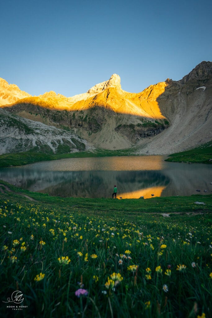
In July, the Bitterichsee lake was ringed with kidney vetch, which looked like a vivid yellow carpet. We took a long break here, soaking our feet in the water and enjoying the solitude.
From the lake, you have to cross the Otterbach stream, as the trail continues on the right side of the lake. We didn’t find a good crossing point, so we took off our shoes and crossed with our crocs.
Rising steadily above Bitterichsee, the views just get better and better. Look for ibex around here.
The trail eventually turns left along the Stuttgarter Weg and steeply ascends a scree slope. The final stretch to the Scharte (notch) is secured with steel cables. You’ll need both hands and some strength to navigate this very steep section.
When you reach Bitterscharte, you’ll descend towards Württembergerer Haus (2220 m). Luckily, this side of the notch is less steep, so the hardest part is behind you.
As you descend, the views of Auf der Lacke and the soaring peaks behind the lake – Östliche Spiessrutenspitze, Westliche Spiessrutenspitze, Plankenspitze – will take your breath away.
We wanted to linger, but our descent was hastened by an unfriendly hail storm.
Soon the trail merges with the one from Steinseehütte, and it’s a final 1/2 kilometer (130 m descending) to the mountain refuge.
Stay in Württemberger Haus
Facing the distant Ötztal Alps and hovering over a stream, Württemberger Haus (2220 m) occupies one of the most romantic locations in the Lechtal Alps, high above Zams.
This hut is cozy, warm, and absolutely charming. There’s limited space here, so the sleeping quarters are tighter. But, that doesn’t matter at all, because the outdoor terrace and the interior dining area invite you to relax and unwind.
There’s a lot to praise about this hut. The management creates a stress-free environment – there aren’t 101 rules to adhere to – and the food is superb and served in generous portions.
Reservation | Württemberger Haus – Online Reservation via Alpsonline (Closed in 2024)
Payment | Cash Only
Showers | No hot showers. There’s a cold shower outside.
Drinking Water | Tap water is safe to drink
Electronic Charging Stations | Limited places to charge your devices.
Food | EXCELLENT
Half Board or à la carte | Both options are available. You can decide what you want when you arrive (by 5 pm).
Rooms | Dormitory and private rooms

Eagle Walk Day 3 (Stage 21): Württemberger Haus – Memminger Hütte
Stage 21 Trail Stats
Distance | 7 km
Time Needed | 5 hours
Elevation Gain | 670 meters
Elevation Loss | 650 meters
Difficulty | Difficult
Minimum Elevation | 2200 meters
Maximum Elevation | 2635 meters
Route | Württemberger Haus (2220 m) – Grossbergspitze Peak (2635 m) – Grossbergkopf Mountain (2612 m) – Grossbergjoch Saddle – Seescharte Notch (2599 m) – Unterer Seewisee – Memminger Hütte (2242 m)
Lunch Option | None. Request a packed lunch, or bring a snack.
Württemberger Haus – Grossbergspitze – Memminger Hütte (5 hours)
Stage 21 of the Eagle Walk is equal parts fun and demanding, requiring you to carefully climb along a lengthy ridge. This is a true Höhenweg (High Trail). You’re practically dancing in the clouds.
From the Württemberger Haus, set out in the direction of Östliche Spiessrutenspitze. At first, the trail gently ascends, crossing grassy slopes before leading you to a scree slope.
The trail gets increasingly steeper, eventually twisting tightly and then not twisting at all – it’s just straight up (and it burns like hell) – bringing you to a rock wall.
Less steep than before, the path continues along longer switchbacks. Some iron rungs and a rope help you ascend and then you’ll follow a nice path to the ridge.
From the ridge, continue climbing up to Grossbergspitze Peak (2635 m). Take a break here.
From the peak, the trail gets technically more difficult. There are some tricky, narrow parts that require your full attention. Follow the ridge to Grossbergkopf (2612 m). It feels like you’re walking along the spine of the mountain.
Part of the exposed route is secured, but not all of it.
When you reach Grossbergkopf, the trail continues on the left side of the ridge, and you’ll slowly descend.
The trail levels and you’ll cross grass and scree slopes horizontally. This is easy and painless. When you reach a trail intersection, Memminger Hütte is signed (2 hours). The other sign points down to Zams.
Continue ascending to the very-tight Seescharte Notch (2599 m). When you squeeze through, you’ll see several alpine lakes and Memminger Hütte.
From Seescharte, the descent is initially secured. Then you’ll continue hiking steeply down scree, talus, and earthy soil. The path follows the Seewissebach stream and you’ll hike down a little ravine.
It’s a great relief when you reach the level ground and see the meadows around Unterer Seewisee. The trail divides, and you can walk around the lake to the hut in either direction.
We chose the right path and found a pleasant place to rest by the lake. Memminger Hütte (2242 m) is only a few minutes away.
Optional Peak Hike to Seekogel (2412 m)
From Memminger Hütte, you can hike to Seekogel, the peak overlooking the hut. We hiked to Seekogel in the late afternoon, after eating cake and coffee at the hut, and decided we wanted to return for sunrise.
The next morning we hiked again to Seekogel. Please don’t be as stupid as us. You don’t need to add any more hiking to Stage 22.
Trailhead | Memminger Hütte
Distance | 1.6 km out-and-back
Time Needed | 1 hour
Elevation Gain/Loss | 170 meters
Difficulty | Moderate
Stay in Memminger Hütte
Memminger Hütte (2242 m) is situated in a bowl encircled by magnificent peaks. There’s grandeur to this location that can’t be overstated. It’s EPIC!
The E4, E5, Lechtal High Trail, and the Eagle Walk all intersect at Memminger Hütte. E5 is basically the “Camino of the Alps” and a bucket-list adventure for every German hiker. This was the only place along our trek that felt a bit overrun.
So, it’s a bit crowded and has an impersonal, big hut vibe. However, the staff does an excellent job managing everything. We never waited very long to order food or drinks. And, our experience was overall quite good.
Reservation | Memminger Hütte – Online Reservation via Alpsonline
Payment | Cash Only
Showers | 4 EUR for 3 Minutes, token operated
Drinking Water | Tap water is safe to drink
Electronic Charging Stations | dining room, limited outlets in rooms
Food | Very Good
Half Board or à la carte | Both available
Rooms | Dormitory and shared rooms (4+ people / room)

Eagle Walk Day 4 (Stage 22): Memminger Hütte – Ansbacher Hütte
Stage 22 Trail Stats
Distance | 9.7 km
Time Needed | 6 hours
Elevation Gain | 1040 meters
Elevation Loss | 900 meters
Difficulty | Difficult
Minimum Elevation | 1740 meters
Maximum Elevation | 2620 meters
Route | Memminger Hütte (2242 m) – Griesslscharte Notch – Winterjoch Saddle – Kopfscharte Notch – Ansbacher Hütte (2376 m)
Lunch Option | None. Request a lunch packet at Memminger Hütte
Memminger Hütte – Griesslscharte – Ansbacher Hütte (6 hours)
From Memminger Hütte, the trail descends left along a loamy track across sloping terrain in the direction of Parseiertal Valley. After a water crossing, the trail narrows and is secured by a system of cables.
You’ll continue along this narrow singletrack trail, crossing more streams, before finally reaching Parseierbach stream.
From Parseierbach, the 910-meter ascent to Griesslscharte begins. The trail ascends up a grove, in the direction of a tiny private hut wedged into the rock above.
Before reaching the hut, the trail turns sharply left. You’ll continue hiking up grassy slopes, along a moderate trail to Langkar cirque.
The easy part is over. On the right side of the cirque, the trail continues straight up. It’s an unforgiving uphill battle, especially on hot days.
The track eventually crosses the rubble-filled cirque over a snowfield, bringing you to the bottom of a secured passage. The fixed cables help you ascend quickly to the notch.
When you summit Griesslscharte, celebrate yourself and your beautiful, strong and healthy body!!
From Griesslscharte, it’s mostly easy-going from here, though you still have to hike 3.4 km to reach the hut.
You’ll descend scree terrain into a “bowl” where some snow resides until late summer. The mountain views are extraordinary. Colors collide and the peaks look like they are melting and congealing at the same time.
From Winterjoch, you’ll hike horizontally across scree slopes behind Stierkopf, until making a final climb to Kopfscharte Notch. After this final ascent, you’ll plateau and follow a soft, grassy, heavenly trail to Ansbacher Hütte.
This stage ends splendidly with sweeping views of the Verwall mountain range on the other side of the Stanzer Tal Valley.
You’ll also see the town of Flirsch below, cradled by two impressive ranges. As you follow the balcony trail to the Ansbacher Hütte (2376 m), you’ll likely encounter some grazing sheep or at least their lasting evidence.
Stay in Ansbacher Hütte
This traditional Ansbacher Hütte (2376 m) combines delicious food with equally delicious views.
Reservation | Ansbacher Hütte – Online Reservation via huetten-holiday.com
Payment | Cash only
Showers | 1 EUR for 1 Minutes, 1 EUR coin-operated
Drinking Water | Tap water is safe to drink
Electronic Charging Stations | Sporadic, not very many
Food | Very Good
Half Board or à la carte | Both available. We had the half board menu and it was excellent.
Rooms | Private and Dormitory

Eagle Walk Day 5 (Stage 23): Ansbacher Hütte – Leutkircher Hütte
Stage 23 Trail Stats
Distance | 12.7 km
Time Needed | 7 hours
Elevation Gain | 950 meters
Elevation Loss | 1069 meters
Difficulty | Difficult
Minimum Elevation | 2249 meters
Maximum Elevation | 2587 meters
Route | Ansbacher Hütte (2376 m) – Flarschjoch Saddle – Alperschonjoch Saddle – Hinterseejoch – Kridlonscharte – Kaiserjochhaus (2310 m) – Leutkircher Hütte (2251 m)
Lunch Option | Kaiserjochhaus. However, you should pack a snack, because it takes a good 5 hours to reach Kaiserjochhaus from Ansbacher Hütte.
Ansbacher Hütte to Kaiserjochhaus (5 hours)
Stage 23 of the Eagle Walk is a beast of a hike. We found it more challenging than the previous two days because parts of the trail are washed out.
You’ll begin this stage by backtracking along yesterday’s stage for 670 meters. When the trail divides, head left and glide up to Flarschjoch saddle.
From Flarschjoch, you’ll descend and then cross the barren rocky landscape of Knappenböden. You’ll continue across scree slopes to Alperschonjoch Saddle.
The next section requires a bit of patience, as you’ll clamber along 19 secured sections, skirting the rugged, southern side of the Vorderseespitze Spire.
While no special equipment is necessary, we were really happy to have these climbing gloves. This is known as the Haas-Weg Trail. It’s not terribly difficult, but it’s long (1 hour).
Because you’re moving horizontally, you’re not expending a lot of energy.
When you reach Vordersee (above the lake, not directly at the lake), the trail climbs gradually for 200 meters to Hinterseejoch. The final stretch to the saddle steepens along switchbacks.
From the Hinterseejoch, the views of Hintersee lake are enchanting. The initial descent is a bit slippery, because of the falling, earthy-rock terrain.
The trail then hugs the rocky mountain slope leading up to Kridlonscharte, in a soft diagonal line. This part is actually quite difficult because snow-melt carves up the trail.
In some places, it’s so narrow, it’s hard to decide where to put your foot. And, you can’t really grab onto anything for support.
As you near Kridlonscharte, you’ll hike across rugged and exposed terrain, secured with cables. To reach the pass, you’ll climb up a chimney, also secured with fixed cables.
The path levels out on the other side of the Scharte (pass). You’ll follow a balcony path across earthy terrain and then scree. Below, you’ll see the town of Pettneu am Arlberg, and above, the perfectly-pointed Kridlonspitze peak.
You have to cross boulders and then a steep, exposed slope (similar to the Vorderseespitze Spire slopes earlier in the day), along a scant trail, before reaching Kaiserjochhaus.
It’s demanding and it’s a pain-in-the-ass, but it’s almost over. The scrambling ends soon!
When you reach the saddle between Malatschkopf and Griesskopf, you’re almost at Kaiserjochhaus.
Some people stay the night at Kaiserjochhaus (2310 m), which is definitely an option.
After some cake, coffee, and Johannisbeersaft gespritzt, we continued on to Leutkircher hut (2 hours). Luckily, these next two hours are easy.
Kaiserjochhaus to Leutkircher Hütte (2 hours)
From the Kaiserjochhaus (2310 m), you’ll begin by hiking up to the approachable peak Kaiserkopf. From the grassy summit, you’ll descend and then horizontally traverse the grassy slopes of Bergleskopf.
Ascend to Schindelescharte, the saddle between Schindlekopf and Bergleskopf. At the saddle, Leutkircher Hütte is signed (1:15 hours).
You’ll continue descending and crossing the grassy slopes of Bergleskopf until reaching a green basin at the foot of pretty Stanskogel.
This is all very easy walking – thank the heavens!!!
With views of the Verwall on your left, follow the beautiful footpath through lush meadows and pastures.
When you wrap around the mountain, you’ll see Leutkircher Hut (2251 m) below and an ensemble of jagged peaks. It’s a short descent to reach the hut.
Stay in Leutkircher Hut
This 108-year-old Leutkircher mountain hut (2251 m) is what every mountain hut ought to be: friendly, warm, welcoming, and exceedingly charming.
Meinhard Egger has been managing the hut for 30 years and he’s so happy to answer your questions. We loved our stay here and can’t wait to revisit.
Reservation | Leutkircher Hütte – Online-Reservation via huetten-holliday.com
Payment | Cash only
Showers | 3 EUR for 3 Minutes, token operated
Drinking Water | Tap water is safe to drink
Electronic Charging Stations | In the dining room (available until 10 pm)
Food | Very Good
Half Board or à la carte | Both available. You can decide before 5 pm.
Rooms | Private and dormitory

Eagle Walk Day 6 (Stage 24): Leutkircher Hütte – St. Christoph am Arlberg
Stage 24 Trail Stats
Distance | 12.3 km
Time Needed | 5 hours
Elevation Gain | 539 meters
Elevation Loss | 1026 meters
Difficulty | Difficult
Minimum Elevation | 1769 meters
Maximum Elevation | 2550 meters
Route | Leutkircher Hütte (2251 m) – Ulmer Hütte (2288 m) – Galzig – Maiensee – St. Christoph am Arlberg (1765 m)
Lunch Option | Ulmer Hütte
Leutkircher Hütte to St. Christoph am Arlberg (5 hours)
We didn’t love the final stage of the Eagle Walk.
After some very rugged, exposed scrambling, you’ll descend through the St. Anton Ski Resort, which is an eyesore in summer.
The mountain is carved up by ski infrastructure, and it’s jarring. That’s no way to end an epic hike like the Eagle Walk.
Of course, it makes sense that the Eagle Walk ends in St. Christoph am Arlberg (1765 m), the westernmost Tirolean town.
However, we don’t think this stage is worth it.
If we could do it over again, we’d hike to Stuttgarter Hütte and overnight there, before finishing the hike in Lech am Arlberg in Vorarlberg. Alternatively, you could just descend to the valley to St. Anton directly from the hut in 2:30 hours.
Today’s hike isn’t easy. In fact, there’s a grueling section, which requires careful footing, scrambling, and rock-hugging.
After an easy start, the trail divides. Stay to the left, taking the lower high trail. In 1 km the trail divides again. Follow the signs to Ulmer Hütte (black) on Trail 601, taking the right trail.
After some steep switchbacks, it’s time to get intimate with the rocks. The trail is a bit brutal, with washed out sections and falling terrain. There are some fixed cables along the route.
The trail eventually gets easier and you’ll hike across a scree slope and up a rocky outcrop (not difficult) to Mattunjoch Col.
From Mattunjoch, the “ugly part” begins. Continue to Valfagehrjoch Col and follow signs to Ulmer Hütte. We stayed on the road – the trail seemed pointless – and walked down to the hut.
After lunch at Ulmer Hütte (2288 m), the trail bears left in the direction of Galzig Mountain, descending along a stream and passing a playground beforehand. Take the “Panorama Weg” to Galzig, or just continue on the road (easier).
From the Vallugabahn / Galzigbahn mountain station (there’s a café here), the trail follows the “Maienweg” to Lake Maiensee.
Descend through dwarf pine all the way to the lake. From the lake, it’s a short walk to St. Christoph am Arlberg.
Stay in Lech am Arlberg or St. Anton am Arlberg
St. Christoph am Arlberg is a ghost town in summer. We recommend either heading to St. Anton am Arlberg in Tirol or Lech am Arlberg in Vorarlberg to rest, rejuvenate, and dine, before heading home. Check out our Lech am Arlberg summer guide.
Lech Accommodations
Budget | Lech Hostel is a budget-friendly accommodation in Lech am Arlberg, offering clean and cozy single, double, and triple rooms. Guests have access to a shared kitchen and shared lounge. Bathrooms are shared as well. The room rate is unbeatable.
Midrange | Hotel Garni Schneider is a top-rated, affordable bed and breakfast, situated next to Rüfikopfbahn in the center of Lech. Bedrooms are nicely decorated, spotless, and comfortable. Guests also have access to a wellness area (Finnish sauna, steam bath, Kneipp basins, and relaxation room) and free private parking.
Luxury | We stayed in Hotel Gotthard in Lech, which was the perfect ending. This family-run hotel is located in the middle of the village, very close to the bus stops. The wellness and spa area was our saving grace after this trip. And, the cuisine is excellent (Stube Gotthard). The bedroom upholstery is a bit whacky, but everything is clean and tidy. Overall, you’ll feel quite at home here. Don’t forget to try their excellent house beer OMES – which they brew themselves.
Look for accommodation in Lech am Arlberg.
St. Anton am Arlberg Accommodations
Budget | Pension Haus Gamberg
Midrange | m3Hotel
Luxury | Hotel Ullrhaus
Look for accommodation in St. Anton am Arlberg.

More Hut to Hut Hiking Trails
Austria:
- Best Treks in Austria
- Emperor’s Crown (Kaiserkrone) Trek
- Rätikon High Trail
- Montafon Hut to Hut Circuit
- Berlin High Trail
- Schladminger Tauern High Trail
- Venediger High Trail
- Karwendel High Trail
Slovenia:
- Hut to Hut Hiking in Slovenia
- Mountain Huts in Slovenia
- Triglav National Park Hut to Hut Hike, Slovenia
- Kamnik Alps Hut to Hut Hike, Slovenia
Italy:
- Hut to Hut Hiking in the Italian Dolomites
- Alta Via 1 Trek, Italian Dolomites
- Tour du Mont Blanc Trek: France, Italy and Switzerland
- Ortler High Trail, Italy
Europe:

Pin this Image for Future Trip Planning!
Stay Connected:
Connect with us on Pinterest.
Follow us on Instagram.
Like us on Facebook.
Support Us:
If you love reading our content, you can buy us a coffee via Ko-Fi.

Hello! I am using your blog to plan my week trip in Austria for hiking. However, is there any option for us if the Württemberger Haus is closed this summer? Should we combine two hiking days in one to reach Stage 22 or should we plan to bring our own camping gear?
Hi Natalie,
Wild camping is not allowed in Tyrol.
The only option is to hike stage 1 from Boden to Steinsee Hütte, rather than Hanauer Hütte. The next day, you can carry on all the way to Memminger Hütte. That will be a very long and challenging day, but doable in good weather (13.7 km, 7:15 hours minimum, 1481 m elevation gain, 1283 m elevation loss).
All the best,
Sabrina