The Ortler High Mountain Trail is a strenuous 7-day trek in South Tyrol and Lombardy in Northern Italy. This 119.5 km circular hiking route circumnavigates the Ortler Group (aka Ortles Alps), starting and ending at Stelvio Pass.
Opened in September 2018, the Ortler High Mountain Trail invites alpine hikers to marvel at Mount Ortler (3,905 m, 12,812 ft), the highest peak in the Eastern Alps, and many other notable peaks, from various angles. The rewards of trekking this route are many, including:
Peace and Quiet. Very few people know about this trail, and therefore your experience will be solitary and tranquil.
Glacier Views. The Ortler massif boasts almost 100 glaciers.
Rare Wildlife Sightings. Keep your eyes out for Bartgeier (bearded vultures).
Cultural Intersections. The trail begins in Val Venosta (Vinschgau) in Germany-speaking South Tyrol (Südtirol). South Tyrol was part of Austria, before the First World War, so the culture is distinctly Tirolean (Austrian). After the four-day hike in South Tyrol, the trail continues into the Italian-speaking Valtellina in Lombardy. Throughout this Ortler trekking guide, we’ve tried to use both the German and Italian names for each destination.
Gourmet Cuisine. As you’ll be overnighting in both hotels and mountain huts along the route, there are multiple opportunities to eat regional and gourmet food.
Responsible Travel in Stelvio National Park
While you’re hiking in the Ortler Alps, you’re also hiking within a protected area. In Stelvio National Park, please adhere to the following:
- Fires are strictly prohibited.
- Wild camping is strictly prohibited.
- Take all your rubbish with you.
- Respect wild animals and grazing animals and do not disturb them. Keep a safe distance.
- Close fences/gates.
- Drones are strictly prohibited.
Learn more about respectfully visiting Stelvio National Park.
We wrote this Ortler trekking guide based on our personal experience. Keep in mind that things can change over time: trail difficulty, accessibility, and routing (due to rock falls, landslides, and avalanches) and hut management (reservation system, hospitality, payment, food quality, etc…). Please do your due diligence before tackling this route.
- When to Hike: July, August, or September
- Where to Stay: Mountain Huts and hotels. Camping is strictly prohibited in Stelvio National Park.
- How to Book the Ortler High Trail: Independently. If you want to book a self-guided trek, check out these alternative trails: Best of the Dolomites Trek, Alta Via 1 North, Alta Via 1 Central, and Alta Via 1 Classic Route.
- What to Pack: Cash, sleeping bag liner (e.g. Sea to Summit liner). Read our Hut to Hut Hiking Packing List.
Ortler High Mountain Trail Map
ORTLER HIGH TRAIL TREK
Merano
Day 1
Day 2
Day 3
Ortler High Trail Trekking Itineraries
Ortler High Mountain Trail: Complete Route
In order to hike the Ortler High Mountain Trail in its entirety, trekkers need the assistance of a certified hiking guide on Stage 4, to safely guide them across a glacier. You can download a document listing certified guides in Venosta Valley from this Stelvio National Park resource page (click: “Bergführer im Vinschgau”).
Stage 1 | Stelvio Pass to Stilfs/Stelvio (18.5 km, 7:30 hours)
Stage 2 | Stilfs/Stelvio to Düsseldorfer Hütte (17 km, 9 hours)
Stage 3 | Düsseldorfer Hütte to Zufallhütte (14 km, 7:45 hours)
Stage 4 | Zufallhütte to Rifugio Pizzini with glacier crossing (11.5 km, 6:30 hours)
Stage 5 | Rifugio Pizzini to Sant’ Antonio in Valfurva Tal Valley (20.34 km, 8:30 hours)
Stage 6 | Sant’ Antonio to Lago di Cancano (16 km, 8 hours)
Stage 7 | Lago di Cancano to Stelvio Pass (22 km, 8 hours)
Ortler High Mountain Trail: The Highlights
We created this Ortler trekking guide for those that want to take in the highlights of the Ortler High Trail without the glacier crossing. This modified route isn’t technically demanding, but it still requires stamina and good conditioning. Though this is a “softer” version of the Ortler High Trail, it’s nonetheless strenuous.
This modified route requires one chairlift, bus transit, and/or shuttle transfers. We highly recommend Ortler Bus for personal shuttles. Their team is highly professional, punctual, and friendly.
Day 1 | Arrival Day in Trafoi
Day 2 | Ortler High Mountain Trail Stage 1: Stelvio Pass to Stelvio/Stilfs (18.5 km, 7:30 hours)
Day 3 | Ortler High Mountain Trail Stage 3: Transfer/Bus to Sulden/Solda – Kanzel Chairlift – Kanzel Mountain Station – Zufallhütte Mountain Hut (10.2 km, 5 hours)
Day 4 | Ortler High Mountain Trail Stage 4 (without the glacier crossing): Zufallhütte Mountain Hut – Glacier Viewpoint – Zufallhütte – Hintermartell (15.6 km, 6 – 7 hours)
Day 5 | Departure Day. Or, stay another day in Martell Valley.

How to Book the Ortler High Trail: Highlights Route
All mountain huts and accommodations along the Ortler High Mountain Trail must be booked individually and independently.
It’s important to make reservations for overnight stays in huts several months in advance. You may be able to book more short-term, if you have a flexible start date.
Arrrival Day 1 | Stay in Trafoi at Hotel Bella Vista.
Day 2 | Stay in Stelvio/Stilfs at Hotel Sonne.
Day 3 | Stay in Zufallhütte Mountain Hut – Send a booking request using this form, followed by a deposit.
Day 4 | Stay in Hintermartell at Hotel Burgaunerhof.

Arrival Day in Trafoi, Val Venosta, South Tyrol
How To Get to Trafoi
Take a train to Merano, South Tyrol, Italy.
From Merano, either take public transit, or a shuttle transfer to Trafoi. Book your shuttle transfers with Ortlerbus for the most stress-free experience.
Use the Suedtirolmobil website to plan your journey.
Where to Stay in Trafoi: Hotel Bella Vista
The stately Hotel Bella Vista is easy to fall in love with. The owners are gracious and welcoming. The food is sensational. And, the location couldn’t be better. With unobstructed views of the Vordere Madatschspitze (3184 m), Trafoier Eiswand (3563 m), Schneeglocke (3410 m), it’s tempting to upend your trekking plans, and simply sojourn in the hotel.
Skiing aficionados would also be happy to know that Hotel Bella Vista is the birthplace of professional skier and Olympic gold medalist Gustav Thöni.
Tip: If you’re just arriving in the Alps, you may want to spend two nights in Trafoi acclimating to the high altitude.
Book your stay at Hotel Bella Vista.
Look for accommodation in Trafoi.

Ortler High Mountain Trail Stage 1: Stelvio Pass to Stelvio
Stage 1 Trail Stats
Distance | 18.5 km
Time Needed | 7:30 hours
Elevation Gain | 335 meters
Elevation Loss | 1811 meters
Difficulty | Easy, but the descent is very long and hard on the knees. For anyone with sensitive knees, you can trim off a significant part of the descent, by taking the Chairlift Trafoi down to the valley. The chairlift mountain station is located at Furkelhütte (Rifugio Forcola). If you do this, stay a second night in Hotel Bella Vista.
Minimum Elevation | 1331 meters
Maximum Elevation | 2857 meters
Route | Stilfser Joch (Passo dello Stelvio) – Furkelhütte (Rifugio Forcola) – Stilfs (Stelvio)
Lunch Option | Furkelhütte (Rifugio Forcola)
How to Get to the Stelvio Pass Trailhead
Take bus 270 to Stelvio Pass. The bus ride takes 44 minutes.
Stelvio Pass to Furkelhütte (Rifugio Forcola)
From Stelvio Pass, locate the wide gravel path heading north and uphill in the direction of the stone-fortress-looking Rifugio Garibaldi. Follow signs to Furkelhütte.
As you follow trail 20, there are marvelous views of the 48-hairpin Stelvio Pass Road below. On the other side of the valley, the Ortler Range makes a lasting impression with its shimmering glaciated peaks. No trail better showcases the majesty of the Central Italian Alps than this one.
From the start of the trail, you’ll see ruins of military barracks from the First World War. The Ortler range was one of the main battlegrounds between Austrian and Italian troops in WWI. Both sides strived to occupy the highest peaks in the range, in order to advantageously place their cannons and other artillery.
The trail heads northeast, running parallel to the Swiss border, in the direction of Val Venosta valley. As you continue to descend, you’ll follow balcony trails across tussock and rock-laden slopes. Though at times narrow, the path is easy to hike. The final stretch to Rifugio Forcola (Fürkelhütte) descends tussock slopes and then weaves through a beautiful forest filled with Stone Pine, Larch, and Spruce.
With its sunny terrace facing Mount Orter, Fürkelhütte (Rifugio Forcola) is a splendid place for a long lunch. Linger here, savor the views, and enjoy listening to South Tyrolean German dialect and Italian.
Fürkelhütte (Rifugio Forcola) – Untere Stilfser Alm (Malga Stelvio di Sotto) – Faslarhöfe (Fossalara) – Stilfs (Stelvio)
The trail continues northeast to Stilfser Alm (Malga di Stelvio). Take the gravel road behind the Rifugio (not the upper track) and follow signs to Klein Boden (Trail 17) at first. When the road divides, take the upper track, following trail 4 (Almenweg).
Eventually, the path leads to the lower Untere Stilfser Alm, surrounded by goats. You have to detour about 10 minutes in order to reach the upper Obere Stilfser Alm (Malga Stelvio di Sopra), which is a suitable place for a break and a bite to eat.
From the Untere Stilfser Alm (lower alpine pasture hut), follow the gravel road leading downhill. Shortly thereafter, turn left onto trail 6, departing the road. You’ll hike across grassy pastures on a soft trail, while still maintaining a north-easterly direction.
After descending along trail 6 for 1.6 km, you’ll continue onto the Höfeweg trail to the tiny hamlet of Faslarhöfe (Fossalara), located just above Stilfs. When you get this tiny cluster of homes, the somewhat inconspicuous trail 1 continues behind home #5 (according to Maps.me). You’ll continue northeast for about half a kilometer, before making a right, and final descent into the town of Stilfs.
Honestly, this last part was a bit confusing, since there seems to be a more direct route (staying on trail 6) into town. We relied on Maps.me for navigation.
Stay in Stilfs (Stelvio)
Hotel Sonne is a 3-star hotel in Stilfs (Stelvio). The hotel has a small wellness area, with a whirlpool, steam sauna, and a dry sauna, which invites you to relax after the long first stage. Dinner is the main event.
Over the course of 2:30 hours, you’ll be treated to 5 gourmet courses, each prepared to perfection. The food is phenomenal, but after such a long day, the length of the meal was tiring.
Book your stay at Hotel Sonne.
Look for accommodation in Stilfs / Stelvio.

Ortler High Mountain Trail Stage 3: Kanzel Mountain Station to Zufallhütte Mountain Hut
Ortler High Mountain Trail Stage 3 begins at Düsseldorfer Hütte, but because we skipped Stage 2, we joined the trail at the Kanzel Chairlift mountain station.
Stage 3 Trail Stats
Distance | 10.2 km
Time Needed | 5 hours
Elevation Gain | 868 meters
Elevation Loss | 950 meters
Difficulty | Moderately Difficult (conditionally, not technically)
Minimum Elevation | 2,269 meters
Maximum Elevation | 3,203 meters
Route | Kanzel Chairlift – Kanzelhütte (Rifugio Pulpito) – Schöntaufjoch (Passo di Beltovo) – Madritschjoch (Passo Matriccio) – Zufallhütte Mountain Hut (Rifugio Nino Corsi)
Lunch Option | Pack a snack. At Hotel Sonne, they told us we could make our to-go sandwiches from the breakfast buffet.
Kanzel Chairlift Mountain Station to Schöntaufjoch (Passo di Beltovo)
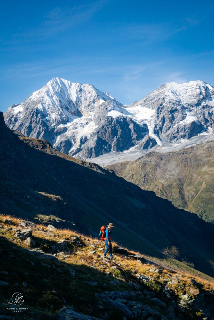
After exiting the chairlift, head right, following signs to Rosimtal Valley (trail 13). Across the Solda Valley, the Ortler massif continues to mesmerize. From this particular vantage point, you’ll see Ortler, Zebru, and Königsspitze.
After about 30 minutes, you’ll reach the Rosimböden mountain pastures. Make a right, crossing the Rosimbach stream, leaving trail 11 behind.
The trail ascends steadily, albeit gently, across tussock slopes and then fields of stone. Though the terrain looks somewhat intimidating from afar, the path is very well-made, so there’s no difficulty in conquering those 800+ meters. That being said, you’re hiking at an elevation around 2700-3000 meters, so you may experience shortness of breath. We certainly did.
As you near the Schöntaufjoch (Passo di Beltovo) mountain saddle, the trail becomes increasingly narrow and steep.
Schöntaufjoch (Passo di Beltovo) to Zufallhütte (Rifugio Nino Corsi)
From Schöntaufjoch (Passo di Beltovo) bear right, following the ridge. The path will be more obvious in a few meters. In a linear fashion, you’ll continue below the ridge, until arriving at Madritschjoch (Passo Matriccio) mountain saddle.
From the saddle, descend along trail 151 through Madritschtal Valley until reaching Zufall mountain hut. The initial descent is quite steep.
Trail 151 is also a mountain biking route, which was unnerving at times. It’s important to exercise caution.
Stay in Zufallhütte Mountain Hut
Zufallhütte is an exemplary example of a mountain hut. Managed by a jovial and helpful team, you’ll feel an instant longing to return. It’s that feeling you get when you don’t want a good experience to end.
It’s obvious that the manager delights in his job. He ensures that everyone feels at ease and welcome, and orchestrates a joyful experience for everyone.
It’s also worth noting that the dinner was a feast. The portions were overly generous. For those that like privacy, the private rooms are very comfortable.
Reservation | Submit a booking request using this online form.
Payment | Cash only
Showers | Yes, token-operated
Drinking Water | Tap water is safe to drink
Electronic Charging Stations | In room
Half Board or à la carte | half board only
Rooms | Dormitory, and private rooms

Ortler High Mountain Trail Stage 4 (Modified): Zufallhütte Mountain Hut to Hintermartell
Stage 4 Trail Stats
Distance | 15.6 km
Time Needed | 6-7 hours
Elevation Gain | 868 meters
Elevation Loss | 1068 meters
Difficulty | Moderate
Minimum Elevation | 2,067 meters
Maximum Elevation | 3,094 meters
Route | Zufallhütte (Rifugio Nino Corsi) – Trail 151 – Zufallhütte (Rifugio Nino Corsi) – Hintermartell
Lunch Option | Zufallhütte Mountain Hut
Zufallhütte – Plima Gorge – Hintermartell
Ortler High Mountain Trail Stage 4 ascends the Upper Martell Valley along trail 150 to the ruins of the former Hallsche hut. Next, the trail crosses a glacier to Casati mountain hut and ultimately continues to Pizzini hut in Veltlintal Valley.
If you want to do the full stage, with the glacier crossing, you’ll need to organize a certified hiking guide. You’ll find a list of recommended guides on this Stelvio National Park page (“Bergführer im Vinschgau”).
We did a modified Stage 4, where we simply hiked up the upper Martell Valley to a glacier viewpoint and then returned by the same trail to Zufall mountain hut. Essentially, you can hike up the valley for as long as you want. The longer you walk, the better the glacier views.
We returned to Zufallhütte Mountain Hut for lunch and then hiked down to the Hintermartell parking lot via the thematic Plima Gorge Path. Along the path, you’ll see the impressive Plima Gorge from several vantage points, including the Plimaschlucht hanging chain bridge.
From the Hintermartell parking lot, we recommend organizing a shuttle transfer with Ortlerbus to your final destination. However, bus transit is also possible. To get to Hotel Burgaunerhof (where we stayed), it’s a 40-minute journey. You have to take two buses:
Bus 1 | Bus 262 (Direction: Martell Dorf): Martell (Enzianhütte) – Gand (29 min)
Bus 2 | Bus 262 (Direction: Goldrain): Gand – Burgaun (5 min)
Stay in Martell Valley
We stayed in Hotel Burgaunerhof, a perfect ending to a perfect trip.
We absolutely loved this hotel in Martell Valley. Upon arriving, we were welcomed and given a thoughtful and thorough rundown of the hotel (opening/closing times of the wellness facilities, our dinner/breakfast table, dinner menu, etc…).
After checking in, we immediately darted up to the fourth floor to luxuriate in the panoramic wellness area. From the Finnish stone pine sauna, views extend to the forested valley. From the relaxation room, you can meditate on the pastoral scene ahead of you.
Our experience was further enhanced by the gourmet South Tyrolean dinner. Hotel Burgaunerhof is also passionate about wine, offering a number of high-quality wines by the bottle as well as by the glass.
Our biggest mistake on this trip was only staying one night here.
Book your stay at Hotel Burgaunerhof.
Look for accommodation in Martell Valley.
Onward Travel
From Martell Valley, it takes just over an hour to get to Meran via public transit:
Step 1 |Bus 262 (Direction: Goldrain): Burgaun – Bahnhof Goldrain (11 min)
Step 2 | Train(R): Bahnhof Goldrain – Bahnhof Meran (50 min)
From Meran, you can continue to other spectacular destinations in South Tyrol, including the Italian Dolomites.
- Where to Stay in the Dolomites in Summer
- Best Things to Do in the Dolomites
- Best Places to Visit in the Dolomites
- Best Day Hikes in the Dolomites
- Best Hotels in the Dolomites

Discover Northern Italy
Aosta Valley:
Hut to Hut Hiking Trails:
- Alta Via 1 Trek, Italian Dolomites
- 3-Day Tre Cime di Lavaredo Trek
- 3-Day Rosengarten Trek
- Hut to Hut Hiking in the Italian Dolomites
More Hut to Hut Hiking Trails
Austria:
- Best Treks in Austria
- Emperor’s Crown (Kaiserkrone) Trek
- Rätikon High Trail
- Montafon Hut to Hut Circuit
- Eagle Walk
- Schladminger Tauern High Trail
- Venediger High Trail
- Karwendel High Trail
Slovenia:
- Hut to Hut Hiking in Slovenia
- Mountain Huts in Slovenia
- Triglav National Park Hut to Hut Hike, Slovenia
- Kamnik Alps Hut to Hut Hike, Slovenia
Europe:
- Best Treks in Europe
- Liechtenstein Panorama Trail
- Alpstein High Trail
- Fisherman’s Trail in Portugal
- Tour du Mont Blanc Trek: France, Italy and Switzerland

Pin this Image for Future Trip Planning!
Stay Connected:
Connect with us on Pinterest.
Follow us on Instagram.
Like us on Facebook.
Support Us:
If you love reading our content, you can buy us a coffee via Ko-Fi.
