The Berlin High Trail (Berliner Höhenweg, or Zillertaler Runde in German) is a hut-to-hut hiking trail in Tyrol, Austria. This gorgeous alpine route showcases the finest alpine and glacier vistas of the Zillertal Alps.
It’s an extraordinary adventure replete with challenging ascents and descents, rustic and grand mountain huts, and unforgettable glacier and lake views.
This difficult high-alpine trail is best undertaken by experienced hikers. The trail requires surefootedness, a head for heights, comfort with secured exposure, steep slippery descents, and uneven terrain. No special equipment is needed. However, we highly recommend packing hiking poles.
The traditional Berlin High Trail is an 8-day trek starting in Finkenberg (4.5 km from Mayrhofen) and ending in Mayrhofen in Zillertal Valley.
Responsible Travel in the Zillertal Alps Nature Park
The Zillertal Alps are a protected area. During your visit, adhere to these rules:
- Respect the habitats of animals and plants. Picking, or removing flowers, plants, and rocks is not allowed.
- Wild camping is illegal.
- Take all garbage back with you down to the valley. Leave no trace.
- Stay on the designated hiking trail.
- Do not make loud noises (e.g. playing music loudly).
We wrote this Berlin High Trail trekking guide based on our personal experience. Keep in mind that things can change over time: trail difficulty, accessibility, and routing (due to rock falls, landslides, and avalanches) and hut management (reservation system, hospitality, payment, food quality, etc…). Please do your due diligence before tackling this route.
- When to Hike: July, August, or September
- Where to Stay: Mountain Huts only. Camping is strictly prohibited in the Zillertal Alps Nature Park.
- How to Book the Berlin High Trail: Independently. Instructions below. If you want to book a self-guided trek, check out these alternative trails: 6-Day Hut to Hut Light in the Austrian Alps (kid-friendly), 8 Day Culinary Delight Hut Hiking Tour, and 3 Day Culinary Delight Extended Weekend Hiking.
- Overnight Hut Discounts: Discounts are administered to guests with Alpine Club ID cards on which the logo of the reciprocal rights agreement is printed. Learn more about alpine club membership in Tips for Hiking in the Alps.
- What to Pack: Cash, sleeping bag liner (e.g. Sea to Summit liner). Read our Hut to Hut Hiking Packing List.
- Trail Map: WK152: Zillertal Alps
- Tips for Hut Hiking in Austria: Read Hut to Hut Hiking in Austria: Essential Tips and Visiting Austrian Mountain Huts
- Where to Stay Before/After the Trek: Landhotel Rauchenwalderhof (budget), Alpenhotel Kramerwirt (midrange), or ElisabethHotel (luxury) in Mayrhofen
Berlin High Trail Map
The Zillertal Alps are located in Tyrol, Austria, and in South Tyrol, Italy.
This range stretches between the Tux Alps, Kitzbühel Alps, Venediger group, Rieserferner group, the Dolomites, and the Stubai Alps. The best base for exploring the Zillertal Alps is the town of Mayrhofen in Zillertal.
BERLIN HIGH TRAIL STAGES
Where to Stay
Berlin High Trail Stage 1
Berlin High Trail Stage 2
Berlin High Trail Stage 3
Berlin High Trail Stage 4
Berlin High Trail Stage 5
Exit Route
Other Stages
Berlin High Trail Trekking Itineraries
The Classic Berlin High Trail
The classic Berlin High Trail has 8 stages. Stages 2 and 7 are extremely long, challenging and only possible in good weather conditions.
Day 1 | Finkenberg – Gamshütte (7.6 km, 3 hours)
Day 2 | Gamshütte – Friesenberghaus (14 km, 9 hours)
Day 3 | Friesenberghaus – Furtschaglhaus (13.8 km, 5 hours)
Day 4 | Furtschaglhaus – Berliner Hütte (8 km, 6:30 hours)
Day 5 | Berliner Hütte – Greizer Hütte (8.8 km, 6:30 hours)
Day 6 | Greizer Hütte – Kasseler Hütte (9.4 km, 6 hours)
Day 7 | Kasseler Hütte – Karl-von-Edel Hütte (12.6 km, 9 hours)
Day 8 | Karl-von-Edel Hütte – Mayrhofen (8.6 km, 4 hours)
Our Berlin High Trail Hut to Hut Hiking Route
Upon the recommendation of the Zillertal Tourism Board, we started the trek at Schlegeisspeicher (Schlegeis Reservoir) instead of Finkenberg.
Because of dangerous weather conditions, we had to descend early. So, we concluded the Berlin Höhenweg in Stilluptal Valley, instead of Mayrhofen. You can customize your Berliner High Trail trek to your own timeframe and needs, starting and ending wherever you want.
Day 1 | (Mayrhofen) – Schlegeisspeicher – Friesenberghaus – Olpererhütte (10.6 km, 5 hours)
Day 2 | Olpererhütte – Furtschaglhaus (13.1 km, 5:30 hours)
Day 3 | Furtschaglhaus – Berliner Hütte (8 km, 6:30 hours)
Day 4 | Berliner Hütte – Greizer Hütte (8.8 km, 6:30 hours)
Day 5 | Greizer Hütte – Kasseler Hütte (9.4 km, 6 hours)
Day 6 – Exit Stage | Kasseler Hütte – Grüne Wand Hütte in Stilluptal Valley (4.8 km, 1:30 hours) / Taxi to Mayrhofen

How to Book the Berlin High Trail
All mountain huts along the Berliner Höhenweg must be booked individually and independently.
It’s important to make reservations for overnight stays in huts several months in advance. You may be able to book more short-term, if you have a flexible start date.
You can make overnight reservations for most huts along the Berlin High Trail using the Alpsonline online reservation platform.
For more information about booking huts, read our guide to visiting Austrian Mountain Huts. For information about pricing, hut etiquette, joining the Austrian Alpine Club, helpful German phrases to know for hiking in Austria, read hut to hut hiking in Austria.
Arrival Day | Stay in Mayrhofen at Landhotel Rauchenwalderhof (budget), Haus Claudia und Haus Monika (budget), Der Siegeler B&B (budget-midrange), Alpenhotel Kramerwirt (midrange), ElisabethHotel (adults-only luxury), or Hotel Neue Post (luxury).
Stage 1 | Olpererhütte – Online Reservation via Alpsonline
Stage 2 | Furtschaglhaus – Online Reservation via Alpsonline
Stage 3 | Berliner Hütte – Online Reservation via Alpsonline
Stage 4 | Greizer Hütte – Online Reservation via Alpsonline
Stage 5 | Kasseler Hütte – Online Reservation via Alpsonline
Stage 6 | The trek ends in Stilluptal Valley. We recommend staying in Mayrhofen after the trek: Landhotel Rauchenwalderhof (budget), Haus Claudia und Haus Monika (budget), Der Siegeler B&B (budget-midrange), Alpenhotel Kramerwirt (midrange), ElisabethHotel (adults-only luxury), or Hotel Neue Post (luxury).

Arrival Day in Mayrhofen (Zillertal, Tyrol)
The town of Mayrhofen is the best place to stay before and after hiking the Berlin High Trail. There are many dining and accommodation options. Furthermore, there are a number of outdoor sports stores in town.
How To Get to Mayrhofen
The easiest way to get to Mayrhofen is to take a train to Jenbach Bahnhof. From Jenbach, take the Zillertalbahn (Zillertal Train) to Mayrhofen im Zillertal.
Where to Stay in Mayrhofen
Budget | Landhotel Rauchenwalderhof is a cozy and traditional guesthouse in Mayrhofen with an attractive price point. Guests love the location, outdoor swimming pool, and hospitality. Breakfast is included.
Top Choice – Budget-Midrange | Der Siegeler B&B – this lifestylehotel rocks is a newly-renovated bed and breakfast in Mayrhofen, just minutes away from the train/bus station. Enlivened by a pub-style sports bar, this beloved accommodation promises a harmonious blend of comfort and conviviality.
Midrange | The 4-star, centrally located Alpenhotel Kramerwirt is a mere 4-minute walk from the Mayrhofen Bahnhof (train/bus station). This family-run hotel offers spacious rooms, a relaxing wellness area, and a bountiful breakfast buffet.
Luxury | Indulge in pure luxury at Hotel Neue Post, a timeless Tyrolean treasure with roots dating back to the 17th century. Nestled in the heart of Mayrhofen, this 4-star-superior haven effortlessly blends heritage with modern comforts such as a rooftop pool, sauna complex, and well-equipped gym.
Look for accommodation in Mayrhofen.

Berlin High Trail Stage 1: Schlegeis Stausee – Olpererhütte
Stage 1 Trail Stats
Distance | 10.6 km
Time Needed | 4:30 – 5 hours
Elevation Gain | 877 meters
Elevation Loss | 276 meters
Difficulty | Moderate
Minimum Elevation | 1785 meters
Maximum Elevation | 2626 meters
Route | (Mayrhofen) – Schlegeis Stausee (1,785 m) – Friesenberghaus (2,500 m) – Olpererhütte (2,389 m)
Lunch Option | Friesenberghaus
How to Get to the Trailhead: Schlegeis Stausee Reservoir
From the town center of Mayrhofen, go to the train station (Mayrhofen Bahnhof).
Local buses depart just outside the train station. Take bus 4102 to Schlegeisspeicher Reservoir (also written Schlegeis Stausee). The bus ride takes 50 minutes.
There are 16 buses that depart each day, starting around 7:39 am. Check the current bus schedule.
Bus Ticket | around 10 EUR per person
When you arrive at Schlegeis Stausee, head to Dominikushütte mountain hut. The trail to Friesenberghaus begins here.
Schlegeis Stausee – Friesenberghaus – Olpererhütte (5 hours)
From the bus drop-off point, head to Dominkushütte (1,805 m) in the direction of the tunnel. Before reaching Dominikushütte, there is a signed intersection indicating the direction of Friesenberghaus, signed 2 hours. Follow trail 532.
The path ascends and crosses a river via a wood plank and continues through the forest. Eventually, the trail traverses a marshy meadow over a series of wooden planks. The views open up to Schlegeis Stausee. Continue the ascent to Friesenberghaus.
Atmospheric and cozy, Friesenberghaus (2,500 m) is a perfect place for lunch. The hut staff is swift and friendly, and the food is very good.
After lunch, descend a few meters from the hut in the direction of Friesenbergsee lake. After a water crossing, the trail ascends steeply for 170 meters.
The trail levels and you’ll hike along a breathtaking balcony trail to Olpererhütte (1 hour and 15 min).
This stretch of the Berliner Höhenweg is remarkable, as you’ll have continuous views of the Schlegeis Stausee below cradled by 3000+ m peaks.
Shortly before reaching the Olpererhütte, the trail leads across that Instagram-famous suspension bridge.
Stay in Olpererhütte
The perfectly positioned Olpererhütte (2,389 m) boasts the best view of Schlegeis Stausee, Schlegeiskees glacier, Grosser Möseler (3,478 m), and Breitnock (3,215 m).
Resident goats and chickens parade around the hut to the great amusement of all visitors. With large window panels, the interior dining room allows you to experience the beauty of the Zillertal Alps at any time of day.
Overall, this is a great hut.
Reservation | Olpererhütte – Online Reservation via Alpsonline
Payment | Credit cards and cash are accepted
Showers | 3 EUR for a 4 min shower
Drinking Water | Tap water is safe to drink
Electronic Charging Stations | Readily available in rooms
Half Board or à la carte | Both available
Rooms | The hut offers shared rooms for 4 people and shared rooms for 8 people as well as dormitory mattresses (Lager).

Berlin High Trail Stage 2: Olpererhütte – Furtschaglhaus
Stage 2 Trail Stats
Distance | 13.1 km
Time Needed | 5:30 hours
Elevation Gain | 579 meters
Elevation Loss | 693 meters
Difficulty | Moderate
Minimum Elevation | 1784 meters
Maximum Elevation | 2437 meters
Route | Olpererhütte (2,389 m) – Neumarkter Runde – Schlegeis Stausee (1,785 m) – Furtschaglhaus (2,295 m)
Lunch Option | Zamsereck, or Fischerhütte
Olpererhütte to Furtschaglhaus (5:30 hours)
Today, you can decide between two routes. You can descend to Schlegeis Stausee directly (1:30 hours), or via the 3-hour Neumarkter Runde. We recommend taking the longer Neumarkter Runde, because it’s a more interesting trail.
The Neumarkter Runde continues more or less along that balcony trail you hiked yesterday. The focal point is still the sparking turquois reservoir below. The trail crosses a meadow and ascends to a Virgin Mary statue.
It then levels for a while before dropping down a stone staircase-like trail.
After crossing the river over a wooden plank, you’ll see a signed intersection indicating 1:30 hours to Schlegeis Stausee along Trail 535. The trail continuously descends, following the curvature of the river.
Cross the car park and walk over the bridge to reach the reservoir. There are two options for lunch: Zamsereck or Fischerhütte.
From the Schlegeis Stausee, it’s a 2:30-hour hike to Furtschaglhaus.
Continue following the wide track around the reservoir. After crossing a concrete walkway, turn right and hike along the Schlegeisbach river.
The trail to Furtschaglhaus (2,295 m) will ultimately cut left, leaving the gravel road. The trail to the hut is steep, but not technical.
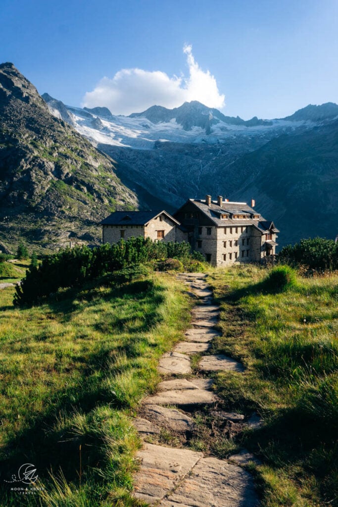
Stay in Furtschaglhaus
Facing glaciated mountains, Furtschaglhaus’ outdoor terrace is a wonderful place to unwind, drink a beer, and socialize with fellow hikers. The hut is surrounded by walls of rock and ice.
When we visited, there were tons of mountaineers at the hut, ready to summit the surrounding peaks. The hut is excellently managed.
Reservation | Furtschaglhaus – Online Reservation via Alpsonline
Payment | Cash only
Showers | 3.50 EUR for a 3 min shower
Drinking Water | Tap water is safe to drink.
Electronic Charging Stations | There’s a charging station in the dining room.
Half Board or à la carte | If the hut is at full capacity, we recommend opting for half board. Not only will you get priority (eat first), but you’ll also get to eat inside. We ordered from the à la carte menu and weren’t served until after they were done serving those receiving half board. Furthermore, waiting outside and then eating outside in the cold was really uncomfortable.
Rooms | Lager or shared-bedrooms available.

Berlin High Trail Stage 3: Furtschaglhaus – Berliner Hütte
Stage 3 Trail Stats
Distance | 8 km
Time Needed | 6:30 hours
Elevation Gain | 930 meters
Elevation Loss | 1180 meters
Difficulty | Difficult
Minimum Elevation | 1970 meters
Maximum Elevation | 3134 meters
Route | Furtschaglhaus (2,295 m) – Schönbichler Horn (3,134 m) – Berliner Hütte (2,044 m)
Lunch Option | Bring a snack, or request a packaged lunch at Furtschaglhaus.
Furtschaglhaus – Schönbichler Horn – Berliner Hütte (6:30 hours)
This is an epic day along the Berlin High Trail and hands down one of the most beautiful trails in the Alps. You’ll be completely engrossed visually and physically.
This stage begins with a steep ascent to Schönbichler Horn peak (3,134 m, 2 hours) characterized by tight switchbacks and increasingly uneven terrain. The final stretch to the peak is secured with ropes.
The initial descent from the peak is well-secured with more ropes. It looks rather intimidating, but we felt quite safe. Surrounded by glaciers, falling ridges and peaks in every direction, the views are sensational.
White glacial ice bleeds into slate-colored rocks, which in turn bleed into grassy-green slopes.
Following the mountain ridge, you’ll continue to descend. The trail gets easier as you progress. Eventually, you’ll see Berliner Hütte and the Zemmgrund Valley. As you lose elevation, it looks like the river is spilling out of the Berlin mountain hut.
As you follow another ridge above the Waxeggbach River, the trail gets increasingly uneven. The path ultimately divides. Left leads you to Waxeggalm and the Alpenrose mountain hut. Right leads you across the Waxeggbach River and to the Berliner hut.
After the river crossing, it’s an easy 30-minute hike to the hut. Cross the gated bridge to reach the grandest refuge in the Alps.
Stay in the Berlin Hut
Visiting the Berliner Hütte (2,044 m) is an experience in and of itself. The wood-paneled dining room, with its high ceilings and wooden chandeliers, is both grand and rustic.
It looks like the perfect setting for a salacious murder mystery, set in the turn of the 20th century.
Reservation | Berliner Hütte – Online Reservation via Alpsonline
Payment | Cash only
Showers | 3 EUR for a 3 min shower
Drinking Water | Tap water is safe to drink.
Electronic Charging Stations | In rooms
Half Board or à la carte | Both options are excellent. The salad buffet is especially wonderful. We opted for à la carte, so that we could order scrambled eggs for breakfast (instead of another bread heavy breakfast).
Rooms | Lager dormitory rooms and private rooms available.

Berlin High Trail Stage 4: Berliner Hütte – Greizer Hütte
Stage 4 Trail Stats
Distance | 8.8 km
Time Needed | 6 – 6:30 hours
Elevation Gain | 1220 meters
Elevation Loss | 1050 meters
Difficulty | Difficult
Minimum Elevation | 1824 meters
Maximum Elevation | 2872 meters
Route | Berliner Hütte (2,044 m) – Schwarzsee (2,472 m) – Mörchenscharte (2,872 m) – Greizer Hütte (2,227 m)
Lunch Option | Bring a snack, or request a packaged lunch at Berliner Hütte.
Berliner Hütte – Mörchenscharte – Greizer Hütte (6:30 hours)
The trail starts out gently. Ascend trail 502 to Schwarzsee (Black Lake), 1:30 hours. This is another profoundly beautiful segment of the Berlin High Trail.
After passing the lake, the trail suddenly steepens. But unlike yesterday, there’s more variation in gradient, so the ascent to Mörchenscharte (2,872 m) isn’t as taxing as the one to Schönbichler Horn.
As you near Mörchenscharte ridge, the trail crosses a field of boulders. The landscape is foreboding and sinister, especially when it’s overcast.
They really ought to rename Mörchenscharte something more dramatic like “secret gate to Hell,” or “the Devil’s passage.” The final stretch to the Scharte (ridge) is very steep.
When we reached Mörchenscharte, the fog-filled up the valley like water in a bathtub. As we descended from the ridge, it felt like we were dipping into a pool of nothingness.
The initial descent is secured with ropes. But after, the switchbacks are very steep and slippery. This is the only place that felt a bit precarious along the Berliner Höhenweg. Be careful.
The trail does get easier. Follow the switchbacks and hike down two additional secured sections before reaching the valley floor.
It took us 2:30 hours to hike from Mörchenscharte to the Mörchenklammbach river.
The trail crosses the valley, including Mörchenklammbach river and Floitenbach river.
After the water crossings, it’s a 1-hour ascent to Greizer Hütte. You’ll likely smell the homemade cooking of the hut well before you arrive.
We arrived soaking wet, having hiked for a few hours in rain. As soon as we stripped off our wet clothes, we settled into the cozy hut and ate up the entire menu, including their homemade Apfelstrudel.
Stay in Greizer Hütte
Surrounded by glaciers and tumbling water in every direction, Greizer mountain hut (2,227 m) feels removed from the rest of the world.
Adorned with red-heart-patterned curtains, the wooden interior is perfectly charming. And there were a few proud goats roaming about outside. We loved everything about this mountain refuge.
Reservation | Greizer Hütte – Online Reservation via Alpsonline
Payment | Cash Only
Showers | None
Drinking Water | Tap water is safe to drink
Electronic Charging Stations | There are several sockets in the hut.
Half Board or à la carte | The food is excellent. Both options are great.
Rooms | Lager and private rooms available. The lager is very tight, so this would be a place to get your own room.

Berlin High Trail Stage 5: Greizer Hütte – Kasseler Hütte
Stage 5 Trail Stats
Distance | 9.4 km
Time Needed | 6 hours
Elevation Gain | 747 meters
Elevation Loss | 797 meters
Difficulty | Difficult
Minimum Elevation | 2101 meters
Maximum Elevation | 2178 meters
Route | Greizer Hütte (2,227 m) – Lapenscharte (2,701 m) – Kasseler Hütte (2,178 m)
Lunch Option | Bring a snack, or request a packaged lunch at Greizer Hütte.
Greizer Hütte – Lapenscharte – Kasseler Hütte (6 hours)
We hiked this stage in unsafe and hazardous weather conditions, so this whole day is a blur. Honestly, IT WAS MISERABLE, which is why I have no notes for this stage.
From Greizer Hütte, it’s a moderate ascent to Lapenscharte ridge (2,701 m, 1:30 hours). The initial descent from the ridge isn’t overly difficult.
There’s a significant boulder crossing, which is tricky to navigate (especially in rain).
Stay in Kasseler Hütte
Reservation | Kasseler Hütte – Online Reservation via Alpsonline
Payment | Cash only
Showers | Available
Drinking Water | Tap water is drinkable
Electronic Charging Stations | Available
Half Board or à la carte | half board, or mountaineering meal
Rooms | shared rooms and dormitory rooms

Berlin High Trail Exit Stage: Kasseler Hütte – Stilluptal Valley
You can exit the Berlin High Trail by descending from Kasseler Hütte (2,178 m) to Stilluptal Valley. We only recommend doing this in cases of bad weather, which is what we did.
We took a taxi from Grüne-Wand-Hütte (1,438 m) to Mayrhofen.
Exit Stage Trail Stats
Distance | 4.8 km
Time Needed | 1:30 hours
Elevation Gain | 2 meters
Elevation Loss | 746 meters
Difficulty | Moderate
Minimum Elevation | 1432 meters
Maximum Elevation | 2178 meters
Route | Kasseler Hütte (2,178 m) – Grüne-Wand-Hütte (1,438 m) – (Mayrhofen)
Stay in Mayrhofen
Budget | Landhotel Rauchenwalderhof
Midrange | Alpenhotel Kramerwirt
Luxury | ElisabethHotel Premium Private Retreat- Adults only
Look for accommodation in Mayrhofen.

More Hut to Hut Hiking Trails
Austria:
- Best Treks in Austria
- Emperor’s Crown (Kaiserkrone) Trek
- Rätikon High Trail
- Montafon Hut to Hut Circuit
- Eagle Walk
- Schladminger Tauern High Trail
- Venediger High Trail
- Karwendel High Trail
Slovenia:
- Hut to Hut Hiking in Slovenia
- Mountain Huts in Slovenia
- Triglav National Park Hut to Hut Hike, Slovenia
- Kamnik Alps Hut to Hut Hike, Slovenia
Italy:
- Hut to Hut Hiking in the Italian Dolomites
- Alta Via 1 Trek, Italian Dolomites
- Tour du Mont Blanc Trek: France, Italy and Switzerland
- Ortler High Trail, Italy
Europe:

Pin this Image for Future Trip Planning!
Stay Connected:
Connect with us on Pinterest.
Follow us on Instagram.
Like us on Facebook.
Support Us:
If you love reading our content, you can buy us a coffee via Ko-Fi.

Hello! Thank you very much for a detailed decsription of the hike. I am going to take it with my 17 years old son this summer. I would like to take the safer and easier option you took (omitting the first 9 hours difficult stage). So I would start as you did, however as I understand your last day was dictated by the bad weather. What was your plan/what would you recommend after Kasseler Hütte?
I would be very greatful for your advice
with my best wishes
Maria
Hi Maria,
From the Kasseler Hut, you can continue along the Berlin High Trail to Edelhütte. Rather than spend another night in a hut, we would continue onwards to Ahornbahn mountain station and descend with the cableway to Mayrhofen. Otherwise, if you want to exit the trail more quickly (if you’re tired, or the weather isn’t promising), you can hike down Stilluptal Valley and take the shuttle back to Mayrhofen from Grüne-Wand Hütte.
Have a great trip to the Zillertal Alps,
Sabrina