Tre Cime di Lavaredo (Drei Zinnen in German) is the name given to three iconic peaks that rise to a height of 2999 meters in the heart of the Sesto/Sexten Dolomites in northeastern Italy.
These striking peaks are located within the Three Peaks Nature Park (Parco Naturale Tre Cime in Italian, Naturpark Drei Zinnen in German) in the Dolomites, one of the most majestic hiking destinations in the Italian Alps.
The circuit trail around Tre Cime di Lavaredo is a very popular day hike. Most visitors will drive all the way up to Rifugio Auronzo via the Tre Cime toll road in order to hike the 4-hour loop trail around the Three Peaks. We wrote about this circuit hike here: Tre Cime di Lavaredo Day Hike.
Experienced hikers can also approach this unmissable Dolomites attraction via Val Campo di Dentro, a side valley of Sesto/Sexten.
While visiting Tre Cime di Lavaredo/Drei Zinnen in a day is certainly an option, we recommend slowing down and hiking hut-to-hut around Three Peaks Nature Park.
Not only will you experience a more interesting and scenic approach to the famous Three Peaks, but you’ll also stay overnight in iconic high-alpine huts (Rifugi in Italian, Hütten in German) along the way.
Our 3-day hut-to-hut route starts in Val Fiscalina (Fischleintal in German) in South Tyrol, one of the most picturesque gateways to the Sexten Dolomites.
This trekking itinerary combines the scenic Val Sasso Vecchio/Altensteintal valley ascent route, the popular Tre Cime/Drei Zinnen loop trail, and the stunning Val Fiscalina Alta/Bacherntal valley descent route.
Read our 7-Day Dolomites itinerary to see how you can integrate this trek into a road trip.
This hike traverses two Italian provinces: Italian-speaking Belluno and German-speaking South Tyrol. Each mountain hut, valley, and mountain has an Italian and a German name. In order to avoid confusion, we use both names as much as possible.
3-Day Tre Cime di Lavaredo Trek Overview
Day 1 | Rifugio Piano Fiscalina/Fischleinbodenhütte Parking Lot (1478 m) – Rifugio A. Locatelli/Dreizinnenhütte (2405 m) | 6.8 km, 3 hours
Day 2 | Rifugio A. Locatelli/Dreizinnenhütte (2405 m) – Rifugio Lavaredo (2344) – Rifugio Auronzo (2320 m) – Langalm (2240 m) – Rifugio A. Locatelli/Dreizinnenhütte (2405 m) – Rifugio Pian di Cengia/Büllelejochhütte (2528 m) | 12.6 km, 5:30 – 6:30 hours
Day 3 | Rifugio Pian di Cengia/Büllelejochhütte (2528 m) – Rifugio Zsigmondy Comici/Zsigmondy Hütte (2224 m) – Rifugio Piano Fiscalina/Fischleinbodenhütte Parking Lot (1478 m) | 7.5 km, 3 hours
Can You Reverse the 3-Day Tre Cime di Lavaredo Route?
Yes, you can!
Do You Need Via Ferrata Equipment?
No, you don’t need any special equipment for this trek, aside from sturdy hiking boots.
We wrote this Tre Cime di Lavaredo trekking guide based on our personal experience. Keep in mind that things can change over time: trail difficulty, accessibility, and routing (due to rock falls) and hut management (reservation system, hospitality, payment, food quality, etc…). Please do your due diligence before tackling this route.
- When to Hike: End of June, July, August, or September
- Where to Stay: Mountain Huts only. Camping is strictly prohibited in Tre Cime Nature Park.
- How to Book the Tre Cime Trek: Independently. Instructions below. If you want to book a self-guided trek, check out these alternative trails: Best of the Dolomites Trek, Alta Via 1 North, Alta Via 1 Central, and Alta Via 1 Classic Route.
- Overnight Hut Discounts: In Alpine Club huts, discounts are administered to guests with Alpine Club ID cards on which the logo of the reciprocal rights agreement is printed. Learn more about alpine club membership in Tips for Hiking in the Alps.
- What to Pack: Passport, cash, sleeping bag liner (e.g. Sea to Summit liner). Read our Hut to Hut Hiking Packing List.
- Trail Map: 3D-Hiking Map Sextner and Pragser Dolomiten 1: 35.000 or Sextner Dolomiten 625 Gps Wp Kompass: Hiking Map 1:25 000
- Tips for Hut Hiking in the Dolomites: Read Hut to Hut Hiking in the Italian Dolomites
- Where to Stay Before/After the Trek: Alta Pusteria
Tre Cime di Lavaredo Trekking Map
TREK STAGES
Where to Stay
Sesto – Val Fiscalina Trail
Stage 1
Stage 2
Stage 3
Tre Cime di Lavaredo Trek Difficulty

This is a moderate hike. All trails are clearly signed and easy to follow. There are no exposed or secured passages.
This Dolomites trek does not require any special equipment. There are no via ferrata stretches along this route.
This 3-day Tre Cime di Lavaredo route is a perfect introduction to hut-to-hut hiking.
Though there aren’t any technical challenges to this route, it’s important to be acclimated and fit.
This was our very first hut-to-hut hike. We were very content with the pace, given our experience at the time. Now, we’d likely condense this trek into 2-days, whereby we’d complete the Tre Cime di Lavaredo Ciruit Trail on Day 1.
Day 1 | Rifugio Piano Fiscalina/Fischleinbodenhütte Parking Lot (1478 m) – Rifugio A. Locatelli/Dreizinnenhütte (2405 m) – Rifugio Lavaredo (2344) – Rifugio Auronzo (2320 m) – Langalm (2240 m) – Rifugio A. Locatelli/Dreizinnenhütte (2405 m) | 16.6 km, 7 hours
Day 2 | Rifugio A. Locatelli/Dreizinnenhütte (2405 m) – Rifugio Pian di Cengia/Büllelejochhütte (2528 m) – Rifugio Zsigmondy Comici/Zsigmondy Hütte (2224 m) – Rifugio Piano Fiscalina/Fischleinbodenhütte Parking Lot (1478 m) | 11.1 km, 4 hours
When to Hike Hut to Hut around Tre Cime di Lavaredo
Between late June and late September, when the mountain huts (Rifugi/Hütten) are open.
It’s likely that there will still be lingering snow on the high mountain trails up until early July.
Note: Wild camping is prohibited

How to Book the 3-Day Tre Cime di Lavaredo Trek
All mountain huts along this Tre Cime di Lavaredo trekking route must be booked individually and independently.
It’s important to make reservations for overnight stays in huts several months in advance.
For more information about trekking in the Dolomites, read our guide to hut to hut hiking in the Dolomites.
Day 1 | Dreizinnenhütte (Rifugio Locatelli) – Send a reservation request using this online form. If you cannot secure an overnight stay in the Dreizinnenhütte (Rifugio Locatelli), you can also stay in Rifugio Lavaredo, or even Rifugio Auronzo.
Day 2 | Rifugio Pian di Cengia/Büllelejochhütte – Send a reservation request using this online form.

Arrival Day in Alta Pusteria
Where to Stay Before the Trek
We recommend staying in Alta Pusteria/Hochpustertal (Upper Puster Valley) before the trek.
If you stay in Sesto/Sexten, or Val Fiscalina/Fischleintal, you can walk from your accommodation to the trailhead.
Alternatively, you can stay in the village of San Candido/Innichen, or even Dobbiaco/Toblach, and take a bus to the trailhead.
Sesto / Sexten Accommodations
Budget | B&B Grüne Laterne – Lanterna Verde in Sexten/Sesto – Waldheim.
Midrange-Luxury | Residence Königswarte
Luxury | Aparthotel Gamz
Luxury | Bad Moos Dolomites Spa Resort is a 4-star superior hotel, located at the entrance to Val Fiscalina/Fischleintal. Boasting a 2500 m2 wellness area and its own sulfur source, this Sexten wellness hotel offers guests the greatest gift of all: relaxation. The extensive sauna complex lures you in with its cavernous, candlelit sulfur grotto, cold sulfur plunge pool (6.1°C), Kneipp trail, and multiple saunas.
Look for accommodation in Sexten.
San Candido / Innichen Accommodations
Budget | Residence Silvia
Midrange | Residence Kugler
Adults-Only Luxury | Post Hotel – Tradition & Lifestyle
Luxury | ATTO Suites

Tre Cime di Lavaredo Trek Stage 1: Val Fiscalina – Rifugio A. Locatelli
Stage 1 Trail Stats
Trailhead | Rifugio Piano Fiscalina/Fischleinbodenhütte paid parking lot | Google Maps
Distance | 6.8 km
Time Needed | 3 hours
Elevation Gain | 955 meters
Elevation Loss | 0 meters
Difficulty | Moderate
Minimum Elevation | 1453 meters
Maximum Elevation | 2438 meters
Route | (Sesto/Sexten) – Rifugio Piano Fiscalina/Fischleinbodenhütte – Rifugio Fondo Valle/Talschlusshütte – Rifugio Locatelli/Dreizinnenhütte
Lunch Option | Rifugio Fondo Valle/Talschlusshütte, or Rifugio Locatelli/Dreizinnenhütte
Val Fiscalina Trailhead

We started this trek at the Rifugio Piano Fiscalina/Fischleinbodenhütte paid car park in Val Fiscalina/Fischleintal valley, a side valley of Sesto/Sexten Valley in South Tyrol. Exact Location: Google Maps.
Recently, local authorities have introduced driving restrictions in Val Fiscalina/Fischleintal during peak summer season. Consult this page for updated information on accessibility and parking.
If restrictions are in place, either take a bus to Rifugio Piano Fiscalina/Fischleinbodenhütte, or walk to the trailhead from Sesto/Sexten village. There’s a beautiful hiking trail that leads through larch meadows to the trailhead in 1:15 hours.
We’ve described this Sesto-Val Fiscalina trail in our guide to visiting Val Fiscalina.
Rifugio Piano Fiscalina/Fischleinbodenhütte to Rifugio A. Locatelli/Dreizinnenhütte (3 hours)

Starting at the Rifugio Piano Fiscalina/Fischleinbodenhütte car park, follow the flat valley path (trail 102) for about 30 minutes to Rifugio Fondo Valle/Talschlusshütte (1548 m).
The path steadily progresses towards the giant peaks of the Sesto/Sexten Sundial: Cima Uno/Einserkofel (2698 m), Crode Fiscaline/Oberbachernspitzen (2677 m), and Croda dei Toni/Zwölferkofel (3094 m).
From Rifugio Fondo Valle/Talschlusshütte, continue on trail 102 in the direction of Rifugio A. Locatelli/Dreizinnenhütte, signed 2:40 hours.
The path ascends very gently to another intersection with a painted billboard, identifying all the significant peaks and side valleys of the immediate surroundings. Head right.
For the next 2 hours, the trail steadily ascends Valle Sasso Vecchio/Altensteintal valley between the Einserkofel/Cima Uno (2698 m) and Crode Fiscaline/Oberbachernspitzen (2677 m) peaks on your left and the Punte Sasso Vecchio/Altensteinspitzen and Crodo di San Candido/Innichriedlknoten (2891 m) peaks on your right.
There’s very little shade along this path and the stone trail reflects the sun like snow. Bring sun protection (hat, sun lotion, and Cat 4 sunglasses like these Julbo Shield Mountain Sunglasses).
After an hour, the trail levels out next to the Altensteinerbach stream. The flat walking is a nice respite, but it doesn’t last long.
As you gain elevation, the Monte Paterno/Paternkofel (2476 m) and Croda dei Piani/Bödenknoten (2712 m) dominate your view.

The high-alpine landscape is defined by rugged, sculpturesque peaks, dwarf pine, and solitary larch.
You’ll pass two beautiful mountain tarns, Laghi dei Piani/Bödenseen, right before reaching the hut.
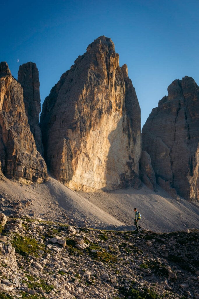
Directly facing the north-side of the iconic Three Peaks, Rifugio Locatelli/Dreizinnenhütte (2438 m) is arguably the most perfectly positioned mountain hut in the Dolomites.
And luckily for all hungry visitors, the hut serves yummy South Tyrolean cuisine.
Stay in Rifugio A. Locatelli / Dreizinnnen Hütte

Dreizinnenhütte is located at an elevation of 2438 meters. Directly facing the north-side of the majestic Tre Cime di Lavaredo, Dreizinnenhütte should be your number one choice tonight. Given the mountain hut’s popularity, book several months in advance.
Reservation | Send a reservation request using this online form.
Payment | Cash only
Alpine Club | Alpine Club membership discounts are administered.
Showers | 10 EUR per person (without a towel). There is only one shower in the hut, which will remain closed in case of water scarcity.
Food | Very good.
Half Board or à la carte | Both available. On Saturdays, half board only.
Rooms | Rooms with 2-, 3-, and 4-beds as well as a lager mattress dormitory.
Check-in | Starting at 3 pm
Check-out | 10 am
Or, Stay in Rifugio Lavaredo
The location of Rifugio Lavaredo is absolutely spectacular. The jagged Cadini di Misurina form the backdrop of this Rifugio.
We stayed in a 6-bed dormitory room, which was clean and comfortable. The staff was very friendly. However, the food was subpar.
Rifugio Lavaredo is situated along the Tre Cime di Lavaredo/Drei Zinnen loop trail, half-way between Rifugio Locatelli/Dreizinnenhütte and Rifugio Auronzo.

Tre Cime di Lavaredo Trek Stage 2: Rifugio A. Locatelli – Rifugio Pian di Cengia
On day 2, follow the loop trail around Tre Cime di Lavaredo/Drei Zinnen (4 hours) and then ascend to the mountain hut Rifugio Pian di Cengia/Büllelejochhütte, the highest refuge in the Sesto/Sexten Dolomites.
We recommend detouring to the Cadini di Misurina Viewpoint from Rifugio Auronzo along the way (add 1 hour out-and-back).
The final ascent from Dreizinnenhütte to Büllelejochhütte is 3.2 km and takes 1:30 hours.
Stage 2 Trail Stats
Distance | 12.6 km
Time Needed | 5:30 hours (6:30 hours with Cadini di Misurina Viewpoint detour)
Elevation Gain | 646 meters
Elevation Loss | 514 meters
Difficulty | Moderate
Minimum Elevation | 2170 meters
Maximum Elevation | 2564 meters
Route | Rifugio Locatelli/Dreizinnenhütte – Rifugio Lavaredo – Rifugio Auronzo – Cadini di Misurina Viewpoint – Rifugio Locatelli/Dreizinnenhütte – Langalm – Rifugio Pian di Cengia/Büllelejochhütte
Lunch Option | Langalm, or Rifugio Locatelli/Dreizinnenhütte
Rifugio Locatelli/Dreizinnenhütte – Rifugio Lavaredo – Rifugio Auronzo (1:30 hours)

From Rifugio Locatelli/Dreizinnenhütte, we recommend hiking clockwise, initially following trail 101 to the Forcella Lavaredo/Paternkofel saddle.
The wide trail steadily advances towards the mighty Three Peaks. When you reach the saddle, you’ll be treated to the most heavenly view of the Cadini di Misurina Group.
Descend to Rifugio Lavaredo and continue along trail 101 to Rifugio Auronzo.
Cadini di Misurina Viewpoint Detour (1 hour out-and-back)

Before continuing along the Tre Cime di Lavaredo circuit trail, we suggest detouring to the Cadini di Misurina viewpoint, a beloved photography spot.
From Rifugio Auronzo, it’s a 30-minute walk to the lookout point along trail 117, the famous Sentiero Bonacossa Trail. The footpath leads south, away from the Three Peaks and towards the Cadini Group.
Read our Cadini di Misurina Viewpoint guide for detailed instructions.
Rifugio Auronzo – Langalm – Rifugio Locatelli/Dreizinnenhütte – Rifugio Pian di Cengia/Büllelejochhütte (4 hours)

From Rifugio Auronzo, trail 105 begins at the end of the parking lot. The trail leads to the saddle Forcella del Col de Mezo and then onwards to the managed mountain pasture hut Langalm.
Langalm is an ideal place to take a break. We stopped here for homemade cake and to enjoy the sun’s short-lived, but well-received appearance.
To complete the circuit, follow trail 105 and eventually 102 to Rifugio Locatelli/Dreizinnenhütte.
We ate lunch at the hut, before starting the ascent to Rifugio Pian di Cengia/Büllelejochhütte, which takes about 1:30 hours.

Trail 101 begins with stunning views of the two Lago dei Piani / Bödenseen lakes. A large section of the trail feels like a graveyard of a former mountain.
Huge dolomite boulders dot the landscape like tombstones. The treeless scenery expands in all directions as you hike beneath Monte Paterno/Paternkofel.
After cresting the mountain saddle Forcella Pian di Cengia/Büllelejoch, it’s an easy path to the mountain hut.
We have nothing but the highest praise for this charming hut. We were blown away by the scenery, cuisine, and friendly service. If you have some extra energy after arriving, hike to the summit of Croda Fiscalina/Oberbachernspitze.
Optional Hike to Croda Fiscalina / Oberbachernspitze (1 hour out-and-back)
Croda Fiscalina/Oberbachernspitze (2677 m) is a soaring mountain peak, which prominently flanks the Val Sasso Vecchio/Altensteintal valley you hiked up yesterday.
It takes only 30 minutes (2 km out-and-back, Elevation Gain/Loss: 100 meters) to reach the peak from Büllelejochhütte along trail 101A. At the top, there are panoramic views of Val Fiscalina/Fischleintal, Croda dei Toni/Zwölferkofel, and Gruppo delle Marmarole.
Along the trail, we saw trenches and tunnels from World War I. Though difficult to imagine now, the front between the Austrian and Italian armies ran through the Dolomites. And, the Sesto/Sexten Dolomites were one of the most contested territories during the war.
Stay in Rifugio Pian di Cengia / Büllelejochhütte
Rifugio Pian di Cengia/Büllelejochhütte is a place where dreams come true.
Surrounded by dramatic mountain scenery and gracing the clouds, the remote Büllelejochhütte is one of the loveliest huts in the Dolomites. The staff was beyond kind and friendly And, the hearty food was divine.
This is a very small hut, which only has two small dormitory rooms. Book early. Also, there’s running water, but no showers.
Reservation | Rifugio Pian di Cengia/Büllelejochhütte – Send a reservation request using this online form.
Payment | Cash only
Alpine Club | This refuge is privately-owned and therefore does not administer discounts to Alpine Club members.
Showers | None
Food | Excellent
Half Board or à la carte | Half board only. You can only stay in this hut if you also book half board.
Rooms | Dormitory only.

Tre Cime di Lavaredo Trek Stage 3: Rifugio Pian di Cengia – Val Fiscalina
Stage 3 Trail Stats
Distance | 7.5 km
Time Needed | 3 hours
Elevation Gain | 0 meters
Elevation Loss | 1094 meters
Difficulty | Moderate
Minimum Elevation | 1453 meters
Maximum Elevation | 2547 meters
Route | Rifugio Pian di Cengia/Büllelejochhütte – Rifugio Zsigmondy Comici/Zsigmondy Hütte – Rifugio Fondovalle/Talschlusshütte – Rifugio Piano Fiscalina/Fischleinbodenhütte car park
Lunch Option | Rifugio Fondovalle/Talschlusshütte
Rifugio Pian di Cengia – Rifugio Zsigmondy Comici – Rifugio Piano Fiscalina (3 hours)
Today, you’ll descend all the way back to Val Fiscalina/Fischleintal via the slopping Val Fiscalina Alta/Bacherntal valley.
Follow trail 101 to Rifugio Zsigmondy Comici/Zsigmondy Hütte, where you’ll surely be greeted by the resident donkeys.
From Rifugio Zsigmondy Comici/Zsigmondy Hütte, follow trail 103 in the direction of Rifugio Fondovalle/Talschlusshütte.
Trail 103 eventually intersects with trail 102 (which you took on the way up).
From the trail intersection, follow the familiar flat track back to Rifugio Fondovalle/Talschlusshütte and ultimately back to the Rifugio Piano Fiscalina/Fischleinbodenhütte car park.
Stay in Alta Pusteria

Val Fiscalina Accommodation | Bad Moos Dolomites Spa Resort (luxury)
Sesto/Sexten Accommodations | B&B Grüne Laterne – Lanterna Verde (budget), Residence Königswarte (midrange-luxury), or Aparthotel Gamz (luxury)
San Canido/Innichen Accommodations | Residence Silvia (budget), Residence Kugler (midrange), Post Hotel – Tradition & Lifestyle (adults-only luxury), ATTO Suites (luxury)

Explore the Dolomites
Dolomites Travel:
- Dolomites Travel Guide
- Where to Stay in the Dolomites in Summer
- Best Things to Do in the Dolomites
- Best Places to Visit in the Dolomites
- Best Day Hikes in the Dolomites
Hut to Hut Hiking Trails:
Dolomites Destinations:
- Val Gardena
- Ortisei, Val Gardena
- Val di Funes
- San Martino di Castrozza
- Alpe di Siusi
- Puez-Odle Nature Park
- Lago di Braies
- Cortina d’Ampezzo
More Hut to Hut Hiking Trails
Austria:
- Best Treks in Austria
- Emperor’s Crown (Kaiserkrone) Trek
- Rätikon High Trail
- Montafon Hut to Hut Circuit
- Eagle Walk
- Berlin High Trail
- Schladminger Tauern High Trail
- Venediger High Trail
Slovenia:
- Hut to Hut Hiking in Slovenia
- Mountain Huts in Slovenia
- Triglav National Park Hut to Hut Hike, Slovenia
- Kamnik Alps Hut to Hut Hike, Slovenia
Italy:
- Hut to Hut Hiking in the Italian Dolomites
- Tour du Mont Blanc Trek: France, Italy and Switzerland
- Ortler High Trail, Italy
Europe:

Pin this Image for Future Trip Planning!
Stay Connected:
Connect with us on Pinterest.
Follow us on Instagram.
Like us on Facebook.
Support Us:
If you love reading our content, you can buy us a coffee via Ko-Fi.

Hi Ladies, doing a road trip trying to follow your 7 day itinerary. Such a great resource THANK YOU!! Some help please for the
3-day Tre Cime di Lavaredo …. not ideal but the only hut bookings we can secure for our dates are Locatelli 4 Jul and Auronzo 5 Jul. Staying Sesto night prior 3 Jul and will need to leave car there. Would really appreciate your advice on best way to complete hike based on these huts please. We are a party of 3 adults mid 50’s-60’s of pretty good fitness (cycling, running, hiking are regular daily activities for us).
Thanks so much Mandy (NZ)
Hi Mandy,
Thank you for reading our hiking blog!
The Dreizinnen Hut and Rifugio Auronzo are only 4.5 km away from each other (1:25 hours hiking time), so it doesn’t make sense to stay in these two huts consecutive nights.
You could potentially do the hike in 2-days with a single overnight in Dreizinnenhütte, if you reverse the route. Take a look at the data points and see if that sounds doable for you. It’s important to acclimate before hiking the trail.
Day 1: Val Fiscalina – Büllelejoch Hut – Dreizinnen Hut
Distance: 11.1 km
Time Needed: 5 hours (without breaks)
Elevation Gain: 1197 meters
Elevation Loss: 237 meters
Day 2: Dreizinnen Hut – Rifugio Lavaredo – Rifugio Auronzo – Dreizinnen Hut – Val Fiscalina
Today, you would hike the circuit trail around Tre Cime and then descend to Val Fiscalina.
Distance: 16.5 km
Time Needed: 6 hours
Elevation Gain: 419 meters
Elevation Loss: 1374 meters
All the best,
Sabrina
Thanks so much Sabrina,
So far using your suggested driving itinerary we are booked as follows, so perhaps you have other ideas how to go about the last few days to maximise our sightseeing/hiking travels of the area?
30 June Santa Madalena
01 and 02 July Ortisei
03 Sesto
04 Locatelli
05 Auronzo (which noted above is not recommended so will change)
06 and 07 not yet booked
08 International Flight departure ex. Venice 3pm
Notes; 30 June – 02 July accommodation Paid in full and non refundable. 03 July booked, but free cancellation, so some flexibility there.
Would really appreciate your thoughts on a better way to maximise our time 3-7th.
Thanks again, Mandy
Hi Mandy,
After hiking the Tre Cime di Lavaredo Trek (2-day variation), I would base yourself in Cortina d’Ampezzo for the final days of your trip. We love the Tofana di Rozes and Croda da Lago Circuit trails, both of which are moderately difficult (some rugged terrain). Otherwise, you could settle near Braies Valley in Alta Pusteria and visit Prato Piazza and Lago di Braies. If you do the latter, check out the Gaisl High Trail and the Hochalpenkopf Circuit.
-Sabrina
Hi! The Dolomites and hut to hut hiking is so overwhelming. Thank you for this amazing resource!
Quick question for you – we are getting a late start to planning our trip so many of the huts are booked. We are currently planning a 3 day – 2 night Tre Cime de Lavaredo trek. We plan to start where you recommend and then we have the first night booked at Rifugio Zsignmondy Comici and a second night booked at Rifugio Lavaredo and then we’ll head back down. I know the huts are only about 4 miles apart, but those were are only options available, so we thought we could do an additional hike or exploring on the short day. Do you think this route would work? I am estimating 6-7 miles on the 1st and 3rd day. Does that seem accurate?
Thank you so much for your help and ideas. It’s a lifesaver.
Hi Tara,
This is what your Tre Cime route would look like, assuming you’ll reverse the circuit around Tre Cime di Lavaredo to maximize day 2.
Day 1: Val Fiscalina – Rifugio Zsignmondy Comici (5.9 km / 3 hours / 772 meters elevation gain)
Day 2: Rifugio Zsignmondy Comici – Dreizinnen Hütte – Langalm – Rifugio Auronzo – Rifugio Lavaredo (12.2 km, 5 hours, 665 meters elevation gain / 547 meters elevation loss)
Day 3: Rifugio Lavaredo – Dreizinnen Hütte – Val Fiscalina (9.5 km, 3 hours, 165 meters elevation gain, 1055 meters elevation loss).
After finishing the trek, you’ll still have a half-day to continue exploring the Dolomites.
All the best,
Sabrina
Thank you so much! Really appreciate it.
Hi there! This has been incredibly helpful. We were only able to get a booking for Rifugio Auronzo Hut on our first day and Rifugio Pian di Cengia Hut on the second day.
Could you please assist me with estimating how long it will take from the Rifugio Piano Fiscalina/Fischleinbodenhütte parking lot to Rifugio Auronzo? Also, will there be maps available to pick up there?
Thank you!
Maggie
Hi Maggie,
It’s 11.4 km (5 hours without breaks) from Fischleinbodenhütte to Rifugio Auronzo. You can purchase trail maps in Sexten. We bought maps in the Tabaktrafic in the town center.
All the best,
Sabrina